Glasco Pike #2 – The Poison Sea 10-21-21
The Poison Sea
On the Rocks; The Woodstock Times; Feb. 3, 2011
Updated by Robert and Johanna Titus
We have been, in this column, spending several months driving west on the Glasco Turnpike. We are actually exploring time. Our goal is to come to truly understand something about the passage of enormous lengths of time and to see how a region changes through those lengths. This is the vicinity of 74 degrees west longitude and 42 degrees north latitude. We want to see how this dot on the globe changed as millions of years of the Devonian time period passed by.
We are also interested in testing the theory of evolution. Darwin’s great theory predicts that the world is very old. Creationists, who challenge the theory, often argue that the planet is only 6,000 years old. Who is right? We shall continue to see some of the evidence.
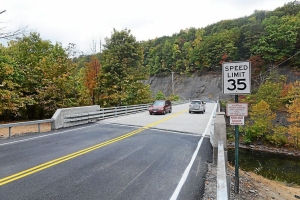
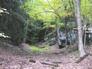
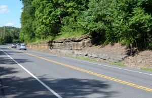
Last time, we visited the Helderberg Limestone, along Rte. 9W. This time let’s turn west onto the Glasco Turnpike itself and cross the bridge. There on the other side is a very fine outcrop. It is definitely not the Helderberg Limestone; it is a towering cliff of fine grained, black rock. The unit has a name; it is the Esopus Shale. That’s a bit of a misnomer as the rock is not actually shale. Geologists have struggled to find just the right name for it, without much success. Some call it the Esopus Grit and that might be as good a name as any. Whatever its name, it does have a story to tell.
If you visit the site, you will see what appears to be stratification in the rock; these “strata” are nearly vertical. That is an illusion. We will come back to this in a later column, but for now, take a closer look. About two thirds of the way up the outcrop, you can see the real strata, they are very faintly seen as bands of dark and very dark gray. These strata, like other rock units in the area, are tilted to the west.
To us, what this rock is today is less important than what it was in the distant past. It is Devonian in age, and a little less than 400 million years old. This dark, fine-grained rock used to be dark, fine-grained sediment. Anybody would have looked at it and called it mud. Back in the Devonian the mud would have been very wet and squishy. It quite likely would have reeked with a foul, maybe sulfurous stink.
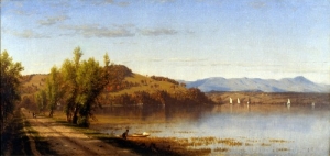
This sort of stuff accumulates at the bottom of a very deep and very stagnant ocean. Stagnant seas never have enough agitation to bring oxygen in from the air above and, in the absence of oxygen, there is no decay. Without decay, all the black organic matter remains well preserved and hence the dark, malodorous nature. Today, the Black Sea of Asia is a modern analogue; scientists, such as Bob Ballard of Titanic fame, have to technology to actually go down and see such a deep seafloors. But we are the mind’s eye and we don’t need technology.
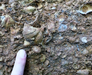
We would like you to stand along the edge of the highway here and wave your hand through the space around you. This space was once at the bottom of a very deep sea. We are the mind’s eye and we can go back to that seafloor. It’s inky black, too deep for any light to penetrate. These are the tropics and the water is quite surprisingly warm. There are no currents down here and, of course, there is no oxygen. All this helps to make it stagnant. Because of that, there are no animals to be seen. No fish have swum in these depths and not even shellfish can be found. It is a spooky place.
It is quite a contrast to our last visit into the past. Recently we stopped along Rte. 9-W and saw the Helderberg Sea. That had been a very shallow tropical sea, something of a paradise in that it had a very rich assemblage of animals living in it. Now, everything is different; the waters are deep, dark and lifeless. What happened?
Between the times of the Helderberg and Esopus Seas, the crust has experienced a dramatic subsidence; it has just plain sunk. The waters have grown progressively deeper. Off to the east there is a rising land mass and off to the west the waters are still very shallow. So the Esopus Sea is an isolated deep basin. That’s how it came to stagnate.
We have just witnessed the sort of dramatic change that can affect a region over a very long period of time, a few million years, no doubt. This is the length of time needed for evolution to occur and this is the sort of environmental change that helped to drive evolution. In this, our second stop down the Glasco Turnpike, we have continued to explore a changing geology that is very much in accord with the Darwinian view. But we still have a long way to go. (Next time: retreat of the sea)
Contact the authors at randjtitus@prodigy.net. Join their facebook page “The Catskill Geologist.”
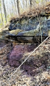 Gray sandstone, above, is river channel deposit. Red shale below formed on floodplain.