Visions on an Art Trail past – Mt. Merino
Robert and Johanna Titus
On the Rocks
We have been touring the Hudson River Art Trail, all this year (2010), and today, sadly, we reach the end of our journey. There are 18 stops up and down in the Hudson Valley, with more being added by the trail sponsor, Cedar Grove, the Thomas Cole Historic Site in the Village of Catskill. This is only number nine, but all the others are quite distant. We have to end somewhere, and we choose to make it here. This final visit takes us across the Hudson River and up to the city of Hudson.
We would like you to go to the Cedar Grove website and navigate to the Art Trail page. Go to the Hudson Valley sites and find stop number nine. It displays an image of Sanford Robinson Gifford’s view of South Bay in Hudson. It was painted in 1864. It’s a pretty scene; the artist was looking across South Bay and toward Mt. Merino. On the left is an old dirt road. It looks to have been an important highway back then. To the distant right Gifford painted the far away Catskill Mountains. He cheated a little to make them look better; he raised them higher than they are. Below the Catskills, a number of sailboats are seen on a very serene Hudson River. To the distant left is Mt. Moreno. Back then the slopes were nearly bare. It was very early autumn and a few trees had just changed color. In the foreground a fisherman is preparing to go out onto South Bay on a small rowboat.
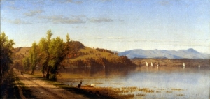
It is a lovely scene, and a very peaceful one; that betrays the fighting going on in Georgia and Virginia on that very day. Gifford knew the scene well; he lived in Hudson and his studio was there. He knew the violence of the Civil War well too; he had served with the Army of the Potomac.
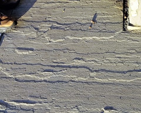
But what does this scene look like today? One of the main purposes of the Hudson River School Art Trail is to allow people to go and see the many locations where these painters worked. We resolved to go and find this site. We crossed the Rip Van Winkle Bridge and headed north on Rte. 9G. We entered Hudson and then started a little exploring. We turned left at Allen Street and left again on South Front Street. About a city block south of the Railroad station we found our destination; it was the very spot where Gifford had worked – 149 years earlier. It wasn’t the same.
We have marveled, in working on this series, how often the sites our artists sketched were still, today, pristine wildernesses. There are reasons for that. Most of these sites lie within the blue line of the Catskill Park; they have been preserved. But not here; Hudson, during the last century and a half, has endured the rise and fall of all sorts of industries. The scars are there to be seen. In the distance we could still see the Catskills and Mt. Moreno; it was the foreground that had suffered. The old dirt road could still be recognized although it was no longer of much importance. It had, no doubt long ago, been paved. In Gifford’s time it was tree lined; today the trees are all gone. In Gifford’s time the road abutted the very edge of South Bay. Now, running along where the old shoreline was, are railroad tracts. In the distance there is an ugly, black metal bridge. The railroad crosses ground that, back in Gifford’s day, was submerged by the waters of South Bay. That’s where it got so much worse. A great deal of old South Bay had, somewhere along the line, come to be filled in. Today it is a broad flat bare earthen surface baking in the sun. We were guessing that, in the past, this filled-in land must have been used for long forgotten industry.
It gets even worse. We slowly turned a full 360 degrees and surveyed the landscape of a beat up, old, and mostly rundown looking urban center. The last 150 years had seen the rise and, even worse, the fall of industry here. It was inevitable; after all Hudson is a city and cities are supposed to be commercial and industrialized. But it was so sad to see; we can only imagine what Sanford Robinson Gifford would have thought.
In the end, it serves to help a person appreciate the value of the Catskill Park. We can, today, enter the park and see so many landscapes, much as they always have been – still in a nearly natural state. Visiting this part of Hudson is a much more somber experience.
But there is more to the story here; there is an ice age history. The story we saw was surprising. It took us back to the end of the Ice Age. The climate all around the world was warming up. Glaciers were melting and the newly freed waters were raising sea levels everywhere. South Bay is one of many similar embayments along the banks of the Hudson River. When you look at the local topographic map you learn a great deal. South Bay lies at the downstream end of a complex tributary system. It began to submerge as those sea levels rose.
Imagine, long ago, when this stream flowed into an older Hudson River. That was when there were still so many glaciers worldwide that sea levels were lower than they are today. So too, the Hudson River and its tributaries occupied much lower elevations than now. The South Bay creek flowed into that lower Hudson River and carved valleys to that lower level. But then the glaciers melted, and sea levels rose. The Hudson rose too and the lower reaches of the South Bay creek were flooded, first with water and then with sediment. So, melting glaciers and rising sea levels combined to create South Bay and its once very handsome natural landscape. Gifford painted it in a near natural state. We should all be glad that he did.
Our journey along the Art Trail is now completed. It is a series of lessons in art. But we found it to offer lessons in ice age history as well. We have very much enjoyed our journeys and hope that you will follow in our footsteps: and also follow in those of our revered artists.
Contact the authors at randjtitus@prodigy.net. Join our Facebook page “The Catskill Geologist.” .