The Zena Ice Field Dec 10, 2021
The Zena Ice Field
On the Rocks; The Woodstock Times, 2009
Updated by Robert and Johanna Titus
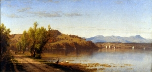
The very first time we ever visited Woodstock, we entered by way of Zena Road. We slowed down at the wonderful view of Overlook Mountain. We remember a cornfield there and that added to the view. Some time later this field was threatened with development. Thankfully, the Woodstock Land Conservancy managed to save it and now the land and its grand view are, forever, just as they were and “have always been.” The site with its view is a very emblem of Woodstock itself. We can all be very glad it has been preserved.

But we are geologists, and we see a lot more when we pull over there and gaze north. We did so recently, and it was quite the experience. We saw the Zena field as it was 23,000 years ago. It was heavily forested then, and we could only see the top of Overlook. The forest was just what you would expect; there were oaks, maples and birch. There were a lot of chestnuts back then too. Many of these were enormous trees, there had never been any cutting in this forest; trees grew to great age and size.
As geologists we were blessed with being able to watch this forest for centuries, a lot of them. We noticed that the summers were getting shorter and grayer. They seemed to stop getting really hot; in fact, it was downright cool and cloudy. There seemed to be fewer warm weather birds. We thought there were fewer summer insects as well; we rarely heard katydids.
The winters were not all that cold though, but they too were overcast. It always seemed to be about 31 degrees out and snowing. We got to be a little weary of the snowfall, but it would not stop. As more centuries elapsed, we noticed that the trees atop Overlook seemed to sicken. Even in late August they seemed pale, even yellow. With more centuries I saw that some of them were dead.
Then down below, we noticed the same affliction in the forest of Zena. Their August leaves were small and yellow. Summer was just not warm enough to allow healthy growth of these trees. What was going on? We were the only humans in all of North America; there was nobody to go and ask.
Now we noticed that the snowfall was lasting into May and then June. The new snows were returning in October and even late September. We are used to climatic cycles, but our droughts are always followed by rainy seasons, our heat waves are balanced by cold spells. We were watching a one-way process. Woodstock was changing into a land without summer. Now the forests up on Overlook were all dead and the trees of Zena were dying as well.
There was something else. we saw weeks of weather when the skies were blue, clear, and cloudless while cold, very dry winds blew steadily out of the northeast. We wondered if there was something cold and dry in that direction. It was a relentless wind that got on our nerves after a while, but it would not stop.
The snows lay on the ground longer into the “summer” season. We saw dirty old snowdrifts in mid July. One summer the ground never thawed out and that was the year all the trees finally died.
Trees don’t make noise, but once they are dead all the noise makers soon leave. We watched as all the birds, all the noise-making insects and all the grunting animals left. The dead forest became unnervingly silent.
But real silence was rare; those howling dry winds soon desiccated the dead trees. Soon, the brittle twigs were blown down, then the branches and finally even the dry limbs crashed to the ground. The forest was a very noisy place . . . until only the tree trunks were left.
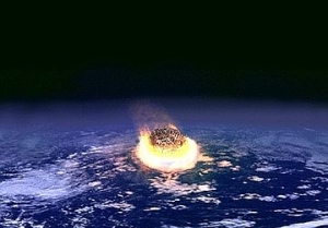
Later we heard a distant crashing and falling sound of a different sort, and then another. Soon this became routine, and we wondered what was going on. It took months, but then we found out. A great glacier was moving south, through the Hudson Valley and it was plowing down all the dead trees. Now, at last, we comprehended. When the glacier got to us, we climbed up upon it and reached its top. Now we had a better view of it all. As far as we could see to the north and east there was a flat, endless expanse of ice. It was a frightening sight. To the west and south, dead forests somberly awaited their destruction.
Then we looked up and beheld a horizon of ice rising above the top of Overlook itself. Soon, this great sheet of ice, thousands of feet thick, stretched from the western to the eastern skyline. Down below, the local ice mostly advanced westward; Woodstock was next.
Reach the authors at randjtitus@prodigy.net. Join their facebook page at “The Catskill Geologist.”
 Top of Comeau drumlin.
 Comeau drumlin just right of center.