"I will never kick a rock"

A Bump in the Road Nov. 22, 2018

in Uncategorized by

A Bump in the Road
The Greenville Press
May 5, 2004
Updated by Robert and Johanna Titus

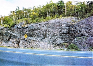
You might call it a hillock, but it’s hardly more than just a bump in the road. Small as it is, it has been posing problems. If you are driving east, you go up and over the bump and then the road veers to the right without much warning. If you are driving west, pretty much the same thing happens only the road veers to the left on the other side. Westbound drivers seem to have the most trouble. If you know the road then there are no difficulties; you know which way to steer. But if you don’t know the road, then you can have real problems on the other side. If you are going too fast, your car may leave the ground for a moment. When you land you have to brake quickly, and steer as fast as you can to avoid running off the road. And there have been some bad accidents here. Two years ago, a helicopter had to be called in to evacuate a victim.

It’s seems that more people don’t know the road on Friday and Saturday nights, but problems can happen on any day of the week. We are talking about County Route 67, across from the Freehold Airport, about a mile west of the Freehold four corners. That little bump in the road seems to always be having accidents. And, even when there are no accidents, it is common to see dark tire marks in the danger zone. People often just avert serious trouble.
These sorts of problems plague many stretches of highway all across the land, but this one is just a little different. This road hazard is also a geohazard. The word “geohazard” was coined some time ago to describe a geological phenomenon that poses a threat to people. Volcanoes and earthquakes are very good examples. Flood prone stretches of rivers are geohazards and so to are landslide prone slopes. So, how is it that some simple bump in the road constitutes a geohazard?
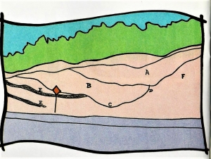
The answer to that question comes from a general survey of the area. This “bump” measures about five feet in elevation and it stretches about 75 feet or so up and down the road. That’s a reasonably large heap of earth. So, how did it get there? If you look just uphill from my bump you will see a fairly decent little canyon which descends from the hill above. Canyons are normally carved by streams, but this one seems the exception; there is usually only a very little water in it. Spring sees a decent flow and the rest of the year is pretty quiet.

And there hasn’t been much water in it for a long time. This canyon is a paleo-form; it is a landscape relict of the ice age. When we started to notice all this, our bump in the road gradually became a very interesting feature. In our mind’s eyes we were transported back to the end of the Ice Age, to a time when the glaciers were melting away from the Greenville vicinity.

April 3, 12,341 BC, late afternoon – This part of the Catskill Creek Valley is very different from what it looks like today. The ice age is ending, and the last glaciers have just melted away from this the lower part of the valley. Up the valley and in the mountains to the south, there is still a lot of ice and it is melting. Catskill Creek is swollen with all the meltwater. It doesn’t even resemble today’s creek. A complex plexus of intertwined streamlets crisscrosses the valley floor. The waters are all brown with mud. In between the streamlets are many low sandbars. Actually. “mudbars” would be a better term for what is here. The mud is shining in the late afternoon sun.
There is some vegetation, but not what we are used to today. The middle reaches of the slopes above me are littered with small pine and spruce. These trees have been migrating north, following the melting ice; they are quite capable of broadcasting their seeds fast enough to keep up with the melting. Someday, there will be real forests here, but that will not be for decades. Meanwhile, up in the Catskills, the slopes are barren except where ice still prevails.
We are standing just east of our bump in the road. From above us, to the right, is the roar of a great torrent of water pounding out of the hill above. This is a meltwater stream and it is white with foam and very noisy with the power of its flow. After cascading out of the canyon above, its currents “land” on the valley flat. The pounding currents splash down and generate a great spray of water. It catches the sunlight in a beautiful rainbow.
Beyond the water reforms itself into a small stream which flows quickly off into the currents of Catskill Creek. These waters leave behind a growing pile of earth. This is the sediment that our meltwater stream has eroded out of the hill above. The torrents were very capable of carrying this material down to the valley flat, but once the current reached that flat, it slowed down and was unable to transport its sediments much farther. That heap of earth was forming into a fine fan-shaped structure. Thousands of years later when the next geologists would come here, they would call this feature an alluvial fan.

Our journey into the geologic past of Route 67 had offered a view of the formation of our bump in the road and it had also explained the canyon above. Now we could take another look at this whole stretch of the highway. Soon, we would see more ice age canyons. There is a fine one right across from the airport’s “art gallery” building. This one deposited another little bump in the road, but there it is not quite as high and there are no surprising bends in the highway. It causes fewer problems. Then, there is another just short of Storey’s Nursery; the old gray farmhouse was built upon that one. This one is very low, and the road is straight, so it should not be a geohazard.
All in all, it would seem that this stretch of Catskill Creek had more than its share of ice age drainage. We are guessing that the hill which makes up the O’Hara Corners area had a fair amount of ice on it after the rest of the local glaciers had cleared Catskill Creek. As this iced melted our several little canyons were temporarily glutted with meltwater. For a short period of time these canyons were very erosive.

Contact the authors at randjtitus@prodigy.net. Join their facebook page “The Catskill Geologist.”

The President in a Slump Nov. 15, 2018

in Uncategorized by

Mudslinging in the Hudson Valley
The Vanderbilt and Roosevelt mansions
On the Rocks
Feb. 23, 2007
Updated by Robert and Johanna Titus

The east bank of the Hudson River was once a very fashionable location where only the very best people lived. Such times and attitudes have faded, but a legacy still remains; along that bank of the river a large number of very fine old houses can be seen. Vanderbilt’s, Livingstons, Roosevelts and other notables may not live there anymore but many of their old homes remain as public parks. Well cared for, these old homes should last a very long time. But just how long is “a very long time?”
To a geologist a very long time is, well, not so long. When we visited The Vanderbilt and Roosevelt homes recently, we noticed that the two had something in common. Both are built upon the same geological foundations and both, eventually, will face the same fates.

Wander around the grounds of the Vanderbilt estate. You will very likely enjoy seeing an abundance of very old and very large ornamental trees. And then there is the house itself, it’s quite a sight too. What you probably won’t notice, at least not right away, is how flat the grounds are. This is no accident; we are looking at the top of a delta that once stuck out into a lake that was here. That delta was part of Glacial Lake Albany, the great ice age lake that once filled the Hudson Valley. Delta tops, more often than not, are flat as a pancake. The fine-grained muds that accumulate upon them settle down in flat sheets. But Glacial Lake Albany is long gone, it drained about 14,000 years ago and that left the delta high and dry. The whole town of Hyde Park is one large dry delta top. That’s what made the Vanderbilt site such a desirable location. The house sits upon a high flat delta top, commanding a very fine view of the river. The Vanderbilt’s couldn’t resist it.

                                                                Vanderbilt mansion – on edge of Hyde Park Delta

All this is the case for the Roosevelt home and many, many others. But scenic though these river view sites are, there are long term hazards. Just in front of both the Roosevelt and Vanderbilt homes are steep, almost vertical slopes. This is not accidental, there is a pattern here and nature is sending out a warning. These steep slopes are the headwalls of what geologists call “slumps.” What has happened here is that large cohesive masses of old lake muck have detached along curved fractures and slid downwards. This is an intermittent phenomenon, it happens occasionally during relatively brief periods of movement and then there is little activity for very long periods of time. The hazard is thus somewhat like that of an earthquake: long periods of quiet, interrupted by moments of destructive activity.

Springwood – The Roosevelt Mansion – on edge of  Hyde Park delta

What triggers a slump? Most likely a period of very wet weather. The old lake sediments become waterlogged and unstable. They become very soft and go through an episode of slumping. By the time that is over, the climate has probably dried out enough to delay further action for another long while.
Wander the grounds of these fine old mansions and you will soon find a number of large semicircular slump features, right at the edges of the old delta. These are places where, long ago, slumps occurred. At the bases of those large semicircles the ground is hummocky. Those are the downhill scars of the old slides. The landscape speaks to us of slumps long past, but it also speaks to us of slumps yet to come. That’s what this column is all about. Someday, probably a very long time from now, the very land beneath these fine old mansions will become wet and unstable. The earth will heave and some or even all of the mansions will collapse. It’s a sad fate for some fine old mansions, but Nature does not discriminate in favor of the wealthy, Nature does not care.

Contact the authors at randjtitus@prodigy.net. Join their facebook page The Catskill Geologist.”

Druid Rocks Nov. 8, 2018

in Uncategorized by

Druid’s Rock
Windows Through Time
Updated by Robert and Johanna Titus

In the season of the summer solstice, Druids, or people who call themselves Druids hold celebrations at Stonehenge in England. Theancient rocks draw large crowds of Pagans and they often act that way; battles with police have been common. Throughout much ofEngland there are many locations where large monoliths rise vertically above the plains. There is little mystery about how these rocks got where they are; they were placed upright thousands of years ago by ancient Celts. Why they were erected is a different question and a bit of a mystery; reasons that have been debated for centuries. The only two things about them that are not mysteries are that they are eye-catching and intriguing, especially the large ones.

Few people know it, but we have some “Druid Rocks” right here in the Catskills and there is some mystery about them as well. The Druid rocks, the ones we speak of today, are found near the site of the old Catskill Mountain House Hotel at North Lake. Back in the days of the hotel, the surrounding forests had many paths that have since been lost to the returning forests. The old pathways led hotel guests past all of the interesting sights of the area and these included many large boulders.
In the hill above the hotel there is a ledge, simply called “third ledge,” which is composed of a rock called puddingstone or conglomerate. The rock is made up of cemented gravel and cobbles. It is a remarkable rock and most fun to examine carefully. Third ledge towers above South Lake and along its edge there are a number of large boulders leaning against the wall. These are the Druid Rocks; the name was given because of their striking similarity with those of the Salisbury Plain. The old trails took people right past those rocks. Back in those days, they would have been much easier to get to and probably easier to explore.
Of course, there is at least one problem here; there were never any Druid cultures in the Catskills. Indians, who did live here, did not erect stone monoliths, at least not these ones. So how did out Druid rocks come to be? The answer most likely takes us back to the Ice Age. During an event called the Grand Gorge advance, about 18,000 years ago, there was a glacier advancing up Kaaterskill Clove. The ice thickened until it got so high that it flooded right out of the clove and expanded across South Mountain. When this sheet of ice got to the north end of South Mountain it plucked loose a large number of boulders and dragged them away. Plucking is a very common glacier behavior; the moving ice sticks to the bedrock and yanks it loose. When all this was well along, a great ledge of rock was created. The glaciers are long gone, but that ledge is still there and so are at least some of the boulders.
Plucking loosened boulders and dragged them off, but if the ice melted quickly enough, boulders could be plucked and left behind. Third ledge was plucked and some of its boulders were left behind. They are the Druid rocks. One, among them, is particularly impressive. It is an enormous rock. It stands almost exactly on end, just like the real Druid rocks of England. There is nothing terribly surprising about this. It’s just luck that left this one on end. Such a thing is unlikely but then, none of the other rocks come in this inclination. As we said, it’s just luck.
But it is also a very impressive rock. Getting there is not all that easy, however. First, go to North-South Lake State Park. At the southwest corner of the South Lake parking lot there is an unmarked entrance to an unmarked dirt path. If you can find it, you can follow its zig-zagging path up the hill, eventually to Druid Rock. From South Lake there is an old carriage trail that leads to the Hotel Kaaterskill site. Part way up the hill there is another path that branches off to the left (east). That path takes you right along the top of the old plucked ledge and eventually, it will lead you to Druid Rock. Big as it is, however, Druid Rock is well hidden in the forest so be patient and there is a real chance you may not find it at all. Half the fun is in the hunting. The very best thing to do is find someone who knows where the rock is and have them lead you to it.
================================================================
Contact the authors at randjtitus@prodigy.net. Join their facebook page “The Catskill Geologist.”

Silence of the Limbs – Nov. 1, 2018

in Uncategorized by

SILENCE OF THE LIMBS
Updated by Robert and Johanna Titus
The Woodstock Times
Nov. 14, 1997

It’s November and the hiking season is winding down. There are still a few relatively mild days, but there are so many fewer reasons to get out now. The foliage with its green is gone and the landscape is for the most part just a dull gray. Darkness comes so early now. Later the snow may draw some of us out on skis or snow shoes, but that is yet to come. For the time being the scenery is uninspiring.
But we have found that there is one outdoors experience which is pretty much confined to this time of year, and it is something that does sometimes draw us out for one last end of the season Catskill hike. It’s not something that we can go and see, nor something that we can hear or feel. Instead it is the very silence of the woods at this time of year.
Each November brings a few days when the skies are a uniform gray, and the gloomy weather patterns seem to settle into complete doldrums. Pick one of those days and hike high up into the Catskills so that you are far away from any road noise. There are usually no planes above our mountains, but if so just wait until they have passed by. Pick a good spot and sit and listen. Not a breath of air stirs, and even if it did a little, there are no leaves to rustle at this time of the year. Once in a while a twig will fall, but these events are scarce and momentary. The forest becomes so completely silent that it is almost unnerving.
In this season of the year there are few animals stirring. The insects are seasonal, and this year’s generation has all died; the next generation sleeps in its egg cases, silently awaiting the spring thaws. The song birds have departed, and most of the ground animals have settled into some burrow for the winter. In short it is mighty quiet up in the mountains at this time of year.
To a geologist there is a special experience here. Silence is unusual in our world, but that is only our world that we are talking about. Today we expect the woods to be noisy with insects, birds and furry animals, but that has not always been the case. Long ago these noise-making creatures did not exist. We are thinking of the Gilboa Forest which long ago presided over our Catskill landscapes.
The Gilboa Forest was a very different sort of woods. There were no furry animals, neither were there birds. There were insects, but they were so primitive that they had not yet evolved the ability to make noise (or even hear it). Noise making is something we take for granted, and probably regard mostly as a nuisance. But we should not forget that it is a relatively complex form of animal behavior and that was something far beyond the abilities of Gilboa’s primitive creatures.
Neither were the trees of Gilboa very noisy. They lacked true leaves and so it is not likely that they would have been able to make much of a rustle. Even on a windy day, the forest of Gilboa must have been a remarkably quiet place. All this silence ended, maybe 300 million years ago, when more advanced insects appeared and began their songs. Eventually birds and other animals followed suit and the world’s forests and jungles became noisy.
So that is what draws us into the mountains at this time of year. It’s a chance to go and experience a form of nature that has been gone for all those 300 million years. We like the western slopes of Hunter Mountain. These face the interior of the Catskills and are shielded from the cacophony of the Hudson Valley. Near Woodstock we would hike up to Overlook Mountain and turn down the yellow trail to Echo Lake. On a real quiet day, the lake’s name should truly be a misnomer. Try it; it’s this year’s one last good excuse for a hike into the mountains.

==============================================================

Contact the authors at randjtitus@prodigy.net.   Join their facebook page “The Catskill Geologist.”

Becraft Mountain Oct. 25, 2018

in Uncategorized by

The Columbia County Catskills
Stories in Stone
Columbia County Independent
Updated by Robert and Johanna Titus
Feb. 18, 2005

Columbia County is certainly a nice enough area, but few of you probably would
guess that anything here is really nationally known. Nevertheless, in geology circles, there is one nearby spot that is truly famous. This location is known as the Becraft Hills or, to many geologists, Becraft Mountain. You would be amazed to discover how many geological maps of this site are found in college level geology lab manuals. Every semester thousands of geology students do exercises involving the geology of the Becraft Hills.
And they have been doing them for generations; there is some classical geology here. You can join in; travel south on Rte. 9 from Hudson and look way up above. You will see some stratified rocks, limestones, high up there. You may not be able to tell it, but these strata are inclined to the east.

Continue south and turn east (left) onto Rte. 23. At the intersection of Routes 9 and 23 you are at the southwestern corner of the Becraft Hills. Before you will be an outcropping of gray limestone. That’s typical of the hills and it is part of what makes them remarkable. These limestones are an isolated bit of the Catskills. The limestones, called the Rondout and Manlius Formations, make up the very base of the Catskill sequence west of the Hudson River. They are the very foundations of those Catskills. As we said there is the whole lower Catskill sequence here. The Becraft Hills have several units of black shales as well.

And this stratigraphy speaks to geologists; it tells us that once, long ago, the stratified rocks of the Catskill sequence extended eastward, across the Hudson, and blanketed much or all of Columbia County. How could that be?
The structure tells all; we already saw that the strata on the west side of the Becraft Hills mostly are inclined to the east. Continue east on Rte. 23 and turn left on Fingar Road; make another left on Hiscox Road, and one more left onto Rte. 29 (aka Spook Rock Road). Now to your left (west) you will see some fine strata of limestone. All these beds are dipping to the west. In short, the western strata dip east and the eastern strata dip west (do you follow that?). That gives the Becraft Hills a bowl like structure, something that geologists call a syncline.
That takes us back to a time called the Devonian, a little less than 400 million years ago, when the mountains of western New England were being formed. The mountain building event was called the Acadian Orogeny and it involved a lot of uplifting of all the area’s bedrock (after all you have to have uplift to form mountains).
You also get a great deal of folding of the strata and that is how we formed the Becraft sequence. We should say protected the Becraft sequence. Mountain building uplift should have elevated the Becraft Hills and subjected them to processes of erosion that, in the end, would have destroyed them. Instead the Becraft strata were folded downward into the bottom of that syncline bowl where they were protected from erosion. All across the rest of Columbia County the Catskill sequence eroded away, but not here.
. Geologists sometimes call such an erosional remnant an outlier and, by itself this would make it worth the visit of a geology class, but there is more. The Becraft Hills, it seems, are also shot through with faults. You have heard of the infamous San Andreas Fault and you know how earthquake-prone all of California is. Well, back during the Devonian time period, those nearly 400 million years ago, Columbia County was something of a California-like earthquake zone. Those ancient faults, now long inactive, can be seen and mapped by geologists.
All this is something that geology teachers cannot resist. Every year scores of geology field trips visit the area. Watch, come next spring, for the large vans with school names on their sides. Look for a dozen or so scruffy college age kids happily climbing about on the rocks. These are field trips and they are a real institution among geology departments.
And they have been for a long time. The first geologists started studying here in the 1820’s. A century or so ago the area became a popular location for summer field geology courses. Back then, before cars were available, the relatively large number of geological features in a small area made this a very practical place to teach and learn geology. We wish we could see some of those old horse and buggy field classes. Generations of young geology students cut their teeth on the rocks here. Later, when transport had improved considerably, it became preferred to travel to the American West to do full-fledged field camps.
some geology and a very large number of young geologists still come here. Take the tour yourself.

=======================================================
Contact the authors at randjtitus@prodigy.net. Join their facebook page “The Catskill Geologist.”

Depths of depression Oct. 18, 2018

in Uncategorized by

Stories in Stone
Depths of Depression
Woodstock Times
Mar. 5, 1998
Updated by Robert and Johanna Titus

The sinking of the Titanic is one of the great stories of history. It’s complete with drama, heroism, and even suspense–despite the inevitable ending. Throw in a little romance and no wonder that the current movie has been such a hit. Part of the movie’s success is the allure of the deep. The ocean’s great mysterious abyssal plain retains, even today, a compelling fascination. To scientists, however, equally gripping was the story of the discovery of the sunken liner. You remember it. Intrepid oceanographers, from the Woods Hole Oceanographic Institute, descended to the depths of the ocean’s great abyss in tiny submarines. Powerful headlights shined upon the sea floor and then upon the long unseen wreckage itself. What an incredible moment! The substance of fiction became history.
The depths of the seas had long been shrouded in mystery, and to see actual film from the deep is one of the great achievements of our times, certainly ranking with anything that our space programs have achieved. Much of the abyss is monotonous mud, but there are those many shipwrecks, and a whole exotic ecology of truly wondrous and intriguing animals.

All of this imagery is made even more appealing by the seeming impossibility of traveling to the bottom of the deep sea. Few of us, after all, get invitations from the Woods Hole. If you could visit the great abyss, would you leap at the chance, or would you shrink from the real danger of the journey? Would a good movie be enough, or would you have the adventurous streak needed for that perilous trek to the very bottom of the sea? It is dangerous; people have died down there.

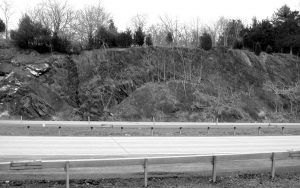
Let’s make it easy. We can have you onto the abyss in probably a bit less than an hour and it will be no more dangerous than a short car ride. Find your way across the Rip Van Winkle Bridge and then go exploring. It doesn’t much matter which way you go; you soon find outcroppings of black sedimentary rocks.

There is nothing figurative in our remarkable claim; this is really the bottom of a sea–or it was. Rising along the sides of the roads are cliffs of dark black shales with occasional sandstones. These accumulated at the bottom of a deep sea, one that was here nearly 450 million years ago. It can be called the Normanskill Sea and the layers of rock you see here were once the muds that made up its bottom.

It’s a curious thing, but way back then, the Ordovician time period, most of New England was rising into a substantial mountain range. These, the Taconic Mountains, would reach heights of maybe 15,000 feet, and perhaps a lot more. As they were rising, however, the crust of the adjacent vicinities, including today’s Hudson Valley, became depressed. Given time, a fairly substantial deep sea was produced. How deep? We don’t know for sure, but it might well have rivaled some of the deep marine trenches of today’s Pacific. It was a still, mud-bottomed, dark and very silent ocean floor.
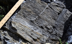
Much of the roadside exposures are thinly bedded, black shale. That was the mud. Those layers piled up slowly over uncounted centuries. Each thin horizon had its moment, each was once the sea floor. With time, another and then another thin seam of mud would accumulate. As the weight piled up the mud was squeezed and hardened into shale.
The dark sandstones are somewhat different. These were more active influxes of sediment, moments when masses of sand tumbled into the depths.

There were living creatures at the bottom of this sea, but few large enough to leave fossils. They lived quiet lives in the Normanskill Sea; no crashing ocean liners interrupted their lives. Scientists did come and visit them, but not until nearly 450 million years after their deaths.

=========================================================================

+++++++++++++++++++++++++++++++++++++++++++++++++++++++++++++++++++++++++

Contact the authors at randjtitus@prodigy.net. Join their facebook page “The Catskill Geologist.”

Ripple Marks Oct. 11, 2018

in Uncategorized by

Our Readers Rocks: Ripple Marks
Windows Through Time
Register Star newspapers
Dec. 3, 2009
Updated by Robert and Johanna Titus

Dear Professors Titus: I dug up this unusual rippled rock in my garden. Can you tell me about it? Did it form at the bottom of the sea? Norma Coney, Gilboa.

                                                                               Photo courtesy of Ralph Ryndak

Dear Mrs. Coney: We are glad to have your letter and photo and we are happy to write about these interesting sedimentary structures. They are striking features and they are important. Geologists find them throughout the Catskills and in many other locales as well. They are called ripple marks, but that term does not explain itself very well. Ripple marks can be the product of several processes. They can, indeed, form at the bottom of the sea, but in your case that is not likely. Gilboa was part of the Catskill Delta back during the Devonian time period when your rocks were formed. We need an explanation which does not involve saltwater and we think we can come up with one.
The first process that forms ripple marks is current activity. Currents, moving along the bottom of a body of water, tend to sweep up particles of sand, along with a little silt and clay, and carry them along. If there is a strong current, then the first few inches above the bottom will be dirty with the sediment. The current sculpts the sediment and shapes it into the ripples that we see. You can tell current ripples because they are asymmetric. There is a steep, but short, downstream slope on one side of the ripple. The other side has a lower angle and that side is the longer of the two. Sand grains are swept along and travel up the long, low slope, called the stoss slope. After they kick across the crest of the ripple, they tumble down the short steep slope, which is called the slip slope. The result of all this is an asymmetric ripple, steeper on its slip slope than its stoss side. These are common on the floors of shallow oceans and at the bottoms of rivers. The stronger the current was, the larger they are.
The other process that creates ripple marks is wave activity. Waves are simple looking when you watch them approach a shoreline, but they are actually pretty complex. Inside a wave are masses of water that are traveling in circular orbits. Each drop of water will travel in its orbit as the wave passes by any particular spot. In effect the drop travels forward as it rises up the slope of one side of the orbit and down the other. Then the water drop is, in effect, traveling backwards as it completes the bottom half of its cycle. Watch the second hand on a clock as it travels “forward” toward three o’clock on the upper half of its sweep and “backwards” towards nine o’clock on the lower half of its sweep. The second hand of a clock does a lot of moving but it never gets anywhere.
Similarly, when our drop of water has completed its cycle, it is right back where it started (just as the second hand of our clock passes by 3:00 every minute). The drop of water doesn’t go anywhere, but the motion wave does travel forward through the water. In effect waves are pure motion; the passes through the water, but nothing else actually goes anywhere!
But, even if the water does not go anywhere, a wave can move sediment. The circular motion of water inside a wave, sweeps sand forward and backwards at it passes by. That forward and backward motion sculpts the sand into the second category of ripple marks. These, called wave ripples, are symmetrical. Both sides of the ripple have the same slope and each side covers the same distance.
Wave ripples can also form at the bottom of oceans or on the bottom of any body of fresh water. Because waves are shallow water phenomena, their ripples tend to form in shallow water settings. Wave ripples are especially common along shorelines. Go to a nearby pond or lake and look at the sand along the shore and see if you don’t find some.

Confused? Just remember: asymmetrical means current/ symmetrical means wave. Do watch for these; they are common and fun to find.
Now, as to the ripples in Gilboa, It’s hard to tell from the photo, but they appear to be asymmetric. Thus, we think that these are current ripples. If that is so, then these were probably formed by the currents of a Devonian age river. This was part of the great Catskill Delta, which accumulated the sediments that make up the sedimentary rocks of all the Catskills Mountains.
Contact the authors at randjtitus@prodigy.net, Join their facebook page “The Catskill Geologist,”

Katydids Oct. 4, 2018

in Uncategorized by

Jurassic Park: The Soundtrack
Stories in Stone
Columbia County Independent
Sept. 4, 2004
Updated by Robert and Johanna Titus

It is our habit to walk our country road late at night just to be out. We live on a quiet stretch of Catskill Creek and it is nice here in the evening. We recently started our walk on a dark, humid, moonless night, one that was fragrant with high summer. We wouldn’t see much but we could listen. What we would hear was the past, and not just the recent past.
The forest above Catskill Creek was surprisingly quiet. A few nondescript insects and late-night birds sang in the trees but there really weren’t many of them. There were other creatures however. In the distance, across the creek, a lone “arrooooo” broke the quiet, and it was followed by another call, and then by a cacophony of howls. It was a pack of coyotes. We have been hearing and seeing coyotes a lot more in recent years. Their tracks and scat are very common, so their cries came as no surprise to us.
We have no idea what they were saying, but it was a grand thing to hear. It’s an ancient wilderness sound. Ancestral dogs first evolved about 50 million years ago at a time called the Eocene Epoch. The sounds we heard are probably that old. Our nighttime walk had brought us our first journey into the past, but it was only a short trip compared to what was to come.
As we continued down the road we passed a dark meadow. There was a different sound there. We have no idea what type of bug it was, but there was a steady insect noise, not a hum but more of a steady wheezing sound. It was a signal that we were entering into the very ancient, nocturnal domain of the insects.


We soon passed under a dark, gloomy canopy of trees. A handful of lightning bugs were still out, but the dark branches above us belonged to the Katydids. They chirped loudly, all were competing for the attentions of prospective mates. Their combined calls created a cacophony of “Katy did, Katy did, Katy did.” Some abbreviated their calls to a quicker “she did, she did, she did.” These were not gossips, just individuals driven by a Darwinian drive to reproduce. This was not music or even musical, but the richness of the sounds on a warm summer night was intoxicating.
Farther along we reached a more open roadway. Above us, we could see the stars. They were bright, having very little other light to compete with. Just a few electric bulbs glittered in our valley. There were a few flashes of lightning from a storm, very far to the north, but mostly it was primeval darkness.
The highlander Katydids had faded into the trees behind us, and they had been replaced by a new sound from the brush below, it was the sound of the lowland crickets. This was a different call, but it had the same Darwinian motive. Crickets are far more melodic and more communal in their calls. They seem to coordinate their chirps. As you walk along you will hear one chirping away. But soon the call from one side of the road will grade, with the same tone and tempo, into the sound of another cricket on the other side of the road. It is as if you had passed from one stereo speaker to another. Why do Katydid’s compete and why do crickets sing in harmony? We are a geologist and a biologist but we don’t know such things, but we do know that both strategies will succeed and next year there will be a new generation of crickets.
Many generations of these singing insects have been around for a long time. They belong to a group called the orthoptera, or straight-winged insects. They appeared probably about 325 million years ago, during the Carboniferous Period and they have been an enormous success ever since. The sounds we were listening to had already been ancient, by the time when the first dinosaurs heard them. And these sounds, though not eternal, will likely be heard for hundreds of millions of years to come.
We continued our nighttime solitude. We soon reached the curve in the road where we customarily end our walk and we sat upon one of the large boulders placed there by the glaciers that once passed this way. We surveyed Catskill Creek in its darkness. There were still occasional flashes of lightning and that storm even managed a little breeze, though it was too distant to bother us.
We sat and listened, mostly in vain, for more sounds. What we had heard was the return of the wilderness in the reforested Catskills. These noisy creatures had been here hundreds of millions of years. Then they were gone and now they are back.
We closed our eyes and now we could not see anything of our modern world. The timelessness of all this became overwhelming. These insect calls were from geological time itself and we had listened. Near us were a few empty beer bottles and a little pile of cigarette butts; We were not the first to sit here. Others come here for other reasons.

Contact the authors at randjtitus@prodigy.com. Join their facebook page “The Catskill Geologist.” Read them in Kaatskill Life and Upstate Life Magazines, along with The Woodstock Times.

Sam’s Point Sep, 27, 2018

in Uncategorized by

Glaciers at Sam’s Point
On the rocks
Robert and Johanna Titus
Woodstock Times
Sept. 19, 2013

The Shawangunk Mountains are certainly one of the most scenic locations in our region, and uniquely so. The Ridge of resistant quartz sandstone towers above the Hudson Valley and offers numerous views of that landscape. One of the most popular locations is Sam’s Point Preserve, near Ellenville on the south end of the mountains. It is a sizable nature preserve with 4,600 acres of land, most of it perched at the top of the mountains at elevations well above 2,000 feet. It’s owned by the Open Space Institute and managed by the Nature Conservancy.
Today this area is valued as a scenic preserve but, in the past, there were commercial uses. The mountaintop here has abundant blueberries and it used to be that people were hired every summer to come here and pick them. Then, in addition, there were several resort hotels; it was, after all an ideal vacation destination.
But we came here to learn about the geology. How had the area’s geological history given rise to this scenic wonder? We came early on a Saturday so that there would still be spaces in the parking lot. We toured the museum, but not for long; our hearts were in climbing atop the mountain. We headed up the trail.


It didn’t take long to figure out why the Shawangunks are there. All along the trail were massive outcrops of quartz sandstone and conglomerate. Quartz is very resistant to weathering and a mountain made out of quartz sandstone will stand out as all other bedrock around it erodes away. The “Gunks” are Silurian in age; that makes them perhaps 420 million years old. Way back then there must have been some sort of coastal plain composed of quartz sand. That would have been similar to our eastern North American coastal plain of modern times. The conglomerates are composed of quartz sand mixed with quartz pebbles. If anything, they are an even more resistant form of rock.

We got up to Sam’s Point itself and soon learned much more about the geological history that went into creating the mountains we see today. We arrived at the easternmost of two platforms, composed of bedrock and seemingly designed for sight-seeing. Naturally, we were more interested in looking down at the rock than gazing at the scenic views. It was, of course, more quartz sandstone, but there was something special that caught our eyes.
There was a polished sheen to the surface of the rock and there were faint striations cut into that surface. We quickly recognized these to be ice age features, common ones at that. Sam’s Point had a long ice age history. Probably going back to the time when glaciers first came down the Hudson Valley, and lasting until the last glacier melted, this site had ice flowing across it. The ice was dirty, carrying a great deal of sand along with it, mostly concentrated at its base. The sand, probably mixed with a lot of silt and clay, actually did polish the bedrock. It sanded it down and planed it off. The generations of people who passed before us had, with their footsteps, worn this down until it was not all that easy to see, but it was there to the trained eyes.
There was more. The glaciers carried with it a large number of cobbles and boulders. As these were dragged across the surface, they gouged scratches into the bedrock. We call these glacial striations. We have seen surfaces like this many, many times so it was hardly a great revelation, but it did speak clearly to us of the fact that there had been a sizable glacier here once. Then we saw more.
We looked up and there was the cliff that defines Sam’s Point. It is another natural platform of quartz sandstone but this one is bounded by a vertical cliff, a big one. Most people would enjoy it as a fine scenic overlook, but our eyes saw back into the ice age. Geologists call this sort of thing a scour and pluck topography. These are common and they are the products of the advance of a glacier. The Hudson Valley glacier advanced from the north and, as it crossed Sam’s Point, it scoured that platform at the top of the cliff. That’s the scour part. Then, as the ice continued south, it yanked enormous masses of rock loose and carried them off. That left a gaping scar in the mountaintop and that is the cliff of Sam’s Point. That is also the pluck part of this landscape.
The cliff faces a compass direction of south-30 degrees-west. That, presumably, was the direction the glacier was traveling. We looked at the striations beneath us, and we had a compass. They too were oriented south-30-west.
Now we had a nice coherent explanation for the topography of Sam’s Point, a real scientific theory to explain everything we saw there. It’s what scientists call an elegant solution to a problem. Everything in the explanation fits the evidence. We would have been flushed with pride at having made such a marvelous discovery were it not for the fact that, no doubt, thousands of other geologists had preceded us here, and had come to the very same conclusions.
==================================================================
Reach the authors at randjtitus@prodigy.net. Join their site “The Catskill Geologist” on Facebook.

Geology at Edna St. Vincent Millay’s Spindletop Sept, 20, 2018

in Uncategorized by

Through the Green forest
Poems in Stone
Robert Titus
Columbia County Independent 2007

My candle burns at both ends; it will not last the night; but ah, my foes, and oh, my friends – it gives a lovely light. Edna St. Vincent Millay, 1920

Many, perhaps most, poets are like Edna St. Vincent Millay; they celebrate, and even live, the quick passage and rapid burnout of life. But geologists are different; we appreciate the endless nature of time and the slowness of the changes that it brings. Geologists and poets are alike, however; they both seek out truths that lie just beneath the surface. My wife and I found this out when we visited Poetry Walk, just down the road from “Spindletop,” Millay’s home in Austerlitz.


The walk had originally been a farm path, carrying cows and firewood. Vincent (as she rather insisted upon being called) valued the walk for its bird sounds, birch grove and mountain laurels. It came to be even more spiritual when her mother Cora was buried there. Vincent and her husband Eugen Bossevain eventually joined Cora in repose at the end of the trail.
Our walk was a search for the truth beneath the surface. However it was not poetry but rocks that we sought out. As we entered onto the walk we found a cairn of rocks. Proudly placed at its top was a small boulder of pure quartz. It was a strange and beautiful rock and I soon noticed quite a few smaller versions lying along the path. I wondered about this odd lithology. Surely, just beneath my feet, the soils graded into quartz-rich bedrock but what was it? The quartz was associated with other rocks: shards of something called phyllite littered the path too. That’s a dark and thinly layered rock. Its laminations are shiny, folded and crinkled. It starts out as shale and is later quite literally crushed and cooked during mountain building events, and turned, or metamorphosed, into today’s rocks. I found metagraywackes too. These had once been dark sandstones but they too had been cooked into something new. Now I guessed one truth beneath the surface, and my geological map confirmed it. Down there, hidden beneath the soil, was something called the Walloomsac Formation, a thick sequence of phyllites and metagraywackes
There was more; a geologist can deduce much from a few rocks. There may be little poetry to words like phyllite and metagraywacke but there is much meaning. The phyllites were mud before they were shale; the metagraywackes were sand before sandstone. And that mud and sand once lay at the bottom of an abyss, the deepest realms of the deepest oceans. Eventually a great mountain building event did the crushing and cooking.
Was I geologist or poet? I had been metaphysically transported to the darkest and deepest realms of an ancient ocean while mountains rose around me. All the while I was physically standing on a modern forest trail.
The end of the trail brought an end to some of my mysteries. Millay and her husband were buried there and a boulder serves as their gravestone. It is a fine metagraywacke with a large thick seam of quartz running along one side. I looked it over carefully and also found numerous small seams of quartz.
The gravestone was a large piece of the Walloomsac, truth that had been brought to the surface. It had been mud and sand in the depths of an Ordovician age abyss, about 440 million years ago. Those sediments had hardened into rock and then they had been cooked by a mountain building event, probably the one called the Taconic Orogeny. Still later these rocks were fractured and hot groundwater penetrated the cracks. It was then that large and small seams of nearly pure quartz had crystallized and filled the empty space.
Rocks burn their candles only very slowly and only at one end. At Poetry Walk they are turning very slowly into soil and “ah, my foes, and oh, my friends – that gives but little light.”
=============================================================
Reach the authors at randjtitus@prodigy.net Join their facebook page “The Catskill Geologist.”

1 30 31 32 33 34 44
Go to Top