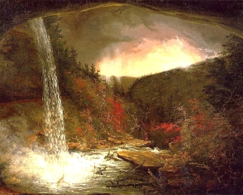
The Devonian of Greene County Part 11
The Red Delta
The Greenville Press
June 5, 2006
Updated by Robert and Johanna Titus
The year 2005 will long be long remembered as the year that the great hurricane hit New Orleans. In many parts of the city the destruction was nearly total, and rebuilding the city was a difficult, expensive and perhaps futile endeavor. Even rebuilt there is no guarantee that another, even worse, storm won’t come along. We, in Greene County, can rest easy. We shall not see that sort of flooding. But, back during the Devonian, that was not the case; back then Greene County must have suffered many such floods. It’s an interesting story and there is a lot about New Orleans that can be learned right here.
You will, we hope, remember from our last chapter that Greene County was once covered by a great delta, called the Catskill Delta. That Devonian age structure was easily as large as the Mississippi Delta and it displayed most all of today’s delta habitats. There were swamps and bayous and floodplains, but most importantly there were rivers, lots and lots of rivers. The general public has recently learned a great deal about such deltas, especially about the flood threats they are exposed to. We talked about some of them in our last chapter.
We learned that it is normal for such deltas to be subsiding. The mass of the sediment deposited on them presses down on the crust and the delta simply sags beneath its own weight. That has been going on in Louisiana for millennia. Some parts of the state are subsiding about an inch per year. That’s fast. What went wrong with all this began centuries ago. Back then the levees of New Orleans started being built to prevent floods. Those levees worked quite well and, in fact, relatively few floods have occurred. But, ironically, the absence of floods has increased the threat of bad floods. It has meant that there has been no new deposition along most of the Mississippi River, especially at and upon New Orleans. You see, normally, flood waters carry sediment onto the delta plain and the resulting sedimentation keeps up with subsidence. As the delta presses down, flood deposition maintains a constant level just above sea level. But since New Orleans came to be “protected” by levees it has sunk but no new sediment has been able to “keep up” with the sinking. Instead, as New Orleans continued to subside, people have just kept raising the levees. It was a race between man and Nature; Nature has won, she always does, and the results were very predictable.
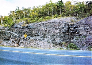
Few people can appreciate the relentless nature of such subsidence. How can they; they just can’t see the results? Subsidence buries all the evidence of itself. Well, surprisingly, here in Greene County, we can see the evidence. Go south on Rte. 32 until you reach its intersection with Rte. 23 where that road begins its ascent towards Windham. All along the road from the bottom of the mountain to on past Point Lookout you will observe a seemingly endless sequence of mostly red shales and red sandstones.
This is, all of it, the Plattekill Formation. We learned a lot about the sandstone and shale in the last installment. The sandstone represents the channels of many ancient, Devonian Catskill Delta rivers. The sand had been carried in the stream channels. Eventually it came to be lithified into sandstone. Most of the shale formed originally as soils and flood deposits on the floodplain surfaces in between the channels.
We saw all of this in the last episode when we visited the Ashokan Formation, along Rte. 23 in Cairo. The difference here is that red color. That brick red is particularly handsome, and it is characteristic of the Catskills as a whole. We owe a lot of our region’s picturesque appearance to it. Why is it there? This red is from the mineral hematite, an iron oxide which forms mostly in well oxygenated terrestrial landscapes. Also, it is most common in tropical settings; red soils are very common in the Amazon and Congo Basins.
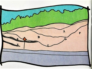
So, the Catskill Delta was a great red tropical Devonian landscape. But our interest is in relating it to New Orleans. Let’s get back onto Rte. 23 and head up the mountain. Just a short distance past and across the highway from the Cornwallville parking area is a fine exposure of a Catskill Delta river. You can see a cross section of the entire channel. The deep side of the stream is on the right and the shallow side is on the left. It is, in short, a “fossil” river. We are not sure if you have ever heard of such a thing as a fossil river, but they do occur, and this is a very good one. And let us tell you, you don’t see them this good just anywhere.
This outcrop sets the tone for the rest of the uphill journey. Watch as you drive along and stop along the way and look at the ledges. There are long thick sequences of red shale; these speak of great delta floodplains. Then, periodically, there are thick sandstone sequences. Those speak of other fossil rivers; none of them, however, are nearly as nicely preserved as the Cornwallville specimen. Horizons of gray and red shale are usually ancient fossil soils. When you come to understand what you are looking at you get a great sense of the time involved. Each of the layers of stratified rock that you pass represents a large amount of time. As you continue uphill you are traveling through a vastness of time, almost more than a person can comprehend. All together, from Cairo to East Windham, you are rising through a thickness of about 1,500 feet of sedimentary rock. That’s a lot of stratified rock and that’s where New Orleans comes in.
One of the critical things to remember in all this and that all of these sediments accumulated at an elevation of just a few (really, a few) feet above sea level. The Cornwallville channel formed at sea level. About 1,500 ft. uphill and across the highway from Point Lookout is another sandstone channel deposit. It also formed at sea level. You might ask “how can 1,500 ft. of sediment be deposited, all of it at just about sea level?” You might think that deposition should pile up to an elevation rising well above sea level, but you have to remember that, just like with the Mississippi Delta, as the Catskill Delta subsided more sediment was deposited. Subsidence and deposition always just keep up with each other.
There is nothing whatsoever unusual about this East Windham sedimentary sequence, these thicknesses are typical of large deltas. And that includes New Orleans. Beneath New Orleans there are many, thousands of feet of sediment that were all deposited at sea level. Above New Orleans there will someday be many thousands of feet more. That will take many millions of years. And after all of that sedimentation, the area will still be at about sea level. And that’s where we really come to understand what has happened to the (once great?) city. Over the centuries, as it was being built, it was being dragged downward along with the subsiding crust. Nothing can stop that process. New Orleans will continue its subsidence. And no matter how high we build the levees, Nature will eventually catch up (as it already has) . . . again, and again, and again. In the end New Orleans will be a “fossil” buried under hundreds and then thousands of feet of sedimentary rock.
Today Rte. 23 takes us to a wonderful place; there is great scenery here. On one side of the highway are beautiful red stratified rocks, on the other side is one of the best panoramic views of the northeast. To relate all this to the tragedy in New Orleans leads to some pretty somber thoughts. It is almost a sacrilege, but it is what we see as we drive up the highway towards Windham.
Contact the authors at randjtitus@prodigy.net. Join their facebook page “The Catskill Geologist.”