What is a limestone? Pt. 1 – June 30, 2022
What is a limestone? Pt 1
Windows Through Time; The Register Star
Updated by Robert and Johanna Titus
Like most people, you have very likely heard the word “limestone.” We use the word frequently in our columns. But do you really know what a limestone is? If you saw one, could you identify it? If not, then let’s go to work and fix that. Let’s learn about one type: a “fossiliferous limestone.”
Limestone is one of the most commonly found types of stratified rock. Stratified means that the rock is layered; it is composed of strata. When you look carefully at a limestone, you are likely looking at a slab of the rock. That slab was originally part of a single stratum. The rock broke up along the surfaces of that stratum to become a loose chunk of rock. When you are looking at such a limestone you are likely looking at the surface of that stratum. And, you are, therefore, looking at a small bit of an actual ancient sea floor. This stratum had been deposited as a sheet of shelly sediment on the bottom of that ocean. That sediment was composed of a large number of shells and shell fragments. These, of course, are now fossils. The sediment in between those fossils is likely to be largely composed of smaller shell fragments. Many of those had been ground down into sediment. That sediment can be sand sized stuff, or even finer. Each grain of sand was once part of a shell. You can’t recognize that anymore, but that is still how it got its start.
That stratum was deposited and then, later, it was buried under more and then even more strata. The limestone sediment piled up and the weight of it helped begin the processes that would harden it into rock. So, any slab of fossiliferous limestone has quite a past. It had once been a soft sediment, lying on the floor of an ocean, but all that has passed; now it is a rock. A very large percent of this rock was once shell material. It could be 100 % but it has to be about 60 to 70% or the rock does not qualify as a limestone.
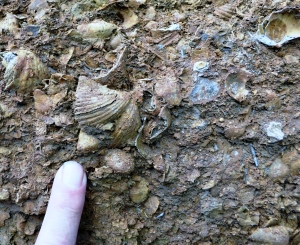
So, identifying a fossiliferous limestone should be simple. And most of the time it is. Take a look at our photo. It’s a close-up of what is called the Glenerie Limestone. (Yes, it is from the village of Glenerie.) It is a Devonian aged limestone, like so many of them around here. The images that leap out of the photograph are the fossils. The one on the left center is a brachiopod, a bivalved invertebrate animal. It’s called a bivalve because it has two shells. That’s just like a clam, but this is not a clam; it is an entirely different creature.
This brachiopod is a full specimen; all parts of both shells are present. It was never broken up.
This specimen is surrounded by fragments of other shells, most of which had also been brachiopods. This rock is an excellent example because, if you could see the original, you would see progressively smaller and smaller shell fragments. It is easy to guess that every particle in this rock was once part of a shell. And that, in fact, is the case. This is a classic fossiliferous limestone. We look again and we realize that we are looking at a small stretch of a Devonian sea floor.
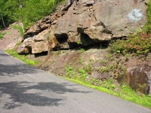
But, can we say more about that ancient sea floor? We sure can, Geologists like to study the modern world. There is so much out there that can help us understand the past. We like to go out and find locations where such limestones are forming today. We have been doing so for centuries and we always find the same thing. Fossiliferous limestones always form on the bottoms of shallow tropical seas. The Bahamas are a terrific example of such a place.
Our Catskills once, about 400 million years ago, lay about as far south of the equator as today’s Bahamas are north. In short, the Glenerie Limestone formed in a Bahamian seafloor setting. We have both been to the Bahamas and so we know exactly what that setting looked like. When we visit the Glenerie Limestone, along Rte.9W in Glenerie, we envision that Bahamian setting.
We don’t even have to close our eyes. We are standing on the soft pink sands of a tropical sea. All around us is that sea floor. And, all around us, are clear aqua-colored waters. Above us, but only about 20 feet up, we see waves passing by, driven by tropical breezes, we see the sunlight sparkling off the passing wave crests. What do you see along Rte. 9W?
Contact the authors at randjtitus@prodigy.net. Join their facebook page “The Catskill Geologist.”
 “Old Man River”