"I will never kick a rock"

Author

Robert Titus - page 41

Robert Titus has 440 articles published.

Hyde Park Delta – revised 3-9-17

in Uncategorized by

 The Hyde Park Deltas – Part one                                     Thecatskillgeologist.com

Robert and Johanna

 March 2016

Most of the time we are re-running old newspaper columns on this site. But we expect to do some original work as well. That is the case here today. We are publishing the first half of a study we recently did on the geology of the Hyde Park ice age deltas. We hope that you will be able to go to Hyde Park and see what we have seen.

This is a new revised version

                                                             ______

The town of Hyde Park is built upon a broad flat platform. It’s a natural landscape feature and it needs to be understood. When you drive into the town, we want you to take note of it. From the north, you pass the Vanderbilt Estate with its endless front lawn. Then the highway passes through the urbanized part of the town. That area is just as flat. Farther south is the Roosevelt Library and Museum. See its expansive and, again, very flat grounds. All this flatness begs to be understood. There is a pattern here, and we always say “when Nature presents scientists with a pattern, she demands an explanation.”

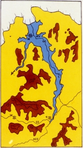
We like to bring a barbeque skewer along with us wherever we go. When we want to investigate this sort of flatland we try to drive it into the ground. If there are rocks, which there usually are, we have little luck. But – if the skewer slides in easily – then we have likely found a glacial lake bottom. That is the case at Hyde Park. Take a look at our map. All the yellow is flatland where there are few, if any, rocks in the ground.

Yellow on map is delta flatland. Base map courtesy of US Geological Survey

   But, is this a simple lake bottom or is there more to the story? Notice that, on our map, the yellow flatlands lie at the downstream end of a stream with the unlikely name of Crum Elbow Creek. Long ago, glacial geologists recognized that that all these flatlands comprised an ice age delta, sometimes called the Hyde Park Delta, the delta of Crum Elbow Creek. The New York State Museum map of ice age features actually portrays two deltas here, one north of Crum Elbow Creek, with a second and larger one, just to the south. This is important, and we should name the two deltas. Let’s call the northern one the Vanderbilt Delta (brown) and call the other the Roosevelt Delta (yellow).

Roosevelt Delta in yellow; Vanderbilt Delta in brown.

   Back during the Ice Age, there was a sizable lake flooding all of this part of the Hudson Valley. It has been called Glacial Lake Albany. Crum Elbow Creek is a long flow of water and, back then it was likely carrying a lot of sediment. Most of that sediment was deposited as the delta where the creek flowed into Lake Albany. The top of a delta is always flat and it roughly corresponds with the old lake level. That’s called the topset of the delta. That would have been at about 180 feet in today’s elevation.

The front of a delta is typically a steep slope called a foreset. That explains another landscape feature that we see throughout Hyde Park. Take a look at our photo from the Vanderbilt mansion. The mansion was located at the top of the steep foreset slope. That offered the Vanderbilt’s a nice view of the Hudson River. Walk north and south from the mansion and enjoy this view.


The Vanderbilt Mansion from the south. Below it is the foreset slope.


Foreset slope, north of the Vanderbilt mansion, with its view of Hudson.

Now we have learned a lot about Hyde Park. You are not likely to be able to pass through town without envisioning yourself in a very different landscape, an ice age one. With your mind’s eye look west and see Glacial Lake Albany spread out before you. It extends all across the Hudson Valley. The lake was almost two miles wide here. That’s about four times as wide as today’s river is.

But, the more we worked the area, the more we saw problems that needed to be explained. For starters, we thought the flow of Crum Elbow Creek was a bit odd. The stream has its head about ten miles north of Hyde Park. It flows in a remarkably straight line, just a little west of south, all the way to Hyde Park. Much of the way, it follows Rte. 9G. But then, at the village of East Park, it turns sharply to the west and flows directly into Hyde Park and, from there, into the river (see our maps).  Back during the Ice Age, that took it right into Glacial Lake Albany. We wondered if there was a story to that sharp westward turn. We are scientists; again, we are supposed to wonder such things.

Then it began to bother us that Crum Elbow Creek did not match the delta all that well. It certainly did a good job of explaining the northern part of the delta, the Vanderbilt Delta. But how was it that the delta spread out so far to the south? How could delta sediments extend a full two miles, south of Crum Elbow Creek? In short we just did not think that Crum Elbow Creek was accounting for the Roosevelt part of the delta complex. Again, we are scientists.

That’s when another problem appeared. We were now looking more carefully at the map and we suddenly noticed that, while there were two deltas at Hyde Park, they were also of two different elevations. The Roosevelt Delta, south of Crum Elbow Creek, had a topset at about 180 feet in elevation, but the Vanderbilt Delta, north of the creek, lay at just about 170 feet. We were, clearly, looking at two separate events.

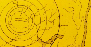
This is when it started getting exciting. We soon had a flash; all of a sudden we saw what had happened, and that was a genuine epiphany. We will be back next Thursday with the solutions to these problems, but in the meantime we want you to have a chance to ponder them, and see if you can come up with the solution yourself. We leave you with a blown-up version of our map, focusing on the southern part of the Roosevelt Delta. Take a good look

  Do you have some ideas? That is , before you read the second column – just below.

Close-up of the southern delta.


       The Hyde Park Deltas – Part two

thecatskillgeologist.com

Robert and Johanna Titus

March 2016 revised version

_____

This is the second of two new articles about the Hyde Park deltas.


   Last time, we began investigating the Hyde Park Deltas. These ice age features have been recognized by glacial geologists for decades and they are seen on the New York State Museum’s map of New York State glacial geology. That map recognizes two deltas.  But we have found something remarkable and, we feel, revealing. Those two deltas represent two chapters of delta formation. That needs to be explained. So – we are going to, herein, record the sequence of events that we have deduced to, we hope, explain all this. We are, in short, going to record a sequential history of the formation of the Hyde Park Deltas – and thus Hyde Park itself.

1) It all began sometime close to the end of the Ice Age. The Hudson Valley glacier had been melting and vacating the valley, and it left behind a sizable lake. That has long been recognized as Glacial Lake Albany. The lake stretched across the Hudson Valley and, at Hyde Park, it was nearly two miles wide.

   2) Crum Elbow Creek was flowing south by southwest, east of, and parallel to, the lake. This took it across a newly deglaciated landscape. We suspect that, at least at first, it was a far more powerful stream than it is today. It does not amount to much today, but back then, it may have been swollen with very dirty meltwater. It, we think, it (must) have been a very erosive stream.


Crum Elbow Creek today, upstream.


3)  If so, then Crum Elbow Creek had to have carried a very substantial load of sediment which came to be deposited in Lake Albany. Most of that sediment formed what we are calling the Roosevelt Delta (see yellow on our map). The waters of Lake Albany, at that time, reached a level of 180 feet in modern elevation. The delta’s topset was, likewise, at today’s 180 feet.

The Hyde Park deltas; Roosevelt Delta in yellow; Vanderbilt Delta in brown.


4) We conclude that, back then, Crum Elbow Creek did not turn sharply to the west as it does today. Instead, it continued its southwest path which took it past today’s Wallace Center and onward, just a little north of the Roosevelt mansion, Springwood. Its old channel can still be seen adjacent to the parking lot at the Wallace Center (see map and see photo). This is the time when the stream deposited the Roosevelt Delta (again, see our map).

“Old” Crum Elbow Creek, highlighted in red. “New” Crum Elbow Creek (blue) extends off to the west.


Now dry channel of “Old” Crum Elbow Creek, just north of Wallace Center. “Old” Crum Elbow Creek once flowed at the bottom of this small valley.


   5) Next, there came a time when Lake Albany (suddenly?) drained down to a level of 170 feet. We do not know why, but with that lowering, a remarkable event ensued. A small stream, one that had just begun flowing along the northern edge of the Roosevelt Delta, became quite erosive and, by headward erosion, it worked its way up along that northern flank of the Roosevelt Delta. Stream piracy was now occurring. The path of this stream, “New” Crum Elbow Creek, can be followed along East Market Street (aka County Route 41). It can be seen that this stream had been erosive enough to cut down into the bedrock there (see our photo) and create something of a canyon.

East Market Road follows canyon of “New” Crum Elbow Creek. The creek is just out of sight on the far right; it presumably cut the steep slopes of this canyon.


6) With time, this growing creek would intersect “Old” Crum Elbow Creek and divert its waters into the present-day path of “New” Crum Elbow Creek.  Also, a new delta, our “Vanderbilt” Delta, began to form. This younger episode of delta building apparently did not last as long as the previous one, and the new delta never got to be as large as its predecessor. The old Roosevelt Delta leveled off at 180 feet; the new Vanderbilt one at 170.

7) During the period of stream piracy, “Old” Crum Elbow Creek continued flowing in its old path. But that path was about ten feet higher above the new level of Lake Albany. This higher level promoted active erosion of the “Old” Crum Elbow channel. This old channel is the one visible just north of the Wallace Center parking lot. More of the old channel can be traced through Hyde Park.


More channel of “Old” Crum Elbow Creek (left center) on the Yellow Trail at the Winnakee Nature Preserve, just north of Rte. 9.


8) After stream Piracy was complete, the “Old” Crum Elbow channel was left high and dry as is seen at the Wallace Center today (our photo, above). Another dry channel can be seen immediately north of the old Roosevelt family stables. (See our photo below). That had been a tributary of Old Crum Elbow Creek.

Dry canyon of a tributary of Old Crum Elbow Creek, just north of Roosevelt family stables on the Cove Trail.


Sometime later, Lake Albany dropped the remaining 170 feet, down to its present level. Today’s “New” Crum Elbow Creek came into its modern form by eroding those 170 feet. This is best seen where the bridge crosses the creek at the south end of the Vanderbilt Estate.


Crum Elbow Creek at the Vanderbilt Estate.

We believe that this history accounts for pretty much all the landscapes we see, today, at Hyde Park. It is an account that describes the very origins of Hyde Park itself and is thus a fascinating history. We invite you to tour the town and see the geologic sites that we describe here. Then, take Rte. 9, north and south of Hyde Park, and see what the vicinity would have looked like if the deltas had never formed.

We have long been impressed with how ice age events explain so much of what we see in our scenic Hudson Valley. This is a fine example.

Elephant’s Graveyard – 3-2-17

in Uncategorized by

Elephant’s Graveyard

The Greenville Press

Oct. 3, 2002

Updated by Robert and Johanna Titus

randjtitus@prodigy.net


   The Hyde Park Mastodon on display at Paleontological Research Association in Ithaca


In recent years there has been a small flurry of discoveries of ice age elephants in New York State. You may well have read about the mastodon discovered in Hyde Park; it made quite a stir down there. The bones were found quite by accident in a small pond in the family’s backyard. All they had wanted was to enlarge that pond, what they got was an ice age treasure. Researchers spent the summer of the year 2000 excavating the skeleton and most of it was recovered. Such events are very exciting and people come from all over to see the bones as they emerge from the muds. Some even got involved in the project, there is never a shortage of local volunteers to help out in this sort of dig.

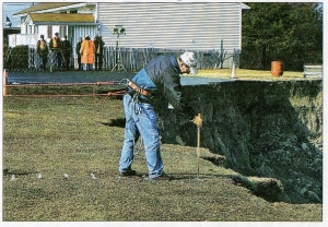
Excavation of farm pond

Less well known was a similar discovery near Ithaca, the year before. Another swampy area yielded the bones of an ice age elephant. This one were parts of a woolly mammoth, and this dig attracted dozens of Cornell students. A big surprise awaited them when, during the excavation, the remains of a second skeleton, this one being another mastodon, came to light. You can imagine the excitement that accompanied this “twofer.”

Such discoveries are always big news stories in the local area. They should be; they are rare and exciting events. But, during the eighteenth and nineteenth centuries very many more such discoveries were made. In those times it was common for farmers to drain their swamplands and this frequently led to the discovery of large bones. The Hudson Valley of New York State became something of a world capital for mastodons, as these relatives of the modern elephant were apparently very common here, especially in Orange County in the lower Hudson Valley.

Excavating mastodons in Orange County in early 1800s

Painting by Charles Wilson Peale


The hunting has not been nearly as good in the upper Hudson Valley, but some very historic finds have been made there. What may surprise you, as it did us, is that Columbia County was the very first place where a mastodon was ever found.  This story takes us all the way back to the year 1705. That’s when a mastodon tooth was found by a Dutch tenant farmer in what was then called Claverack Manor, which may well be Greenport today. Spring floods washed it out of a bluff, about 60 feet above the Hudson River. The remains were fragmentary, but they impressed the English colonists of the time. The big find was a tooth that weighed five pounds.

Today, such a tooth would be quickly identified as belonging to a mastodon, but back then nobody knew of such animals. There was great debate over just exactly what kind of creature had possessed such a large tooth. Lord Cornbury, then the English governor of New York, pronounced it to be from a human giant. His interpretation was greatly influenced by his religion. Genesis stated that there “were giants on the Earth in those days” and Cornbury thought this had been one of them. He sent people to search the site again and soon a fair number of very decayed bone fragments were discovered to go with the tooth. The corpse appeared to have been 30 feet long. A single thigh bone seemed to measure 17 feet. Those numbers were badly in error.

There were others who thought that the remains must belong some sort of animal or even a fish, but they could not tell just what kind. Congregationalist minister Edward Taylor was the first to suggest that the animal had been an elephant. But what kind of elephant? Back in the early 1700s nobody understood the concept of extinction and so nobody was going to suggest that the Claverack Giant was anything other than a modern form and there are, of course, no living wild elephants in New York State

Edward Taylor had other ideas however. He thought that there might have been some thoroughly un-Christian giants. He cited Indian legends of ancient human giants. They had been as tall as trees and hunted bears. But, to profess pagan Indian myths was not wise in eighteenth century New England, and these views were best kept to himself.

In 1706 some more mastodon remains were found and these were shown to Massachusetts Governor Dudley. He thought that they were the eyeteeth of a human, and he added the notion that the specimen had been a victim of Noah’s great deluge! His acquaintance, the influential Puritan Cotton Mather, of Witch Trial fame, embraced this notion enthusiastically. Despite his association with witch trials, Mather was something of a naturalist and, in his theology, he sought to focus on scientific rationalism. He saw the Claverack giant as empirical proof of the Biblical story that there had been giants living in the pre Deluge Earth.

It is true that there are some resemblances between the human molar and the mastodon’s tooth and, back then, little was known of fossil elephants, but Dudley’s opinion is still just a little hard to understand. As the decades passed, other mastodons were found from time to time.

Dudley’s speculations had long faded into history by 1838 when parts of another mastodon were found across the Hudson River in Greenville. This was, at the time, considered an important discovery. New York’s famous paleontologist, James Hall, brought along the even more famous English geologist, Charles Lyell, to visit the site in 1841.

It wasn’t long before another mastodon turned up in Greenville. A partial skeleton was found somewhere along Rte. 32, maybe about a mile south of Greenville. This was within a “small swampy depression” on the farm of Charles Coonley. It is not clear exactly what was found here and the bones seem to have become scattered, but it appears that a number of bones, perhaps from several elephants, came to light. This was long before careful excavations were done and so this discovery will probably never be well understood.

A few more Hudson Valley mastodons would come to light during the next 160 years, and we still think that there are more waiting to be found. These discoveries have been made mostly in the sediments of old glacial lakes and there were a lot of those in the Hudson Valley, in fact most of the valley was once a single great glacial lake, called Lake Albany.

After the Ice Age ended, those lakes generally drained, and a large number of pools and wetlands were left behind. If you travel around the Hudson Valley area you will see these in abundance. Some of those wetlands have been dammed to create artificial ponds, but many of the pools and all of the swamps are natural.

As the glaciers melted, forests gradually invaded our vicinity. The forests attracted mastodons. These animals fed on the vegetation and apparently enjoyed living among the trees. Mastodon teeth seem adapted for gnawing such foliage. Mammoths, on the other hand, were apparently better fitted for life on the bleak and barren tundras. They would have avoided forests. The whole post ice age Hudson valley was forested and populated by many mastodons but probably no mammoths.

We must do a lot of speculation as we consider the skeletons that have been found. The typical fossil mastodon is a young bull. Young males of most species are reckless and foolish so it is so easy to imagine many of them wandering out into small ponds in a quest for pond weeds. The sticky muds at the bottoms of these ponds seem to have trapped many of these poor creatures Elephants are bright animals, but they don’t rescue each other. Getting stuck would have led to a likely death and eventual preservation as a fossil skeleton in the pond sediments. As the millennia passed, the ponds turned into swamps and, in time, some of the skeletons were discovered. People dredged their swamps with the purpose of creating farm ponds and encountered the sleeping giants of long ago.


    Skeleton of mastodon buried in ice age lake deposit.

What we find so interesting about all this is that everything we know about this tells us that there are still a lot of undiscovered mastodon skeletons around here. Any swamp or pool of water is a potential hiding place for a mastodon, and there are a lot of swamps and pools.  And make no mistake about it, a lot of mastodons died in a lot of those old ponds. They are still there to be found.

Finding a mastodon is not easy, it requires luck, but it also requires that people know what to look for. Typically, somebody needs to make an excavation and that work cuts into the old muds. Large bones are found, but too often people dismiss them as being cow or horse in origin. It’s often the case that the significance of such discoveries is only understood when the tusks of the mastodon are found. It’s pretty hard to confuse tusks with the remains of a cow!

So, what we are saying is that if you have seen some large bones in a local excavation, it is time to take another look, you might have found the bones of an ice age mastodon and that should be known about. Good skeletons are worth a lot of money too. We are told that a complete skeleton is worth about $50,000. We are also told that it costs a lot to properly excavate one: you guessed it, about $50,000.

If you want to learn more about the history of American fossil mastodons, please read the book “American Monster” by Paul Semonin.


The Birth of Manorkill Falls 2-23-17

in Uncategorized by

The birth of Manorkill Falls

Windows Through Time

Robert Titus

Columbia Greene Media

Nov. 4, 2010


A lot of our Catskills landscape is owned by the New York City reservoir system and is administered by the city’s Department of Environmental Protection (DEP).  You can pretty much always tell where these lands are; the roadsides are festooned with no admittance signs. They will let you in if you have a proper fishing permit but, if you don’t, they will chase you away. I should know! But, even if most of us cannot get in, not everything is out of sight. One good example is Manorkill Falls. It’s located on DEP property, but it is still visible from the highway (Schoharie County 39, AKA the Prattsville Road). A highway bridge crosses the Manor Kill itself and you can park, walk out on it and see the falls. The upper falls are visible on the upstream side and, just below the bridge, and almost out of sight, are the lower falls.


The local stratigraphy accounts for the two falls, or so it would seem. They tumble over sturdy and resistant sandstone ledges. But, when I visited, I thought there must be more to it than that.  I looked at the upper falls, then crossed the road, looked down and to the west. I pondered the origins of these falls. When a scientist is faced with a problem and spends some time thinking about it, then he or she is likely to come up with possible solutions. We call these potential solutions “hypotheses.” That’s a fancy name for educated guessing, but it is an important step in the “scientific method” of problem solving.

Off to the west was the Schoharie Reservoir and it lies quite some distance below the falls. I wondered about that as I began to do some serious hypothesizing. I knew that there had once, long ago, been a sizable glacier down there. In my mind’s eye I could see it. It had slowly advanced south from the Mohawk River Valley and filled the entire Schoharie Creek valley, passing through Middleburgh and Blenheim. From there it would continue past Prattsville, almost reaching Hunter. That’s a lot of ice and a big glacier. I was watching it passing north to south, which was my right to left.

What a vision I witnessed! The glacier was mostly gray except where fresh snow lay. It was fractured by great curved crevasses, all of them reflecting the stresses that build up within brittle ice as it moves forward. Above it, the hills were bare; there were no forests in this ice age vista. My vision was a brief one, when I looked again, it was autumn and the season’s dense foliage displayed its rich leaf colors. It was the very same view but at a very different moment in time. Geologists are such sightseers!

This large Schoharie Valley glacier would certainly have been a very erosive phenomenon. It must have, as it advanced, cut into the Schoharie Valley floor, deepening it and widening it. I realized that this would give me some more help in my effort to explain Manorkill Falls. I looked west once again and, in my mind’s eye, I watched that glacier more carefully, as it slowly passed before me. It was, indeed, erosive and it did work to carve the sizable valley that eventually would form the basin of the Schoharie Reservoir. As such a glacial valley, it was, in fact, steep walled and deep. That helped me some more. I looked to the west and saw that deep valley under the waters of the modern reservoir. Then I turned east again, returned into the past, and saw a post ice age stream emerging from that direction. That stream would have been forced to tumble down the steep valley walls to get to the bottom of old Schoharie Creek Valley. I was looking at the earliest origins of Manorkill Falls.

Now I put together a more complete story. That Schoharie glacier had first advanced down the valley. It deepened and widened it, but mostly made its slopes steep. The ice filled the valley for a very long time but, eventually, the climate warmed and the ice began to melt back to the north. A sizable lake replaced the glacier. Its waters filled the valley, matching in so many ways the view of the reservoir, the one we see in modern times. That old lake must have been ten time larger than the modern reservoir!

It was about then that Manorkill Creek came to be born. That creek began to flow out of the valley to the east and it was forced to tumble down the newly formed steep slopes of the greater valley. Today’s canyon, behind Manorkill Falls, is deep and speaks of a very strong flow of water, way back then. You can see it as you drive east toward Conesville on Rte. 990 V. I pulled over and got out. I watched, and felt, the flow rising in this canyon. Soon it was a far more powerful and even thunderous flow than we see today. Raging, foaming, pounding torrents raced by. Below all that whitewater, the flow was carving the modern canyon. I, the geologist, had been privileged to go and see its birth. You can go there and do the same.

Reach the author at titusr@hartwick.edu. Join his facebook page “The Catskill Geologist.”

Dam Concerned Citizens: another form of protest. 2-16-17

in Uncategorized by

A Different Kind of Protest

On the Rocks

Robert and Johanna Titus

The Woodstock Times

Jan. 22, 2015


Perhaps you have read the news of the recent rehabilitation of the Gilboa Dam at the Schoharie Reservoir near the village of Gilboa. The city of New York, which owns the dam, has been spending hundreds of millions of dollars to upgrade its structure and to render it ready to survive any potential future flood events. It is said that the dam is now engineered to endure a flood two and one half times worse than the one it survived during Hurricane Irene, just a few years ago. That’s a big win for a local civic group named “Dammed Concerned Citizens” (DCC). But, it is also a big win for New York City. That’s our story today.

This story began about ten years ago when an engineering report found that the dam did not meet “. . . safety standards associated with modern engineering practices . . . “. These understated words set off alarms. People were aware that there had been a surprisingly large number of “hundred year” floods in the recent past. Such floods had struck in 1955, 1987, and 1996. Now they feared that the impact of one more awful flood would cause the dam to lurch forward, just a bit, and then give way altogether.  The threat was truly frightening; after all, almost 20 billion gallons of water were pressing against the aged dam. People couldn’t help but to imagine the dam fracturing and breaking up, as masses of water burst through it, and exploding into the valley below. The result of such a total destruction would be a tsunami, rushing for hours down the Schoharie Creek Valley. The horrible wave would pass across Middleburgh and then Schoharie. It would continue into the Mohawk River Valley and then turn east, heading for Schenectady. It was estimated that some 8,000 people might lie in the path of this deluge. Read all that again – slowly –  and just think about it for a moment!

The Gilboa Dam had been constructed during the 1920’s, so it was, by then, a little more than 80 years old. It was, reportedly, designed to last only 50, so it was old. Below the dam, the spillway had seriously deteriorated, with holes eroded into its cement by decades of plunging waters. The bedrock beneath was cut by numerous fractures. The face of the dam itself had been weathering, over all those decades, until it was reported that about seven percent of the original structure had been eroded away. It all looked unstable; it all looked dangerous; it was, all of it, neglected.

The long and the short of it was that any sizable flood might take out the whole dam and result in thousands of horrible deaths. It was estimated that if waters rose to 1,138 feet in elevation, then the pressure would be so great that the dam might just let go.  Dam Concerned Citizens was damned concerned!

Imagine for a moment that we are talking about an old dam, and an old reservoir that lies along the Saw Kill, a bit upstream from your Woodstock, How would you react? We monitored some of the internet chat about all this and found a lot of people felt vehemently that the Gilboa Dam should just be drained and shut down. Close it and be done with it! We are guessing that a lot of you would band together to form something called CDD, “Close the Damned Dam.”

But the people of Schoharie County are not like that. They took a more pragmatic approach. It was not reasonable to demand a closing of the dam. There would be no “occupy Gilboa” here. They would come up with a different sort of protest, a softer, quieter, but unrelenting protest. They aimed at an achievable goal, of infrastructure improvement, aimed at maximizing the safety of the dam.  They knew how important New York City is to the whole of the state and its economy. And they rather thought it would be better to fix the dam than close it. A closed dam would benefit them, but a fixed dam would help everybody.

But they were under no illusions; they faced very serious hazards, and they understood that fact. Lives were, after all, at stake.  Dam Concerned Citizens went to work. They opened a website, which became a public advocate on issues of regional dam safety. For these reasons, they recruited experts on dam engineering and stream flow. They never confronted New York City or its Department of Environmental Protection (DEP), but always kept up a conversation. They quietly, even softly, maintained a pressure to get things going. And they continuously monitored what was going on. Their experts were always quite able to judge whether or not things were being done right.

We, who drive by the dam frequently, began to notice that things were happening. A five foot deep notch was cut into the top of the dam; it would make it very hard for water to rise to that fearsome 1,138 foot level. Siphons appeared; they would drain the dam if things got dicey. Importantly, time had been purchased. Later the dam face was worked on and restored to a youthful appearance – and function. The dam was being fixed. And DCC was closely following the progress.

Gilboa was far enough along, so that when Hurricane Irene struck in August of 2011, it held. There were, indeed, very frightening moments on that very frightening day, but the dam stood firm. Since then, it has only gotten better. And, just recently, the dam has been declared safe. An observance was held, and waters from the reservoir were ceremonially poured onto the dam face. Members of DCC were present.

It could have been so different. DCC could have dug in its heels, resolving to shut down the dam and its reservoir. And maybe they could have pulled it off. But that would have deprived New York City of one of its major sources of fresh clean water. What would have resulted from that? It is probably very good that we will not find out. But there is something else. The city is world famous for the high quality of its water and it is from the Catskills that most of it is derived. Catskill residents take quiet pride in being the source of that water. They want that to continue; they are good neighbors.

We won’t be subtle in stating that the two of us support everything that DCC has done. But, there are lessons to be learned here: First, it is better for parties, with problems like this, to work together. More importantly, it is even better to have a can-do attitude, and to work to solve those problems in a way where both sides come out winners.  Perhaps Schoharie County residents could have been the sole winners – had they really wanted that. But they resolved to find a different kind of protest.

Contact the authors at randjtitus@prodigy.net. Join their Facebook page “The Catskill Geologist”


The stream at the top of Kaaterskill Falls 2-9-17

in Uncategorized by

Top of the falls, bottom of the river

Windows through time

Robert Titus


Kaaterskill Falls is one of the scenic centerpieces of the Catskills. To stand atop these falls and to gaze out at the gorge below is a grand Catskills experience. The stream which makes the falls can, at times, be a powerful flow. This is the creek that drains North and South Lakes so it witnesses a lot of water flowing by. Sometimes it is a thunderous and very loud flow that tumbles over the falls. That adds to the experience. People have been coming here for almost two centuries now. Many have left the names or initials carved in the rocks here. The oldest inscription in the rocks that I have seen carries the date of 1810. Thomas Cole did some of his early work here.

But I am a geologist and when I am at the top of the falls, which is often, I see inscriptions that Nature herself has left here. And these are a lot older, hundreds of millions of years older. I know how to read those inscriptions even though they are not in English.  And when I read the rocks I see into them. I see not just one stream here but two. And both of those streams are flowing in the same direction and their two channels are almost identical in size. Left banks match left banks; right banks match right banks. But that second stream is as old as the rocks themselves, perhaps 375 million years old. You might dismiss my observations as tainted by hallucinations but I am quite literal in what I report to you. There are two streams there. Let me explain.

If you visit the top of Kaaterskill Falls please notice the rock ledge that rises above the modern flow of water. Notice the stratification within those rocks. Beds of sandstone lay there, all of them inclined in the direction of the falls. These sandstone beds and their patterns of stratification make what is called planar cross bedding. That is a sedimentary feature which we associate with the channels of rivers. Essentially, these strata were part of a sand dune which formed within the channel of the old stream and grew with time as it also migrated down the stream.

Aha! Now you too can see my second stream; it is composed of rock. Planar cross stratification occurs when powerful river currents are sweeping sand along in a downstream direction. As long as the current stays strong the sand will continue on its journey. But, just as the current is starting to slow down which has to occur eventually, then deposition begins. The sand slows down too and that dune begins to form and then it grows one stratum at a time. That growth continues the dunes migration as it is now growing in a downstream direction. Look carefully and that is what you can see here. Those strata of rock are inclined to the right which is roughly to the southwest. That’s the direction that the old stream was flowing. And, it is also roughly the direction that the modern stream is flowing.

What happened to that sand and its dune is that it finally stopped advancing downstream and never moved again. The stream was probably diverted to a new path, rivers do that. Then, with time, the sands came to be buried under so much more sediment that they were hardened into rocks. This became a petrified dune in a petrified streambed.

And so it is that I really do see two streams here. One is modern, the other is very ancient. Both display the same direction of flow, to the southwest. It is so odd to see two streams, so similar to each other but separately by hundreds of millions of years. But it is the nature of my science of geology to discover such things.

   Kaaterskill Falls is a wondrous place, but it can be a dangerous place too; a number of people have fallen to their deaths at Kaaterskill Falls, you must be careful there. Wait for dry and warm times before you visit. Contact the author at titusr@hartwick.edu  or visit the facebook page “The Catskill Geologist.”

Tilted strata 2-2-17

in Uncategorized by

Tilted Strata

Windows Through Time

Robert Titus


This column is focused on allowing you to see things that have always been right there in front of you. That’s something we geologists are good at. We travel to outcroppings of rock and look into them and see things that we never saw before. We survey landscapes and find meanings in them that we could never before have perceived. That is the nature of a geologist’s life; we are always looking through those windows through time and we are always seeing such wondrous visions, visions of the past.

Let’s take a drive down Rte. 23 near Leeds and see what we can see. Where Rte. 23B enters onto Rte. 23 there is a very fine outcrop. The strata here are of the Helderberg Limestone. This is pretty much the same rock sequence that makes up the cliff at John Boyd Thacher State Park. It is limestone and that means it formed at the bottom of a very shallow tropical sea. I can’t drive past these rocks without seeing images of the Bahamas. I find myself snorkeling in that beautiful sea.

                 Tilted strata along Rte. 23 near Leeds.

   But there is something else, and you have to look twice and think about it before you take notice. All those strata are tilted.  Take a look at my picture. Those strata tilt steeply to the right. That’s just exactly the sort of thing that people don’t normally notice. You do have to think about it to appreciate it. Strata form, originally, on the flat bottoms of the ocean. The seafloor never dips on one direction steeply as we see here. Something must have happened to these rocks.

Geologists recognize a concept called the “principle of original horizontality.” Simply stated that means that seafloors are flat and, because of that, strata accumulating upon them must also be flat. But what if they aren’t? Then we have to figure out what happened to them. Tilting is a good word, a verb which implies that the once flat strata have come to be tilted from the horizontal. But how on earth could that have happened?  Stop and think about it. Those rocks are heavy, very heavy. How could they have ever have become tilted. One end of the outcrop must have been lifted, and how on earth can such a thing happen?

Now you see what is happening. We have stopped and actually looked at an outcrop and all of a sudden we have a lot of very interesting questions. It was about 300 years ago that early geologists first paid attention to this sort of thing and you can just imagine how perplexed they must have been. What could have caused such phenomena? Back then, they could not even guess.

Today, it’s different. We have scientific theories to explain such things. Today we understand a lot about what is called mountain building. We can look to the east and we recognize that once, long ago, something collided with North America. That collision squeezed the rocks throughout what we call the Appalachian realm. The compressed rocks acted like the folds of an accordion; they were squeezed and deformed just as an accordion is.  A lot of that deformation consisted of simple tilting of the sort we see here.

That something that collided with North America was essentially a very large portion of Europe. Just as India is, today, colliding with Asia, once Europe collided with North America. When you stop and think about that, then you can appreciate that this sort of thing is capable of lifting and tilting such enormous masses of rock. This is big time geology. This is mountain building and that makes it important.

But, you might ask, where are those mountains? The answer to that question makes this outcrop still more interesting. Look up into the air above it – thousands of feet up – actually a mile or so. There used to be mountains up there; they have all eroded away.

Now it is fitting to take a few steps back and look, now more deeply, into this outcropping. Using your mind’s eye you can see the aqua colored waters of an ancient tropical sea. Then you watch as thousands of feet of sediment pile up upon this site. Slowly those sediments petrify; they become brittle masses of rock. Then, the ground starts lurching and rising to form a great range of mountains. The old ocean quickly drains away. Those mountains reach great elevations and tower above the horizon. Now wrenching motions are contorting the strata within; this is the chapter which witnesses the tilting we first came here to ponder.

Then all becomes silent; the mountain building is over. For millions upon millions of years the old mountains slowly decompose; they weather and erode away. Eventually, they build a highway here.

Contact the author at titusr@hartwick.edu or find visit his facebook page “The Catskill Geologist.”


Seeing a lake that is not there. 1-26-17

in Uncategorized by

Lake Front Property

Windows Through Time

Robert Titus

June 24, 2010


Intersection of Rtes. 32 and 23A

When you have been a geologist for a long time you develop a real sense for the landscape; you gain insight and you just plain notice things that others don’t. With age and experience, you become an increasingly effective observer in the field. In many sciences it is the very young who do the best work. In my science, however, the most seasoned eye often sees the most and the best.

There is one thing, however, that even the most experienced eye finds difficult, and that is seeing what is not there. That happens when Nature has painted a landscape but left something out. If you can notice the absence, you may be awakened to some wonderful moment in the geological past. But, just how do you see what is not there? Well, as I said, it comes with age and experience. And for you that starts right now; give me just a few minutes.

Let’s go to the intersection of State Routes 32 and 23A, just east of Palenville. Look to the northeast and see what you don’t see. There is a fine agricultural field, but what else can you see? The answer is not much. There are no canyons, rivers, no hills nor dales. In fact, there is just about nothing there. I have been by there many a time and I have long noticed that I wasn’t noticing much in the way of real landscape, just a lot of flatness. Well, all along, I did have some interesting ideas. I finally looked it all up in the geological literature and confirmed what I had suspected all along.

This broad flat landscape, so well suited for the farmer’s plow, is sometimes known as the “Kiskatom Flats.” As I expected, the flats mark the floor of an Ice Age lake. The story of this lake takes us back to about 13,000 years ago when warming climates were bringing the late Ice Age to a fitful end. At that moment the Kiskatom flats were something you might call a glacial battlefield. The ice had, earlier, retreated halfway to Albany. Then the climate cooled briefly and the ice re-advanced to the southern end of these flats. That readvance was temporary, and the ice was once again melting away, this time for good.

As the ice left the area, a landscape depression was left behind. With all the meltwater that is produced by retreating ice, this depression filled up quickly and hence the origin of Glacial Lake Kiskatom. The lake waters rose to an elevation of about 360 feet, and my guess is that it was four miles long, north to south, and one mile wide, east to west.

It must have been quite a sight. On its northern shore there was still a great glacier, rising perhaps a few hundred feet above the lake waters. All along the eastern shore there was likely an equally thick glacier. This was the end of the Ice Age and the temperatures were quite warm. All of the ice was actively melting and vast volumes of meltwater were pouring out of the valley glacier. Imagine thundering cascades of raging foaming white water plunging into the lake.

These glaciers were not melting so much as they were disintegrating. From time to time, enormous masses of ice would have detached and crashed down into the lake, breaking into numerous small icebergs. Believe it or not, huge tidal waves would soon have rippled back and forth across the little lake; such things do occur in small lakes.

But what about that flat landscape? These are common throughout the Hudson Valley and into the valleys of the Catskills. As a veteran geologist, I am always on the lookout for them. It has been my experience that these almost always mark the locations of other old glacial lakes. What happens is that the meltwater is dirty with sediment which quickly accumulates as flat stratified sheets on the floor of the lake. Much later, after all of the water has drained away, the flat lake bottom becomes a wetland which slowly dries out into a flat field. The northeast corner of Kiskatom Flats is still a wetland.

There are similar flats along the eastern banks of the Hudson River, that’s Glacial Lake Albany. There is another large flat area in the Schoharie Creek Valley, that’s Glacial Lake Schoharie. And there are more; you can start watching for them. Having just spent five minutes reading this article, you are more experienced and have a better trained eye. It’s time for you to start noticing such things. Go to Kiskatom Flats and see the lake with its bergs, look at the glaciers to the north and east and watch the raging cascades of water. You are seeing what is not there!

Reach the author at titusr@hartwick.edu or find his facebook page “The Catskill Geologist.”

Kaaterskill Clove from the air 1-19-17

in Uncategorized by

Kaaterskill Clove by air

Windows Through Time

Robert Titus

Columbia-Greene Media, Dec. 31, 2009


Recently this blog visited Hyde Park and found that the whole town is a heap of ice age sediment which was deposited as two deltas within Glacial Lake Albany by an ancient version of Crum Elbow Creek, the stream that flows right through the Vanderbilt Estate in the middle of town. This week, let’s visit something very much akin to this on the other side of the Hudson Valley.

Let’s visit the town of Palenville, which is found at the very base of Kaaterskill Clove. Recently, I had the chance to do it by air. My wife and I live next to the Freehold Airport operated, by the Nutmeg Soaring Association, a glider club. I managed to bum a ride into the Catskills. You can see a lot up there and much of it is invisible from the ground.

Kaaterskill Clove with Palenville alluvial fan  below it.


Palenville is one of those Catskill towns with an extensive historical heritage. It has been a place where visitors have long begun their ascent into scenic Kaaterskill Clove. Originally a tough trek, nowadays there is a modern highway so the journey is easy. In the 19th Century Palenville became an artist’s colony. Artists of the famed Hudson Valley School of art commonly spent their summers there and devoted themselves to sketching and painting the area’s scenic landscape.  A lot of very good work was done in the vicinity of the clove. Palenville has always seen a great number of tourists passing through on their ways to the mountains. Today hikers frequent the town.

Geologists have long been drawn to Kaaterskill clove to view its landscape with a more scientific eye. That’s where I fit in to the story.  I love to hike the clove and the mountains north and south of it. There is an awful lot of very good geology to be seen here. So, when I got the chance to fly over it, I welcomed the opportunity. I had a pretty good idea of what I would see and I looked forward to it. Kaaterskill Clove is a great gash in the Catskill Front. Most of it was carved during the Ice Age, especially during the closing phases of that time. Melting glaciers provided enormous amounts of water that cascaded down the canyon, eroding it. Think of it as an oversized gulley!

Kaaterskill Clove had been there before our most recent ice age. It probably began eroding at the end of a previous ice age chapter. But about 13,000 or 14,000 thousand years ago there was another time of melting . . . and another time of erosion. You have to visit the clove and imagine it with deafening masses of raging, foaming, pounding whitewater thundering down its canyon. Erosion would have been going on at an alarming rate.

Where there is erosion, the destruction of rock, then there must also be the production of equally large masses of sediment.  Rock is converted into sediment on a nearly one-to-one basis. The newly formed sediment must be deposited somewhere. That is exactly what I was going to see.

Palenville has long been recognized as something that is called an “alluvial fan.” That is a large, fan-shaped heap of earth. The earth of an alluvial fan spreads out across a dry valley floor at the bottom of the sediment’s source. In this case, large amounts of sediment traveled down an eroding Kaaterskill Clove and then spread out into a fan shape heap at the bottom of that clove.  There was no ice age lake in Palenville so no delta formed here as did at Hyde Park and that is why an alluvial fan is different. It has no flat top as does a delta; it is all slow, gentle slopes.

Map of Palenville alluvial fan.

A trained geologist can recognize such a feature on any good topographical map, and I did this a long time ago. But now, I was up in a plane, and there it was.  As we flew by I gazed into the great wide yawning clove. And spread out before it was the alluvial fan.  I could recognize three roads that I knew. These were Bogart Road, Rt. 23A, and Rt. 32A. The three of them radiated out from the bottom of the canyon and spread out across the top of the fan. Nobody knew it at the time but as laid out those roads all descend the gentle slopes of the alluvial fan.

So, in recent months we have visited two piles of sand, both deposited at the end of the Ice Age. Each fostered the appearance of a town. It is strange how often we humans live upon ice age sediments. It happened so long ago, but it reaches forward through time to affect us. Reach the author at titusr@hartwick.edu and see more at our facebook page “The Catskill Geologist”


A visit to a drumlin field 1-12-17

in Uncategorized by

Drumlins: pretty little hills

Windows Through Time

Robert Titus

Sept. 10, 2010 in Columbia Greene Media


I would like to introduce you to a new geological topic today, one which is very important throughout the Hudson Valley. That is the drumlin. Drumlin is a Gaelic work for hill, but these are very special hills with very special origins. Hills come in all shapes and sizes; they are found everywhere. What makes a drumlin different is its particular shape and the particular type of place where it is found.

A drumlin is said to have the shape of an upside down spoon bowl, so we can start by having you take out a typical spoon, turning it over, and looking at it from what would normally be below. You will see a very nice symmetrical oval shape to the spoon bowl. It is wider at the handle end and tapers to a narrow front. Now turn your spoon sideways, but still upside down and look at it from this angle. The handle end is steep but the angle, again, tapers towards the front.

       A teaspoon bowl, shaped like an upside down drumlin.

   These are exactly the forms we see in a drumlin; you just have to scale it all up in size  . . . a lot. Drumlins can be a mile long, up to 150 feet in height and they can be more than 1,500 feet wide. Most are a good bit smaller, but they are large. They are like potato chips; you can’t just have one. It is very unusual to just see one of them; typically they occur in drumlin fields where they can number in the scores and sometimes many more. And those drumlins fields are, as I said, only found in particular landscapes: areas that had been glaciated.


                                                                    A drumlin field, arrows show direction of glacial movement.

Drumlins display compass directions and those directions speak to us of their origins. Typically drumlins are parallel to each other, and parallel to the long ago flow of the glaciers that formed them. In the Hudson Valley they are commonly oriented north to south.

But how, exactly, did the glaciers form them? Late at night, in geology bars, that issue has been debated for decades. It is not easy to describe the origins of drumlins without using the word sculpting. It would seem that glaciers pass across large masses of coarse glacial sediment and sculpt those materials into the forms we see, but more explanation is needed. The big problem is that nobody has ever been to the bottom of a glacier that was sculpting a drumlin so we can’t go and observe the process.

It may be that drumlins formed late in the Ice Age, when the climate had been warming up. Water would melt out of the glacier and soak into the sediments below. That would make them soft and very pliable and speed up the sculpting process. But, again, nobody has been there to see this happen.

But, for our purposes, something that is very important is that drumlins are scenic and make for very nice landscape. Recognizing them is important to appreciating our Hudson Valley landscapes. You need to see one.

We will, in the future, visit a lot of drumlins and a number of drumlin fields, but today I would like to just recommend a visit to just one, a good one. That would be in the Hudson Valley Hamlet of Viewmonte, along the northern edge of Clermont. Take Rte. 9G south from the Rip Van Winkle Bridge about five miles. Watch on the left (east) for Cemetery Road. Take that left and, less than a mile down the road, you will see a cemetery on the right. If you are not careful you will pass by its inconspicuous entrance so watch it. Drive up that narrow driveway. You have not only entered a cemetery, but you have entered onto a drumlin and a very good one. You are driving up the north end of the hill and this is the steep side. When you reach the top, you will appreciate just how symmetrical a drumlin can be, Steep, but very smooth slopes, form the two, east and west, sides of the drumlin. At the back of the cemetery the driveway forms a turnaround and there you have reached the tapered downstream end of the hill.

                                                                          The top of the cemetery drumlin at Viewmonte

This is a very good drumlin; it has all the morphology that you would expect to see. Being a graveyard, the landscape has been kept open; there are few trees or shrubs to block the view. So this is a very good “introductory” drumlin. We will, in the future, see many more and we will learn about drumlin fields and see what they have to tell us about the ice age history of our region. They, if fact, have much to say.

Contact the author at titusr@hartwick.edu or visit his facebook page ’The Catskill Geologist.”

A moment on the bottom of an ancient sea floor. 1-5-17

in Uncategorized by

A few moments in time

Windows Through Time

Robert Titus


Like many paleontologists, I can well remember the first time I visited a dinosaur. My parents took me to the American Museum of Natural History in New York. There was the magnificent full skeleton of a Brontosaurus. I can remember looking up at it. I was about seven, so that beast looked pretty big to me. So too did a nearby Tyrannosaurus. It’s an experience that helped lead me, like many other youngsters, to a career in the study of fossils.


Every child should have a moment like this. But as an adult, I am often more impressed by things other than size. I am more philosophical now. Time means more to me now than back then; after all, I have known so much more of it. And one type of fossil that impresses me the most is called the trace fossil. That’s something you might well not be familiar with so let me explain. Most fossils, such as those towering dinosaur skeletons, are body fossils; they preserve parts of the original creatures. They are bones, shells or teeth and have lasted so long because they are composed of resilient materials. They are great fossils, but not the only kinds we see.

Trace fossils are different; these preserve the activities of ancient organisms. You can be forgiven if you ask how activities can be preserved in rocks. It does not seem intuitive, does it? But let’s begin with the best known of the trace fossils: the dinosaur footprints. They illustrate what I have in mind. The sizable three toed footprints of dinosaurs are actually quite common. The old monsters walked around in mud and left footprints which eventually petrified to make the most wonderful fossils. Walking is an activity and so these are trace fossils. There are quite a few locations where these can be seen in the Connecticut River Valley of Connecticut and Massachusetts. Someday I will describe one of them for you to go visit.

Dinosaur footprints from the Connecticut River Valley


But, what I have in mind are the traces of creatures that are a lot more modest. These fossils are so humble that they don’t even have a proper name. These are the traces of animals that burrowed across marine sediments almost 400 million years ago when our region was beneath the waves of the ancient Catskill Sea.

Take a look at my illustration and see what I am talking about. This is a slab of local sandstone. It is from near the top of an outcrop that lies along Rte. 23, just east of Five Mile Woods Road, just east of the town of Cairo. That outcrop was overrun by a glacier back during the Ice Age, and that glacier polished this surface, bringing those traces into sharp detail. This sandstone was once lying upon the bottom of the sea and that seafloor was alive with living creatures. Often I see the shells of ancient invertebrates on such sandstones, and a number of such fossils have been found at this outcrop.

            The burrows on Rte. 23

Notice the back and forth motion displayed with these traces. Some sort of creature was moving in this fashion, probably right on the floor of the old sea. There is a series of small “wiggles” inside of the larger ones (the third photo). This is pretty complex behavior from what must have been small and simple animals. These lines are the traces. Once, long ago, some sort of a simple invertebrate animal was mucking about across the sediment at the bottom of that sea. Today, lot’s of animals live in this sort of habitat. They dig across the mud. They actually travel, and in so doing, they leave their burrow traces behind.

Close up of same burrows

What kind of animal was it? I don’t know. If you force me to answer the question I would first guess that it was some sort of a worm, but I really don’t know. Some of our readers have observed snails producing these sort of movements. Where was this creature going? Here I can only guess that it was just wandering and it did not know itself where it was going. Worms and snails don’t carry maps you know; they have no idea where they are going.

What was this creature doing? Here I can come up with a reasonable answer: it was very likely looking for food. That’s the motivation for a lot of animal activity. It is even possible that, if it was a worm, then it was eating the very mud it was digging through. Modern earthworms do that and there is no reason to suppose and ancient worms did not. Snails make these motions as they scrape algae off of the sea floor.

In the end, however, what is so remarkable about this fossil is how ordinary it is. This is not the skeleton of a towering dinosaur; it only records the very existence of a humble invertebrate animal; there was nothing remarkable about what that creature was doing. It was simply going about its daily routine on the floor of an ancient sea. It is the extraordinarily everyday nature of this that makes it of note. When we look at this fossil we are sharing a few minutes or so in the life of an invertebrate animal. I find that astonishing. Contact the author at titusr@hartwick.edu or find more at the facebook page “The Catskill Geologist.”


Go to Top