"I will never kick a rock"

Manorkill Falls – June 29, 2023

in Uncategorized by

The Depths (?) of a sea,

The Catskill geologists,

The Mountain Eagle, Dec. 1, 2017

Robert and Johanna Titus


Have you ever been to Manor Kill Falls? You take Rte. 30 to where it intersects Rte. 990-V and then you head north a few miles and then watch for the signs. They have a fine parking lot and then you have a choice of trails. The upper trail heads for the top of the falls, but we want you to take the lower trail. That one takes you down to the bottom of the falls where you get a fine scenic look at it. That’s where the best geology is too.

You stand at a good location and look up at the falls. If you have an eye for rock types then you will recognize a sequence composed mostly of thinly bedded black shales. These strata are interrupted with the occasional dark sandstone. That’s a good start but now you need to get a better look at these rocks. You can do that by looking down; the ground is littered with rocks. A thin “shingle” of black shale will reveal a very fine-grained sedimentary rock; it is composed of silt and clay. None of those grains are large enough to be seen. It is black from all the organic matter in it – the stuff of ancient life.

It is natural for a geologist to begin looking for fossils. Those provide the clues for figuring out exactly what kind of environment is represented here. The hunting was disappointing at first but, after a short while, the fossils of some shellfish were turned up. These were creatures called brachiopods. Like clams, they have two shells, and like clams, they spent all of their lives lying on the seafloor. But they are not clams; they have a very different anatomy, so different that they are not even distant cousins of clams.

Nevertheless, these brachiopods are marine animals, and they tell us that all the strata we are looking at were formed, about 390 million years ago, at the bottom of something that is often called the Catskill Sea. Stand back at look up again. Each horizon of stratified rock once took its turn being the floor of that ocean.

Well, now we know something important; The Manor Kill Falls location was once the bottom of a large ocean. The next question that comes to mind, to a geologist anyway, is “just how deep was this ocean?’ We can’t throw a plumb bob overboard so just how do we determine this important bit of information. The answer is that we don’t, we can’t. But we can make some approximations.

Here’s how we do that? We have already looked those lithologies over and we have found that most of the bedrock here is fine grained black shale. That’s a type of rock that forms in relatively deep waters. The black color speaks to us of a relative scarceness of oxygen on that sea floor. That black biologic material would have decayed away if there had been oxygen. We did not find many fossils so not too many shellfish lived down there.

We thought we were building a case for a very deep-sea environment, but then we found something else. That something else was downstream. There we saw a slab of rock covered with what are called ripple marks. Take a look at our photo. These are slightly asymmetrical ripples and that indicates that these were sculpted by currents passing across that sea floor. What does that mean? Ripples are rare in very deep waters. It means that this seafloor was not all that deep.

We stood on that slab; we were literally standing on the bottom of an ancient sea. We looked up and, in our mind’s eyes, we could see the dimness of just a little sunlight that had reached down to this seafloor. It just wasn’t that deep.

Contact the authors at randjtitus@prodigy.net. Join their facebook page “The Catskill Geologist.” Read their blogs at “thecatskillgeologist.com.”


A View Back Through Time, June 22, 2023

in Uncategorized by


An image of the past – the Schoharie Creek Valley

The Catskills Geologists. Mountain Eagle, 2017

Robert and Johanna Titus.


We love to drive around in the Catskills. There is always so much scenery to see.
Even at 55 miles per hour you can look and see so much, at least the passenger half of our marriage can. But sometimes – no frequently – we feel the need to stop and get out so that we can stand along the side of the road and just gaze – into the past. Let’s do that in this week’s column.

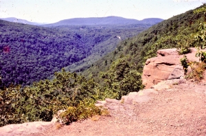
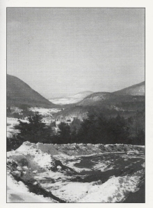
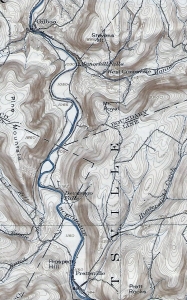
Our journey will take us to the Schoharie Valley, midway between Middleburgh and Schoharie itself. There we find a special sort of imagery. Take a look at our photo. We are looking east from Rte. 30. In the distance is a hill with the unlikely name of “Rundy Cup Mountain.” In the middle foreground is the valley floor of Schoharie Creek. It’s pretty, don’t you think? That valley floor is remarkably flat and that is important, but first let’s concern ourselves with Rundy Mountain. We want you to look again and notice something you might have missed the first time.

There are sharp boundaries between agricultural fields and forests on the slopes of
Rundy Cup Mountain. And those sharp boundaries define a nice curvature to the lower slopes of the mountain. There is not a trained geologist in the whole world who would not immediately see what we saw. We looked, and then turned around and looked west; we saw the same curvature on that side of the valley. That curvature defines what we call a U-shaped valley.

And that is the dead giveaway to the valley’s long ago history. A U-shaped valley, like this one, is always the product of a valley glacier. We looked again and, in our mind’s eyes, we gazed into the past and saw the Schoharie Creek Valley filled, almost to the top, with a glacier. Our mind’s eyes rose up into the sky and we looked down on it. We had returned to an episode of time, late in the Ice Age. We looked south, and we saw that glacier, confined by the valley walls, and moving like a river of ice, south through the valley. The white surface of the ice was fractured by great, dark, curved crevasses. These curvatures betrayed a southward motion to the ice.

We, the mind’s eyes, paused a full thousand feet above the ice. It was a warm day, by ice age standards. Meltwater, in abundance, had accumulated beneath the ice, and it was lubricating that southward motion. We hung in the air and listened; we heard creaks, and groans emanating from the moving ice below us. From time to time, great, explosive, cracking, echoing sounds followed. On this day the brittle ice was advancing at the almost unheard of pace of 100 feet per day!

It had been a clear ice age mid-June morning, but now it was late afternoon. The sun shined down directly on the ice and a thick ground fog had formed. The fog rose up and enveloped us; we could no longer see the glacier.

When the fog finally cleared, it was very late in the day, but it was a very different day. We, the mind’s eyes, had traveled centuries forward through time – the mind’s eyes can do that. We had arrived at a time, long after that valley glacier had melted away. Now, the entire bottom of the Schoharie Creek was filled with a sizable meltwater lake. Its waters stretched out as far as we could see to the north and to the south. Beneath those waters, sediments of silt and clay were accumulating.

Now we were able to put together the whole story of this part of the valley. Those curved valley slopes had been sculpted by the passing ice; the flat valley floor was younger; it dated back to the level bottom of that post glacial lake.

Contact the authors at randjtitus@prodigy.com. Join their facebook page “The Catskill Geologist.” Read their blogs at “thecatskillgeologist.”

Time and Stratigraphy at Kaaterskill Clove. 6-15-23

in Uncategorized by

A Journey through time in Kaaterskill Clove

The Catskill Geologists; Nov. 2017

Robert and Johanna Titus


Have you ever hiked the north rim trail at Kaaterskill Clove? It’s one of those many great experiences that anyone living in the Catskills should have done – perhaps, like us, many times. Better still, it’s something you should take visitors to see. When we go there, we stop at Sunset Rock and look down about a thousand feet or so, and gaze into the distant past. Way down there, about 15,000 years ago, was a raging, foaming, pounding, thundering, whitewater torrent. Those were the waters of the melting glaciers of those late ice age times. That flow did most of the work of carving Kaaterskill Clove. That’s what makes this truly a geological wonder.

But there is still an older time, represented down there. Down in the very depths of the canyon, there are stratified sandstones and shales. The canyon is about a thousand feet deep here, so there must be an equal amount of stratified rock. Those rocks are middle and late Devonian age, which makes them about 385 to 375 million years old – that’s in very round numbers. It’s natural for geologists to ponder such vast numbers. We are pros; we are professional scientists, and we are not supposed to wax poetic about such things, but – we just can’t help it.

The two of us began to wonder just how many years had passed by from when the oldest strata, at the bottom of the Clove were deposited, to when those at Sunset Rock came to be. We got out some publications from the New York State Museum and began to make some “guesstimates.” We are only going to make some gross approximations today; so don’t hold us to any of our numbers. We just want to give you a notion of when all the stratigraphy at Kaaterskill Clove came into being, and how long it took to be deposited. If somebody thinks they can come up with better numbers, we welcome them.

We think the strata at the bottom of the canyon belong to a unit of rock called the Plattekill Formation. The Plattekill is a unit of gray and brown sandstone. The New York State Museum places the middle Plattekill at about 385 million years in age. We think the top of Kaaterskill Clove corresponds with the top of the Oneonta Formation, a largely red sandstone, and that makes it about 381 million years in age. The math is pretty easy; we get about 4 million years of time represented from the bottom to the top of the clove’s stratigraphy. Remember those 1,000 feet that the canyon encompasses? Well, we divide through and we get about 4,000 years per foot of stratified rock.

Now, none of this is great science, and none of it is great math. A foot of river sandstone might have been deposited in a few hours. A foot of red shale may have taken many, many thousands of years to form. There must have been sediments from vast expanses of time that were eroded away and lost forever. Other great lengths of time just never saw any deposition at all. But, we think we have come up with some reasonable approximations and that is all we are aiming at.

Again, stand atop Sunset Rock and look down those thousand feet. See 4,000 years of time for every foot below you.

Contact the authors at randjtitus@prodigy.net. Join their facebook page “The Catskill                Geologist.” Read their blogs at “thecatskillgeologist.com.”


Some flint nodules 6-8-23

in Uncategorized by

Our reader’s rocks: the origins of flint.

The Catskill Geologists

Robert and Johanna Titus


Dear Bob and Johanna: My husband and I were out exploring north of Rte. 145 (near intersection of County Rtes. 443 and 156) in Berne when we found an interesting outcrop. One of the rock strata had peculiar black masses within it. I am sending a photo. Can you tell me what this is? Debra Teator, Freehold.

Thank you Mrs. Teator. You did the right thing sending us a photo. They can be very helpful. We can’t always identify geologic features from a photo, but this time we can. The gray rock surrounding those black masses belongs to something called the Helderberg Limestone. We expect to be writing a lot about the Helderberg as it is a very important local unit of rock. Its most important aspect is that it takes us back about 400 million years to a time when almost all of our region lay beneath the waters of a shallow tropical sea. If we could transport you to that Helderberg Sea, you would look around and swear that you were in the Bahamas.

The Helderberg Limestone is very well exposed at John Boyd Thacher Park, and we did not know of your outcrop in Berne. The Helderberg is composed of several subunits called formations, and this one is the Kalkberg Formation. Its sediments were deposited well offshore, in waters that were certainly not deep but might be best described as subtidal. If you were at the bottom of the Kalkberg Sea during the daytime, then you could look up and probably see a lot of sunlight.

Now, what is chert and how did it form? Chert is described as being microcrystalline quartz. That makes one of nature’s most common types of minerals: quartz. But, unlike normal quartz, its crystals are extremely small. That’s the easy part; what is harder is figuring out exactly how it formed. Late at night, in geology bars, this has always been the subject of debate. We will tell you our best understanding.

The first thing that happened is that the sediment that makes limestone was deposited. This stuff consisted of very small grains of calcium carbonate (CaCO3). Most of those grains had previously been parts of the shells of shellfish. Clams, snails and other shell-bearing organisms had died and their skeletons had broken up into grains of sand, silt and clay.

After this sediment had been deposited but before it hardened into rock, it was affected by chemical processes. If we understand it properly, water rich in dissolved silica (SiO2), was being squeezed out of the soft, wet sediments. When the dissolved silica reached layers of sediment that had a low pH, which is also known as a high acidity, then the microcrystalline quartz crystalized as chert. The chert formed into globs which are commonly called chert nodules. If the nodules grew large enough and were abundant, then they would grow into each other and form strata of chert. That is what is seen in the photo.

So, today’s journey into the past has taken us into 400 million year old sediments and allowed us to watch the formation of chert. This material is better known to most people as flint. That’s the stuff that Stone Age cultures learned to fashion into stone tools, such as arrowheads. It also functioned in flintlock rifles.

Contact the authors at randjtitus@prodigy.net. Join their facebook page at “The Catskill Geologist.” Read their blogs at “thecatskillgeologist.com.”

   Have you found some geology we might want to write about? Send us a pho

A Devonian Stream at North Lake 6-1-23

in Uncategorized by

An ancient river channel

The Catskill Geologists

The Mountain Eagle Oct. 20, 2017

Robert and Johanna Titus


Every so often, in our columns, we refer to a sizable ledge of sandstone as being the cross section of a Devonian age stream channel. The Devonian part is easy; all of the bedrock in the Catskills is Devonian in age (419 to 359 million years ago). But what about the stream channel part? How, exactly, is it that we know that?

It’s a fair question and we think we should take a crack at answering it. Let’s do that this week. Recently we were over at North Lake, on the Catskill Front. Our primary interests on that day was the ice age history of the land that lies between North and South Lakes. But, we came across a massive ledge of light colored sandstone and it caught our eyes. We took a good look and a good photo. We had seen some interesting structures within the sandstone.

Well, what we had seen were a number of erosion surfaces. We printed up our picture and then inked in those erosions. Take a look at our photo. This had been a sizable river. Its sandstones must be twelve feet or so in thickness. You need a river pretty much that deep just to accumulate all that sand.

This river lay at the bottom of the steep slopes of a mountain range. These were called the Acadian Mountains and they towered above what is now western New England. Streams, that descended their slopes, would have flowed out onto what we call the Catskill Delta. They carried a lot of sediment, most of it sand. These sands came to be deposited where North Lake is today.

These were likely large and powerful streams. They would have been occasionally subject to great flooding events. It is only logical to think that, from time to time, it rained a lot up in the Acadians. Those storms generated powerful flows of water, carrying large amounts of sand. When the streams flowed far enough out onto the delta then their flows slowed down and the sand came to be deposited.

If all that is true, then we should see the evidence in outcroppings, such as the one in our photo. We think that the evidence is there – in the inked lines. Each flood event must have reached a peak, when the flows were at their maximum levels. Those flows, it only seems logical, would have eroded into the sediments of the stream channel. When we inked in those erosional surfaces, we thought we had identified such events. The bottoms of these surfaces are concave and they, each one of them, look like features that had been eroded.

There are at least four of these erosional surfaces in our outcrop, or about one every three feet. We think that each of these surfaces records the peak of a major flood event. During that peak, the flood currents would have picked up large amounts of sand and swept it away. As the flood passed its peak, currents slowed down and most of that sand would have come to rest as a new deposit. Most of the sand in between these erosion surfaces seems to have been deposited at the end of its flood or during quiet times that followed.

How often did these floods occur? We can come up with a very approximate estimate. There are about 4,000 feet of sedimentary rock found in this Devonian sequence and it took about 11 million years to deposit them. That averages out to about 2,700 years per foot of sedimentary rock. If there were three feet per flood and if all the above is true, that means that these floods occurred every 75,000 years or so! That’s a lot of time.

But, most importantly, all this is consistent with the notion that such sandstone ledges were once stream channels.

Contact the authors at randjtitus@prodigy.net. Join their facebook page “The Catskill Geologist.” Read their blogs at “thecatskillgeologist.com”

Vroman’s Island 2-25-23

in Uncategorized by

Vroman’s Island

The Catskill Geologists Sept. 2017

Robert and Johanna Titus


We do a lot of poking around, here in the Catskills, and we wind up learning the darndest things about the area’s geology. Let’s do one of those in this week’s column. Let’s start by taking you to Middleburgh. Some time ago we described the fact that the bottom of the Schoharie Creek valley, south of town, is underlain by the silts and clays of an old ice age lake.

About 14,000 years ago, the whole valley here lay beneath the waters of that deep lake. It has been, logically enough, called “Glacial Lake Schoharie.” The flat valley floor, hereabouts, is the bottom of that lake. Most of the time, the waters of a typical lake have a drain which takes them on a journey toward the nearest ocean. Geologists have discovered that the Lake Schoharie drain passed down the Catskill Creek Valley on its way to the Hudson drainage basin. Today Rte.145 follows this path. If you get a chance to drive down this valley, we would like you to imagine the powerful whitewater torrents that once filled up all of its lower parts. Those waters had been in Lake Schoharie, but they had poured into today’s Catskill Creek.

The top of the Catskill Creek Valley lies at an elevation of 1,180 feet at the Village of Franklinton. That level formed a dam for the waters of Lake Schoharie. When Geologists look at the Schoharie Creek Valley, in their mind’s eyes they fill it up to the 1,180 foot level. The floor of the valley lies at an elevation of about 640 feet so, if you do the math. Okay, we will do it; the lake was 540 feet deep! That’s a lot of lake; the next time you are driving south from Middleburgh, look up and imagine all that ice water rising above you.

Well, we had figured all this out and that was when we got to that “darndest” thing. We were looking at our Middleburgh topographic map over, and we noticed that Vroman’s Nose rose to an elevation of about 1,250 feet. Have you ever hiked to the top of the Nose? We hope so, Vroman’s Nose is a hill that is found a short distance southwest of Middleburgh. It looms above the valley floor. It is a very distinctive landscape feature with a towering cliff facing the south. If you have been up there, then you have seen the absolutely wonderful view from that top.

But we had made that darndest discovery. The top of Vroman’s Nose rises about 70 feet above the old lake level. That means .that way back then, this was not Vroman’s Nose; it had been Vroman’s Island.

We hope you will get a chance to visit Vroman’s Nose sometime soon. It’s a town park now and open to the public. You can take one of their trails to the cliff that lies near the top, Today, you can enjoy a wonderful view of the valley spread out in front of you. But we hope you will summon up your mind’s eye, and see the vastness of a very sizable lake out there.

Contact the authors at randjtitus@prodigy.net. Join their facebook page “The Catskill
geologist.” Read their blog “thecatskillgeologist.com.”


Why Gilboa was damned. 5-19-2023

in Uncategorized by

Why Gilboa?

Robert and Johanna Titus

The Catskill Geologists

Sept. 15, 2017


   Gilboa was, a century ago, a sizable town in the center of the Catskills. We have been told it was once as big as Cobleskill. But fate struck; New York City reached out and took the land the town was built on, and used that for a reservoir. A dam was constructed just a little west of the old town. The village was razed and, when the dam was filled with water, it disappeared altogether. What little is left, is at the bottom of the reservoir

It was a sad fate, and one which is still deeply resented. But, why did it happen? What was it about Gilboa that led to its demise? We decided to see if we could answer that question. We could not go back through time and travel to the offices where New York City engineers were making their decisions. We could not talk to them, or read their minds. And, much of the geological evidence is now hidden from sight, at the bottom of the reservoir. But, there are other sources of evidence. Perhaps we could read those minds!

We have one of the maps that those long-ago engineers must have used. It’s what’s called a 15-minute quadrangle map of the Gilboa area, published by the New York State Department of Public Works. Ours is the 1903 edition, so it is the very one that those engineers were likely eyeballing as they searched for likely locations for New York City reservoirs. We could look at this map and think as they must have.

We have selected that part of the map that shows the Schoharie Creek Valley where it stretches from Prattsville, north to the onetime site of Gilboa. That’s where the reservoir went. Take a good careful look. Do you see all those narrow lines? Those are contour lines. They define different elevations. The bottom of the valley was at about 1,050 feet in elevation. If you look carefully, you can see the 1,050 foot contour line, just to the right (east) of the creek.
The bottom of the creek was valley floor flatland. It must have been good farming. Notice the absence of contour lines down there. Flat land has very few, or no contours. But the valley walls are different; there contour lines are closely spaced. A person who, back then, climbed up those slopes would have frequently crossed contours.

Experienced geologists can “read” such maps and learn so much from them. Well, we studied the map and began to see the Gilboa area as it had been, before the reservoir and its dam. We saw that most of the valley floor, all the way south to Prattsville, had been wide and flat. We know that this had been the bottom of something called Glacial Lake Schoharie, and those flatlands must have been lake-bottom silts. Easy to plow, these acres must have been wonderful farmland.

But look where Gilboa was; there the contour lines crowd the valley floor. That’s where the Schoharie Valley had been surprisingly narrow. Those long ago engineers must have seen the potential. Gilboa was located right where the valley was narrow and easily dammed. Behind that planned dam, was a wide valley with a flat floor.

The Gilboa site was ideal for damming; the lands behind that dam would be perfect for a reservoir. Gilboa’s fate was sealed; the town was doomed; the town was damned!

Contact the authors at randjtitus@prodigy.net. Join their facebook page “The Catskill Geologist.” Read their blog at “thecatkillgeologist.com.”

Glacial Lake Windham, Part Two, May 5, 2023

in Uncategorized by

A visit to Glacial Lake Windham

The Catskill Geologists

Robert and Johanna Titus

The Mountain Eagle – Sept. 8, 2017


Last week we visited Windham, actually the Windham Path, just east of town. We wanted to show you something about the ice age origins of the town. Most of the Windham Path lies upon the floor of what’s called a glacial lake. That lake had come into being when a glacier deposited heaps of sediment in something called a moraine. The moraine can be seen just east of the Path. Most of the land from east Windham to here is rolling elevated moraine landscape. That’s the land lying just east of Mitchell Hollow Road.

Let’s learn some more this week. We would like you to drive west from Windham on Rte. 23. You may have done this before, perhaps many times. But, as always, we want you to be paying more attention to the landscape that you are passing. We, especially, want you to take heed of the flat landscapes down at the bottom of the valley. It would be easy to dismiss this as a floodplain, after all valley floors are supposed to display floodplains. But, you would be wrong; this flat landscape is the floor of an ice age lake. Lake deposits are almost always spread out as flat sheets. That’s what we see here.

These lake bottom landscapes continue at least as far west as Ashland. They speak to us of a glacial lake. It was a big one, extending at least five miles from the Windham moraine to a bit west of Ashland. Rte. 23 lies on a platform that runs parallel to the old lake. That platform also has an ice age origin. It is composed of sediments that were dropped down the northern valley wall and deposited as a lakeshore deposit called a glacial terrace. That terrace was irresistible to highway engineers when they were making Rte. 23. It lifted the highway up onto a well-drained surface.

The top of the terraces was deposited at just about the old lake level. Our topographic map tells us that that level was at about 1,500 feet in elevation. The map also tells us that the lake bottom lay at about 1,450 feet. We can thus calculate that the lake was about 50 feet deep. It got a good bit deeper toward Ashland. Turn south (left) at Jewett Heights Road and, when you get down to the river, stop and get out. You are now standing on the floor of a deep lake! Have you ever done that before?

You might do a little exploring. Look for a vantage point, somewhere above the 1,500 foot level. Now you can look down and, in your mind’s eye, you can survey Glacial Lake Windham as it once was. We picked a day, very late in the Ice Age. The climate had been warming up considerably and the ice had melted off most of the lake’s surface. There was, however, still a narrow shelf of gray ice all around the lake’s shore.

We were hoping to see some animals. Perhaps a mastodon or two might have been walking the shores of the lake. But, we were disappointed. It was not that late in the Ice Age, it was still too cold in Windham.

Contact the authors at randjtitus@prodigy.net. Join their facebook page “The Catskill Geologist.” Read their blog “thecatskillgeologist.com.”

Glacial Lake Windham – Apr. 27, 2023

in Uncategorized by


The Ice Age at Windham – Part one, an introduction

The Catskill Geologists; The Mountain Eagle; Sept. 1, 2017

Robert and Johanna Titus


We understand that we have a number of new readers in the town of Windham, and we are glad about that (Sept. 2017). Let’s begin today a series of articles about the ice age history of that town. We can start at the relatively new Windham Path, located in the Batavia Kill Valley about a half mile east of town. It was opened about four years ago and offers some pleasant and easy walking.

Take a look at our photo. Most people see an inviting place for recreation; naturally we see geological history. Our photo was taken from the path’s parking lot. If you go there we would like you to look straight ahead into the distance. Notice the broad flat surface on the distant right of our photo. Now take a look to the left. Our picture shows a low tree-covered hillock spread out east of those flats.

Most people just see landscape; let’s learn what the two of us see. That hillock on the left is what geologists call a moraine. That’s a heap of earth that was brought to where you find it by an advancing glacier. We look at it and, in our mind’s eyes, we see a glacier advancing from the right. It was advancing because the climate had been getting colder – cold is good for glaciers, right? But by the time our glacier reached the left side of this view, climate change had begun; it started warming up and the glacier began melting away – retreating to the right.

During its advance, that glacier had been bulldozing large amounts of earth, all of it piled up at the front of the ice. But, when the glacier was melting away, all that earth came to be left behind. That’s a moraine; this heap of earth speaks to the two of us of an important chapter in the ice age history of Windham.

What happened next? The retreating glacier was backing down the Batavia Kill Valley. It acted as a dam and that formed a glacial lake, lying between the retreating ice and the moraine. It’s the sediments of that lake that make up that flat lying surface in the distant right.

You might go there and do what we do. We always keep a barbeque skewer in the back of the car. We bring it down to flat surfaces like this one, and try to drive it into the ground. If, as we expect, we have found a lake deposit then the skewer will easily slide into the ground. If it doesn’t, it has hit a rock and it is not a lake deposit. Lake sediments are all silt and clay and don’t have rocks in them.

Well, we have seen the Windham Path as most people don’t. We gaze at it and we see an ice age landscape; we form visions of what it was like here at the close of the Ice Age. It can be an exhilarating experience.

But it is important to take this information and use it to form a broader picture of ice age history in the Batavia Kill Valley. Let’s get back in our car and head west on Rte. 23. We notice, right away, that we are crossing an elevated landscape with rolling and sinuous hillocks. This landscape continues until just past Mitchell Hollow road at the eastern end of the Windham business district. We have found another moraine and this one is a bigger one. Like the one at the Windham Path it speaks to us of a glacier advancing east through the Batavia Kill of long ago.

We have learned a lot about Windham, but we have a lot more ahead of us.

Contact the authors at randjtitus@prodigy.net. Join their facebook page “The Catskill Geologist” and read their blog at thecatskillgeologist.com.

Geology at Windham Pt One

in Uncategorized by

The Ice Age at Windham – Part one, an introduction

The Catskill Geologists; The Mountain Eagle; Sep. 8, 2017

Robert and Johanna Titus


We understand that we have a number of new readers in the town of Windham and we are glad about that. Let’s begin today a series of articles about the ice age history of that town. We can start at the relatively new Windham Path, located in the Batavia Kill Valley about a half mile east of town. It was opened about four years ago and offers some pleasant and easy walking.

Take a look at our photo. Most people see an inviting place for recreation; naturally we see geological history. Our photo was taken from the path’s parking lot. If you go there we would like you to look straight ahead into the distance. Notice the broad flat surface on the distant right of our photo. Now take a look to the left. Our picture shows a low tree-covered hillock spread out east of those flats.

Most people just see landscape; let’s learn what the two of us see. That hillock on the left is what geologists call a moraine. That’s a heap of earth that was brought to where you find it by an advancing glacier. We look at it and, in our mind’s eyes, we see a glacier advancing from the right. It is advancing because the climate had been getting colder – cold is good for glaciers, right? But by the time our glacier reached the left side of this view, climate change had begun; it started warming up and the glacier began melting away – retreating to the left.

During its advance, that glacier had been bulldozing large amounts of earth, all of it piled up at the front of the ice. But, when the glacier was melting away, all that earth came to be left behind. That’s a moraine; this heap of earth speaks to the two of us of an important chapter in the ice age history of Windham.

What happened next? The retreating glacier was backing down the Batavia Kill Valley. It acted as a dam and that formed a glacial lake, lying between the retreating ice and the moraine. It’s the sediments of that lake that make up that flat lying surface in the distant right.

You might go there and do what we do. We always keep a barbeque skewer in the back of the car. We bring it down to flat surfaces like this one, and try to drive it into the ground. If, as we expect, we have found a lake deposit then the skewer will easily slide into the ground. If it doesn’t, it has hit a rock and it is not a lake deposit. Lake sediments are all silt and clay and don’t have rocks in them.

Well, we have seen the Windham Path as most people don’t. We gaze at it and we see an ice age landscape; we form visions of what it was like here at the close of the Ice Age. It can be an exhilarating experience.

But it is important to take this information and use it to form a broader picture of ice age history in the Batavia Kill Valley. Let’s get back in our car and head west on Rte. 23. We notice, right away, that we are crossing an elevated landscape with rolling and sinuous hillocks. This landscape continues until just past Mitchell Hollow road at the eastern end of the Windham business district. We have found another moraine and this one is a bigger one. Like the one at the Windham Path it speaks to us of a glacier advancing east through the Batavia Kill of long ago.

We have learned a lot about Windham, but we have a lot more ahead of us.

Contact the authors at randjtitus@prodigy.net. Join their facebook page “The Catskill Geologist” and read their blog at thecatskillgeologist.com.

1 3 4 5 6 7 41
Go to Top