Mud Cracks at Cave House – 12-12-25
Mud Cracks at Cave House
The Mountain Eagle
Robert and Johanna Titus
August 9, 2019
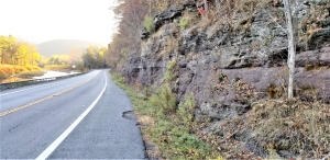
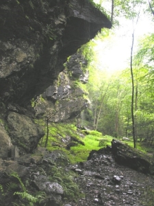
We recently visited the Cave House Museum of Mining and Geology, and we would like to continue writing about it today. The Museum is part of a 50-acre complex of industrial and educational facilities located well east of Howe Caverns. When you visit, we know that you will want to descend into the old Lester Howe cave. Back in his day you could take quite the tour but now you can only visit what was the beginning of Lester’s cave. You need to go to Howe Caverns itself for the long tour. Still, even If this is just a short tour, there are good things to see. Almost as soon as we entered the cave our guide shined his flashlight upon the thinly laminated limestone strata that make up the cave walls. There we immediately saw something that was very familiar to us. The cave is composed of a unit of rock called the Manlius Limestone, something that we see all across eastern New York State. It’s thinly bedded, fine grained strata took us back about 420 million years to a time when most of New York State was submerged by the shallow waters of something called the Helderberg Sea.
This was a very warm sea; North America lay just a little south of the equator. The Cobleskill area was enjoying a very tropical climate at that time. The thin laminations of the Manlius tell us a lot about what the whole region was like back in what geologists call the early Devonian time period. The thin strata here are the products of what are called algal mats. Once these thin strata were composed of sediments laying upon a mud flat and sheets of primitive algae grew across their surfaces. You might have to travel as far as the Persian Gulf so see something like this today.
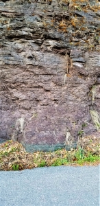
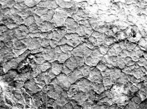
But there was much more to see here. Our guide shined his light on the cave ceiling and we immediately recognized one of those little wonders of geology; something called mud cracks. Mud cracks are polygonal imprints that formed at approximately the time of deposition. They speak to us of single moment in time all those million years ago. Mud cracks are also called desiccation cracks, which is to say that they formed at a time when the sediment was baking in the sun. Seas come and go; this was a time when the water had drained way. But there was more.
We looked up and gazed at that surface. To see such a rock is to literally see the past. Now we became time travelers, and in our mind’s eyes, we went back those millions of years and saw that mud flat. We had arrived at noon on a clear day in early August. The Sun’s heat seemed to pound down on the surface. There was not even the slightest of a breeze and the hot air pooled on the ground. In the distance, we could see rising currents of air distorted by the heat. This is the stuff of mirages and near the horizon there was the illusion of an expanse of water.
But there was no water. In fact, recent months had witnessed a terrible drought. The ground was bare marine sediment and it positively blistered in the sun. Over time, all moisture had been baked out of the ground. The sediment then slowly shrank and, as it did so, it began to contract into those polygonal masses bordered by polygonal cracks: classic mud cracks. We looked around again; an endless flat expanse spread out all around us. It was a dead landscape. We felt very small and alone in this vast, inhospitable Devonian land.
Then we turned our eyes away from the cave ceiling and suddenly, all around us, was the coolness of a dimly lit cave. This is the Cave House of modern times, but certainly not as it has always been.
Contact the authors at randjtitus@prodigy.net. Join their facebook page “The Catskill Geologist.” Read their blogs at “thecatskillgeologist.com.”