Geology at Windham Pt One
The Ice Age at Windham – Part one, an introduction
The Catskill Geologists; The Mountain Eagle; Sep. 8, 2017
Robert and Johanna Titus
We understand that we have a number of new readers in the town of Windham and we are glad about that. Let’s begin today a series of articles about the ice age history of that town. We can start at the relatively new Windham Path, located in the Batavia Kill Valley about a half mile east of town. It was opened about four years ago and offers some pleasant and easy walking.
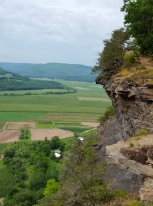
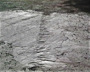
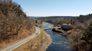
Take a look at our photo. Most people see an inviting place for recreation; naturally we see geological history. Our photo was taken from the path’s parking lot. If you go there we would like you to look straight ahead into the distance. Notice the broad flat surface on the distant right of our photo. Now take a look to the left. Our picture shows a low tree-covered hillock spread out east of those flats.
Most people just see landscape; let’s learn what the two of us see. That hillock on the left is what geologists call a moraine. That’s a heap of earth that was brought to where you find it by an advancing glacier. We look at it and, in our mind’s eyes, we see a glacier advancing from the right. It is advancing because the climate had been getting colder – cold is good for glaciers, right? But by the time our glacier reached the left side of this view, climate change had begun; it started warming up and the glacier began melting away – retreating to the left.
During its advance, that glacier had been bulldozing large amounts of earth, all of it piled up at the front of the ice. But, when the glacier was melting away, all that earth came to be left behind. That’s a moraine; this heap of earth speaks to the two of us of an important chapter in the ice age history of Windham.
What happened next? The retreating glacier was backing down the Batavia Kill Valley. It acted as a dam and that formed a glacial lake, lying between the retreating ice and the moraine. It’s the sediments of that lake that make up that flat lying surface in the distant right.
You might go there and do what we do. We always keep a barbeque skewer in the back of the car. We bring it down to flat surfaces like this one, and try to drive it into the ground. If, as we expect, we have found a lake deposit then the skewer will easily slide into the ground. If it doesn’t, it has hit a rock and it is not a lake deposit. Lake sediments are all silt and clay and don’t have rocks in them.
Well, we have seen the Windham Path as most people don’t. We gaze at it and we see an ice age landscape; we form visions of what it was like here at the close of the Ice Age. It can be an exhilarating experience.
But it is important to take this information and use it to form a broader picture of ice age history in the Batavia Kill Valley. Let’s get back in our car and head west on Rte. 23. We notice, right away, that we are crossing an elevated landscape with rolling and sinuous hillocks. This landscape continues until just past Mitchell Hollow road at the eastern end of the Windham business district. We have found another moraine and this one is a bigger one. Like the one at the Windham Path it speaks to us of a glacier advancing east through the Batavia Kill of long ago.
We have learned a lot about Windham, but we have a lot more ahead of us.
Contact the authors at randjtitus@prodigy.net. Join their facebook page “The Catskill Geologist” and read their blog at thecatskillgeologist.com.