
Draining Lake Woodstock
On the Rocks; The Woodstock Times
Jan. 9, 2009
Updated by Robert and Johanna Titus
We closed last week’s column with a remarkable image. We took you, the readers, west on Tinker Street and then we looked up into the air and saw 280 feet of ice water above us. This was the water of Glacial Lake Woodstock, probably the most important ice age feature in the Woodstock vicinity. We found ourselves at the bottom of this lake with all that ice water above us. That is an astonishing claim.
We left ourselves with the responsibility of proving this notion and today is the day. We would like to not only prove our assertion, but also give you a good example of how we geologists see the landscape as we travel about. We have a habit of seeing things and noticing things that other people don’t.
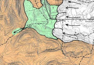
Mind you, we usually have to do a lot of exploring before we see these things. Let’s start out west of Bearsville which is also west of Lake Woodstock. On the map there is an interesting pass which hugs the north side of Acorn Hill. You can get there by driving up County Rte. 45, AKA the Wittenberg Road. At the top of the hill is a very inconspicuous bridge.
Bridges are supposed to cross rivers or at least creeks and there is a problem here. There is no water beneath the bridge. This is certainly a bit of a curiosity. But the problems get worse quickly. There is a bit of a valley here, a dry one. You can recognize where stream erosion has cut into bedrock and cut a small canyon. Canyon might be overstating it but there definitely used to be a good flow of water here. All this needs explanation!
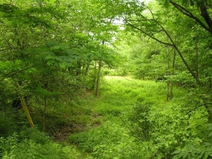
We are at the far western end of Glacial Lake Woodstock. Our canyon is dry today, but back at the end of the Ice Age there was a powerful flow here. Lake Woodstock was dammed to the east by a great wall of ice, the Hudson Valley Glacier. It was a time when the climate was warming, and the glacier was melting. The waters of Lake Woodstock had to go somewhere, and it was through this canyon that they flowed. Back then these flows entered into the drainage of today’s Little Beaver Kill.
There must have been a very powerful flow of water. Imagine, all of the glaciers in the region ere melting and much of that meltwater was flowing down Little Beaver Kill. It could not have been all that “little” back then!
When we visited the site, we looked and, in our mind’s eye, we saw the ice age torrent. Today, there is no water at all; we climbed down and walked a few yards along the floor of the old stream. We felt the raging whitewater flow passing beneath us. Back then it would have been certain death to jump into this current. But, as geologists, we are lucky; we can experience the best of both worlds and both times.
Now the point of all this is that this dry canyon lies at 880 feet above sea level. The floor of the Saw Kill Valley is at just about 600 feet. The difference, 280 feet is the depth of the old lake. It was a very deep lake.
The great physicists and mathematicians of the world are often still in their 20’s. Geology is different; it is an experiential science. Its best practitioners are not young hot shots, just out of graduate school. They are, like us, the seasoned veterans who have put in decades of work and are able to recognize features in the landscapes around them. You spend a lifetime absorbing your science and then you see it all around. Believe us, we see the world differently than most.
If you get a chance, please travel up Rte. 45 and see the inconspicuous little bridge. Your mind’s eye is just as good as ours. This is your chance to go back and see the Ice Age.
Contact the authors at randjtitus@prodigy.net. Join their facebook page “The Catskill Geologist.”


