An outcrop in winter – 9-7-23
A hillslope in winter
The Catskill Geologists
Robert and Johanna Titus
The Mountain Eagle
Feb 23, 2018
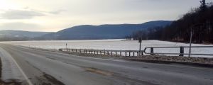
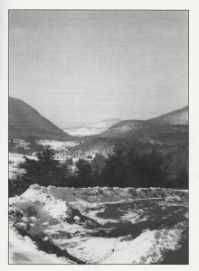
Being geology columnists we are on duty 24/7. Whatever we are doing, wherever we are going, we are on the alert. That is especially the case in winter, when conditions for doing geology are hardly at their peak. Well, a short time ago we were driving west on Rte. I-88. We had passed Cobleskill and were at about mile 88, when we spotted something we just had not noticed before. Take a look at our photo.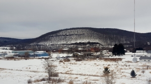
We were in the Schoharie Creek Valley and a fine hill rose above us to our right (north). During the summer there is nothing particularly special about this view, the hillslope is green with its forest. But, in winter it is all different. Two massive ledges leap into view, one at the hill’s bottom, the other high above. Now, we are pros, we know our way around the stratigraphy hereabouts, so we can describe these rocks without even climbing up there. Those two ledges are sandstones and those sands, about 390 million years ago, were deposited on the bottom of an ocean sometimes called the Catskill Sea. The rest of the slope is composed of endless horizons (strata) of dark shale. Shale is composed of sedimentary grains even smaller than sand; it is composed of hardened silt and clay. All this makes up a thin slice of time, something called the Devonian time period.
We pulled over and got out to take some photos and appreciated that, where we were standing, was once the bottom of the Catskill Sea. We became time travelers, all around us was salt water, and below us was a dark seafloor. It wasn’t a very deep ocean; we looked up and could just barely make out a very dim sunlight that came all the way down to us at the bottom. We looked around and saw, here and there, a handful of shellfish; the fauna of this sea bottom was pretty sparse. More than anything else, we sensed the absolute stillness of this marine setting; there were no currents and no sounds whatsoever. Geologists call this a stagnant seafloor, there was only very limited amounts of oxygen in the water, hence the scarcity of animals.
Then things changed. We felt a gentle current, coming from the east; it slowly picked up and we sensed sand grains being carried along, again from the east. What had happened? We had detected an influx of faster currents, carrying coarser grains of sediment; we were witnessing the very beginnings of the deposition of one of those sandstone ledges.
The question a geologist asks is – what is going on? What exactly caused a shale producing seafloor to become one that accumulates sand? And why were those currents and sands coming from the east? Those are very typical geological questions. Like any other scientists, when trying to solve such problems, Geologists focus on developing tentative solutions, called hypotheses. The two of us looked up at that hill again and quickly came up with several hypotheses.
We knew that, off to the east in Devonian times, there had been a rising chain of mountains; geologists call them the Acadians; they lay where the northern Appalachians are today. But, how was it that currents, carrying sand, had emanated from the shores of that mountainous terrain? That’s where our hypothesizing came in. Our first guess was that those mountains had entered into a phase of accelerating uplift. The rising mountains became steeper and that generated faster flowing mountain streams. Those streams became increasingly erosive and swept up vast amounts of sand. The currents reached out to where Cobleskill is today and deposited a thick horizon of sand, the first of our two ledges.
The second hypothesis was that the climate had changed; it had grown increasingly rainy. The heavy rains produced powerful mountain streams that flowed rapidly and powerfully down the slopes and washed massive amounts of sand into the Catskill Sea. That alternative hypothesis would have served equally well to make the sandstone ledges that we were looking at. Which hypothesis was the winner? Is either one correct?
We don’t know. Sometimes science is difficult.
Contact the authors at randjtitus@prodigy.net. Join their facebook page “The Catskill Geologist.” Read their blogs at “thecatskillgeologist.com.”
 W.M. Davis
 k at them. We found that the Roxbury 7 1/2 minute quadrangle map displayed the Gap. We found that the hump has a name; it is Jump Hill. Then we went back to our photo. The “hump” is actually something that lies in between two valleys. The contour lines on our map indicated a steep but steady slope for each of the two valleys. Each one of those is what geologists call a U-shaped valley. Every trained geologist on the planet Earth quickly recognizes the ice age history of such a valley. They record the passage of glaciers. As ice squeezed through a valley it ground away and eroded the bedrock. The shape that offers the least resistance is the U. Not surprisingly, over a period of time, glaciers will carve those U’s into the bedrock landscape. It gives each of them a path of least resistance. That forms a remarkably picturesque image and that helps make glaciated landscapes so attractive. We geologist are most fond of these U-shaped valleys.