Our reader’s rocks – Ice in Grand Gorge Gap?
The Catskill Geologists
Robert and Johanna Titus
Sept.15, 2017
We always give our email address at the bottom of each of our articles. And we can always be approached on our facebook page, so we hear from a lot of our readers. Often, they have questions, and we are usually able to help them with answers. Every once in a while, we thought we would answer one of these queries in the form of a column so here goes the first.
Recently we heard from a Gerry Hubbard. He sent us a photo of Grand Gorge Gap and wanted to know what the rounded hump on the right is. Take a look at our photo and you can see that hump. We had been wondering the same thing for years and so Gerry’s request got us to do something about the problem.
The first step is to get our topographic maps out and loo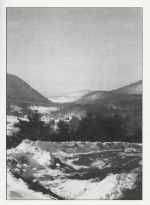 k at them. We found that the Roxbury 7 1/2 minute quadrangle map displayed the Gap. We found that the hump has a name; it is Jump Hill. Then we went back to our photo. The “hump” is actually something that lies in between two valleys. The contour lines on our map indicated a steep but steady slope for each of the two valleys. Each one of those is what geologists call a U-shaped valley. Every trained geologist on the planet Earth quickly recognizes the ice age history of such a valley. They record the passage of glaciers. As ice squeezed through a valley it ground away and eroded the bedrock. The shape that offers the least resistance is the U. Not surprisingly, over a period of time, glaciers will carve those U’s into the bedrock landscape. It gives each of them a path of least resistance. That forms a remarkably picturesque image and that helps make glaciated landscapes so attractive. We geologist are most fond of these U-shaped valleys.
Well, we studied the map and our photo and started speculating about what had happened here, way back, near the end of the Ice Age. Speculation is a word that scientists like to avoid; it sounds so – well speculative. So we use the word hypothesize instead. It sounds better. We hypothesized the following story: We hypothesize that the larger U-shape, on the left, is the older of the two. We think that a sizable glacier entered Grand Gorge Gap and began eroding the large U-shaped valley. Somewhere along the line, the ice was diverted and a second stream of it passed through what is the smaller, and we think younger, U-shaped on the right. All this erosion left Jump Hill in between.
We hope that Gerry likes our hypothesis. It conjures up quite an image. We travel north on Rte. 30 to where we can park and see this view. In our mind’s eyes we can imagine the advance of these glaciers; we can watch them carve the shapes of Grand Gorge Gap. That view gives us a whole new perspective on this site.
We hope you enjoyed our hypothesis. Perhaps you have a location that we could write about. Let us know.
Contact the authors at randjtitus@prodigy.net. Visit their facebook page at “The Catskill Geologist.” Read their blogs at “thecatskillgeologist.com