A great glacial Lake
The Catskill Geologists
Mountain Eagle; Jan. 19, 2018
Robert and Johanna Titus
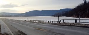
They say that you can’t make something out of nothing. “They,” of course, may well be wrong; it seems “they” usually are. We began to think such thoughts while traveling on Rte. 145 where, heading east, we were descending the hill on our way to Middleburgh. It was January, and that made the landscape covered with snow. And all that snow made the landscape before us all the more stunning. Take a look at our photo.

There, to the right of the highway, in all its snowy whiteness, was a great field of nothing. True, there were the remains of last summer’s corn, but the rest was broad, and flat, and white; it was indeed nothing. But not to us; we saw something; we were ready to do the impossible: to make something out of nothing.
We have written about this before; when a geologist sees a big flat nothing in the Catskills, then that geologist starts to think of a glacial lake. This one has a name; it is Glacial Lake Schoharie. The bottom of that lake was stretched out before us and it was big. When we got home, we got our maps out and found that the lake was about a mile across at Middleburgh. It stretched off to the north for miles and it did the same to the south.
But how deep was this lake? To answer that simple but important question we have to do a little elementary geology. We know that the Schoharie Creek Valley glacier dammed the valley to the north so just how did water get out of this basin? To find the answer to this, you have to continue to drive east on Rte. 145. You take a long hillslope up from Middleburgh until you reach an elevation of 1,200 feet. That’s a drive of about two miles. At the top of the hill, relatively steep slopes descend to the road. Soon you pass what is called Vlaie Pond. This location is the site of the Franklinton drain. Water from Glacial Lake Schoharie drained through this gap. It continued on down Catskill Creek as a very powerful flow.
The elevation at lake bottom, at the bottom of the hill, was at about 600 feet so that makes the old lake about 600 feet deep; that’s a lot of water.
If you make this trip we would like you to pull over and get out at the very top of the hill. Try to imagine the flow of water that passed through here late in the Ice Age. Look back to the west and see the lake spread out before you. It can be quite an experience to do this.
We have, in fact, written several articles about this lake in the Schoharie Creek Valley, but what impressed us this time is the impact of the view you get from the bottom of the hill. Look at our photo again. It nearly overwhelms you. We think it is one of those great experiences given to a geologist. It’s the sort of thing that we run this column in order to do.
Contact the authors at randjtitus@prodigy.net. Join their facebook page “The Catskill Geologist.”


