"I will never kick a rock"

A maze of streams, Oct. 20, 2022

in Uncategorized by

Into the Maze

On the Rocks – The Woodstock Times

Updated by Robert and Johanna Titus


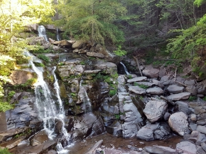
Look at a good, detailed map of the Hudson Valley in the vicinity just east of West Saugerties and Manorville. If you focus on the streams long enough, you just might notice something odd. A series of rivers descends the Catskill Front. Plattekill Creek is the most prominent, but there are several others, mostly unnamed. They all start out fine, descending picturesque mountain canyons as typical mountain streams. Then something peculiar happens. They all enter into a confusing complex maze of streams. Almost all the rivers and their tributary systems display a prominent north-south orientation. Within that pattern there are a large number of abrupt left and right turns as well. That gives our drainage a lattice-like appearance. We have searched the geological lexicon and we are not exactly sure what this should be called, but we think “rectangular drainage” is the best choice. It’s a curious pattern and, of course, there’s a reason for all this.


It all has a lot more to do with the bedrock than the rivers. You see, throughout much of this area there are alternating layers of sandstone and shale. All these stratified rocks are inclined; they dip into the earth toward the west. What that means is that the crust was once actually moved, tilting to produce north-south ridges of very solid rock.

The bedrock geology has been like this for probably hundreds of millions of years, but in recent times there have been changes. A mere 15,000 years ago, the Hudson Valley glacier flowed south through the valley. The ice must have been several thousand feet thick, and it acted like a great sheet of sandpaper. The passing glacier eroded the bedrock. Naturally the ice has had little trouble scooping out the shales, they are so soft. But the ice had much more trouble with the sandstones. Tough as that stuff is, the glacier was still able to pluck loose large blocks of it and carry them off. The ice actually adheres to the rock and yanks it loose. That has sharpened and straightened the many ridges of sandstone.

All this leads us back to those rectangular river patterns. You see rivers have a very hard time getting through the ridges of sandstone, so they have followed the shales. They have eroded out their channels along the bands of the softer rock. Still, a Hudson Valley creek eventually has to east toward the Hudson River. So, from time to time, the creeks have found breaks in the sandstones and have worked their way through those ridges. That’s the origin of the sharp rectangular turns.

Plattekill Creek is typical. It is a gorgeous mountain stream as it drops out of the Catskills and passes through the village of West Saugerties. Everything continues well until it reaches the vicinity of Blue Mountain and the Saugerties Reservoir. There it abruptly makes a sharp south turn and follows a beeline in that direction for three miles. Here it is nestled between ridges of sandstone.

It’s in this vicinity that Plattekill Creek has entered that maze of tributaries. And it’s here where that north-south lineation of the drainage is best developed. We have worked the area and we believe that there are about 11 ridges of sandstone here. All of them offer barriers that can confine the tributaries into those north-south straightjackets. You can see some of these ridges and several more. Head east on Rte. 212 until you get to Shultis corner and the intersection with the Glasco Pike. From here, you can head east and count the ridges of rock that cross the pike. Or you can continue on Rte. 212 and count the ridges on your way toward Centerville. If you do count the ridges, don’t expect the numbers to come out the same. We get different numbers every time we take the route. Geology isn’t Physics and we don’t worry too much about exact numbers.

Plattekill Creek eventually has to cut through to the Hudson and it begins the hard part of its journey near where it is crossed by Rte. 212. Between here and its junction with the Glasco Turnpike, the Plattekill has to cut its way through the tough rocks of the Mount Marion ridge. In some stretches of this flow, the Plattekill has been forced to carve real canyons. You can take the Fish Creek Road north from High Woods and cross the Plattekill in this vicinity.

In the end, there is nothing all that special or mysterious about this maze of rivers. It’s just another among many landscape features, but a geologist does take a quiet satisfaction from noticing and understanding.

Contact the authors at randjtitus@prodigy.net. Join their facebook page “The Catskill Geologist.”

The Greenport Mastodon 10-6-22

in Uncategorized by

The Greenport Mastodon

Windows Through time; The Register Star; July 8, 2010

Updated by Robert and Johanna Titus


Our topic today is one of the most notable paleontological discoveries ever made here in our region: the discovery of the first mastodon. This was a big find and was made a long time ago: way back in 1705. That’s when a Dutch colonist found a huge tooth in a bank of clay along eastern bank of the Hudson in Greenport. It weighed almost five pounds, and our Dutchman must have been most impressed. Not so impressed, however, that he was not willing to sell it for a half gill of rum to a local assemblyman.

The tooth worked its way up the political food chain to Lord Cornbury, then Governor of the New York Colony. He sent it off to the Royal Society of London. Today, that would be like sending it to the Smithsonian Institute. The tooth attracted a lot of attention in London, and from just the right people.  n 1705 not much was known about prehistoric monsters, in fact very little was known about prehistory. The scientists of the time were puzzled.

There were two hypotheses. Some thought that the tooth belonged to a remarkable beast or fish, but they could not imagine what type of creature it had been.  Lord Cornbury and others had another idea; the tooth belonged to a “giant” and they were talking of a biblical giant, referred to in Genesis 6:4. This tooth had belonged to a huge human being!

To his credit Cornbury sent people to search the original site for more skeletal remains and they found parts of a very decomposed skeleton. It was estimated that the beast had been 70 feet long. In fact, they had greatly overestimated the beast, but you can imagine how they reacted to the very notion!

From the very beginning there were others who speculated that the remains belonged to an elephant, but what kind of an elephant and how did such an animal get to the Hudson Valley? For the second part of the question, here again, contemporary religious views offered a solution: the beast had been carried here by Noah’s Flood. That would be difficult to prove, but it was an appealing idea.

It would take decades to solve the other half of the problem – what kind of elephant had it been – and that came when many more mastodon bones were found in the Ohio River Valley and a complete skeleton was unearthed in New York’s Orange County. Now, at last, scientists could see a whole skeleton with tusks and, clearly, they were those of an elephant, or at least a distant cousin of today’s elephant. But only a distant cousin; now there was a new scientific problem.

The mastodon did not match the Indian or the African elephants; it was a separate and new species. But nobody had ever seen such a creature in the wild. That was still another problem. At this time the very notion of extinction was a new and very troubling concept. Could the mastodon have once lived and then gone extinct? Not many people were comfortable with that thought. Theologians, especially, argued that no such thing could have happened; God would not allow extinction of species he had created. Perhaps not, but if so, where were the living mastodons?

That was a serious scientific question in the early 1800’s and President Thomas Jefferson, a pretty accomplished amateur scientist in his own right, thought he could solve it. The Lewis and Clark expedition was soon to head west, and Jefferson specifically asked its members to be on the lookout for mastodons. Certainly, the animals were extinct here in the east, but perhaps they still lived somewhere out there beyond the Appalachians.

Well, Lewis and Clark found a lot of things all across America, but they never saw and elephant. The results were clear: mastodons were extinct and, like it or not, extinction was something that really could happen – and really had happened.

All this adds up to some very important early progress in the science of paleontology. Our Greenport mastodon was among the very first prehistoric monsters to be discovered. Later generations would find the dinosaurs, but these great mastodons are still quite something to contemplate. All this would lead, with time, to a great understanding of the exotic nature of our planet’s paleontological history; it was one of the first glimpses into life’s distant past.

But equally important was the introduction of the very concept of extinction. We take that for granted today but it was a most remarkable, and disturbing, discovery two centuries ago.

Contact the authors at randjtitus@prodigy.net. Join their facebook page “The Catskill Geologist.”


Edison and Burroughs at Boyhood Rock. Sept. 29, 2022

in Uncategorized by

THE CATSKILL GEOLOGISTS BY PROFESSORS ROBERT AND JOHANNA TITUS

Burroughs And Edison – At Woodchuck Lodge

One of the true treasures of the Catskills is the heritage of famed nature writer John Burroughs. We have long admired his writings, dating from the 1860’s to the 1920’s, and we are proud to have a complete set of his books in our library. Have you read any of Burroughs works? You really should; there are some very good anthologies available at local bookstores and at Amazon. One of them, “In the Catskills,” focuses on Burroughs Catskill essays. We have been invited to run a geology walk at Woodchuck Lodge, Burroughs’ summer home in Roxberry, that’s at 1:00 on Saturday, Oct 1st. We expect that Woodchuck Lodge will be open for tours on that day. But, not surprisingly, our focus will be on the geological history of the site. We plan to do an easy hike around the property and look at the evidence for its distant past. Burroughs favorite science was ornithology. He had a lifelong fascination with birds. But we always like to say that his second favorite science was geology and that is borne out by the many geological discussions he includes in his books. Another lifelong fascination? We think so.


Burroughs was well aware of the ice age history at Woodchuck Lodge, and we have spent time documenting some of it. His favorite single spot there was famed Boyhood Rock. See our first photo. He spent many an hour sitting upon it, no doubt contemplating the nature all around. So have we. We will visit that rock on our walk. It’s a very large boulder composed of local Devonian sandstone. That gives it an interesting Devonian history, but it is also a glacial erratic, brought there by a glacier descending south, down the valley. We will stand by Boyhood Rock and gaze into the past and envision the passage of the ice. Boyhood Rock is Burroughs gravesite, and we hope he will be listening. But there is something else. See our second photo. That’s John on the right. And that is Thomas Edison on the left. The photo is from an old book about Burroughs’ life and the caption claims that Burroughs was showing glacial striations to Edison – at Woodchuck Lodge. We are going to see if we can find that exact spot on our walk. If we can, then perhaps we can see what the two of them saw, some very good ice age history! We will be sharing a moment in time with two very great men.

Burroughs was likely the most famous and important person ever born and raised in our Catskills. Our walk will be a good introduction to the man – and his second favorite science.

Contact the authors at randjtitus@prodigy.net. Join their facebook page “The Catskill Geologist.” Read their blogs at “thecatskillgeologist.com.”

An autumnal view 9-22-22

in Uncategorized by


Fall Vistas – Atop the Hudson River

The Register Star – Windows Through Time, Sept. 2010

Updated b Robert and Johanna Titus


Autumn is the season to get out and see the outdoors before it is too late. Winter will be here all too soon and we ought to enjoy ourselves and our landscapes now, while we still can. We are fortunate to live in such a scenic region. There is so much to see. We have, in recent years, added a very fine vista to our Hudson Valley. That is the Cross Hudson Pedestrian Bridge which links the west bank of the river with Poughkeepsie. Officially it is the Walkway over the Hudson State Park, but whatever you would like to call it, it is a marvel.

The bridge was originally built in 1889 as a steel cantilever railroad bridge and it served that way for decades. It was considered an engineering marvel in its day and for a long time it was the only cross Hudson bridge south of Albany.  Use of the bridge declined after 1960 and it closed for railroad traffic in 1974 and lay unused for a quarter of a century. Then in the late 90’s plans were developed to turn it into a pedestrian and bicycle bridge and all that came to fruition in 2003. Since then, it has been open to the public for recreational enjoyment. You can walk from one side to the other and soak in the views of the Hudson Valley to the north and to the south. It’s well worth the effort.

But this is alleged to be a geology column and we are not supposed to be singing songs about bridges, are we? How do we justify all this? Easy. we just had to go and look around. We went down to the west end of the bridge and hiked out onto it a few weeks ago. We brought a camera and resolved to find something we could write about. It didn’t take long. About halfway across we began to take note of a series of relatively small hills on the east side of the river. One was due east of the bridge, right in the heart of Poughkeepsie. Then there were four more arrayed as if in a line, extending off to the north.

It would have been easy to have not noticed them at all; none of them are all that big. But we quickly guessed that we were looking at a kind of hill that is common farther north in the Hudson Valley. These appeared to be remnants of the Ice Age – hills called drumlins. We have written about drumlins several times before. They are beautiful little hills sculpted by the ice of passing glaciers. They are perfectly symmetrical with steep slopes dipping east and west. The north slopes are also steep, but the south slopes have much more gentle inclines. Drumlins are shaped just like upside down spoon bowls, and they are common, – very, very common throughout much of the Hudson Valley.

When we came home, we dug out our topographic maps and confirmed that these were drumlins. We even found that Dutchess Community College is built upon one of them. One of their academic buildings is even called Drumlin Hall.

It all got more interesting when we continued to study the maps. It seems that these are just about the most southern of all the Hudson Valley drumlins. To the south they just disappear; to the north they become very frequent. Everywhere we looked, these drumlins lay atop all other landscape features. They had to be younger than all other features. That clinched it; we were looking at the record of the one last final advance of the ice. We had been looking at the last gasp of the Ice Age!

Now, in our mind’s eye, we returned to the Cross Hudson Bridge and gazed east. we watched as that glacier moved south. It wasn’t very large and just barely rose above the horizon. Compared with earlier chapters of glaciation, this one was puny. It was near the end of the Ice Age and this small glacier was all that could be managed. But all around us, the Hudson Valley was bleak and baron. This was still very much an ice age landscape.

We watched the glacier advance to the center of what would someday be Poughkeepsie and then it slowed down and ground to a complete halt. This last chapter was running out of steam (or running out of cold?). We continued to watch and then the ice began to melt. It melted away and vacated this part of the Hudson Valley. As the glacier disappeared the drumlins emerged from the ice and took on the appearance that they still display. Contact the authors at randjtitus@prodigy.net. Join their facebook page “The Catskill Geologist.” Read their blogs at “thecatskillgeologist.com.”


Foothills of the Catskills Sept.8, 2022

in Uncategorized by

The Hoogebergs

Updated by Robert and Johanna Titus

On the Rocks – The Woodstock Times


We often use lots of words without having a precise notion of what they mean. English is designed for that as sometimes its words need to have just a touch of (appropriate) vagueness. For example, just what does the word “mountain” mean? There are many good answers to that and each one is different from all of the others, and each one may still be correct. Similarly, what exactly does the word “hill” mean? It gets worse. What does “foothill” mean? Hills don’t have feet, so let’s pursue the issue and do it with a good local example.

The Catskills are often called mountains although many debate that heatedly. Our Catskill Mountains have foothills and some of those are very close to Woodstock. The foothills that we are speaking of are the hills of the Hoogeberg Range. If you have never heard the term that’s quite excusable, the Hoogebergs are not great or famous peaks.

The Hoogebergs are a series of small hills lying parallel to the Catskill Front, the great eastern escarpment of the Catskills. They are found just a few miles east of the Catskills and rise to only 600 or 700 feet in elevation. That’s merely a third of the elevation of the Catskills themselves. Thus, they are adjacent and parallel to Catskills, but just not very elevated. They are like a practice run before the big mountains, hence the term foothills. You can see the Hoogeberg Range if you drive north on the Kings Highway (Rt. 31), south of Saugerties and Rt. 32, north of Saugerties. The ridge looms to your left (west). It forms a fairly impressive horizon.


            Hoogebergs – lower right

You can easily go and see the rock that makes up the Hoogeberg Range. There are several locations where there are gaps in these hills, and they let you drive right through the bedrock. Rt. 212 cuts through at the village of Veteran, Rt. 32 cuts through at Quarryville and the Glasco Pike cuts through at the village of Mt. Marion. In each of these locations there are fine exposures of the bedrock right along the road.

What is the Hoogeberg and why is it here? Visit the Rt. 212 exposures and you will observe some very fine, thick, rugged sandstones. These are tough rocks and they have resisted the efforts of weathering and erosion. To the east and west, softer rocks have eroded away, and as they did the Hoogeberg came to be sculpted into a series of hills. These sandstones belong to a geological unit called the Mt. Marion Formation. It is mostly sandstone, and it makes up the Hoogeberg Range. Park along Rt. 212 here and poke around for a bit and look the sandstones over. You may find the fossils of some marine shellfish. That tells us a lot. The Mt. Marion sands accumulated at the bottom of an ocean, sometimes called the Hamilton Sea. The sands once made up the floor of that sea.

At the Glasco Pike exposure you will learn more about the Mt. Marion and the Hoogeberg. This outcropping is at the bridge which crosses Plattekill Creek. The lower levels of the exposure are mostly black shale. Up above, however, those sandstones make their appearance. We talked about this in an earlier column. This sequence of strata records a transition from an offshore, deep water setting to a nearshore, shallow ecology. The offshore accumulated muds that hardened into the shales while coastal sands would eventually harden into the Mt. Marion sandstones.

If you look carefully, you may notice that the strata at these locations are not perfectly horizontal; they dip gently to the west. These rocks were all here during the late Devonian time period and they were involved in crustal tilting that was part of a mountain building process, then going on in New England. The tilting of these resistant strata raised those sandstones and exposed them to erosion. They responded by eroding into the hills we see today. The tilting accounts for much of the form of the Hoogeberg. Its west-facing side is generally a gentle slope, reflecting the original tilting, while the east-facing front was eroded into a steep slope, often a cliff.

Crustal tilting, shallowing seas, ancient shellfish, there’s a lot of history in these pretty little foothills and they do make up a significant feature in our local landscape, even if they are just foothills.

Contact the authors at randjtitus@prodigy.net. Join their facebook page “The Catskill Geologist.” Read their blogs at “thecatskillgeologist.com.”

A winding stream 9-1-22

in Uncategorized by

A winding river

On the Rocks; The Woodstock Times

Robert and Johanna Titus


Congressman Faso has introduced a resolution in Congress that recognizes the natural resources and economic importance of the Upper Delaware River watershed. It was supported by something called the Coalition for the Delaware River Watershed. As       much as anything, the resolution is looking to improve the area’s tourist trade and we are in full support of that. This picturesque region is well worth visiting. Have you spent much time there? Well maybe we can give you a good reason to visit.

We have often enjoyed driving west on the valley of the East Branch of the Delaware. It passes through a largely rural region which presents us with a very scenic drive. What you are bound to notice very quickly is how the slopes on each side of the river are so steep. The valley is narrow here and its slopes rise up and tower over the river itself.

That’s unusual in the Catskills region. Our river valleys typically slope down far more gently. The story becomes more interesting when you get a good map out. Take a look at our first picture.

It traces the river from Corbett to Linden. Notice the broad sinuous curves that the river follows. These sorts of curves are commonplace among rivers but, not with this sort of river. These river bends have quite a story to tell.

This is properly called a meandering stream and the derivation of the word meandering is obvious; it refers to our sinuous curves. The problem is that meandering streams are supposed to be found on rivers that flow across enormous wide floodplains but there are virtually no floodplains here. The Mississippi is very good at meandering. And the other problem is that meandering streams are not supposed to be found at the bottoms of canyons. We geologists have a lot of explaining to do.

The story goes back to the 1930’s when a New York State Museum geologist named Rudolf Ruedemann began looking at these rivers and did some deductive thinking. Ruedemann knew that meandering streams had to have formed on broad floodplains and so he, in his mind’s eye, traveled back in time and saw our western Catskills as they may have been during the Cretaceous Time Period, about 100 million years ago. Ruedemann deduced that the western Catskills region must have been flat at that time. No hills or mountains rose up as they do today. That flat landscape, he reasoned, was ideal for the production of meandering streams. And so it was that rivers which would become our modern East and West Branches of the Delaware, found themselves flowing in those broad sinuous meanders. And they were flowing across an enormous flat landscape.

Then things changed. The crust of our whole region began a long slow uplift. The East and West Branches found themselves in a rising landscape. Their meanders had no choice but to begin eroding into that rising land. The meanders were trapped as, above them, were those rising slopes. That is how our distinctive landscape came into being.

All this speaks of the East Branch occupying a very old river channel. It could be that the banks of the river date back to the Cretaceous, 100 million years ago – or more. If you get a chance to go out there, and can climb down to the edge of the river, then think about all this. During the Cretaceous the river was right where it is today. There were dinosaurs in abundance during the Cretaceous. Stand on the edge of the river and look to your left and then to your right. There once were dinosaurs there, drinking the waters of this stream!

Contact the authors at randjtitus@prodigy.net. Join their facebook page “The Catskill Geologist.” Read their blogs at “thecatskillgeologist.com.”

The Widow Jane Mine; 8-25-22

in Uncategorized by

The Widow Jane Mine

Windows Through Time; The Register Star 201

Robert and Johanna Titus

We have been spending a lot of time in Rosendale lately. (Early spring, 2016) There is a lot of good geology there and some pretty good tourist attractions as well. Things will soon be opening up for the season at the Century House Museum and the Widow Jane Mine. These are parts of the Snyder Estate Natural Cement Historic District. They are operated by the Rosendale Historical Society. They all commemorate the natural cement industry that flourished here during the nineteenth and early twentieth centuries. Last year we did an article in Kaatskill Life magazine about all this and recently we also did a column on the production of lime. So maybe you would like to go and visit Rosendale and see what happened down there. Now is the time.

Natural cement is made from a form of rock called dolostone. It is a close cousin of limestone, but differs in that it has a lot more magnesium in its crystal structure. Natural cement was made from a unit of rock called the Rondout Formation. That is found abundantly in Rosendale. During the peak of the cement industry, the Rondout was extensively quarried. Its stone was crushed and then cooked in large industrial kilns. The resulting lime was just of the right composition to make a very high quality form of cement. It was real durable material. It held up better than other forms of cement. Just as important, nobody had to mix sand or any other additives with it; it came with just the right recipe of silt and clay already in it. So not only was it good stuff but it must have been relatively inexpensive as well.

Not surprisingly, a sizable industry grew in Rosendale by the turn of the 20th Century. There had been a great rush of building in the Northeast and quality materials were sorely needed.  As you wander around the town you can still see a lot of remnants from those mining days. There are relic kilns and a number of old mine openings. The Widow Jane Mine was a typical operation. Miners cut into the bedrock and excavated what are called “pillar and room mines.” They cut into the dolomite but left sizable pillars to support the mine as it expanded. These can be visited and explored and it is fun to do so. The mines can be seen at two stratigraphic levels. The lower Rondout was called the Whiteport Dolostone and the upper part of the unit was the Rosendale Dolostone. Each was just the right composition, so each was excavated extensively. In between the two dolostones was a pure limestone of no economic value. It’s the Glasco Limestone and, if you can get close enough to it, you will find a large number of fossils, many of them corals. We enjoyed seeing them. The Glasco is an outdoors museum.

Post and pillar mining

We would like you to get used to watching for pillar and room mining. That is because you are likely to encounter it from time to time as you wander around Ulster County. This sort of mining was once very widespread and all the old caverns are still around. Sometimes you can even get into some of them.

The value of the Rondout Formation was first appreciated in the middle 1820s. By the 1840s extensive quarrying was underway. The American economy was fast growing and there was a real need for cement. Rosendale satisfied much of that need. Rosendale cement came to be used for some historical sites. It was ideally well suited for large foundations. It was used in the construction if the Statue of Liberty, parts of the Capital Building and the Brooklyn Bridge.

There were problems with natural cement and eventually history was not kind to this industry. It took a very long time for natural cement to fully harden and that made it unpopular. If you made a highway of it, it took a month to cure and be useable. Portland cement was discovered, or invented if you prefer. It’s an artificial sort of cement that is made of commonplace limestone but requires the addition of sand and other ingredients. By the early 20th century Portland cement was gradually replacing the natural form. The last Rosendale plant survived into the 1920s

The Century House website says that things will be open daily for self-guided tours from 10:00 to 4:00. The Museum will be open Sundays, 1:00 to 3:00, from Mother’s Day through September. You will want to keep up with their events listings. They do hold occasional concerts in the old mine. We are most curious to find out what the acoustics are like.

Contact the authors at randjtitus@prodigy.net. Join their facebook page “The Catskill Geologist.” Everybody else has.

The Present is a Key to the Past along the Catskill Creek

in Uncategorized by

The Present is a key to the past

On the Rocks; The Woodstock Times, 2018

Robert and Johanna Titus


We are always happy to see the opening of a new land preserve anywhere in the Hudson Valley or the Catskills. We get out to see them as soon as we can, always hoping that there is some good geology. After all, we always need things to write about. Recently, Scenic Hudson opened a new preserve near where we live. It is called the Mawignack Preserve and it is off Snake Road in Jefferson Heights, just west of Catskill. Mawignack, we understand, means where two rivers come together. Kaaterskill and Catskill Creek are joined nearby.

We have always enjoyed the many landscapes found along Catskill Creek. Our home lies just (safely) above the Creek. So, we were most eager to see Mawignack. But when we found an aerial photo online, we were a bit disappointed. The preserve seemed to be little more than a very large field with a trail circling it. The trail did pass right along a thousand feet or so of the creek and that boded well, but–it just didn’t seem like all that much; this was not the Grand Canyon. But we went and looked for ourselves. It turned our pessimism was not justified. There as some very interesting geology there.

Google Earth will quickly help you find your way to Snake Road in Jefferson Heights. The Preserve parking lot is near the end of the road. You follow orange trail markers a short distance until there is a split in the trail. Take the right branch. That’s where we found that things got interesting.

We saw something that we imagine few others would notice. Take a look at our first photo, look carefully. Do you see what sort of resembles a stream channel – it trends right to left in the far distance and then left to lower right in the middle of the photo. It looks like something that geologists call a stream meander. It’s dry so it is not an active river, but it was, long ago, late in the Ice Age. How do we know that?

We use something that is fundamental to geology. It’s called uniformitarianism. Briefly that means that when we find a problem in the geological past, something that we can’t figure out right away, then we search the modern world for something similar that we can use to find the solution. We like to say that “the present is a key to the past.” Let’s do that right now. We would like to take you to the “present” at a location you are likely to be familiar with. That’s the Thorn Preserve at its intersection of Zena and John Joy Roads. The southeast corner of the Preserve overlooks a bend in the river, the Saw Kill, exactly the same as we suggest used to be at the Mawignack preserve

Well, what happened at Mawignack? Why is that bend in the river high and dry? We think we know that too. First things first though; the Mawignack Preserve, back then, was indeed a river meander. It lay atop the old floodplain of an ice age version of Catskill Creek. But today’s Catskill Creek flows about ten feet lower that the old floodplain. How could that be? Yep, we think we know that too.

You see, at the end of the Ice Age, when a lot of glacial ice was melting, the ground was rising. As the ice melted away, weight was removed, and the ground simply expanded and rose—about ten feet. Catskill Creek eroded down into those ten feet, to establish its modern channel while abandoning its old floodplain. That floodplain, with its old meander, is still there, perched those ten feet above the river. But the meander can only be seen by the trained eyes of modern geologists.

So, we propose that the two preserves be considered as twins, twin landscapes separated by time. Visit the Thorn Preserve and see a modern floodplain with a modern meandering stream and then go to Mawignack and see an old floodplain with an old meander. Mawignack looked just like Thorn, perhaps 10,000 years ago. Thorn may well look like Mawignack—10.000 years from now.

Contact the authors at randjtitus@prodigy.net. Join their facebook page “The Catskill Geologist.


Herbert Hoover at Prattsville – Aug 11, 2022

in Uncategorized by


Herbert Hoover–at Prattsville?

On the Rocks; The Woodstock Times 2019

Updated by Robert and Johanna Titus


Herbert Hoover doesn’t get much good press these days. He is largely remembered for not being able to end the Great Depression. Not enough people remember that, earlier in his life, he was able to feed and save the lives of millions of people in Belgium during World War I. He did the same in the Soviet Union soon after that war. He, it has been argued by some, saved more human beings from death than any other person in history. Hoover was a conflict of terms–a brilliant bureaucrat. We are fond of him, and his wife Lou too, for another reason. They were both trained in geology–at Stanford University (for Lou, an extraordinary accomplishment for a 19th Century woman). Herbert called himself a mining engineer, but he was, first of all, a geologist.

Can we do a little bragging? Geologists typically are given to have very good spatial relationship skills. We need them in our everyday functioning with the structures of rocks. We see through time too; we have to when we are dealing with millions of years of earth history. We geologists develop very structured ways of thinking and the two of us think we see that in Herbert Hoover’s biography.

For us, the best and most geological part of the story takes us back to the horrible flooding on the Mississippi in the year 1927. There had been extremely heavy rainfall over the winter of 1926-1927. By April the waters of the Mississippi were rising over the river’s levees at scores of locations. Hundreds of thousands of people were flooded out of their homes (largely poor and black). The highway and railroad infrastructures were being destroyed. It can be called the worst flood in the Mississippi’s history; it was a rampage.

There had, hitherto, been no real history of federal assistance for such emergencies, but federal help was needed. The governors of six southern states called for Herbert Hoover’s help. The engineer, Herbert Hoover was, after all, the world’s foremost disaster relief specialist. Somewhat reluctantly, President Calvin Coolidge appointed him chairman of a special cabinet committee. The committee had its first meeting – two hours later – and Hoover was in Memphis early the next morning.

Hoover assembled an enormous fleet of boats and airplanes to work the flooded river. He put together an army of military and volunteer civilian personnel to carry out what needed to be done. He built 154 refugee camps to house those displaced by the flood. He provided those refugees with health care, particularly the immunizations they would need. What Hoover did not have was federal money. But working with the Red Cross, Hoover directed a very successful fundraising effort. His emergency relief was, more than anything else, a volunteer effort. And it was a resounding success.

When we read the story of Hoover and the Mississippi, we thought back to our experiences at Prattsville, just two weeks after the Hurricane Irene flooding. We wanted to cover the story as both journalists and geologists but when we got to the Rte. 23 bridge at the eastern edge of town, we found the National Guard there. We were not welcome to enter Prattsville that day, especially as “journalists.” Well, we won’t tell you how, but we snuck in. But then, unfortunately, we still had to walk about a mile to get to where the cleanup action was going on. The Federal Emergency Management Administration (FEMA) was there in force and had been for most of those two weeks. It didn’t take long before we saw evidence that an experienced team who knew what they were doing, had been hard at work. Each house we passed had been marked with a red X to indicate there were no people, especially dead people, inside. We passed a field filled with derelict cars. All had been towed there to get them out of the way. Another field was piled high with the flotsam and jetsam of flooding. Again, nothing was going to get in the way of FEMA activities.

When we got to the center of town, we found it buzzing with activity The National Guard was there too, in large numbers. And busloads of volunteers were arriving every few minutes, or so it seemed. People who had been hard at it for a while were covered with mud. We found a food service area with a sign that said they would feed anyone, any time, day or night–free.

We were most impressed.
Well, you probably see where we are going with all this. The ghost of Herbert Hoover was there in Prattsville. He had been something of a Teddy Roosevelt type of progressive Republican. Give the government a problem and watch and see if it can’t solve it. FEMA came long after Hoover (1978), but we think we saw his approach to the Mississippi floods at Prattsville. We speculate that Hoover’s 1927 efforts were, at the least, inspirational to today’s FEMA.

Contact the authors at randjtitus@prodigy.net. Join their facebook page “The Catskill geologist.”

When Cow Slip Rock Slipped Aug. 4, 2022

in Uncategorized by

THE CATSKILL GEOLOGISTS BY ROBERT AND JOHANNA TITUS

When Cow Slip Rock Slipped.

Most of our field studies consist of pretty serious science, but sometimes we just like to go out and have some fun. We love to chase down geologies that we find on old postcards. Recently we found a good one. Take a look at our first photo; it’s a post card mailed in 1934. It shows something called “Cow Slip Rock” on Basic Creek at the south end of Hempstead Lane in Greene County’s Freehold. On the postcard, Cow Slip Rock was the big, tilted boulder lying upon four slightly smaller ones. We like big rocks so of went to look for it. We thought there might a good story there and we were right.


Take a look at our second photo. There it is, Cow Slip Rock at least 87 years later, and things have changed. It is still in the same location and still tilted as it was long ago. But those other boulders are gone. What happened; where did they go? The answer is fairly obvious; there had to have been a terrible storm in the not too distant past. It generated a streamflow that was powerful enough to sweep away those smaller boulders but not strong enough to move the heavier Cow Slip Rock itself. We stood at this site and let our mind’s eyes take over. We soon were able to experience that flood. There was a very heavy rainfall. We knew that the flow of water had risen considerably. It must have overflowed the stream banks, including where we stood, in a full-fledged flood. The two of us were soon up to our necks in the cold flow. We felt raging, foaming, pounding torrents all around us. White caps speeded by. We heard the loud roaring noise of this flood, and that roar was punctuated by the cracking sounds of fast-moving boulders smacking into each other. We looked across the stream and saw Cow Slip Rock quickly dropping down. All those other boulders were being swept away.

It was an incredible moment; perhaps something that only geologists can hope to experience. We had been privileged to witness an important instant in the history of Basic Creek. should have feared for our lives, but we were the mind’s eyes, and nothing can harm the human imagination.

But when did this actually happen? We don’t know; it’s an event lost to time. But our best guess is that this was hurricane Irene in the August of 2011.

Contact the authors at randjtitus@prodigy.net. Join their facebook page “The Catskill Geologist.” Read their blogs at “thecatskillgeologist.com.”

1 9 10 11 12 13 43
Go to Top