"I will never kick a rock"

Monthly archive

August 2022

The Widow Jane Mine; 8-25-22

in Uncategorized by

The Widow Jane Mine

Windows Through Time; The Register Star 201

Robert and Johanna Titus

We have been spending a lot of time in Rosendale lately. (Early spring, 2016) There is a lot of good geology there and some pretty good tourist attractions as well. Things will soon be opening up for the season at the Century House Museum and the Widow Jane Mine. These are parts of the Snyder Estate Natural Cement Historic District. They are operated by the Rosendale Historical Society. They all commemorate the natural cement industry that flourished here during the nineteenth and early twentieth centuries. Last year we did an article in Kaatskill Life magazine about all this and recently we also did a column on the production of lime. So maybe you would like to go and visit Rosendale and see what happened down there. Now is the time.

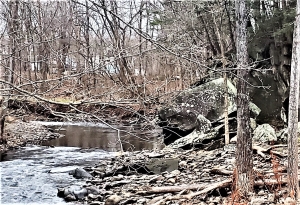
Natural cement is made from a form of rock called dolostone. It is a close cousin of limestone, but differs in that it has a lot more magnesium in its crystal structure. Natural cement was made from a unit of rock called the Rondout Formation. That is found abundantly in Rosendale. During the peak of the cement industry, the Rondout was extensively quarried. Its stone was crushed and then cooked in large industrial kilns. The resulting lime was just of the right composition to make a very high quality form of cement. It was real durable material. It held up better than other forms of cement. Just as important, nobody had to mix sand or any other additives with it; it came with just the right recipe of silt and clay already in it. So not only was it good stuff but it must have been relatively inexpensive as well.

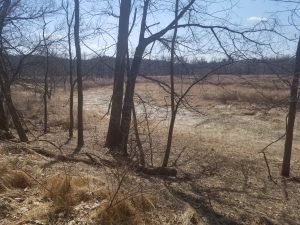
Not surprisingly, a sizable industry grew in Rosendale by the turn of the 20th Century. There had been a great rush of building in the Northeast and quality materials were sorely needed.  As you wander around the town you can still see a lot of remnants from those mining days. There are relic kilns and a number of old mine openings. The Widow Jane Mine was a typical operation. Miners cut into the bedrock and excavated what are called “pillar and room mines.” They cut into the dolomite but left sizable pillars to support the mine as it expanded. These can be visited and explored and it is fun to do so. The mines can be seen at two stratigraphic levels. The lower Rondout was called the Whiteport Dolostone and the upper part of the unit was the Rosendale Dolostone. Each was just the right composition, so each was excavated extensively. In between the two dolostones was a pure limestone of no economic value. It’s the Glasco Limestone and, if you can get close enough to it, you will find a large number of fossils, many of them corals. We enjoyed seeing them. The Glasco is an outdoors museum.

Post and pillar mining

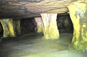
We would like you to get used to watching for pillar and room mining. That is because you are likely to encounter it from time to time as you wander around Ulster County. This sort of mining was once very widespread and all the old caverns are still around. Sometimes you can even get into some of them.

The value of the Rondout Formation was first appreciated in the middle 1820s. By the 1840s extensive quarrying was underway. The American economy was fast growing and there was a real need for cement. Rosendale satisfied much of that need. Rosendale cement came to be used for some historical sites. It was ideally well suited for large foundations. It was used in the construction if the Statue of Liberty, parts of the Capital Building and the Brooklyn Bridge.

There were problems with natural cement and eventually history was not kind to this industry. It took a very long time for natural cement to fully harden and that made it unpopular. If you made a highway of it, it took a month to cure and be useable. Portland cement was discovered, or invented if you prefer. It’s an artificial sort of cement that is made of commonplace limestone but requires the addition of sand and other ingredients. By the early 20th century Portland cement was gradually replacing the natural form. The last Rosendale plant survived into the 1920s

The Century House website says that things will be open daily for self-guided tours from 10:00 to 4:00. The Museum will be open Sundays, 1:00 to 3:00, from Mother’s Day through September. You will want to keep up with their events listings. They do hold occasional concerts in the old mine. We are most curious to find out what the acoustics are like.

Contact the authors at randjtitus@prodigy.net. Join their facebook page “The Catskill Geologist.” Everybody else has.

The Present is a Key to the Past along the Catskill Creek

in Uncategorized by

The Present is a key to the past

On the Rocks; The Woodstock Times, 2018

Robert and Johanna Titus


We are always happy to see the opening of a new land preserve anywhere in the Hudson Valley or the Catskills. We get out to see them as soon as we can, always hoping that there is some good geology. After all, we always need things to write about. Recently, Scenic Hudson opened a new preserve near where we live. It is called the Mawignack Preserve and it is off Snake Road in Jefferson Heights, just west of Catskill. Mawignack, we understand, means where two rivers come together. Kaaterskill and Catskill Creek are joined nearby.

We have always enjoyed the many landscapes found along Catskill Creek. Our home lies just (safely) above the Creek. So, we were most eager to see Mawignack. But when we found an aerial photo online, we were a bit disappointed. The preserve seemed to be little more than a very large field with a trail circling it. The trail did pass right along a thousand feet or so of the creek and that boded well, but–it just didn’t seem like all that much; this was not the Grand Canyon. But we went and looked for ourselves. It turned our pessimism was not justified. There as some very interesting geology there.

Google Earth will quickly help you find your way to Snake Road in Jefferson Heights. The Preserve parking lot is near the end of the road. You follow orange trail markers a short distance until there is a split in the trail. Take the right branch. That’s where we found that things got interesting.

We saw something that we imagine few others would notice. Take a look at our first photo, look carefully. Do you see what sort of resembles a stream channel – it trends right to left in the far distance and then left to lower right in the middle of the photo. It looks like something that geologists call a stream meander. It’s dry so it is not an active river, but it was, long ago, late in the Ice Age. How do we know that?

We use something that is fundamental to geology. It’s called uniformitarianism. Briefly that means that when we find a problem in the geological past, something that we can’t figure out right away, then we search the modern world for something similar that we can use to find the solution. We like to say that “the present is a key to the past.” Let’s do that right now. We would like to take you to the “present” at a location you are likely to be familiar with. That’s the Thorn Preserve at its intersection of Zena and John Joy Roads. The southeast corner of the Preserve overlooks a bend in the river, the Saw Kill, exactly the same as we suggest used to be at the Mawignack preserve

Well, what happened at Mawignack? Why is that bend in the river high and dry? We think we know that too. First things first though; the Mawignack Preserve, back then, was indeed a river meander. It lay atop the old floodplain of an ice age version of Catskill Creek. But today’s Catskill Creek flows about ten feet lower that the old floodplain. How could that be? Yep, we think we know that too.

You see, at the end of the Ice Age, when a lot of glacial ice was melting, the ground was rising. As the ice melted away, weight was removed, and the ground simply expanded and rose—about ten feet. Catskill Creek eroded down into those ten feet, to establish its modern channel while abandoning its old floodplain. That floodplain, with its old meander, is still there, perched those ten feet above the river. But the meander can only be seen by the trained eyes of modern geologists.

So, we propose that the two preserves be considered as twins, twin landscapes separated by time. Visit the Thorn Preserve and see a modern floodplain with a modern meandering stream and then go to Mawignack and see an old floodplain with an old meander. Mawignack looked just like Thorn, perhaps 10,000 years ago. Thorn may well look like Mawignack—10.000 years from now.

Contact the authors at randjtitus@prodigy.net. Join their facebook page “The Catskill Geologist.


Herbert Hoover at Prattsville – Aug 11, 2022

in Uncategorized by


Herbert Hoover–at Prattsville?

On the Rocks; The Woodstock Times 2019

Updated by Robert and Johanna Titus


Herbert Hoover doesn’t get much good press these days. He is largely remembered for not being able to end the Great Depression. Not enough people remember that, earlier in his life, he was able to feed and save the lives of millions of people in Belgium during World War I. He did the same in the Soviet Union soon after that war. He, it has been argued by some, saved more human beings from death than any other person in history. Hoover was a conflict of terms–a brilliant bureaucrat. We are fond of him, and his wife Lou too, for another reason. They were both trained in geology–at Stanford University (for Lou, an extraordinary accomplishment for a 19th Century woman). Herbert called himself a mining engineer, but he was, first of all, a geologist.

Can we do a little bragging? Geologists typically are given to have very good spatial relationship skills. We need them in our everyday functioning with the structures of rocks. We see through time too; we have to when we are dealing with millions of years of earth history. We geologists develop very structured ways of thinking and the two of us think we see that in Herbert Hoover’s biography.

For us, the best and most geological part of the story takes us back to the horrible flooding on the Mississippi in the year 1927. There had been extremely heavy rainfall over the winter of 1926-1927. By April the waters of the Mississippi were rising over the river’s levees at scores of locations. Hundreds of thousands of people were flooded out of their homes (largely poor and black). The highway and railroad infrastructures were being destroyed. It can be called the worst flood in the Mississippi’s history; it was a rampage.

There had, hitherto, been no real history of federal assistance for such emergencies, but federal help was needed. The governors of six southern states called for Herbert Hoover’s help. The engineer, Herbert Hoover was, after all, the world’s foremost disaster relief specialist. Somewhat reluctantly, President Calvin Coolidge appointed him chairman of a special cabinet committee. The committee had its first meeting – two hours later – and Hoover was in Memphis early the next morning.

Hoover assembled an enormous fleet of boats and airplanes to work the flooded river. He put together an army of military and volunteer civilian personnel to carry out what needed to be done. He built 154 refugee camps to house those displaced by the flood. He provided those refugees with health care, particularly the immunizations they would need. What Hoover did not have was federal money. But working with the Red Cross, Hoover directed a very successful fundraising effort. His emergency relief was, more than anything else, a volunteer effort. And it was a resounding success.

When we read the story of Hoover and the Mississippi, we thought back to our experiences at Prattsville, just two weeks after the Hurricane Irene flooding. We wanted to cover the story as both journalists and geologists but when we got to the Rte. 23 bridge at the eastern edge of town, we found the National Guard there. We were not welcome to enter Prattsville that day, especially as “journalists.” Well, we won’t tell you how, but we snuck in. But then, unfortunately, we still had to walk about a mile to get to where the cleanup action was going on. The Federal Emergency Management Administration (FEMA) was there in force and had been for most of those two weeks. It didn’t take long before we saw evidence that an experienced team who knew what they were doing, had been hard at work. Each house we passed had been marked with a red X to indicate there were no people, especially dead people, inside. We passed a field filled with derelict cars. All had been towed there to get them out of the way. Another field was piled high with the flotsam and jetsam of flooding. Again, nothing was going to get in the way of FEMA activities.

When we got to the center of town, we found it buzzing with activity The National Guard was there too, in large numbers. And busloads of volunteers were arriving every few minutes, or so it seemed. People who had been hard at it for a while were covered with mud. We found a food service area with a sign that said they would feed anyone, any time, day or night–free.

We were most impressed.
Well, you probably see where we are going with all this. The ghost of Herbert Hoover was there in Prattsville. He had been something of a Teddy Roosevelt type of progressive Republican. Give the government a problem and watch and see if it can’t solve it. FEMA came long after Hoover (1978), but we think we saw his approach to the Mississippi floods at Prattsville. We speculate that Hoover’s 1927 efforts were, at the least, inspirational to today’s FEMA.

Contact the authors at randjtitus@prodigy.net. Join their facebook page “The Catskill geologist.”

When Cow Slip Rock Slipped Aug. 4, 2022

in Uncategorized by

THE CATSKILL GEOLOGISTS BY ROBERT AND JOHANNA TITUS

When Cow Slip Rock Slipped.

Most of our field studies consist of pretty serious science, but sometimes we just like to go out and have some fun. We love to chase down geologies that we find on old postcards. Recently we found a good one. Take a look at our first photo; it’s a post card mailed in 1934. It shows something called “Cow Slip Rock” on Basic Creek at the south end of Hempstead Lane in Greene County’s Freehold. On the postcard, Cow Slip Rock was the big, tilted boulder lying upon four slightly smaller ones. We like big rocks so of went to look for it. We thought there might a good story there and we were right.


Take a look at our second photo. There it is, Cow Slip Rock at least 87 years later, and things have changed. It is still in the same location and still tilted as it was long ago. But those other boulders are gone. What happened; where did they go? The answer is fairly obvious; there had to have been a terrible storm in the not too distant past. It generated a streamflow that was powerful enough to sweep away those smaller boulders but not strong enough to move the heavier Cow Slip Rock itself. We stood at this site and let our mind’s eyes take over. We soon were able to experience that flood. There was a very heavy rainfall. We knew that the flow of water had risen considerably. It must have overflowed the stream banks, including where we stood, in a full-fledged flood. The two of us were soon up to our necks in the cold flow. We felt raging, foaming, pounding torrents all around us. White caps speeded by. We heard the loud roaring noise of this flood, and that roar was punctuated by the cracking sounds of fast-moving boulders smacking into each other. We looked across the stream and saw Cow Slip Rock quickly dropping down. All those other boulders were being swept away.

It was an incredible moment; perhaps something that only geologists can hope to experience. We had been privileged to witness an important instant in the history of Basic Creek. should have feared for our lives, but we were the mind’s eyes, and nothing can harm the human imagination.

But when did this actually happen? We don’t know; it’s an event lost to time. But our best guess is that this was hurricane Irene in the August of 2011.

Contact the authors at randjtitus@prodigy.net. Join their facebook page “The Catskill Geologist.” Read their blogs at “thecatskillgeologist.com.”

Go to Top