The Roe Jan, Part Two: The drowned lands – May 5, 2022
Stories in stone
Updated by Robert and Johanna Titus
Last week we began a journey down the Roeliff Jansen Kill to learn about its geology and its ice age history. We traced the stream back to its origins above Bash Bish Falls and followed it to the village of Copake. We witnessed the melting of glaciers and the tremendous flow of meltwater that once rushed out of the Berkshires and into Columbia County. To see this is a privilege that comes with learning an area’s geology.
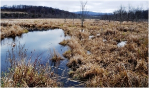
But this time we are going to see a very different sort of Roeliff Jansen Kill. If you look at a map of its drainage basin from Copake to about four miles off to the west, you will find something that we can call the “drowned lands.” At the heart of this region is a parcel of land owned by the Columbia County Land Conservancy. It is officially called the “Drowned Lands Swamp Conservation Area.” This is only part of the total drowned lands which covers much of Copake and most of northeastern Ancram.
The Roeliff Jansen Kill flows through the region. Here the stream’s landscape is entirely different from anything we will see downstream or have seen upstream. The drowned lands are characterized by ponds and small lakes. The largest of these is Copake Lake which you can see, northwest of Copake on Route 7. We counted at least a dozen others; most of them are off the highway and out of sight.
The ponds and lakes are not the most important features in this stretch of the Roeliff Jansen Kill. Far more important are the numerous, and often very large, wetlands. Wander the roads of this area and you will commonly observe swamps, marshes, and bogs, big and small. All this we are, herein, referring to as the drowned lands.

There is a hierarchy of terms that we use to describe types of wetlands. Swamps are just dry enough to support trees and shrubs without drowning them. Marshes are so wet that trees and shrubs are excluded. Bogs are still wetter, and, over time, they accumulate peat deposits. I expect that all three will be found in this region.
But how did the drowned lands come to be? What was their origin? To answer that we have to go back, once again, to the end of the Ice Age. We have seen that vast quantities of meltwater were pouring down through Bash Bish Gorge and flowing out across the lands of Copake. Off to the west, starting in western Ancram, were a series of small hills. These impeded the westward flow of all this water and much of it would be pooled in the area of today’s drowned lands. We like to use the word “puddling” to describe this. Our wetlands are remnants of this ice age history, but there is more.
Along many of the banks of the streams that flow through this area are exposures of fine-grained sand deposits. We would like to spend more time studying these, but we are guessing that they are generally lake sediments and date back to post ice age times.
As you drive this area, try to imagine a few more feet of water covering all of the swampy locations. Go to the Drowned Lands Preserve and see it as a fairly large lake. If you want to, you can add a mastodon or two along the shores!
It would take a lot of very strenuous field work to properly document all of this. A geologist needs to hike about with a soil auger. He will stop here and there and drill holes into the ground to see the extent of the lake deposits. Over time, if he keeps at it, he can construct a map of the old lakes and ponds as they were. We wish we could do this, but we do not have the time.
Still, we are fairly confident of what we are hypothesizing here. We travel the region of the drowned lands, and we look into an ice age past. Then we see a landscape still struggling to overcome the effects of that history. We see Roe Jan drainage which has, even today, not yet developed enough efficiencies to get rid of all the meltwater that has accumulated.
Contact the authors at randjtitus@prodigy.net. Join their facebook page “The Catskill Geologist.”


