
Geology at the New Baltimore Conservancy, Part two: a very deep sea.
Windows Through Time, Dec 12, 2013
Robert and Johanna Titus
We have been exploring the geological history of a property maintained by the New Baltimore Land Conservancy. It is the old Armstrong farm site, just a little south of the Village of New Baltimore along County Rte. 61. We have worked with several similar groups in the past. We developed a geology trail for the Woodstock Land Conservancy at their Sloan Gorge property in Woodstock. We have consulted with the Columbia Conservancy, across the Hudson, and have written a number of articles about their various properties.
We admire the members of these groups, most of them volunteers, and we appreciate their efforts to preserve scenic landscapes and save them for generations to come. But commonly, they do not know much about the geological past of their sites. That is where we come in. We explore these properties and study the geologic evidence. Then we research what is known about them, what professional geologists have learned, and finally we pass on what we have discovered to the people of these groups. Often, we summarize what we have learned in our columns.
Today, we continue our trek down the old farm path at the Armstrong site. Last time, we had lost ourselves into a distant ice age past. This week we will descend far deeper into the past, and far deeper in every other way. Soon we found what was left of an old shallow quarry. There was a hodgepodge of broken boulders and masses of rock. All of it was almost black in color. We quickly recognized that there were two types of rock in the old quarry. One was a type of sandstone called greywacke. That is a very dark sandstone; it is dark because it contains large amounts of silt and clay lying in between the sand grains. We geologists sometimes call this a dirty sandstone and that is good descriptive term for the rock. The other rock type was black shale, a thinly laminated, very fine-grained petrified mud.
We recognized the rock unit; it is one of the most commonly seen geological formations in this part of the Hudson Valley. It is called the Austin Glen Formation. This mass of rock is quite old, in fact probably about 465 million years old. But such great antiquity is just routine for geologists; that’s not what impressed us. It was the environment of deposition that was so fascinating.
We already knew a good bit about the Austin Glen Formation. We knew that its sediments had accumulated at the bottom of a pretty deep ocean. This oceanic basin has a technical name; it is called a foreland basin. What you need to make a foreland basin is a nearby rising mountain range; it helps a lot if it is a long linear mountain range. The mountains we are talking about were an ancient version of today’s Taconic Mountains.
Well, this foreland basin was a long linear, very deep-water basin that ran adjacent to those mountains. As the mountains were rising, the basin was subsiding. Rising mountains are always weathering and eroding and that produces a lot of sediment. It is this sediment that was the genesis of the Austin Glen Formation. The sediment was carried by steep powerful streams from the mountains into the sinking foreland basin.
We suddenly encountered a very vivid image of the floor of that sea. In that small quarry we found a special type of lithology. Take a look at our photo. It shows a slab of graywacke with some very striking patterns on its surface. These structures are called flute casts. Flute casts are produced by the rapid flow of a sediment rich current across the floor of an ocean. We were looking at a petrified submarine landslide.
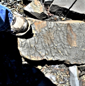
In our mind’s eyes we could imagine a single moment of time long ago. An ancient earthquake had just shaken the old seafloor and threw masses of sediment up into suspension. It slowly began to flow downslope towards the bottom of the basin. It picked up speed and momentum. Those speeds could have reached 30, 40, or 50 miles per hour. This was a powerful, even violent moment on the seafloor. But it was just a moment.
Eventually that landslide got to the bottom of the basin, and it began to slow down. Sediment began to settle onto that seafloor. But first it pressed into the soft sticky muds that had already been down there. As it did, it sculpted those flute cast structures. Our journey into the past was over and we were in that little quarry again. We knew so much more about those rocks and about the Conservancy itself.
Contact the authors at randjtitus@prodigy.net. Join their facebook page “The Catskill Geologist.”


