"I will never kick a rock"

Monthly archive

December 2019

Name that Tomb 12-27-2019

in Uncategorized by

WHAT’S REALLY BURIED IN THE COLONEL’S TOMB?
On the Rocks
The Woodstock Times, Oct. 24,1996
Updated by Robert and Johanna Titus

Prattsville, along the banks of the Schoharie River, is steeped in Catskills history. It’s emblematic of the most progressive aspects of the area’s story, and at the same time, it represents many of the mistakes people made as our region developed. Zadock Pratt was the towering, overwhelming personality in the town’s development. Even today his influences permeate the village.
Pratt was a founder of the Catskill tanning industry. From 1833 to 1846 his Prattsville tanneries turned out shoe leather for the New York City market. His tanneries, however, were dependent upon the bark of the hemlock tree, and when they were all cut down, the industry closed. We frown upon the wanton destruction of the Catskill hemlocks that characterized the 19th century, but our collective wisdom is based upon a history of trial and error. It was men such as Pratt who provided the errors.
But Pratt is also remembered for progressive attitudes toward urban planning. His Prattsville was a pioneering model in that field. Pratt laid out the streets, built the Greek Revival homes and planted the 1,000 trees that lined the village streets. Pratt founded churches and the town’s academy as well. Prattsville today is still truly Pratt’s town.
Zadock Pratt was a great man, but we suspect that history would have mostly forgotten him except for the one singular act of vanity that he was responsible for. Pratt, the Rameses II of the Schoharie, is remembered for Pratt Rock, his would-be tomb.


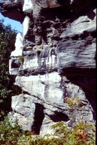
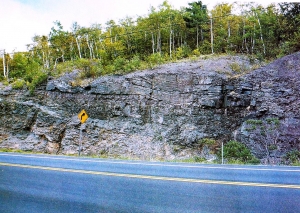
Pratt Rock consists of a series of stone carvings on a glacially plucked cliff along Rte. 23, just east of town and overlooking the old Pratt farm. The site is now a town park and open to visitors. You can hike the winding path up the steep slope toward the main carvings. If you tire along the way you can sit upon stone seats thoughtfully carved into the mountain. The main level of carvings displays images and symbols of his life. There are carvings of the hemlock tree, a horse which hauled the bark to the tanneries, a strong arm to do the work and other emblems of the great man’s life. There is a bust of Pratt himself and a poignant carving of his only son who died in the Civil War. Then there is the Pratt burial chamber itself.
Unlike the pharaohs, Pratt was never buried in the grotto carved out for him. One story is that the chamber was unsuitable for burial as it leaked water when it rained. The chamber is still there, and when we looked it over, we found that there may be some truth to that tale, along with a good geological story about Pratt Rock.
Pratt Rock is carved into sedimentary strata from the old Catskill delta. Deposited nearly 400 million years ago, the sediments here record the coastal regions of a delta similar to that of the Mississippi River today. This was once the coastline of the old Catskill Sea. Rivers flowed across this location and poured their waters into the old ocean.
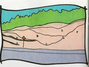
There is a lot of history here. We had little trouble finding bits and pieces of the old Gilboa forest, and we could picture its foliage along the old stream banks. But the most interesting horizons we found were those at the burial chamber itself. The ceiling of the chamber is made up of inclined strata. This horizon of rock formed on the floor of an old stream channel. The beds slope down to the right, which was once one side of a river, and farther along the outcrop they rise up again on the other shore. When we looked at the chamber ceiling, we found a horizon rich in a hash of broken plant remains. This stratum is likely very porous and it’s quite possible that this accounts for the leakage that caused the burial project to be abandoned. The pharaohs of arid Egypt faced no such problem.
And so, this is one of the many ironies of geology. The great Zadock Pratt is buried in a nearby graveyard with all the other common folk of old Prattsville. That may be because about 375 million years ago some small river made a wrong turn. It’s not Pratt buried in Pratt’s tomb, but the sands of an ancient river!

Contact the authors at randjtitus@prodigy.net. Join their facebook page “The Catskill Geologist.”

A River of Rock 12-19-19

in Uncategorized by

A River of Rock
The Greenville Press
Updated by Robert and Johanna Titus

One of the most scenic descents out of the Catskills is along Rte. 23, downhill from East Windham. To your left is the vast expanse of the upper Hudson Valley stretching, it would seem, forever. We enjoy a good view as much as anybody, but when we travel along this road, today’s scenery has to compete with an ancient one. There are a many excellent, large exposures of bedrock along the way. They are all of an eye-catching red and thus are typical Catskill lithologies.
Brick red is the emblematic rock color of the Catskills bedrock. It is the color of the red soils and sediments that accumulated on the great Catskill delta complex of the Devonian time period. In your imagination, take yourself back almost 400 million years to the Devonian time. All around you are the low swampy bayous of a great delta. It’s an ancient version of Louisiana. To the east a great mountain range rises above the horizon. This is an ancient version of the Himalaya. There is a lot of imagery in these old Catskill Delta deposits and this stretch of Rte. 23 may be one of the best locations to learn how to interpret them. And, of course, we don’t just mean learning to make cold scientific judgments about the rock, but to really travel through time to this place as it once was.

Heading up the road from the south, watch for the Cornwallville Road. Just past it is a parking area with a fine panoramic view to the northeast. The view certainly deserves some attention, but we are here to see the rocks. Across the road and between 0.1 and 0.2 miles farther uphill is a fine and very typical outcropping of the Catskill Delta. As you approach it, watch for two striking channel-form structures (A&B on picture). These are actually the cross sections of two Devonian rivers, stacked one upon the other. The upper channel is composed of massive beds of sandstone, the very sands that filled the old channel. This channel eroded its way into an even older channel (A); the lower one is composed of thinner-bedded sandstones. At the bottom of this river of rock can be seen a deposit of gravel (C), it was carried here by strong currents and left at the bottom of the channel. To the right is a steep bank margin (D), this was probably the erosive side of the river. Beyond that is a sequence of red sandy shales (F). These sediments accumulated upon the floodplain, probably during floods. Floodplain deposits, of our Devonian time, were turned red by oxidation. That’s common throughout the Catskills and the origin of that brick red color that I extolled earlier.
To the left of the channels you might notice some dark, sometimes rusty-looking horizons (E). These strata are thinly bedded, just laminations. Dark sediments, like these, were never oxidized, they were waterlogged instead. Floodplain organic matter was preserved and darkened the beds. This appears to be a floodplain swamp. Below it you can see a peculiar horizon. It has an olive color with many blotches of yellow and green. This has been interpreted as a fossil floodplain soil.

 
Think about what is here. This is an ancient river and floodplain. The channels, river banks, floodplain soils and swamps are just as real now as they were about 375 million years ago. Back then, however, this was a living environment, composed of soft sediments and inhabited by green plants and breathing animals. Today that’s all still here; it’s just been converted into a stone sculpture. What we see is just the surface exposure, a fragment of what is truly here. The rest must be imagined. Beyond our seeing and buried in the mountains, an ancient river of rock flows through a stone landscape. The river, a meandering ribbon or rock, reaches westward, today as it did in the Devonian, and flows into a buried ocean of rock.
All this is routine for geologists. We approach outcrops expecting to be transported to some ancient habitat. We grow accustomed to this, but we never forget what a miracle it really is.

Contact the authors at randjtitus@prodigy.net. Join their facebook page “The Catskill Geologist.”

A shallow sea at 5 Mile Point in Cooperstown 12-12-19

in Uncategorized by

A Shallow Sea
The Cooperstown Geologist
Updated by Robert and Johanna Titus

Geologists are deductive scientists. We go out and study outcroppings of sedimentary rock with the purpose of gathering evidence of how they came to be formed. The evidence is mostly descriptive; we look at the rocks and see things in them that speak to us of ancient environments. Each small observation leads to a deduction and a series of observations and deductions leads us to broad conclusions. Let’s go out and see how this works.
An especially fine outcrop can be found in Mohican Canyon just west of Lake Otsego’s Five Mile Point. Five Mile Point is a mass of sediment that projects out into the lake. You guessed it; it’s five miles north of Cooperstown. Take Route 80 north until you get there and then turn left onto the road that ascends the hill. On each side of the road you will encounter very fine exposures of rock. The rock is made up of layers; it is stratified. That leads us to our first deduction; layered rock forms at the bottom of the sea. We learned earlier about the Catskill Sea which once covered our region. We have gone back about 375 million years and found that sea once again.
The strata are a mixture of sandstones and shales. We can make more deductions. Shale forms as mud on the bottom of quiet, probably deeper, seafloor. Sandstone accumulates in more active, perhaps more shallow seas. When shale dominates, then we deduce deeper water; when sandstone predominates we can deduce shallower settings. When sandstone and shale are evenly mixed we are in between.
The thickness of the strata helps too. When the beds are thin we can deduce the likelihood of quieter, and probably deeper, conditions. When the beds are thick we can deduce rapid current activity which is associated with shallow seafloors.


The lower stretch of our outcrop is mostly of thin bedded shale. We can deduce that this sequence represents fairly deep water sea bottom. But as we ascend the road, things change. More and more sandstone starts to appear in the outcrop and more and more often the sandstone is thicker bedded. Some sandstone strata are a foot thick.
If you have a chance to take the trip, then start at the bottom and stroll slowly towards the top of the outcrop. See if you can agree with our observations. But what all does this mean?
We need to do a little stratigraphy. That’s the science of stratified rocks and it’s practiced a lot in the Leatherstocking Country. All of our rocks up here are stratified. The rocks at Mohican Canyon are classified as belonging to something called the Otsego Sandstone. That’s a unit of rock which is commonly seen at outcrops in our area. The lower stretch of the Otsego is called the “Otsego A” and the upper part is the “Otsego B.” That’s fairly informal but quite functional stratigraphy and it leads us to our most important deductions.
The sequence here speaks to us of a shallowing sea. During Otsego A times, the Catskill Sea was quiet and accumulated lots of mud. Still water runs deep and that’s the case with the Otsego A; it was a relatively deep body of water. Today, you would have to go quite a distance offshore to get to a modern Otsego A. But time never stops and as our region passed from the time of A to the time of B, the waters of the Catskill Sea were shallowing.
We geologists find shallowing sequences quite often. Our observations and deductions lead us to recognize times when seas were shrinking away. We call such events “regressions” and the one at Five Mile Point is a gem. We are looking at real history here; this actually happened. Once there was a deep beautiful saltwater Catskill Sea here in Otsego County. It spread across upstate New York for an enormous length of time and then it began to disappear. Where did is come from and where did it go? We have just begun our story; we need many more observations and many more deductions.

Contact the authors at randjtitus@prodigy.net. Join their facebook page “The Catskill Geologist.”

A Gelogical Tourist Trap Dec. 5, 2019

in Uncategorized by

Flocks of geologists
Windows Through Time, The Register Star
June 4, 2009
Updated by Robert and Johanna Titus

Dear Robert and Johanna – I have been enjoying your columns in the Hudson-Catskill newspapers. I have a question. I wonder what so many college groups have been studying at the Leeds exit along Rte. 23? – WJM – Athens

WJM: Thanks for the good question. Over the years we have heard this one from a lot of people. Anybody who frequently drives this stretch of the road in the autumn or the spring will have seen sometimes large groups of college students climbing over the rocks at this site. You will be interested to know that this is one of the great “geological tourist traps” of the American northeast. Any eastern geologist who is anybody in geology has been to this location. I wonder if we even know any geologist who has not been here. So, what is the big draw?
The answer is that this outcropping displays something called an “angular unconformity,” and this one is a very historic structure. Read on and learn about this peculiar feature. If you are going by it sometime soon, you might want to stop and see for yourself that which captivates so many young geologists. If you do, you will see some interesting geology.


The right (east) side of the outcrop displays what are called stratified sedimentary rocks. These are thick horizons of alternating gray sandstone and black shale. Each layer of rock was once deposited as sediment at the bottom of the sea. Back then, these were horizons of sand and mud. That’s a most surprising observation. Look around. Do you see and saltwater here? This does not look like the bottom of an ocean, but it once was. That’s incredible but true.
We see these rocks; we look into their distant past and see the ocean that was once here. It has been a very long time since the earliest geologists figured this out. So long that we have forgotten who first made this amazing deduction. The first person to write these thoughts down was Scottish geologist James Hutton in the 1790’s. This was not only one of the most important discoveries in the history of geology but of science itself. Look around and think about it. You are standing at what really was the bottom of a sea. These strata of sand and mud formed on that long-ago seafloor. Turn a full 360 degrees; hold up your hands and feel the saltwater that was once here. Times have changed!
But there is something else here and it is also important. Notice that the sandstone and shale strata are tilted, they are nearly vertical. When sediments are deposited on the floor of an ocean they are laid down in horizontal sheets. These strata should have stayed that way, but that is not the case here. Again, they are nearly vertical. They must have come to be tilted and that’s where the story gets even more interesting. Think about how heavy these rocks are and how much energy it would take to tilt them. The only processes that can lift and tilt such rocks are those of mountain building events.
These rocks are from something called the Ordovician time period; they are about 450 million years old. That’s when North American was enduring a great collision with an eastern landmass much the size of today’s Japan. You would call it Europe or – better – “proto-Europe.” Collisions, of this sort, initiate chapters of downwarping. The crust folds downward and the seas flood the region. Those seas accumulated the sand and mud that hardened into today’s rocks. Then continued collision came to reverse the whole process and caused a massive mountain building uplift. All this is how those rocks formed, and how they were tilted and raised to above sea level. But, of course, there is still more.
The rocks on the left (west) side of the outcrop are limestones. They formed during a time that is called the Devonian Period and they are only about 420 million years old. They formed in a shallow tropical sea and the rocks are sometimes rich in marine fossils. If you stop here, perhaps you can find a few. This was the bottom of a second ocean!
These too are stratified, but these strata dip to the left. Once again, North America was enduring a collision with another Japan-sized land mass. It was “déjà vu all over again!” Once again, the crust was folded downwards and that is when the limestone formed – in a shallow tropical sea. That downwarping would eventually be followed by another uplift. That’s when the second tilting occurred.
The boundary between these two units of rock is what we call an angular unconformity. The word angular refers to the angle between the strata of the two rock units. The word unconformity refers to the period of period of erosion that followed the first mountain building event and preceded the second.
And that is the centerpiece of what we, and all those college students, are looking at. This is a petrified record of two mountain building events. There is a lot of history here and young geologists come from all over to see it. You can too.

Contact the authors at randjtitus@prodigy.net. Join their facebook page “The Catskill Geologist.”

Go to Top