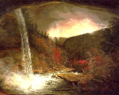
Flocks of geologists
Windows Through Time, The Register Star
June 4, 2009
Updated by Robert and Johanna Titus
Dear Robert and Johanna – I have been enjoying your columns in the Hudson-Catskill newspapers. I have a question. I wonder what so many college groups have been studying at the Leeds exit along Rte. 23? – WJM – Athens
WJM: Thanks for the good question. Over the years we have heard this one from a lot of people. Anybody who frequently drives this stretch of the road in the autumn or the spring will have seen sometimes large groups of college students climbing over the rocks at this site. You will be interested to know that this is one of the great “geological tourist traps” of the American northeast. Any eastern geologist who is anybody in geology has been to this location. I wonder if we even know any geologist who has not been here. So, what is the big draw?
The answer is that this outcropping displays something called an “angular unconformity,” and this one is a very historic structure. Read on and learn about this peculiar feature. If you are going by it sometime soon, you might want to stop and see for yourself that which captivates so many young geologists. If you do, you will see some interesting geology.
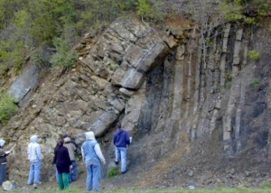
The right (east) side of the outcrop displays what are called stratified sedimentary rocks. These are thick horizons of alternating gray sandstone and black shale. Each layer of rock was once deposited as sediment at the bottom of the sea. Back then, these were horizons of sand and mud. That’s a most surprising observation. Look around. Do you see and saltwater here? This does not look like the bottom of an ocean, but it once was. That’s incredible but true.
We see these rocks; we look into their distant past and see the ocean that was once here. It has been a very long time since the earliest geologists figured this out. So long that we have forgotten who first made this amazing deduction. The first person to write these thoughts down was Scottish geologist James Hutton in the 1790’s. This was not only one of the most important discoveries in the history of geology but of science itself. Look around and think about it. You are standing at what really was the bottom of a sea. These strata of sand and mud formed on that long-ago seafloor. Turn a full 360 degrees; hold up your hands and feel the saltwater that was once here. Times have changed!
But there is something else here and it is also important. Notice that the sandstone and shale strata are tilted, they are nearly vertical. When sediments are deposited on the floor of an ocean they are laid down in horizontal sheets. These strata should have stayed that way, but that is not the case here. Again, they are nearly vertical. They must have come to be tilted and that’s where the story gets even more interesting. Think about how heavy these rocks are and how much energy it would take to tilt them. The only processes that can lift and tilt such rocks are those of mountain building events.
These rocks are from something called the Ordovician time period; they are about 450 million years old. That’s when North American was enduring a great collision with an eastern landmass much the size of today’s Japan. You would call it Europe or – better – “proto-Europe.” Collisions, of this sort, initiate chapters of downwarping. The crust folds downward and the seas flood the region. Those seas accumulated the sand and mud that hardened into today’s rocks. Then continued collision came to reverse the whole process and caused a massive mountain building uplift. All this is how those rocks formed, and how they were tilted and raised to above sea level. But, of course, there is still more.
The rocks on the left (west) side of the outcrop are limestones. They formed during a time that is called the Devonian Period and they are only about 420 million years old. They formed in a shallow tropical sea and the rocks are sometimes rich in marine fossils. If you stop here, perhaps you can find a few. This was the bottom of a second ocean!
These too are stratified, but these strata dip to the left. Once again, North America was enduring a collision with another Japan-sized land mass. It was “déjà vu all over again!” Once again, the crust was folded downwards and that is when the limestone formed – in a shallow tropical sea. That downwarping would eventually be followed by another uplift. That’s when the second tilting occurred.
The boundary between these two units of rock is what we call an angular unconformity. The word angular refers to the angle between the strata of the two rock units. The word unconformity refers to the period of period of erosion that followed the first mountain building event and preceded the second.
And that is the centerpiece of what we, and all those college students, are looking at. This is a petrified record of two mountain building events. There is a lot of history here and young geologists come from all over to see it. You can too.
Contact the authors at randjtitus@prodigy.net. Join their facebook page “The Catskill Geologist.”