"I will never kick a rock"

Monthly archive

December 2018

Radiolarians Dec 26, 2018

in Uncategorized by

Stories in Stone
Invasion of the Radiolarians
March 2007
Updated by Robert and Johanna Titus

Mt. Moreno might be considered a nondescript little hill in southwestern Columbia County, it is just not all that noticeable a landscape feature. There is one road that curls around it and you have to know where that is, or you will miss it altogether. There are some very nice views of the Hudson River on this hill but not much else to attract people.
But we are not “people,” we are geologists. If you drive on Mt. Moreno Road along the western fringe of Mt. Moreno, you will notice some pretty nice outcrops here and there. Continue south on Rte. 9G and you will see more. There are stories in these stones and good ones too. It turns out that Mt. Moreno is very well known to New York State’s geological community. It is the site of one of the greatest “infestations” in our region’s history.
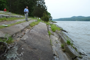
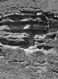
   Thick Normanskill sandstones and thin shales

If you do drive past Mt. Moreno, you might decide to pull over and take a look. The rocks are stratified, and they are largely dark, almost black sandstones and shales. This is the Normanskill Formation. But there is more; there are horizons of chert here too. Chert is better known by the word “flint.” Flint is a shiny dark rock which was used by Indians and other stone-age cultures to fashion into stone implements. You have, no doubt, seen some very fine arrowheads and can appreciate the skill that went into making them.
Flint is an extremely fine-grained rock and that’s why it breaks into small curved chips. An experienced craftsman could pound away at the rock and shape it pretty much any way he wanted, and that includes points, hammers, scrapers and axes. But just saying that the rock is fine grained does not do it justice; there must be much more. That’s where we get to our infestation.
Long ago, in fact about 450 million years “long ago,” our Hudson Valley region lay at the bottom of a very deep marine trench. Do you live in the Hudson Valley? It is hard to believe, but right where you are now was probably 20,000 feet, or more, deep, lying at the bottom of the ocean. Take a look out of your window and see the bottom of the Marianas Trench. Imagine very cold temperatures, strange fish and unbelievable high pressures. But mostly imagine it as not being dark as much as completely black. That’s right here, long ago. The time is called, by geologists, the Ordovician.
This marine deep was called the Normanskill basin and it is a very important part of our geological heritage. A land mass, as large as the islands of Japan, was colliding with North America and the crumpling, associated with this collision, helped make the deep basin. There were no fish, but in every other respect, this was a Marianas like trench.
There were volcanoes and probably many of them. Volcanic eruptions produce silica-rich soot, which can rain down on the seas. There waters would thus be very well supplied with silica (SiO2). That is not especially good for most organisms, but it is very good for radiolarians.
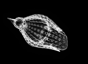
Typical radiolarian
If you have never heard of radiolarians, then you are not alone. They are a group of microbes that are mostly unknown to the general public. You might call them protozoa as they are single celled creatures with animal affinities. They are still alive today and they have tiny skeletons composed of silica.
Silica can be hard to find in sea water, it is not very soluble. But after a sizable eruption, the silica content could sky rocket. Those were the good times for our microbes; they had what they needed to make more of themselves. Volcanic eruptions may very well have been followed by enormous population blooms as astronomical numbers of radiolarians appeared.
None of them lived very long and soon, large amounts of silica skeletons were falling to the bottom of our Normanskill Trench. Thick deposits of them piled up in ever thickening accumulations. Radiolarians might have been very small, but hundreds of feet of radiolarian sediments were piling up.
Burial is nearly forever; these deposits have spent almost the entire last half billion years at Mt. Moreno. They have been deeply buried, under an enormous weight of rock for all of that time. What would you look like after a couple of hundred million years of crushing weight? Well, our radiolarians gradually saw that pressure crush them and harden them into that rock we call flint.
So, now you know a lot more about Mt. Moreno than ever before. Do take a look at those shiny flint deposits along the highway. These rocks had a “previous life” as microbes in a very dark cold ocean.
=============================================================
Contact the authors at randjtitus@prodigy.net. Join their facebook page “The Catskill Geologist.”

The Killer Trees Dec. 18, 018

in Uncategorized by

The Killer Trees
The Register Star
April 29, 2010
Updated by Robert and Johanna Titus

Contrary to the stereotypes, most scientists have rich imaginations and we often like to indulge in wild speculations about our fields of research. Most of the time these ideas can be quickly proven wrong, but sometimes we get an off-the-wall idea that is not so easily eliminated, in fact it may start to look pretty good.
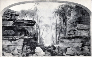
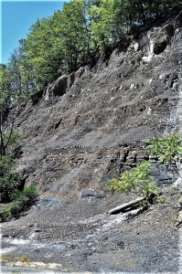
Recently an interesting new hypothesis has been introduced that may offer us a chance to better understand the black shales and dark sandstones of the Catskill sequence. The dark appearance of these strata makes them remarkably eye-catching and they loom, dark and menacing, over the landscapes wherever they are exposed. The best local area is along Rt. 209, just south of the Saw Kill.
  Rte. 209 outcrop
Black stratified rocks are often rich in undecayed organic matter; it’s the black of the carbon gives these rocks their color. This generally suggests to the geologist that there were low-oxygen conditions in the sea waters at the time of deposition. Without oxygen, most decay bacteria cannot function, and they soon die. But why low oxygen? That’s where that new hypothesis comes in.
That new idea is sometimes called the “killer tree hypothesis.” Although the term may seem a little too extravagant, it probably isn’t that far off the mark. The story starts during the middle Devonian when the evolution of land plants was really starting to accelerate. By then land plants had been around for quite some time, but they had only managed to evolve into small forms with thin, weak stems. Nothing that could be called a tree had yet appeared. Trees require wood as support tissue. Not surprisingly, when wood did evolve, large, tall land plants soon followed, and the world’s first forests quickly appeared.


So, what do trees on land have to do with black colored shales in the ocean? Quite a bit, it turns out. Wood had much to do with our story because it allowed trees to grow so tall that they required deep root systems and that’s when we return to the black shale and the poison sea. Complex root systems help to break up bedrock and they greatly accelerate the rate at which bedrock is weathered into soils. Not surprisingly, deep, well developed soils appeared in the Devonian, possibly for first time in history. This was a major transformation of the landscape. Barren landscapes with thin soils were soon replaced by lush foliage and thick soils as our world’s landscapes turned green and blossomed with plants that grew in deep soils.
All of this led to far more rapid rates of deposition in nearby oceans. Thick soils were easily eroded and provided sediments that glutted nearby streams. The sediments were eventually transported into the nearest ocean which was the Catskill Sea. All of this material was rich in dissolved nutrients, materials such as nitrates and phosphates. When these nutrient rich sediments entered the Catskill Sea, they fertilized the water and that led to the next step in what was now a complex chain of events.
The newly fertilized oceans were ideal for algae; they experienced what is called “algal blooms.” Great population explosions of algae occurred in the shallow, surface waters of the Catskill Sea. While all this was great for the algae it was tragic for just about every other category of marine organisms. As the algae died, they were attacked by decay bacteria. The decay process consumed so much oxygen that the seas soon became oxygen-depleted. With the loss of oxygen, bacteria had in effect poisoned their own habitat. Because they needed oxygen too, their numbers soon plummeted and very soon, all types of animals suffocated in the oxygen depleted sea as well. But the algae just kept on proliferating in the surface waters where there was plenty of oxygen, diffusing in from the air. Soon, large masses of undecayed algal material sank to the floor of the ocean. Almost none of this biological matter ever decayed, consequently the sediments that are found there are very rich in black organic carbon. These would eventually harden into thinly laminated, black shales.
When this happens today in a closed body of water, we refer to it as eutrophication. The Catskill Sea was largely isolated from other deep bodies of water. All these conditions promoted what are called thermally-stratified and stagnant waters. The surface layer was hot while, at depths, the lower strata of water remained cool. Dense mats of floating plants and animals grew upon the warm surface waters. Depth stratification and dense planktonic mats prevented agitation and mixing of the waters, causing stagnant sea floor conditions to develop.
Soon a deep basin with a black mud bottom, devoid of life, appeared. Virtually nothing could live in this sea, except at the surface where there was always plenty of oxygen.

Contact the authors at randjtitus@prodigy.net. Join their facebook page “The Catskill Geologist.”

Depths of Depression March. 5, 1998

in Uncategorized by

Depths of Depression
On the Rocks
The Woodstock Times
Updated by Robert and Johanna Titus
Mar. 5, 1998

The sinking of the Titanic is one of the great stories of history. It’s complete with drama, heroism, and even suspense, despite the inevitable ending. Throw in a little romance and no wonder that the current movie has been such a hit. Part of the movie’s success is the allure of the deep. The ocean’s great mysterious abyssal plain retains, even today, a compelling fascination. To scientists, however, equally gripping was the story of the discovery of the sunken liner. You remember it. Intrepid oceanographers, from Woods Hole, Massachusetts, descended to the depths of the ocean’s great abyss in tiny submarines. Powerful headlights shined upon the long unseen sea floor and then upon the wreckage itself. What an incredible moment! The substance of fiction became history.
The depths of the seas had long been shrouded in mystery, and to see actual film from the deep is one of the great achievements of our century, certainly ranking with anything that our space programs have achieved. Much of the abyss is monotonous mud, but there are those many shipwrecks, and a whole exotic ecology of truly wondrous and intriguing animals.
All of this imagery is made even more appealing by the seeming impossibility of traveling to the bottom of the deep sea. Few of us, after all, get invitations from Woods Hole. If you could visit the great abyss, would you leap at the chance, or would you shrink from the real danger of the journey? Would a good movie be enough, or would you have the adventurous streak needed for that perilous trek to the very bottom of the sea? It is dangerous; people have died down there.
Let’s make it easy. We can have you onto the abyss in about half an hour and it will be no more dangerous than a short car ride. Take the Glasco Turnpike east from Woodstock until you approach Mt. Marion. Look for John Carle Road and turn right and head south along it. The path of the road is like that of a sinking ocean liner. First it strays only just a little from its straight path. Then, as if filling up with water, it veers sharply to the left and rapidly descends a steep slope. Near the bottom it lurches sharply to the right and settles, once more, onto a flat floor. And indeed, like a sinking ship, the road has arrived at the bottom of a sea.
There is nothing figurative in our remarkable claim; this is really the bottom of a sea. Or it was. Rising to the right of the road is a cliff of dark black sandstones and shales. These accumulated at the bottom of a deep sea, one that was here nearly 400 million years ago. It can be called the Catskill Sea and the layers of rock you see here were once the muds that made up its bottom.

  Mix of black shales and sandstones

It’s a curious thing, but way back then, the Devonian time period, most of New England was rising into a substantial mountain range. These, the Acadian Mountains, would reach heights of maybe 15,000 feet – perhaps even more! As they were rising, however, the crust of the adjacent vicinities, including today’s Hudson Valley, became depressed. Given time, a fairly substantial deep sea was produced. How deep? we don’t know, but it would have reminded you of the depths of the North Atlantic, a still, mud-bottomed, dark and very silent sea floor.
Much of the roadside exposure is thinly bedded, black shale. That was the mud. Those layers piled up slowly over uncounted centuries. Each thin horizon was once the sea floor. With time another and then another thin seam of mud would accumulate. As the weight piled up the mud was squeezed and hardened into shale. The dark sandstones are somewhat different. These were more active influxes of sediment, moments when masses of sand tumbled into the depths.


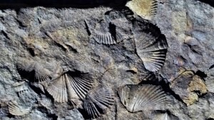
There were living creatures at the bottom of this sea. It only took us a short time to find fossil shellfish here, small animals that spent their whole lives on this quiet sea bottom. No crashing ocean liners interrupted their lives. Scientists did come and visit them, but not until nearly 400 million years after their deaths.

Contact the authors at randjtitus@prodigy.net. Join their facebook page “The Catskill Geologist.”

A pot hole at Hildene Dec. 6, 2018

in Uncategorized by

A pothole at Hildene
Windows Through Time

The Register Star

Oct. 22, 2015
Robert and Johanna Titus

It won’t be long before winter sets in, but there is still time to get out and enjoy. Recently we visited “Hildene” the onetime home of Robert Todd Lincoln, oldest son of the president. That’s south of Manchester, Vermont, off of Rte. 7A. Robert Lincoln had a difficult youth. His brothers died young and, of course, his father was assassinated. Later his mother, who had suffered even more, drifted in and out of madness. Still Robert, in his maturity, made a success of himself in business and as a lawyer. Hildene is the spacious home of a successful man. It overlooks the beautiful Batten Kill Valley.
Our interests were not in seeing any geology; we simply wanted to enjoy a historic site. But, geology always seems to follow us around. We are, especially, unable to escape images of the Ice Age. And that is what happened at Hildene. Someone mentioned something called “Robert’s rock” and we asked about that. It turned out to be a mass of bedrock located immediately adjacent to the south side of the mansion. We looked it over and decided that there was nothing much worth writing about.
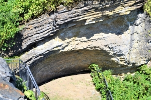
We are always on the lookout for good topics so this was disappointing. But, just beyond Robert’s rock, was a fine view of the Batten Kill Valley below. We stepped forward a few steps and saw one of those ice age features. It was partially buried and had been partially eroded away, but there it was. It was a pothole. Our picture can’t do it justice to it, but there it is.
Potholes are deep, very circular holes in the bedrock. They are the product of swirling currents of water. The currents flow into an eddy. They carry sand and that acts as an agent of erosion. The water and the sand spin and swirl, and the sand bounces against the wall of rock and abrades it. Over the course of time, if the flow is steady enough, potholes will grow deeper and wider. Each one will, however, always maintain the same shape, a circular hole with a rounded bottom. They can be of any size, large or small. It’s not unusual that, when you find one, you find a lot of them.


                                                              Pot hole has scooped out appearance at back of cliff.

We have written about potholes a few times. There is a fine one in the creek in Canajoharie, NY. Then there is a mysterious one at Olana, the home of famed Hudson River artist, Frederic Church. That last one has been reported in the scientific literature and we have searched for it, but without success. Most potholes are found on the bedrock floors of river channels and most of them date back to the Ice Age. Most all of them formed at the end of the Ice Age when massive amounts of meltwater were pouring down river channels. Those powerful currents cut into the earth and exposed the bedrock. Those eddies of water then eroded the potholes into the newly exposed bedrock. Over the millennia that followed, those potholes are likely to have slowly gotten larger.
Do you see a problem here? We did. The pothole at Hildene certainly does not lie at the bottom of a river channel. It is high up on the top of a steep hill overlooking the Batten Kill. That looked to be perhaps 500 feet below. So, what is a pothole doing way up there? We pondered this and debated it, and we soon came up with a solution to the problem; that’s what scientists are supposed to do.
We began to see the Batten Kill Valley as is must have been during the final stages of the Ice Age. We saw the valley filled with ice. We imagine that this must be called the Batten Kill glacier. It had advanced down the valley and perhaps reached quite some distance farther south. But, the climate began warming up and that glacier began melting back. All the time massive amounts of meltwater were pouring off of it.
What an image this generated. We stood there, just south of the mansion upon Robert’s rock. It was about 14,500 years ago and we looked up at a large glacier rising above us. It had been very warm recently and that glacier was melting about as quickly as is possible. An enormous flow of dirty water cascaded down in front of us; it was almost a waterfall. It pounded loudly into Robert’s pothole and swirled into a sizable eddy. We looked down and saw the power of that flow. The walls of the pothole were smooth and shiny from its efforts. Then we went and toured the mansion.
====================================================================================
Contact the authors at randjtitus@prodigy.net. Join their facebook page, “The Catskill Geologist.”

Go to Top