A Real Floodplain. Feb. 22. 2024
At last, a real floodplain!
The Catskill Geologists; The Mountain Eagle; Apr. 26, 2019
Robert and Johanna Titus
We have been writing about valley floors a lot recently. Those are the flat or nearly flat valley bottoms. Typically, people look at them and refer to them as “floodplains.” But we have been finding other explanations and other geologic histories for them. Those valley bottoms that have gentle downstream slopes are likely to be ice age features called outwashes. They are sediments left behind by melting and retreating glaciers. They are mostly mixtures of sand and gravel. We saw a good one near the village of Preston Hollow in a column a few weeks ago. Other valley flats were actually the bottoms of glacial lakes. Many of our Catskills valleys were flooded with water at the end of the Ice Age. Fine grained silts and clays accumulated in those lakes and, after they drained, flat valley floors were left behind. We saw a good example in the valley of Batavia Creek, west of Windham. That valley floor looks like a floodplain, but it isn’t: it’s a very old lake bottom.
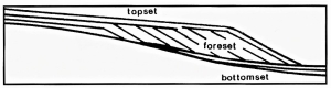
Well, our readers are not shy; soon we received emails asking us where we they could go and see a genuine, authentic floodplain. So, that will be the topic of this column. But first let’s introduce you to what features serve to demonstrate a proper floodplain. And the best of those features is the river meander. A meander is just what the term implies. It is found where a river winds its way around a broad sinuous loop. Take a look at our first illustration (courtesy of Wikimedia commons).
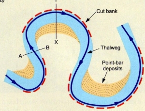
This picture shows a stream channel rounding three meander bends. The heavy dark line shows the deepest, fastest flow of water, called the thalweg. The flow is thrown up against the outside bank where it erodes a steep slope, the cut bank. The sediments on the inside of the meander are called the point bar.
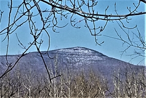
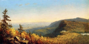
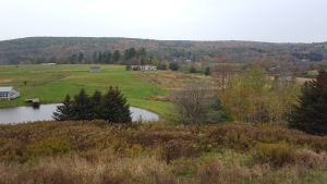
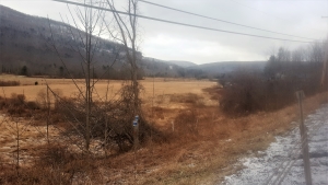
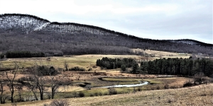
Now that you know some of the terminology of streams meanders, let’s go and look at some. We would like you to take Rte. 23 to Stamford and turn south onto Rte. 10. As you drive south, you will see the West Branch of the Delaware river to your left (east). At about a mile south of Stamford you should be able to see the view on our second illustration. It shouldn’t be too difficult to find a place to safely park and get out to take a good look. There, down below you, is a fine set of meanders. The river heads downstream, turns around and actually flows upstream and then turns around again. All the time it is crossing a floodplain. If you prefer, Google earth can do much of the traveling for you. It will give you an excellent view of these meanders from above.
Now, let’s get to the confusing part. There is no reason, given time, that a floodplain could not develop upon an old lake bottom. There are some fine meanders on lake deposits in the upper Batavia Kill. In fact, we have not been down to the valley flood on the West Branch of the Delaware, and we are not absolutely sure that there is no lake bottom down there. So, a lake bottom is a lake bottom until it becomes a floodplain. And that is something that just takes time. But, as we always say, “this is geology, we always have lots of time.”
_____________________________________________________________________
Contact the authors at randjtitus@prodigy.net. Join their facebook page “The Catskill Geologist. Read their blogs at “thecatskillgeologist.com.”