A visit to an old cement mine. Mar. 28, 2024
A visit to an old cement mine
The Catskill Geologists; The Mountain Eagle May 9, 2019
Robert and Johanna Titus
One of the most sizable among today’s Catskills regional industries is the manufacturing of cement. Its operations lie mostly at Coeymans. It is thriving today but dates back to a distant past. The history of cement in the Hudson Valley began with our country’s entry into the industrial revolution. One of the great projects that heralded our industrial revolution was the building of the Erie Canal. Canals would help make America grow into a great economic powerhouse. But the building of canal systems required a lot of cement; where would it all come from?
Enter an important man, Canvass White. He patented a method for making durable, waterproof hydraulic cement, also known as “natural cement.” That’s a type of cement that, when mixed with water and allowed to set, becomes impermeable to water. It was made from two types of sedimentary rocks: limestone and its close cousin dolostone. When these rock types also have significant amounts of clay in them, then they can be manufactured into natural cement.
In 1825 large quantities of such rock were discovered in and around Rosendale. Canvass White went into the business. He was not alone; by the 1840’s there were a dozen or more cement operations in the Rosendale area. And, for the rest of the 19th century, this industry would only expand; it became big business.
Today, the old Rosendale cement industry is memorialized and partially preserved at the Snyder Estate Natural Cement Historic District which covers about 275 acres. At the heart of this is the Century House Historical Society. They possess 18 acres of land which displays some of the old Rosendale facilities. A visit can be a bit of an underground adventure that we highly recommend.
Coming this Sunday, May 12th, 2019 you can be taken for a tour of the Widow Jane Mine by society member Steve Schimmrich, professor of geology at Ulster County Community College. Steve knows his way around the site. When we joined him there, years ago, he took us to a sizable cliff, penetrated by mine entrances. We entered and found ourselves in what is called a “pillar and room” mine. Way back in the 19th century, miners had excavated shafts into the mountain and then they expanded them until only the pillars were left behind. That allowed the removal of as much cement-producing rock as possible, leaving the pillars to prevent cave-ins. Back then, this was pretty impressive engineering.
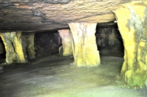
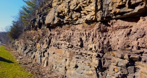
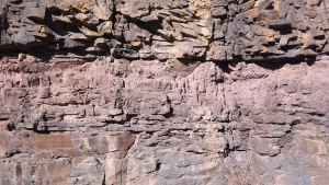
Steve showed us the stratigraphy of the site. The cement producing rock is called the Rondout Formation and it is composed of three horizons of rock: the lower and older Rosendale Dolostone, the middle Glasco Limestone, and the upper and youngest Whiteport Dolostone. The Glasco Limestone was of no economic value, but it was fascinating to see. The Glasco accumulated at the bottom of a very shallow tropical sea and it was richly fossiliferous. Steve pointed out fossil corals that were very common in it. We were traveling abmost 420 million years into the past and looking at Rosendale when it was a shallow tropical sea, dotted with small coral reefs. Steve showed us an abundance of fossil shellfish too. We were thus able to see this ocean and its inhabitants. We saw a wave-swept and agitated sea floor, with an abundance of marine algae and colorful shellfish; it was a wonderful experience.
But it was the other two units of rock that had made all the cement. We looked up at another cliff and saw two horizons penetrated with rectangular mine openings. The lower one was the Rosendale and the upper level was the Whiteport.
Our tour continued, back outdoors, with Steve showing us the remains of the conveyer belt that once carried the dolostone out of the mine to where it was processed. That processing continued in kilns that are still present; there the rock was heated and eventually would be turned into cement.
All in all, the Schneider Estate does a very good job of preserving what it must have been like here when the last cement miner closed up shop and walked away. Time has decayed the site a bit, but it has not destroyed it. The industry began a rapid decline in the early 20th century and the last production ended in 1970. Today all that is left is a well-preserved historic site; our thanks go to the Society for all their hard work.
Contact the authors at randjtitus@prodigy.net.