The Davenport Delta 11-9-23
The Davenport Delta
The Catskill Geologists; The Mountain Eagle
Robert and Johanna Titus
Mar. 23, 2018
Did you ever take a good earth science course – in high school or college? Well, one of the things that commonly comes up is the structure of a delta. Deltas form when rivers or creeks flow into bodies of still water, oceans and lakes. The flowing water currents almost always carry a fair amount of sediment in them. That’s mostly sand, silt and clay. When those currents enter into a lake or ocean they generally slow down. Slow currents can’t carry as much sediment, so a lot of it gets deposited in the form of a delta.
Large rivers, flowing into oceans, tend to form large deltas. Think of the Mississippi Delta. Small creeks, flowing into your town’s skating pond, create small deltas. Big or little, deltas all have pretty much the same basic structure. The advancing front of the delta displays a steep slope that forms the delta’s outer edge. The sediments of this part of the delta display an inclined stratification. Those strata dip toward the lake bottom. The top of the delta receives sediments that are deposited on a flat plane. Those strata are horizontal.
Those inclined strata are called the foreset beds and, on top of them, are the horizontal strata of the topset. The adjacent lake bottom or sea floor, just beyond the foreset, receives a little more sediment, again deposited in flat stratified horizons. These are the bottomset deposits.
Well, in the end, a delta has a flat topset, a flat bottomset and a relatively steeply sloping foreset in between. Here’s the problem; deltas are underwater so we can’t see any of this. But, what if the lake drains, sometime after deposition of the delta? Then that delta would be left high and dry. We can read your minds right now: how can such a thing happen. Lakes don’t drain away, so the deltas will never be visible. Right?
Maybe – or maybe not.
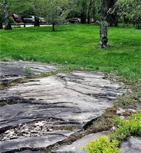
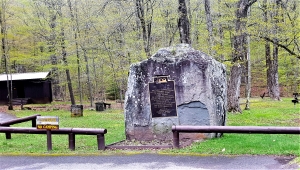
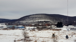
Take a good look at our photo. It was taken just a short distance east of Davenport Center, looking north along Rte. 23. Close to the center of the photo is a house. Notice that behind it, to the left, is a flat surface. Just to its right is a relatively steep slope. At the bottom of that slope is another flat surface (almost hidden by trees). If you didn’t know better you might think that, arrayed right to left, was the bottomset, the foreset and the topset of a delta. But, of course, that can’t be, can it?
Well, if this is not a delta, then it is one remarkable imitation of one. We have a lot of explaining to do, don’t we? That supposed bottomset deposit, is a flat surface that extends quite some distance off to the east. We have done a little exploring there. Whenever we have climbed down to reach this “bottomset” we bring along a barbeque skewer. A what? Yes, a barbeque skewer; it is a very valuable piece of equipment when we are studying ice age deposits.
We drop down onto what we think is an ice age lake bottom and we try to drive the skewer into the ground. If it slides in easily then we know that there are no cobbles or pebbles in the ground. That is typical of lake bottom sediments. We try again with the skewer, and then again and again. If our skewer keeps sliding in, time after time, then we can assume that our flat surface is indeed the bottom of an ice age lake. That’s always a fun discovery. And, better still, this one was a lake with a delta.
Most of the Charlotte Creek Valley was dammed by melting glaciers at the end of the Ice Age. Lakes formed behind these ice dams and so it was that deltas, from time to time, formed in these lakes. We have discovered one of these old deltas. If you have a chance, go there and take a look; see the landscape there as we do.
Contact the authors at randjtitus@prodigy.net. Join their facebook page “The Catskill Geologist.”