
Floodplains? Part One
The Catskill Geologists
Robert and Johanna Titus
We are guessing that you have a pretty good idea of what a floodplain is. That’s the flat surface which stretches from one side of the valley to the other. Right? Well, maybe, and then maybe not. These next two weeks we are going to visit a pair of “floodplains” and find out something very different. Let’s begin.
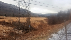
Our first so-called floodplain lies in the valley of the Batavia Kill, next to Rte. 23, just a little west of the town of Windham. Take a look at our photo taken along the highway. You see the very emblem of a floodplain, or so it would seem. This flat surface stretches down the valley almost to Prattsville. And, it is just as flat all the way. If you get a chance, take this drive and see what you think.
So, why is this not a floodplain? We weren’t fooled for even a minute. When we got a chance, we climbed down off the road with a barbeque skewer. That’s a bit of equipment we always carry in the back of the car. We use it when we see valley floors that look like this. We take the skewer out onto the supposed floodplain and drive it into the ground. If it goes in smoothly and all way, we try again, and then even one more time. With repeated successes we become confident that there are no cobbles or even bits of gravel in the ground. The eliminates the floodplain hypothesis. You see, the typical floodplain is composed of sediments carried along by a stream and then deposited during flood events. Fast flowing streams have no trouble carrying gravel and cobbles. Flood events have no trouble depositing them and making a new floodplain composed of course-grained sediment.
But what happened is that the barbeque skewers slid into the ground smoothly. There are no cobbles and no gravel to get in the way. What is there is a combination of sands and silts. Those are the deposits of lakes. Batavia Kill is a long and old lake bottom. We find this all the time and all through the Catskills and Hudson Valley. That’s because there are likely to be lake deposits in all these vicinities. How come?
The answer is that these are glacial lakes that date back to the Ice Age. And, again, how come? We kept driving west along Rte. 23 and we approached the vicinity of Red Falls. Have you seen Red Falls? It’s a pretty cataract composed largely of red sandstones, lying a bit east of Prattsville. It’s worth the trip come warmer weather. Just east of those falls the valley is altogether different. There is nothing that even resembles a floodplain. Instead, great heaps of earth crowd the streambanks. This landscape is called a glacial moraine. That is something with its own story.
We have, once again, gone back to the Ice Age. We look east and we see that the Batavia Kill Valley is filled with ice. One glacier advances from the east while another approaches from the west. On the day that we make our time-travel visit, they are colliding. An enormous pile of earth lies compressed between the two. It’s a heap of earth called a glacial moraine. Our time travel continues, and we watch as the climate warms and the ice begins to melt. Soon a lot of it melts back and the glacier retreats toward Windham. Now that Red Falls moraine is left behind as an earthen dam. And behind that dam lies a growing lake. Let’s call it Glacial Lake Batavia.
Over time, the lake will accumulate a lot of sediment. When it drains that sediment will be left behind as a flat surface, that looks like a floodplain – but isn’t. Let’s do something like this again next week.
Take this drive sometime soon and see how your understanding of the valley has changed.
Contact the authors at randjtitus@prodigy.net. Join their facebook page “The Catskill Geologist.”


