Why Gilboa?
Robert and Johanna Titus
The Catskill Geologists
Sept. 15, 2017
Gilboa was, a century ago, a sizable town in the center of the Catskills. We have been told it was once as big as Cobleskill. But fate struck; New York City reached out and took the land the town was built on, and used that for a reservoir. A dam was constructed just a little west of the old town. The village was razed and, when the dam was filled with water, it disappeared altogether. What little is left, is at the bottom of the reservoir
It was a sad fate, and one which is still deeply resented. But, why did it happen? What was it about Gilboa that led to its demise? We decided to see if we could answer that question. We could not go back through time and travel to the offices where New York City engineers were making their decisions. We could not talk to them, or read their minds. And, much of the geological evidence is now hidden from sight, at the bottom of the reservoir. But, there are other sources of evidence. Perhaps we could read those minds!
We have one of the maps that those long-ago engineers must have used. It’s what’s called a 15-minute quadrangle map of the Gilboa area, published by the New York State Department of Public Works. Ours is the 1903 edition, so it is the very one that those engineers were likely eyeballing as they searched for likely locations for New York City reservoirs. We could look at this map and think as they must have.
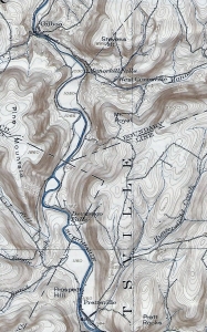
We have selected that part of the map that shows the Schoharie Creek Valley where it stretches from Prattsville, north to the onetime site of Gilboa. That’s where the reservoir went. Take a good careful look. Do you see all those narrow lines? Those are contour lines. They define different elevations. The bottom of the valley was at about 1,050 feet in elevation. If you look carefully, you can see the 1,050 foot contour line, just to the right (east) of the creek.
The bottom of the creek was valley floor flatland. It must have been good farming. Notice the absence of contour lines down there. Flat land has very few, or no contours. But the valley walls are different; there contour lines are closely spaced. A person who, back then, climbed up those slopes would have frequently crossed contours.
Experienced geologists can “read” such maps and learn so much from them. Well, we studied the map and began to see the Gilboa area as it had been, before the reservoir and its dam. We saw that most of the valley floor, all the way south to Prattsville, had been wide and flat. We know that this had been the bottom of something called Glacial Lake Schoharie, and those flatlands must have been lake-bottom silts. Easy to plow, these acres must have been wonderful farmland.
But look where Gilboa was; there the contour lines crowd the valley floor. That’s where the Schoharie Valley had been surprisingly narrow. Those long ago engineers must have seen the potential. Gilboa was located right where the valley was narrow and easily dammed. Behind that planned dam, was a wide valley with a flat floor.
The Gilboa site was ideal for damming; the lands behind that dam would be perfect for a reservoir. Gilboa’s fate was sealed; the town was doomed; the town was damned!
Contact the authors at randjtitus@prodigy.net. Join their facebook page “The Catskill Geologist.” Read their blog at “thecatkillgeologist.com.”