Vroman’s Island
The Catskill Geologists Sept. 2017
Robert and Johanna Titus
We do a lot of poking around, here in the Catskills, and we wind up learning the darndest things about the area’s geology. Let’s do one of those in this week’s column. Let’s start by taking you to Middleburgh. Some time ago we described the fact that the bottom of the Schoharie Creek valley, south of town, is underlain by the silts and clays of an old ice age lake.
About 14,000 years ago, the whole valley here lay beneath the waters of that deep lake. It has been, logically enough, called “Glacial Lake Schoharie.” The flat valley floor, hereabouts, is the bottom of that lake. Most of the time, the waters of a typical lake have a drain which takes them on a journey toward the nearest ocean. Geologists have discovered that the Lake Schoharie drain passed down the Catskill Creek Valley on its way to the Hudson drainage basin. Today Rte.145 follows this path. If you get a chance to drive down this valley, we would like you to imagine the powerful whitewater torrents that once filled up all of its lower parts. Those waters had been in Lake Schoharie, but they had poured into today’s Catskill Creek.
The top of the Catskill Creek Valley lies at an elevation of 1,180 feet at the Village of Franklinton. That level formed a dam for the waters of Lake Schoharie. When Geologists look at the Schoharie Creek Valley, in their mind’s eyes they fill it up to the 1,180 foot level. The floor of the valley lies at an elevation of about 640 feet so, if you do the math. Okay, we will do it; the lake was 540 feet deep! That’s a lot of lake; the next time you are driving south from Middleburgh, look up and imagine all that ice water rising above you.
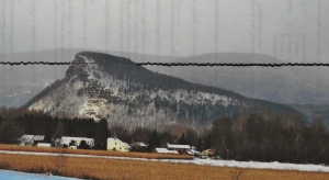
Well, we had figured all this out and that was when we got to that “darndest” thing. We were looking at our Middleburgh topographic map over, and we noticed that Vroman’s Nose rose to an elevation of about 1,250 feet. Have you ever hiked to the top of the Nose? We hope so, Vroman’s Nose is a hill that is found a short distance southwest of Middleburgh. It looms above the valley floor. It is a very distinctive landscape feature with a towering cliff facing the south. If you have been up there, then you have seen the absolutely wonderful view from that top.
But we had made that darndest discovery. The top of Vroman’s Nose rises about 70 feet above the old lake level. That means .that way back then, this was not Vroman’s Nose; it had been Vroman’s Island.
We hope you will get a chance to visit Vroman’s Nose sometime soon. It’s a town park now and open to the public. You can take one of their trails to the cliff that lies near the top, Today, you can enjoy a wonderful view of the valley spread out in front of you. But we hope you will summon up your mind’s eye, and see the vastness of a very sizable lake out there.
Contact the authors at randjtitus@prodigy.net. Join their facebook page “The Catskill
geologist.” Read their blog “thecatskillgeologist.com.”