"I will never kick a rock"

Monthly archive

November 2021

Glasco Pike #5 – The Catskill Delta

in Uncategorized by

The Glasco Pike #5: How long is time?

On the Rocks; The Woodstock Times

Updated by Robert and Johanna Titus


The one thing that geologists can truly claim is that we have a very well-developed understanding of the vastness of time. We deal in enormous amounts of time all the, well, time! Today we continue our own journey through the eons, one that has taken us along the Glasco Turnpike. We are looking at the history of Woodstock and all of Ulster County as it was during Devonian time, a little less than 400 million years ago.

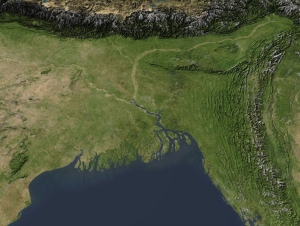
Last time, we had reached a point one mile west of the Plattekill Bridge. There we saw a petrified river channel. We had entered into the realm of the Catskill Delta. That’s a great delta complex of the Devonian age; it is comparable to the Ganges Delta of today’s Bangladesh. Now we continue westward along the Glasco Turnpike on a journey which will carry us toward Overlook Mountain.

This trip of several miles will carry us uphill about 500 feet, but it will also carry us “uphill” through time. As you head this way as you pass the occasional outcrop of bedrock. For the most part these rock exposures are of sandstone. It’s the type of sandstone that we, around here, call “bluestone.” Each of these ledges is similar to the outcrop we saw in our last installment; they are all Devonian river channel deposits.

But there are so many of these deposits; it leads to a simple question: how can there have been so many rivers in the Woodstock area way back during the Devonian? And, as we learn more, the mystery gets even better. All of these ledges have a gentle incline to them; they dip to the west. That means that if we drive down the highway and pass one ledge and soon pass another, then we have, in fact, passed two successive ledges in a stratigraphic sequence. There is a sequence of inclined ledges arrayed down the highway. Each ledge represents an ancient river.

What this means is that, through time, many successive rivers flowed across the Catskill Delta. The delta, like today’s modern Mississippi Delta, was constantly sinking. As the old delta surface subsided, new rivers would flow across new surfaces, carrying with them new deposits of sand to make new bluestone. Try to appreciate this as you pass the many ledges along the Glasco Turnpike. You are passing through a stratigraphy, and you are passing through time, a lot of time.

That has been the point of our whole series of visits along the Glasco Turnpike. We have used this highway to make a journey, a Darwinian journey, through time. Let’s make a few stops or at least slow down a little.

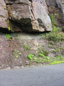
Just 7/10’s of a mile west of the Rt. 212 intersection is an outcrop that displays a nice example of a river sandstone, which lies immediately above a fossil soil horizon. This is what happened there. There had been a delta plain surface which, over a period of time, developed a good thick soil. Then, probably very gradually, the delta plain subsided. A nearby river jumped its old channel, moved here and eroded its way into the soil that we see here. For a long period of time that river flowed this way and then, at a much later date, it jumped its banks and moved somewhere else. While at this location all the sands of the ledge you see accumulated.

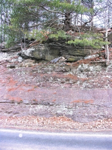
Keep going west and just 1/10th of a mile west of Plochman Lane is another fine outcrop. The lower 2/3rds are made of strata of red silty sandstone. These might be considered as more fossil soils; they would remind you of Georgia red clays. That is pretty much what you would expect, considering that this was a tropical climate way back then. The rest of the outcrop is another river channel.
At Meads Mountain Road you can turn and drive uphill. If you wish, you can stop at the trailhead for Overlook Mountain. From there you can hike up to the top of the mountain. All the way, you will continue to pass more ledges of river channel bluestone. Commonly you will see more horizons of red fossil soils. You are traveling upwards through the sediments of the Catskill Delta, once one of the world’s great delta systems. You are watching as it gradually subsided and gradually accumulated more sediment. That took a lot of time.

And, once again, that is the whole point of our journey. We have traveled, these past five chapters, from Glenerie to the top of Overlook Mountain. We have watched as a shallow tropical sea came to deepen into an abyss. Then we watched the waters shallow again and soon a huge delta complex overwhelmed the whole Catskill region. From the top of Overlook Mountain, we can gaze back towards Glenerie and now have a real understanding of what the rocks between here and there represent. We have an inkling of the enormous amount of history that has unfolded before us. Now we also have an inkling of how long is time.

Contact the authors at randjtitus@prodigy.net. Join their facebook page “The Catskill Geologist.”

The Glasco Pike #4 – A Fossil River

in Uncategorized by

The Glasco Pike #4: A Fossil River

On the Rocks; The Woodstock Times

Updated by Robert and Johanna Titus


We have been exploring time itself over the course of the past several columns. Physically, we have been moving westward along the Glasco Pike. But, in terms of time, we have gone back to the early Devonian time period and have been moving forward. Our goal is to look at our local geological history in the way that geologists see it. We are looking at several million years of time and history. This is history that took place during the Devonian time period. Young world creationists do not believe in the Devonian. They commonly attempt to fit their view of geological history into the catastrophe of the Noah’s Flood. Our job is not to criticize that but to explain the point of view of geologists. Let’s continue our journey.

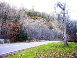
We are going to drive about a mile west of our last stop where the Saw Kill crossed the Glasco Turnpike. We will climb a hill and then, to the right, is a fine ledge of rock. Parking is tricky here and we don’t want anyone to be hurt so use good judgment. You might just glimpse and run. It’s best to view the ledge from across the highway. When you do so then you can begin to see what these sandstones represent. They make up a fine cross section of an ancient river channel. Take a good look; you will see the channel is deepest in the middle and it shallows both left and right.

This is a petrified river. That is likely to be a novel idea for most of you. There are petrified trees and petrified dinosaurs, but a river? Who has ever heard of such a thing? Well, Catskill area geologists have, and they have heard of a lot of them. When we left off last time, we were watching the Woodstock area as it was rising out of the sea. Our view of the outcropping along the Saw Kill showed a shallowing sea. The strata at the top of that outcrop formed near the ancient shoreline. If that interpretation is correct then it cannot be much of a surprise that younger, overlying rocks should display evidence of having formed in a terrestrial landscape. What is more “terrestrial” than a river?

We have entered into the realm of the great Catskill Delta. It is a petrified delta and there we encounter another one of those surprising phenomena. Yep, there are petrified trees and maybe petrified rivers but a delta!? Look out the window and up into the Catskills. Try to imagine that the whole thing is a petrified delta. Kind of changes your perspective on things, doesn’t it?

The best way to come to understand the Catskill Delta is to get out a good map of Bangladesh. That Asian nation has been developed upon the Ganges River Delta. A good map will show a landscape dominated by scores of rivers, big and small, all emptying into the Bay of Bengal. Our little petrified river was very similar; it was one among scores of rivers crossing the Catskill Delta and emptying into a body of water called the Catskill Sea. Our river’s waters had descended down the slopes of the Acadian Mountains: a great range of mountains in what is today New England. Mountain streams had eroded into the Acadians and turned a great deal of mountain into sand. Our river had carried a lot of that sand as a channel deposit. See top of our first photo.

When you look at a river, it appears to be something that will last forever. Who can possibly imagine the Saw Kill or the Esopus Creek not being where they are? But rivers don’t last forever; someday even the Hudson will disappear. It’s easier to lose a river on a delta. There rivers have a habit of jumping from one site to another. During great floods, a river can be diverted of to a new direction, leaving its old channel abandoned. This is, no doubt, what happened to our little petrified river. Its flow of water jumped to a new site and went in a new direction and the old channel sands were left to slowly petrify. All memory of that river was lost until geologists came along and recognized what is there, along the Glasco Turnpike.

Charles Darwin is remembered mostly as a biologist, but he was a very good geologist as well. He would have understood the story of the Catskill Delta and this view of rocks would have fit very nicely into his mindset.

Young Earth creationists will likely have a problem here. If the Catskills are a great petrified delta, then that is something that must have taken an enormous amount of time to have been deposited. A mere 6,000 years is not going to be enough time, geologists think that it took many millions of years. And that is the point of this whole series of columns; We am laying out the evidence. We report and you decide!

Contact the authors at randjtitus@prodigy.net. Join their facebook page “The Catskill Geologists.”


The Glasco Pike: Rising out of the Sea Nov. 6, 2021

in Uncategorized by

Retreat of the sea

On the rocks, The Woodstock Times.

Robert Titus


Charles Darwin’s great theory is based upon two of the fundamental concepts of geology: first, the Earth is a very, very old, very slowly changing place and, second the fossil record has been gradually changing throughout all that vast length of time, with primitive creatures coming first and more advanced forms coming later.

We have been journeying down the Glasco Turnpike with the intent of testing these notions to see if Darwin was right. If he was right, then our explorations into the distant past should bring us to very different images of the Woodstock region from that which we know today. We should find a fossil record which reveals very different plants and animals from those of today’s Ulster County.

So far, so good: these rocks are a little less than 400 million years old, and they speak to us of a slowly changing Ulster County. Our first stop brought us to the shallow tropical seas of the Helderberg Limestone. We saw bedrock composed of lithified sedimentary limestone that had accumulated on the floor of something very much like today’s Bahamas. Our second stop, at the Bridge that crosses the Esopus Creek, at the eastern end of the Glasco Turnpike, showed us the same ocean after it had become much deeper and very stagnant.

Our journey, today, has taken us west to just across the Plattekill Creek. Towering above the highway is an almost magnificent outcrop. It rises a hundred feet or more above the Plattekill. The lower half of the outcrop is composed of very dark shale. Above that are a number of lighter colored, thick strata. All these strata belong to something called the Mount Marion Formation, which makes a lot of sense as that mountain rises above us at this site. This thick sequence speaks to us of a very important chapter in the history of the Woodstock region.

Those black shale beds, at the bottom of the outcrop, tell us about the moderately deep water, very quiet sea that was once here. Try to imagine a very dark, very still sea bottom. Current activity is rare, so silt and clay particles have no trouble settling to the bottom. That’s the stuff that has hardened into the dark shale. There was nearly no oxygen in the sediment and that is why it is so dark. Black is the color of carbon-rich biologic material which is all that is left of most of the few animals that once lived here. Oxygen, in the sediment, would have destroyed that dark stuff and bleached the rock, but there just wasn’t very much of it.

That absence of oxygen was important. It was too deep and dark for any plants, so they didn’t make any. It was too quiet for currents to sweep oxygen downwards from the air above so, all in all, this was nearly an oxygen-free habitat. That’s likely why fossil shellfish are so uncommon here; I remember finding a few ten years ago when I last searched this location, but I found none this time.

How deep is deep would be a fair question. But we geologists get really evasive when asked that one. It is not easy to come up with a good estimate. We would guess a few hundred feet, but another geologist might come up with a very different “guestimate.” We don’t know!

It’s the upper half of the outcrop where things get a lot more interesting. If you look up there carefully you will see a number of much thicker strata. We weren’t ready to scale these heights, but we strongly suspect that these beds are thick sandstones. Usually this is the product of moments of depositional excitement. Something, probably a major storm, stirred up the old seafloor and transported large quantities of sand far enough offshore to get here. After this curious event, things settled down and more dark shale was deposited.

The fact that these sand beds are found only in the upper half of the exposure suggests strongly that this was a shallowing sea and that the shallowing was associated with an advancing shoreline. As the shoreline approached and the waters shallowed, it became easier for storms to stir things up here and to form those strata of sand. We call such a shallowing sequence a “regression.” The sea was literally draining away.

We are not used to seeing regressions in modern times. The glaciers have been melting and, worldwide, the pattern has been one of rising seas over the past 10,000 years or so. We live in a time of transgression and that just, to us, seems to be normal. But, in the distant past, things were often different. Earth history presents us with as many regressions as transgressions. In the Glasco Turnpike is showing us one of them.

But there must be a bigger picture here. There must be a lot more to the story. There is. Next time we will rise out of the sea.

Reach the authors at randjtjtitus@prodigy.com. Join their facebook page “thecatskillgeologist.”

Go to Top