"I will never kick a rock"

Monthly archive

August 2018

Inspiration Point in Kaaterskil Clove Aug 30, 2018

in Uncategorized by

INSPIRATION POINT
On the Rocks
Oct. 17 1996
Updated by Robert and Johanna Titus

It doesn’t take much to get a geologist to go outside, but in autumn we find ourselves ever more drawn outdoors, especially as the season progresses. There is something compelling about the annual foliage scenery. There are only so many leaf seasons in a lifetime and to waste or miss one seems a sin. Each is something to be savored.

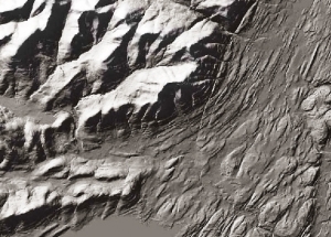
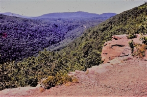
There are special places in the Catskills which we like to visit at any time of the year. One of those is Inspiration Point in Kaaterskill Clove. The site has been a favorite for Catskill hikers for more than 150 years, and there’s good reason. Inspiration Point towers above the rim of Kaaterskill Clove, a place which has often been referred to as the “Grand Canyon of the East.”


Take Rte. 23A to Haines Falls and turn east onto County Rt. 18. Turn right on Laurel House Road, and park at the end of the road. The new dirt trail will lead you to Kaaterskill Falls. But we want you to find the Blue Trail. (get a hiking map of the North Lake vicinity.)
The Blue Trail takes you south to the Layman Monument. Poor Frank Layman died there early in the 20th Century while he was fighting a forest fire. They have cut the foliage there so that his monument has a fine, but distant, view of Haines Falls. Beyond the monument, the trail turns east and soon brings you to the brink of Kaaterskill Clove itself. If you have not been here before, be prepared for a great surprise; Kaaterskill Clove is a lot bigger than you imagine. It’s about three miles long, a mile wide and a thousand feet deep. The slopes are steep, dropping those thousand feet in less than one half mile, and the visual impact of this makes the clove seem bigger than it is.

On an autumn day the clove is at its best, deep, rugged and picturesque. Hike eastward and the Hudson Valley soon comes into view. Continue along the blue trail and you soon pass some large rocky knobs which caught the eye of Thomas Cole. The renowned Hudson Valley artist painted at least one canvas right here. So did Sanford Robinson Gifford.

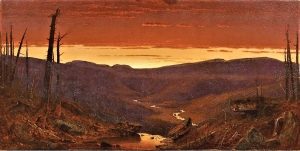
There is of course a geological story here. The great canyon is a relatively new landscape feature. A hundred thousand years ago, or so, the Hudson Valley was glaciated, filled to the brim with a stream of ice called the Illinoian glacier. This river of ice passed the escarpment of the Catskill Front which was, back then, unblemished by any large canyons. Only after the ice melted did Kaaterskill Creek form and start to erode its deep canyon. That makes the clove less than 100,000 years old. Big as it is, the clove is extremely young by geological standards.

Inspiration Point is just a little farther down the clove. Look for a fine platform with a cliff in front. People have found this the best place to take in the clove’s view. Landscape artists have seen the same. But Geologists have discovered that this is the best place to understand the glacial history of the clove. Look at that platform carefully; it has been scoured by the passing ice into a beautiful smooth polished surface. It’s only marred by the striations gouged into it by the passing ice. The cliff here is the product of glacial work. It faces westward and was formed when great masses of rock were broken loose and plucked away by the passing and westward moving ice.

About 18,000 years ago the Hudson Valley witnessed another glaciation. Once again, a great stream of ice, the Wisconsin glacier, flooded the valley. This time some of the ice branched off and flowed westward up Kaaterskill Clove. This stream of ice would not stop until it reached nearly to Prattsville. It’s this ice that made Inspiration Point.
Gaze down to the bottom of the valley and then to the other side of the clove. Look up and down the valley. When you realize that all this was filled with moving ice you begin to get a sense of just how great an event this glaciation was. For a century and a half hikers and artists have come here to marvel at the landscape as it is; geologists come here and marvel as to how it was.
===================================================================
Contact the authors at randjtitus@prodigy.com. Join their facebook page “The Catskill Geologist.”
Figure captions

Dinosaurs in Woodstock??? Aug. 22, 2018

in Uncategorized by

Jurasstock Park

On the Rocks

Robert Titus

Woodstock Times

July 3, 1997

I went and saw Jurassic Park recently. I happen to be a paleontologist, so I thought that it was about time I saw the kind of life that I should be leading. The movie was a lot of fun and there was plenty of action and adventure. There were good-guy paleontologists and bad-guy paleontologists which is an angle I had never reflected upon before. I have enjoyed my own career in fossils very much so far, but it is clear, from this vicarious experience, that I have missed out on a lot of excitement. Chasing fossil brachiopods is just not the same as being chased by a Tyrannosaurus.
If you see the movie you may wonder what it was like here in Woodstock back during the Jurassic. The answer is that we don’t know. There are no Jurassic age rocks in this area. No rocks/ no history is the way it works in Geology. Nevertheless, it is fair to speculate as to what it was like around here way back then. And, in fact, there are some Jurassic age rocks not all that far away. They can tell us a lot.


It was the Jurassic and the earlier Triassic times that witnessed the origins and early history of the dinosaurs. In New York State there are late Triassic and early Jurassic sedimentary rocks in Orange and Rockland counties; there are more in central Connecticut. Only a few fossil dinosaur skeletons have been found in these sequences, but the strata are just crawling with dino footprints. And there is an especially interesting species of dinosaur whose footprints are quite common in these rocks, a dinosaur that certainly once lived here in Woodstock. Its Latin name is Coelophysis, and it was a very fine specimen. It belonged to a group called the ostrich-like dinosaurs. Coelophysis wasn’t especially large, being only five feet tall and nine feet in length. It was, however, remarkably athletic. They were agile and light-weight, weighing in at a little more than 100 pounds. It’s probable that they were among the earliest predatory dinosaurs. Coelophysis had small forelimbs, but they were armed with long recurved claws. Its large mouth possessed numerous, knife-like teeth. All in all, the animal would have been quite effective at ripping its prey apart, making it an excellent movie monster.
But that’s wasn’t the scariest thing about this dinosaur. There are sites in New Mexico where their skeletons are so abundant that paleontologists have speculated that they must have hunted in packs. That really gets us to the Jurassic Park stereotype of dinosaurs as vicious marauders. And there may be a great deal of truth to the stereotype. I once saw a series of dinosaur trackways. They were all the same species, all the same size, they were spread out evenly, and all heading in the same direction – a skirmish line of predatory dinosaurs! I had 15 of my students place their feet in the tracks and, on signal, they all stepped forward, laughing, growling and retracing those 190 million year old trails. Dinosaurs can be fun, at least the dead ones that can’t eat you are fun.
Coelophysis likely did live here in Woodstock and dinosaurs are part of our local geological heritage. It’s too bad we can’t go out and hunt their bones. I don’t know if there ever were any Jurassic age strata in Woodstock, but if so, they would have eroded away millions of years ago. All evidence of local dinos has been gone all that time. Want to see some real dinosaur fossils? Travel to Dinosaur State Park, near Rocky Hill in central Connecticut. There is an outdoor display of footprints there. Maybe one of the dinos that left its footprint in Connecticut came from Woodstock.

Fossil rain drops? Aug. 16, 2018

in Uncategorized by

Raindrops
On the Rocks
The Woodstock Times
Mar. 20, 1997
Updated by Robert and Johanna Titus

We encounter many natural wonders in this field of geology and too often we take them for granted. There are so many things preserved in the rocks that really should not exist. Dinosaur footprints are good examples. How could something as ephemeral as a footprint in the mud be preserved 100 or 200 million years after they formed? The answer is that they really shouldn’t; it’s a one in a million chance. But what if there were ten million dinosaur footprints? Then ten of them would be preserved. If there had been a hundred million dinosaur footprints, then a hundred of them should still be around. One in a million shots become certainties if you just play the odds.
And geologists must learn to play the odds. Pretty much all of the fossils we find were originally one in a million shots. They were bones or shells or tree trunks that defied the odds, got buried, hardened into rocks and were found. And then, when you have a million fossils, one of them is truly a grand discovery: a complete dinosaur skeleton, a mastodon frozen in the tundra, a little frog in a piece of amber and so on. Search for fossils long enough and you beat the odds.
We are used to this, but there are still things that we have a hard time believing, even if we see them ourselves. One of those odds-defying oddities can be found right here in the Catskills. They actually aren’t fossils, but the word fossil can be used to describe them. They are raindrop prints, often called “fossil” raindrop prints.


                                                                        “Raindrop prints” scattered across surface

What could possibly be more ephemeral than a raindrop print? The drop falls out of the sky and leaves an impact crater in the soft earth. The crater is just that, a soft rim of earth thrown up by the impact. So far, so good, but how can something like this come to be preserved? Isn’t it likely that the very next drop will destroy the crater left by the last one? The answer is yes, of course, and the next 100 or 1,000 drops will also destroy any craters left about. And after the storm, won’t the earth be too soft to preserve an impact crater? Of course it will, the ground should be all mud, too soupy to preserve any such features. And even if a raindrop print were to survive, wouldn’t wind eventually blow it away, wouldn’t animals step upon it, wouldn’t plants grow through it? Wouldn’t this and wouldn’t that! The answer is yes, yes, yes, the raindrop should be destroyed.
And yet, there they are, . . . preserved in rock . . . little, bitty structures that look exactly like . . . raindrop prints! So, how did they get there? The prints are found on the surfaces of beds of red shales which are thought to have once been soil surfaces. That’s a helpful hypothesis and it adds some plausibility to the story. But, shouldn’t the prints be lost in a mush of mud? To avoid that you have to imagine a very brief shower. A few drops sprinkle the landscape and then the “storm” is over, hardly before it had begun. But what about preservation? Next you have to let the soils dry out. This doesn’t turn it into rock, but dry soil is stiff enough to resist distortion. Finally, you want a flood to occur and submerge the flood plain. Floods are often not as catastrophic as the evening news coverage would suggest. Flood waters can often rise rather passively and bring blankets of new mud to bury the old soils. That can be done without much disruption of the rain drop prints. Continue this process for a very long time, bury the prints in a deepening thickness of sediment, and it will harden into rock. With that the raindrop prints are preserved. It’s a long shot, a very unlikely sequence of events, but it is possible, and it does happen. And that’s how it is that we can go and find such remarkably unlikely features in the rocks.
Such things are called primary structures. They are rather fun to watch for and they tell us so much about what the rocks represent. We would like to tell you where to go and find some raindrop prints, but that is hard to do. Look for red shales and these are common throughout the Catskills. Then pick through the shards of shale. If you are lucky you may find some. If you are not lucky, well maybe next time.
=================================================================
Contact the authors at randjtitus@prodigy,net. Join their facebook page “The Catskill Geologist.”

A lot to Overlook – Aug. 9, 2018

in Uncategorized by

Halfway measures
On the Rocks
Feb 13, 1997
Updated by Robert and Johanna Titus

We usually think of mountains as emblems of permanence. “Old as the hills” is certainly a common enough old chestnut. It implies that the hills (and mountains) are just going to be there forever and ever.

That may not be. George Halcott Chadwick found it otherwise. Chadwick was one of the great Catskill-area geologists of the first half of the 20th Century. He spent a lot of time looking at regional maps and he gradually came to the conclusion that the eastern Catskills are, quite literally, not all there. Take a look at a good regional map. Kaaterskill and Plattekill Cloves divide the Catskill Front into three east-west ranges: the Jewett Range in the north, the Roundtop-High Peak range in the center, and the Sugarloaf to Plattekill Mountain range in the south. Each of these three ranges is sharply terminated on the east by the steep, straight slopes. It’s as if something had chopped off those eastern parts. The three eastern slopes are called “truncated spurs” and together, they define the “Wall of Manitou” of the Catskill escarpment. The “Wall” is a straight, ten-mile long front. Chadwick found that to be remarkable; he thought that the truncated spurs and the steep, straight nature of the wall required some unusual erosional processes to explain them. He believed that it was glaciers which did the job.


The story begins a bit more than 100,000 years ago when there was an event called the Illinoian glaciation. A massive glacier, advancing from the north, seems to have descended the Hudson Valley and gradually filled it. Picture a stream of ice, at least to the brim of the valley and probably a lot higher. In many ways it behaved like a river, the ice slowly flowed down the valley. Now some sort of a Catskill Front had already existed, but it probably wasn’t the steep straight wall that we know today. More likely, gentle slopes descended gradually, well east of today’s wall. In fact, Chadwick thought the slopes may have reached out one or two miles into the Hudson Valley. That included Overlook Mountain which would have been, Chadwick thought, about twice its present size.
The passage of the ice had an erosive effect upon the old slope. Moving glaciers pluck and grind away at landscape’s bedrock. The ice likes to carve a steep-walled trough and that’s what the Illinoian glacier set about doing. The lower slopes of the Catskill Front were largely composed of soft shales and these eroded easily. The upper slopes were of resistant sandstones and these put up much more of a fight. Given time, the steep slopes of the Wall of Manitou were the result. But not before quite a bit of Overlook (and the rest of the Catskill Front) was worn away.
With the return of warmer climates, the Illinoian glaciers eventually melted but the respite was brief. About 25,000 years ago the climate deteriorated again and once more a stream of ice flowed down the Hudson Valley. This has been called the Wisconsin glaciation. The whole process was repeated and again the Wall of Manitou suffered even more erosion.


This had a real effect upon Overlook. We described the final stages in the process in a Times article last August (1996). The steep ledges up there date back to those last moments of glaciation. In the end, after the Wisconsin glaciers retreated, Overlook Mountain was literally half the mountain it used to be. Fully two miles of eastern Overlook were gone. It’s quite a thought, half a mountain lost. That is, if Chadwick was right.
George Chadwick’s story is a fine one and we are very fond of it. We hope that it is true, but the hypotheses of science are not always so simple. Sadly, there are modern geologists who very much doubt that this is what happened. They just do not think that passing ice is capable of removing so much rock. One of the problems with their objections, however, is that they don’t have any better ideas. So–is Overlook a whole mountain or is it half a mountain? That is the question.
==================================================================== Contact the authors at randjtitus@prodigy.net. Join their facebook page “The Catskill Geologist.”

The Worm turns Aug. 3, 2018

in Uncategorized by

The Worm Turns
On the Rocks – The Woodstock Times
June 26, 1997
Updated by Robert and Johanna Titus

On Rt. 9W, at Glenerie, the Esopus River descends two ledges of rock known as the Glenerie Limestone. These ledges make up what are either high rapids or low waterfalls, depending on your point of view. In any case they also make a very nice setting and the shores of the Esopus there attract a lot of people. We sat on the banks for a while and watched people go by. There were two fishermen, who had no luck. A couple walked by with their dogs. Several young boys came by on their bicycles. One elderly man wandered along the shore, we think just for the pleasure of it.
Such is life for human beings who are not at work, but just intent upon enjoying a little leisure. The Glenerie Falls provides a setting to idle away a few minutes or a few hours. As I sat along the Esopus, we was watching just a few random moments in the history of life. Nothing special occurred, nothing historic or even meriting the slightest of note. Most of what goes on in this world is like that. Little that happens is really of very much significance. Such is life.
It’s easy to forget that this spot has always been here. The world is four and one half billion years old and this precise longitude and latitude has been here all that time. What was it like here a century ago? We don’t know, but with the help of a historian we could easily guess. How about 500 years ago? A little harder, but good guesses might come from an Indian archeologist. How about a million? or a hundred million? or a billion years ago? Even a geologist has a hard time answering those questions.
So much of earth history slips off into the past without leaving any monument or even a clue as to what had transpired. But none of these moments is likely to have amounted to much, just simple events during average times. Countless living creatures have passed by the Glenerie Falls site and almost all are gone and have been entirely forgotten by history. Disappearing into the oblivion of the past is a sad fate that we all share eventually. . . almost all.
But sometimes, hundreds of millions of years after their deaths, signs of the lives of ancient creatures return to light. And we mean that very literally. Memories of ancient organisms are often revived when weathering and erosion of bedrock brings to surface the evidence of lives long lost. We geologists call these “trace fossils.” They are not the bones or shells of ancient organisms, but the evidences of ancient activity, the very behaviors of the past. The best known trace fossils are dinosaur footprints. People have marveled at them for more than a century. They forget that these “marvels” are only evidence of the most every day and literally pedestrian moments in the lives of dinosaurs. Unfortunately we don’t have dinosaurs or their footprints anywhere near Woodstock. But we do have other trace fossils.
A lower ledge of the Glenerie Limestone forms the lower cataract of the falls. The rock is tough and brittle stuff and it has held up well against the elements. On the bank, just below Rt. 9W, this ledge has been brought to the surface by folding of the bedrock. The upper surface of the inclined stratum is a fossil wonder. It’s densely littered with the trace fossils of worms that lived here about 400 million years ago.

The animal has a name – it’s Zoophycos. It was a common marine worm, much like many that live today. You probably know that earthworms make their living by burrowing through soil, consuming and digesting it as they slowly move forward. Similarly, Zoophycos burrowed and ate its way through the marine sediments, including the limestone sediments of the Glenerie. Zoophycos was extremely meticulous in the way it dined on sediment. It burrowed forward for a while, its path taking it in a broad, round loop. The worm then turned abruptly and returned, closely paralleling its first path. Then, once again, it turned on a dime and paralleled its second path. Back and forth it continued, carefully consuming all of the sediment. Eventually the back and forth path took on the form of a rooster tail and that is the common name it goes by. “Rooster tails” are common throughout the marine sandstones and shales of the Catskills, but this is the first time we have seen them in a limestone. They are fascinating fossils and marvelous insights into the details of ancient life, but they record such mundane moments: Worms eating mud!
If you carefully examine this ledge of rock you will be surprised at how densely burrowed it is. A large population of these worms must have lived here. To survive on a limited food resource, they had to evolve the careful feeding patterns that we see. We doubt they missed anything. There is, we suspect, a message here.++

Go to Top