"I will never kick a rock"

Monthly archive

March 2018

Glacial geology of Stony Clove – March 29, 2018

in Uncategorized by

Clove encounter

On the Rocks

The Woodstock Times

April 10, 1997

Revised by Robert and Johanna Titus


It can often be difficult to teach a science, even one as interesting as geology. Many people are adverse to the sciences. One problem is that a lot of people really would rather not know the technical details behind some remarkable piece of nature. They believe it’s better to harbor romantic images and not spoil them with harsh factual science. Let’s try this out at Stony Clove.

Stony Clove is a magnificent sight to see. It is a very steep, very narrow notch in the Central Escarpment of the Catskills. It is a remarkably scenic location, especially in the autumn when the leaves are in color and when the lake there reflects their image. A person might very well be tempted to not want to know too much about the notch. How could the science improve upon such natural beauty?

Maybe science is the wrong word to start out with. A better word is mystery. What is this wonderful notch and how did it come to form here? That sounds better, and if the mystery of Stony Clove catches your interest, then it must be the science of the site which will solve that mystery. Certainly no geologist can pass such a landscape feature without wondering how it came to be, and there is quite a story behind the notch, one that takes us back into the ice age.

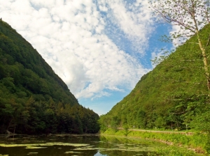
When you get a chance, travel to Stony Clove. As you approach the top of the clove on Rte. 212 from the south, there is a lake to your left. Beyond that is the clove. Park in the lot next to the lake and hike north to the top of clove. In your mind’s eye go back 17,000 years. It’s a time in the history of Catskill Mountain glacial history called the Wagon Wheel Ice Margin. From the Hudson River, valley glaciers have advanced up Plattekill and Kaaterskill Cloves. Some of this ice has turned south and entered into Stony Clove. From the crest of the clove you can picture this glacier; it’s just to the north. Its front is a mess, a jumble of broken blocks of ice. There is a small lake at the base of the glacier. Its waters reach up to your feet. All along the front of the ice where it bounds the lake, great masses of water are welling upward and the surface of the lake is churning with turbulence. It’s evident that the climate has been warming and the ice is melting. The glacier is disintegrating and from time to time one or another of those blocks of ice proves unstable and collapses into the lake with a violent crash. With that, a tidal wave radiates quickly across the lake. It’s a big wave in a small lake so the agitation is immense; a lot of that water spills over the crest of the notch.

In your mind’s eye look back south, down the valley from the crest. With all that melting, there is only one place for all the water to go and that is in this direction. Stony Clove is a great, loud, cataract of raging, foaming, pounding white water racing down the valley. The strength of the flow is manifest in the cracking sound of tumbling, colliding boulders. Competing currents of water crisscross around the largest boulders and collide with each other sending white fountains into the air. The hissing spray catches the sunlight and forms rainbows.

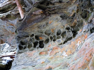
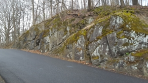
Many of the most powerful currents abut the stream bank. Where this occurs muddy gravels collapse into the flow and this sediment is rushed away. Beneath the white surface, the water is brown with erosion. It’s this scouring that has carved the great notch in the mountain.

On a quiet summer or autumn day Stony Clove can be a site of serene natural beauty, a quiet place to picnic or just sit and gaze. But the serenity is deceptive; there is real violence in the clove’s origins. You can’t really understand Stony Clove unless you understand its past. You have to use your mind’s eye and you need to know its geology to do that. This is the science of it all.

Contact the authors at randjtitus@prodigy.net. Join their facebook page “The Catskill Geologist.”

Tafoni: a geologic mystery March 22, 2018

in Uncategorized by

Tafoni: A real mystery, and a local one at that

On the rocks

May 29, 2014

Updated by Robert & Johanna Titus


Phoenicia has been in the news a lot over the years. It is best known as a place that has had serious flooding problems. Various northeasters, along with the occasional hurricane, are enough to fill Stony Clove Creek to overflowing. The creek swells up over its banks and makes a mess of the town. Engineering efforts to improve flow beneath the bridge there have been controversial. Their effectiveness is questioned.

But, that’s not the topic of this column.

We were recently invited to go to Phoenicia and take a look at some very strange geological phenomena. Our host was Paul Misko, of the Catskill 4000 hiking club. As a veteran hiker, Paul can be found just about anywhere in the Catskills and he has a real eye for unusual geology, so we paid attention to his “very strange” claim. He had piqued our curiosity and, when we got there, we weren’t disappointed; we found a real puzzle. Across the street from the St. Francis DeSales Roman Catholic Church, is a small park. If you walk into the park from Main Street and bear toward the right (east), you will soon find a small hiking trail. It’s called the Tanbark Trail (you can run a search and get a map of it). Climb up a steep incline, and towards the top you will find a fairly sizable ledge of sandstone. It’s rather commonplace stuff; it is a very typical Catskills bluestone ledge. We recognized what are called cross beds. That is to say that a lot of the strata here dip in one direction or another. They were not very well defined, but they were there. That is normally the case with bluestone that was deposited in river channel sandstones. This ledge is, in essence, the cross section of a very old stream. It’s, like all rocks in the Catskills, Devonian in age, something a bit less than 400 million years old.

None of this surprised us in the least. It was strictly routine stuff. But that’s where we encountered that mystery. Take a look at our photo and see what you think. The first view shows the entire ledge. Commonplace cross-bedded bluestone makes up the whole lower half of the exposure. Up top are a large number of closely spaced and very strange cavities. The close-up view shows a tightly packed cluster of these cavities in the rock. Their shapes vary considerably, but they all show a sort of boxy nature and they seem to form an interlocking network. We would like to use the term honeycomb here, but honeycombs show a consistent hexagonal shape; we don’t see that with these. The rock remaining in between these cavities is narrow. The cavities do not penetrate too far into the rock, just a few inches. And there is no reason to think that there is another horizon of these cavities under the ones that are visible. Thus, they appear to be surficial features. Nevertheless, these cavities seem to be concentrated. Many of these cavities are spaced so close together that they comprise a bigger compound cavity. Whatever it was that formed them was focused.

All in all, this is the most puzzling phenomenon that we have seen in ages. There is no trouble putting a name on what is here; it is called tafoni. Each individual cavity is a tafone; lots of them are tafoni. And the terminology keeps getting better; when tafoni occur on cliff faces, as at Phoenicia, then it is called lateral or sidewall tafoni. But, putting a name on something is not the same as understanding it.

What are these features? They seem to be weathering phenomena. Somehow, they appear on the rock surface and grow slowly into their observed shapes, but exactly how? And, also, how is it that they grow in size until they abut each other but do not grow into each other? How do they grow in size without intersecting? Those are very puzzling questions and just naming these things does not provide answers.

Tafoni have been weakly associated with poorly defined stratification on the sides of cliffs and that is the case here. But that still leaves a lot unsaid. Why does this “association” occur? What are the specifics? Salt is commonly cited as an agent in Tafoni development. They are sometimes found on coastal outcroppings, splashed by ocean waves. But there is certainly no source of salt here on a sandstone cliff in Phoenicia. And that begs the question: what exactly is different about his cliff? We have literally seen hundreds of similar cliffs, all through the Catskills and all composed of the same type of sandstone, all originally deposited in the same Catskills Delta river channels. Why don’t all of those other cliffs have tafoni? Why isn’t it that none of them do? There must be something here, right in front of us, which we have missed. This is the sort of thing that makes science so much fun.

Do you have any ideas or questions? Have you seen tafoni somewhere? Contact the authors at randjtitus@prodigy.net. Join their facebook page “The Catskill Geologist.”

The Gilboa Forest March 15, 2018

in Uncategorized by

Buried alive, the Gilboa Forest

On The Rocks

The Woodstock Times

Oct 10, 1996

Revised by Robert and Johanna Titus

It’s autumn and once again the leaves are in color. This annual event has not always been. Autumn color is a characteristic of today’s advanced deciduous trees, but there was a time when the world’s forests were composed only of the most primitive plants. In fact, there was a time when there were no forests at all. We New York State paleontologists get to see the transition from a world without forests to one with them. We have very old terrestrial deposits here, red sandstones of Silurian age. They formed in habitats where trees should have been common but they have no fossil trees at all. Then there are the Devonian age Catskill red sandstones. They are only about 40 million years younger, but they have a great abundance of fossil trees. During that interval trees evolved and spread out across the Earth as the first and oldest forests.

Fossil trees this old are extremely rare, but you can go see some of them yourself, and enjoy a fine autumn drive at the same time. From Woodstock take Rte. 28 to Rte.42 and drive from from Shandaken to Lexington. Then take Rte. 23A west until you reach Grand Gorge. Take Rt. 30 north 2.8 miles and turn right onto Rte. 990V. Go downhill another 1.2 miles and you will reach Schoharie Creek where it passes through the village of Gilboa. Just beyond the bridge is a little park with some very fine fossil tree trunks. This humble site commemorates one of the world’s most famous fossil locations, the Gilboa forest. After looking at these fossils you can proceed a short distance to the Gilboa Museum. It’s only open on summer weekends but it displays some more very fine fossil trees.

The Gilboa forest was discovered after the terrible Schoharie Creek floods of late 1869. Extensive erosion along the river ripped through soft red shales and exposed a number of fossil tree stumps. The discovery caused quite a stir and well it should have. This was the oldest known fossil forest; before them nobody had ever guessed that trees were this ancient.

It got better in the 1920’s. Excavations for the Schoharie Reservoir revealed about 200 more fossil stumps. The trees in the little park were among these. These famous Gilboa fossils offer us a rare view of what forest ecology was like very early in its history. Gilboa was forest of trees, most of them called progymnosperms. In common terms that means that these were essentially very big ferns with tall wood stems (trunks). In time they would evolve into today’s common cone-bearing trees, called gymnosperms.

Beneath the trees was simple ecology of even more primitive plants. Hiding among them was an animal ecology of simple arthropods. These were an abundance of centipedes, millipedes, and simple insects, along with many truly exotic creatures. One of note is that Gilboa is the home of some of the oldest known fossil spiders. This is certainly a peculiar, but truly remarkable distinction for a small town. Spiders are among the most abundant and successful groups of invertebrates on the planet and some very old ones are right here!

There are ironies in the story of Gilboa. The trees are a metaphor for the great cycles of time. They grew not along the Schoharie Creek, but along some ancient nameless stream of the old Catskill Delta. They were long ago buried in the muds of a long forgotten flood. There must be a story here: What kind of flood was this? How bad was it? There is no answering such questions. For hundreds of millions of years they lay entombed in those flood sediments. During that time they hardened into rock. If it was floodwaters which buried them, then it would be flood waters which would release them. These trees of stone lay in wait for the day when another awful flood would bring them back into the light. The irony came when so many of them were once again submerged in the waters of the Schoharie Reservoir.

Contact the authors at randjtitus@prodigy.net. Join their facebook page “The Catskill Geologist.”


Ordovician earthquakes 3-7-18

in Uncategorized by

Cycles of earthquakes?

Windows Through Time

Robert and Johanna Titus

April 14, 2016


A fun part of our job with the Columbia-Greene Newspaper chain is just going out and exploring for some fascinating locations where there is good geology. Recently we were in Saugerties to hear a lecture at the Friends of Saugerties History Group at the town library. Afterwards, we just went exploring. We found ourselves heading south on Partition Street, we crossed the bridge over Esopus Creek, and took the first left onto East Bridge Street. That took us along the Esopus on Ferry Street.

We didn’t expect to see much. You see Esopus Creek, long ago, when it began flowing into the Hudson, formed a pair of peninsulas that pushed out into the larger river. We expected that these would be composed mostly of sand and would be pretty boring stuff. Well, we were wrong.

A little less than a quarter mile down the road we were forced up and over a sizable knob of rock. When they constructed Ferry Street they had to blast through all that rock. And that gave us a beautiful exposure of bedrock.


We recognized the rock unit, immediately. It was the Normanskill Formation. That has some very important and very interesting geology. It dates back about 450 million years and it is big. Much of the middle Hudson Valley is blanketed with the Normanskill. A lot of it is west of the river, but there is more of it on the east side. It’s named after Normanskill Creek where a very large exposure is found. That‘s where Rte. 9W approaches Rte. 787.

It’s a unit that we should be writing about more often. It is composed of a mixture of thick dark gray sandstones and thinly laminated black shales. Way back during the Ordovician that sandstone was sand and the shale was mud. These sediments accumulated at the bottom of what is sometimes called marine trench or an “oceanic deep.” Deep indeed; that’s a stretch of ocean that can be 20,000 feet deep or more. The best known modern deep is the Marianas Trench in the western Pacific. It is more than 35,000 feet deep! Well, you can easily imagine those rocks caught our attention. They took us down to the deepest parts of the sea—to the very abyss.

But there is more—a lot more. Those black shales speak to us of routine moments on the floor of such deeps. They accumulated one lamination at a time. Silt and clay slowly settled to the floor of the ocean. It takes grains of silt and clay months, even years, to sink that far. So these sediments accumulated very slowly. A few inches of this sort of black shale may represent enormous amounts of time. How much time does a foot of shale represent? Well, in truth, we geologists have no idea, but it is a lot of time.

Not so with those sandstones. They are different. They are a special type of sandstone; they are called greywackes. A greywacke is not just a sandstone; it is a “dirty” sandstone. You are probably used to the clean white sands that we see along the Atlantic coast; those are almost pure quartz sands and quartz is almost white.
But these greywackes are different; there is a lot of quartz in them but they also have a large amounts of silt and clay. That’s the dirt in a “dirty” sandstone.

Greywackes are remarkable for how they form. They are often the products of submarine avalanches. Typically an earthquake strikes the deep sea floor and masses of sediment are thrown up into suspension. Such masses of sediment then, slowly at first, begin to flow down the slopes of the deep. Those avalanches are called turbidity currents and they quickly pick up speed. Soon they are thundering down the steep slopes into the abyss. Eventually they reach the bottom and begin to slow down. When they slow down enough, all that dirty sand slows to a halt and deposition occurs. Hence the greywackes we saw—and probably each one of them.

All this gets us back to the Ferry Street outcrop. It has an eye-catching feature; there are six thick horizons of greywacke and, in between them, are those expected black shales. But the shales are thin, only inches thick. That conjures up quite an image.

We walked along this outcrop and counted those six thick greywackes; we realized that we were likely counting earthquakes. And those thin shales indicated to us that those earthquakes and those turbidity currents had come in relatively short intervals. Those earthquakes were occurring in the nearby rising mountains of New England. Those mountains were in full uplift mode and we saw the results—in Saugerties.

Contact the authors at randjtitus@prodigy.net. Join their facebook page “The Catskill Geologist.”


Bugs in the house 3-1-18

in Uncategorized by

Bugs in the house

Windows Through Time

Columbia Greene Media

Sept. 23, 2010

Updated by Robert and Johanna Titus


We don’t know how it is where you are, but in Freehold we have had one amazing summer for centipedes. They are all over the place! We find lots of them on the undersides of logs we have been using for firewood. We have also seen them scurrying around all over our property. Unfortunately that includes even inside our house where the little creatures have been making some occasional appearances. One of us, Johanna the biologist, has been controlling her professional enthusiasm very well! We wonder what causes such a biological event.

Centipedes are a large group of creepy crawlers. The word centipede roughly means hundred legs. When we were kids we spoke of “thousand leggers” and “hundred leggers.” Millipedes were the former; centipedes were the latter.  They both belong to an extremely large group of animals called the phylum arthropoda. Arthropods also include insects, crustaceans, and spiders. The centipedes are common members.

So, why are centipedes the topic of a geology column? The answer is that they are part of our Catskills geological history. We have written about our Devonian past in this column a number of times. About 375 million years ago a great delta spread out across that which would become New York State and, growing upon it, was something called the Gilboa Forest. That was a great expanse of tropical jungle. Our Catskills are essentially a petrified delta and these mountains possess the fossil remains of the plants and animals that lived on it. This is the oldest well preserved fossil forest ecology known to science so it is important. Paleontologists long ago learned a great deal about the plants of this jungle, but there were real limits on how much we knew about the animals that had lived in this ecology. There should have been a lot of animals living in the Gilboa Forest but they, for the most part, refused to be found.

Then, a quarter century ago, geologists at SUNY Binghamton found a way to dissolve Catskill sandstone so that the rock disappeared and the remains of tiny creatures that had been in them were separated out.  Hydrofluoric acid does a good job of dissolving the silica of rock, but it leaves the cuticle of arthropods alone. Using this technique, those Binghamton paleontologists quickly discovered bits and pieces of the skeletons of numerous arthropods, including quite a few centipedes. This was important research. Now geologists could start to put together lists of the animals that had inhabited this ancient forest. We were getting our first look at early forest ecology.

That list proved to be pretty much what people had expected. Our Devonian forest was populated by relatively primitive animals, and most of them were arthropods. There were very primitive insects and then a fair number of creatures which would be familiar to you: mostly spiders, millipedes and centipedes.

The point we are driving at is that those centipedes, which have been plaguing us this summer, have been around here for a very long time. And they have evolved, but not so much that you would notice it. We like to say that these creatures are “ambassadors from the Devonian.” When we look at them, we feel that we are looking into the past. If we were ever lucky enough to find a fossil centipede we would be thrilled beyond imagining. But, there they are – not fossils made of rock, but real living, breathing centipedes. To people like us this is a bit of a thrill.

Modern centipedes have to live in moist surface layers of soil because their skeletons lack a waxy coating which would keep water inside them. They have always been like this and, back in the Devonian, they inhabited the duff, or the moist humus-rich surface soils. They all have mean looking pincers, located at the most forward portion of their bodies. These pincers are not just mean looking; they are venomous too. These are used to kill and these little creatures are carnivores. They are the saber tooth tigers of the soils. Nobody is exactly sure what they eat as they are only active at night, but small worms are likely candidates for their meals. The largest fossils of these killers were over three feet long, a very frightening notion. We are not sure if any of our local centipedes are powerful enough to penetrate human skin, but we have made no effort to test that hypothesis, and we hope that you won’t either. Some have been reported to harm humans with their bites, especially small children, so we wouldn’t temp fate with any you see. But do take a good look, maybe with a magnifying glass. You are looking into the Devonian. Contact the authors at randjtitus@prodigy.com. Join their facebook page “The Catskill Geologist.” Read their blogs at “thecatskillgeologist.com.”


Go to Top