"I will never kick a rock"

Monthly archive

February 2018

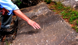
The Schenectady landslide Feb. 22, 2018

in Uncategorized by

The Schenectady landslide.

The Catskill Geologists

The Mountain Eagle

Feb. 2, 2018

Robert and Johanna Titus


Have you heard about the recent landslide in Schenectady? A mass of mud slid down a steep hill along Nott Terrace road and did major damage to two houses. It injured at least one person and left perhaps two dozen others looking for a home. This is the type of story that we have been covering for more than ten years now. Landslides are frequent geological hazards up and down the Hudson Valley and throughout parts of the Catskills. We think that this threat should be better known by you, the public.

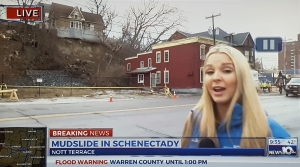
Albany, Channel ten covers the story. Landslide behind red house


We need to give you a little background first. Back in the later stages of the Ice Age, much of the Hudson Valley was submerged in a body of water called Glacial Lake Albany. That included all of the land that is now Schenectady and Rotterdam. The Mohawk River was a powerful flow back then, carrying large amounts of water from melting glaciers. It flowed into Lake Albany and carried huge amounts of sediment, which were deposited into what became a very sizable delta. Those deposits were mostly sand, silt and clay; when wet enough they become mud.

The lake eventually drained and the delta was left behind, literally high and dry. It provided ideal conditions for people to settle. Delta tops are flat and easy to develop. It was simple to lay out roads. Settlers could build homes with deep, well-drained basements. Those homes were high enough above the Mohawk River so they did not have to fear flooding. It’s a remarkable thing to realize that both Schenectady and Rotterdam are where they are because of the Ice Age.

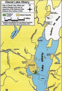
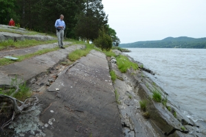
Schenectady lies on the delta.

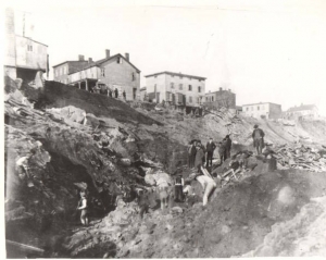
Over the millennia, rivers cut canyons into the delta and there lies the problem. Those canyons often have steep slopes and, when the delta deposits become wet from rainfall, they turn into mud and that mud can let go and slide downhill as mudslides. That happens from time to time. One of the most recent such events occurred in the spring of 2004. Heavy rain, the previous autumn, had soaked the ground at 1st Avenue in Western Schenectady. The Mohawk River and an unnamed creek had eroded into the delta deposits there and created a steep slope, 80 or 90 ft. tall. When the slide began, it caused six houses to slowly subside. It is our recollection that they were all condemned. In January of 1996 a similar event occurred on Broadway, near Rte. 890 where Pleasant Valley Creek created a similar steep slope. That landslide, occurring after heavy rains, killed one man. The Nott Terrace slide is an event very similar to these.

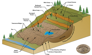
As geo-journalists, we have been following this story for years. We have seen similar events in Delmar, Greenport, Rennselaer, Germantown and just a few years ago in New Baltimore. We fear that many more such slides will occur throughout the Hudson Valley, including at historic sites in Hyde Park. All of these slides involved the sediments of Lake Albany. These silty lake sediments soak up a lot of rainwater. When they reach a certain point, they become unstable. Great curved fractures open up and masses of earth slide along the curves of what are called rotational slumps.

All this is important; it is our region’s greatest geo-hazard. This will happen again.

Reach the authors at randjtitus@prodigy.net. Join their facebook page “The Catskill Geologist.” Read their blogs at “thecatskillgeologist.com.” Watch for their columns in Kaatskill Life and Upstate Life magazines. They are frequently in the Woodstock times.


Bard Rock Part two Feb 16, 2018

in Uncategorized by

Bard Rock in the Ice Age

Windows Through Time

Columbia Greene Media

July 4, 2013

Updated by Robert and Johanna Titus


Last week we visited Bard Rock. That’s a large outcropping of sandstone and shale located at the northern end of the Vanderbilt National Historic Site in Hyde Park. The National Park Service operates a number of hiking trails there and you can take one to the Bard Rock site. The rocks here rise to a gentle peak and trees have grown in where soils formed between the rock exposures. It’s a nice location, ideal for picnicking – and for looking at geology.


The two of us were down there filming videos about the geology of the whole Vanderbilt estate and we wanted to include Bard Rock. Last week we wrote about the history recorded in the bedrock. Those sandstones and shales formed in the depths of a very great marine abyss. This week let’s see if we can figure out the ice age history of the same location.

Take a good look at the photo here. You will see horizons of sandstone and shale. The hand is pointing at a fine thick stratum of sandstone while the foot is on a horizon of shale and grass is growing on another shale. The hand is purposely hovering over evidence of the ice age. Notice how polished the sandstone is; that surface, although sloping, is really quite smooth. What happened is that the Hudson Valley glacier, many thousands of years ago, advanced across this outcrop. The glacier carried large amounts of sand, concentrated at its bottom, and that sand did what sand is good at: pressed by all the weight of a very heavy glacier, the sand ground into the bedrock and – sanded it. It smoothed it off into the surface you can see there today. If you visit this site and step back a bit, you can see that this surface extends up and down the outcrop. Or you can look at the photo we published here last week.

You rise up from the outcrop and gaze across the whole Hudson Valley. In your mind’s eye you fill that valley with ice. There is quite a bit of it. It is hundreds and, more likely several thousands of feet thick. We have gone back in time and visited this site at the peak of the Ice Age, changes your perspective on things, doesn’t it?

But there is more. Take another good look at the illustration. Notice that the hand hovers over some scratches in that glaciated surface. These are called glacial striations. The Hudson Valley glacier didn’t just carry sand; it swept along a large number of pieces of gravel and cobbles as well. Every time one of these bits and pieces of rock was dragged across this surface it left a scratch. Most of them have north-to-south compass orientations. That can’t be much of a surprise. Not only do most glaciers travel in a southward direction but the Hudson Valley glacier was confined and funneled within its north-to-south oriented valley.

But there are some exceptions to that rule. A few of those striations trend from the upper right to the lower left. That sounds like it should not be, but there are explanations. Very late in an ice age, it is not uncommon to have one final advance of the ice. That last-gasp glacial advance is likely to be very small and so it is not pushed so much from the north as it is steered by some unknown local feature. Typically glaciated surfaces are like this one; they have a lot of north-to-south striations and a few local exceptions. Those exceptions dress up the exposure and speak of minor events at the very end of the glaciation.

There is nothing all that rare or unusual about this exposure of ice age features. There are a lot of similar sites all up and down the Hudson Valley. In fact there are a lot of such sites all across the northern half of North America. Wherever the glaciers traveled they left features and exposures just like this one. These are among the most widely seen evidences of the Ice Age. They are the sort of thing that all geologists are accustomed to look for and to see. Though common, we never get tired of finding things like this. We like to bring compasses along and measure the compass directions of similar striations. We plot arrows up on maps and thus document the pathways of once advancing ice. What’s special about these striations is the scenic site where they are found and which they helped form.

Contact the authors at randjtitus@prodigy.net. Join their facebook page “The Catskill Geologist.” The Vanderbilt videos are currently posted there,

Bard Rock – Part One Feb. 28, 2018

in Uncategorized by

Bard Rock – 450 million years ago

Windows Through Time

Columbia Greene Media

June 27, 2013

Updated by Robert AND Johanna Titus


The two of us have been doing some work for the National Park Service down at Hyde Park. We have shot several videos in which we describe the geology of park lands down there. They have posted this on their website. All this included a visit to Bard Rock and we found an interesting story there, actually two interesting stories. Let’s do one this week and save the other for next week.

Bard Rock is just what it sounds like; it is a sizable outcropping of bedrock. It’s located at the northern end of the Vanderbilt Mansion National Historic Site. That’s the old Vanderbilt estate. It is positioned right on the shores of the Hudson River and that helps make it a very scenic location. You will have to do some walking to visit it; it is on the Bard Rock Hiking trail, part of the park’s system of trails. It’s worth the effort as it really is a pretty location.

But it has a lot of good geology too and that’s why we filmed there. We did a little research before going down and that included looking at the local geological maps. We found, as we expected, that the local bedrock belonged to something called the Normanskill Formation. If you want to be technical, the local rocks belong to the Austin Glen Member of the Normanskill Formation. The two of us are quite familiar with the Normanskill, as we have frequently visited outcrops of this unit. It is one of the most widespread rock units in the Hudson Valley.

The Normanskill is a mix of alternating horizons of dark gray sandstone and black shale. When we got to this outcrop we found it to be a very typical one. There were many nice thick sandstones and an equal number of thinner horizons of black shale. The shales are the indents on our photo. They set up the video camera and we went to work hamming it up, Robert clambered up the outcrop’s slope and with each step said things about “sandstone – shale – sandstone.” Then he got serious and started an explanation of what he was seeing and experiencing here.

The Normanskill Formation is Late Ordovician in age. It takes us back a full 450 million years. That’s a long time ago, and you can understand how we geologists expect that things were different back then. Today these rocks lie on the edge of the Hudson River; back then it was very different. There was no Hudson River during the Ordovician and there were no hills such as we see hereabouts today. The sandstones and shales were here but not as hardened rocks. They were soft sands and very soft muds.

It all gets even more unfamiliar, the more you think about it. We were at the bottom of a very deep ocean. This might be called the Normanskill Basin, but we think it would be better to call it the Normanskill Trench. If you know your way around the Pacific’s geography you will know that there are a number of extremely deep places. Long linear trenches exist and they can be 20 to more than 30 thousand feet deep. The best known, and deepest, is the Marianas Trench, located in the western Pacific adjacent to the Marianas Islands. Trenches form when two great crustal plates collide with each other. They are “creases” between the two plates.

But if you are not familiar with plate tectonics then let’s keep it simple and just say that it was a very deep ocean that accumulated the sediments and sedimentary rocks of Bard Rock. Robert stood up and looked at the camera and then turned a full 360 degrees. He described being on the bottom of this Normanskill Trench. All around him the water was totally black, completely still, silent and very cold. This seemed a lifeless seafloor; almost nothing lived here. Beneath were sticky soft muds. Both of us were “experiencing” the origins of those black shales.

But now he had to explain the thick gray sandstones. He described the striking of an earthquake in some nearby region. The seafloor shook violently all around. Soon masses of sediment, high above in shallower waters, rose up as clouds of sediment. They were, slowly, pulled downslope. Then they picked up speed and became a massive submarine avalanche. For a very unhappy period of time, masses of dirty water passed by. Then things slowed down and settled to a halt. Robert looked around and saw several feet of sand, all deposited by that terrible event.

And then, in a flash, he was back at the edge of the Hudson River on a beautiful late spring day. Geologists live such interesting lives.

Contact the authors at randjtitus@prodigy.net. Join their facebook page “The Catskill Geologist.” The Vanderbilt videos are currently posted there.

The Haverstraw Landslide – Feb. 1, 2018

in Uncategorized by

Landslides at Haverstraw

Windows Through Time

Columbia Green Media

Aug. 6, 2015

Updated by Robert and Johanna Titus


We continue our series on the landslide threats of the Hudson Valley. Today we head south quite some distance. We arrive at Haverstraw, a town that lies only about 15 miles north of New York City.  Throughout our series we have emphasized that most of the landslides that we see in our region are natural in origin. Usually heavy rains soak into the soft silty clays of something called Glacial Lake Albany. Water pressure, within those sediments, builds up and those deposits become unstable. The clay gives these sediments a brittle component and concave curved fractures open up. Masses of lake sediments rotate downwards, sliding along these fractures and the landslide results. Quite often, a steep slope, cut by the erosion of some nearby river, contributes a great deal to the hazard.

Diagram of a rotational slump

Are these always natural events, or can man play a role? That’s an important question.  There are few, if any, things that we can do to head off natural landslides but, where man is involved, then that is different. At the April 2025 Normans Kill landslide in New Baltimore there is a chance that man’s efforts played a role.  A sizable amount of earth had apparently been dumped at the top of the slope that, soon thereafter, slid. The two of us disagree on whether this led to the slide, but let’s explore the issue in Haverstraw.

Our trip takes us to a location where a terrible landslide once occurred. And, it is among the most undisputed locations where man’s intervention allowed nature to produce a landslide. Haverstraw is located atop a thick sequence of the sediments of Glacial Lake Albany, lying along about three miles of the Hudson’s banks. Lake Albany did extend this far south and more.  A little after the end of the Civil War there was a growing need for bricks to build fire-resistant buildings in New York City. The lake deposits of Haverstraw had been deposited well offshore within Lake Albany and, as a result, they were unusually rich in clay. That made for very good bricks. Not surprisingly, a very substantial brick industry appeared in Haverstraw. As many as 350 million bricks per year were manufactured in dozens of local brickyards. This industry would thrive well into the 20th Century.

This was not a time when there were many refined environmental attitudes. Nor was it a time when there were many carefully thought out strategies to avoid what are sometime called “geo-hazards.” The sprawling brick industry here was sowing the

seeds of its own destruction. The banks of the Hudson had been tall and steep long before the brickyards arrived. Steep slopes, of course, favor landslides. It got worse. To

Haverstraw after the landslide

mine the clays people dug into the deposits and created even taller and steeper, and more dangerous, slopes.

Then it got still worse. The downtown section of Haverstraw, along with the brick yards, came to be developed right up against the land excavated for clay. Take a look at our photo, taken just after the landslide, and see how precipitous the slopes were. Then things got completely out of hand. Tunnels were cut under the downtown area, and the brick yards. They were actually mining clay! This foolishness only made an already unstable landscape even worse.

Our journey takes us back to the winter of 1905 and 1906. Early on, it had been a harsh, cold and snowy winter, but then there were heavy rains. It must have warmed up and the rain is likely to have fallen onto the snows, melting them.  You see the problem; great volumes of water had to have been soaking into the ground, making it more and more unstable. And below those increasingly unstable grounds there were tunnels.  A disaster was about to occur!

This brings us to the night of Jan 7th and 8th, 1906. The collapse began in the middle of the night. A full six square city blocks sank into an expanding pit. There were electricity and gas lines in Haverstraw at that time, and they made things worse. The gas lines broke and sparks set the leaking gas ablaze. Most of the town burned. One pauses and thinks of the San Francisco earthquake and fire which also occurred in 1906.

A modern geologist reads the accounts of this awful event and wants to scream. They broke all the rules in Haverstraw. They cut steep slopes into the glacial clays; we call this over-steepening. The tunnels only made it worse, and we just cannot imagine such a thing being allowed nowadays. Then they brought development of the town and the brick yards so close to that steep slope. We shake our heads in disbelief.

Contact the authors at randjtitus@prodigy.net. Join their facebook page “The Catskill Geologist”

Go to Top