Christmas Rocks Dec. 14, 2023
Christmas rocks? in January?
The Catskill Geologists
Robert and Johanna Titus
Jan. 25, 2019
Have you joined our facebook page yet? We have been running it for several years now. It’s called, logically enough, “The Catskill Geologist.” We post notices of all our newest articles in it. Also, when Robert has a working memory, we post schedules of our upcoming speaking events, hikes and whatever else is keeping us busy. The page gives you a chance to be more engaged with what all we are up to. We have nearly three thousand members, so we hope you will join too. Soon.
All our members are able to actively participate in our facebook page and many do. We have had any number of people post pictures of geological phenomena that they have found. Often, they really do not know what it is that they are posting, but we can typically identify it or find someone who can. If all this sounds like something you would enjoy, then do join us.
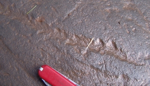
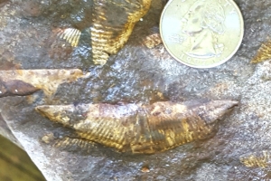
Recently a member sent in a photo of a rock that he found in the upper Esopus Creek Valley. It was one of those catches-our-attention kinds of rocks. Take a look at his photo. You will quickly see what interested him. It’s a Christmas sort of rock, isn’t it? See the bright red color mixed with the green. Well, we recognized it right away. This sort of rock is referred to as being “mottled.” That’s a rock that displays a mixture of colors. They aren’t always reds and greens, but this one is so let’s talk about it.
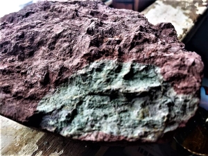
But, first things first. We always like to say that the hardest thing to see in science is something that is not there. That’s the case here. This rock came from the Catskills, so it should be a stratified sedimentary rock; that is, it should be layered. But it is not stratified and that will turn out to be important.
The colors are the most important things. The red is typical of soils that form in tropical or subtropical settings. Have you ever heard of Georgia red clays? They are red soils found in Georgia. They formed during the last big interglacial time when the climate down there was a lot warmer and more humid than it is today. This sort of soil can be thus be called a tropical soil. Such soils today, commonly form within rain forests. There is always a lot of iron in any soil and the red color means that it is oxidized; it combined with oxygen. That occurs most often in the upper soil horizons where a good amount of air (with oxygen) is likely to be found.
So, what does the green mean? Green colors in this sort of soil occur farther down where it is likely to have been soaked in groundwater. That’s below the water table. Here there is much less oxygen for the iron to combine with and we say that the soil in not oxidized but reduced. Well our facebook member has found a rock that formed near the top of the water table where both oxidized and reduced soils can be found.
In either event we are looking at a soil forming processes, so this is a petrified soil, although not an especially good one. Soils are not typically stratified so that is consistent with what we have seen. It takes us back to the middle Devonian time period, about 380 million years ago, when the Catskills were not mountains, but a great tropical delta with red soils forming on it.
———————————————————————————————————————
Contact the authors at randjtitus@prodigy.net. Read their blogs at “thecatskillgeologist.com” And please do join their facebook page “The Catskill Geologist.”