"I will never kick a rock"

Author

Robert Titus - page 2

Robert Titus has 434 articles published.

A Plowed Field – Aug. 29, 2024.

in Uncategorized by

Geology of a plowed field?

The Catskill Geologists; The Mountain Eagle – Oct. 25, 2018

Robert and Johanna Titus


We are not farmers, so we don’t know why farmers plow their fields at this time of the year. But, as geologists, we do know what to look for when they do. In fact, it is not unusual for us to slow down and take a good look at a newly plowed field; Whatever are we looking for? Well, not surprisingly, we are exercising our trained eyes. And today, we would like to help you do the same.

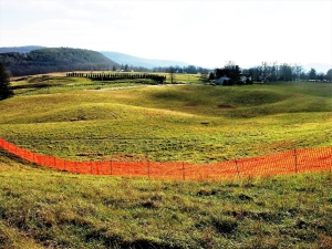
Recently we were driving south, down Rte. 9G toward Hyde Park, when we saw the freshly plowed field in our first photo. Take a look; what do you see? Or, rather, what do you not see? We always like to say “the hardest thing to see in science is that which is not there. Take another look at our photo: what is not there? You are probably going to kick yourself when you miss this.

The answer is that there are no rocks lying on the ground. Isn’t that just a little strange? What happened the last time you did some digging? You probably hit “two rocks for every dirt,” right? So, what happened to those two rocks? Actually, they were never there. It turns out we had been driving along an old glacial lake. Lake deposits are almost all silt and clay. There are no rocks. That glacial lake has a name; it was Glacial Lake Albany and, back at the end of the Ice Age, it flooded much of the Hudson Valley, including our location along Rte. 9G. Its waters are long gone; they drained away. But the old silts and clays are all still there. One way to identify them is to wait for plowing and watch for that absence of cobbles. We like to pull over, get out and, in our mind’s eyes, gaze at the lake that we and perhaps only we, can envision.

Let’s take you to another location along the highway, Rte. 9, just south of Rhinebeck. Now your newly trained eyes probably won’t have much trouble in seeing what is there: rocks, and lots of them. What happened here? Why is this so different? This is another wide flat landscape, and you might be tempted to interpret it as another old lake bottom. But, don’t forget all those silts and clays of lake bottoms. This flat surface is quite likely a floodplain. Flood plains often are stony like this one. Floodplain deposits are generally deposited by flowing river waters. There are a lot more floodplains on his planet than glacial lakes so there is no surprise here.

So, why are we talking about sediments east of the Hudson; that’s pretty far away. Well. don’t forget we are here to train your eyes. We would like it very much if you began paying attention to flat landscapes, especially when they are plowed fields. There will be a lot of them come next spring, and that likely includes places around where you live.

Contact the authors at randjtitus@prodigy.net.  Join their facebook page “The Catskill Geologist.”

Welcome to the Anthropocene; Aug. 22, 2024

in Uncategorized by

Ecology in the Anthropocene

Robert and Johanna Titus; The Catskill Geologists; The Mountain Eagle

Sep. 19, 2019


The frontiers of science are always exciting places to be. There can be so much creativity going on, sometimes even a frenzy of fast paced deep thinking. Our field, geology, is a very old and a very mature science so you might think that little of this occurs anymore. Maybe, maybe not.

In recent times our science has been debating something called the “Anthropocene.” That’s a, so far, hypothetical unit of time that may have only recently begun. The question is “has mankind altered the world so much that the fossil and stratigraphic record will record and recall the impact of this alteration?” Will geologists of the distant future find stratified rocks that record dramatic and worldwide changes that date back to our times? Late at night in geology bars we, today’s geologists, debate all this.

Well, the two of us think that this notion of an Anthropocene just might be legit. We think that there are two trends going on currently that will dramatically alter the future fossil record. First, there seem to be reasons to foresee a general decline in worldwide biodiversity. That’s because of, more than anything else, habitat reduction. Our human species numbers about 7 1/2 billion individuals today and that will quite possibly continue increasing until leveling off at about 11 billion by the end of this century. There were only two billion of us as late as 1930 so you can see that a dramatic population growth has been underway.

Along the way we have also been expanding into habitats where we had been, not long ago, few in numbers. Currently our accelerating expansion into the Amazon Basin is the most striking example of this. All this has led to worldwide habitat reduction which has been literally squeezing out one species after another. We have, for example, real fears for the near future fate of the Amazon Basin. The rapid reduction of elephants is also another cause for concern. We can only guess that the future fossil record will see a depletion of species diversity, recorded in the stratified rocks of our age. That would mark the beginning of the Anthropocene’s new and very different fossil record.

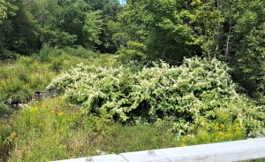
  Japanese knot weed

But there is something else. Our expansion throughout the world has facilitated the appearance of abundant invasive species. Where we live, in Greene County, there has been an increasing abundance of Japanese knot weed. Throughout the American South there are massive infestations of kudzu. Both are invasives that were transported from Japan with the help of human intervention. Among other things, invasives have the potential of reducing or eliminating native species. The invasive chestnut blight fungus has, for example, all but eliminated the chestnut. Our images of the Anthropocene ecologies are thus not just depleted in species but far more homogenous as well. Future geologists will likely see depleted and homogenized Anthropocene fossil records. That will help define the new time unit.

We want to make a few more points. First, none of this has anything to do with global climate change. If we could push a button and carbon dioxide emissions would come to a complete halt, that might stabilize the climate, but it would hardly stop or even slow human population growth. So too, it would not end habitat reduction. Nor would it even slow species invasions. Second, we do not recall seeing a lot of discussion of these issues. We suspect they have been overshadowed by talk of climate change. These are altogether different ecological problems. That’s troubling.

Are these changes enough to define a new epoch of geologic time? Others think the appearance of radioactive wastes is important. And how does human driven climate change fit into this scenario? Late at night in geology bars…

Contact the authors at randjtitus@prodigy.net. Join their facebook age “The Catskill Geologist.”

Cabin Rock in Windham Aug. 15, 2024

in Uncategorized by


“Cabin Rock” in Windham; Robert and Johanna Titus

The Catskill Geologists; The Mountain eagle; Aug. 23, 2019


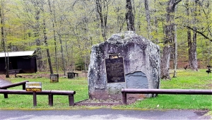
Have you been reading us in Kaatskill Life magazine? This current issue, Summer 2019, has an article by us that includes a visit to Windham. We went there while researching an article about large boulders that are called “standing stones.” Standing stones are great flat boulders that should, of course, be lying flat on their sides. They aren’t. Instead, standing stones are, as the name implies, standing upright. We were told that there was a good one in Windham, so we went to see for ourselves. And there it was, just west of the Windham Fire Department. It has a name; it’s called Cabin Rock.

But standing stones seem so unlikely; how could such things be? Well, one obvious explanation is that they were hoisted into place by people, perhaps people of a prehistoric stone culture. These things do exist, but mostly in Europe and Asia. Such standing stones are suggested to have served religious or astronomical purposes. This would make our local examples the Stonehenge stones of the Catskills and that would be pretty exciting. Who wouldn’t want this to be true?

Well, as scientists, we are always skeptical of such claims. The late astronomer Carl Sagan said it so well: “Extraordinary claims require extraordinary evidence.” It’s one thing to conjure up an ancient stone age culture but is another to back that claim up with evidence. Suppose any of these standing stones had actually been of cultural significance? That extraordinary claim should be, we think, easily supported by conventional archeology. A society that valued such stones should have left behind the flotsam and jetsam of their culture: flints, pottery shards or whatever. But, in America, such archeology is hardly, if ever, found with standing stones. These extraordinary claims are not even backed up ordinary evidences.

So, are we skeptics right? Well, not yet; there is still a real problem here. It is, after all, an equally extraordinary claim that standing stones were not lifted by people. Now, we skeptics are the ones who need extraordinary evidence. We think we have found it in the work by renowned glacial geologist John Lyon Rich. Rich did extensive research on the ice age history of the Catskills during the first half of the 20th century. He mapped the Windham area and found something called a glacial moraine in western part of town. A moraine is an ice age feature formed when an advancing glacier bulldozes forward a heap of earth. Rich found that a valley glacier had advanced westward through Windham and ground to a halt in the western part of town.

Glaciers have no trouble shoving boulders around, even very big ones. The earth of a moraine is a jumble of sediments, so there is no reason that boulders can’t end up lying at any inclination, including vertical. We conclude that Cabin Rock is simply an ice age boulder which, by accident, was left in a vertical position. No stone age culture need be expected to have had anything to do with this.

The next time you pass through Windham, watch for this rock. And see if you can find another one on your own. But we ask you to respect the right of the landowners here. Take a good look but there is no need to trespass.

Contact the authors at randjtitus@prodigy.net. Join their facebook page “The Catskill Geologist.” Read their blogs at “thecatskillgeologist.com.”

Some Devonian Fossils – Aug. 8, 2024

in Uncategorized by

Some Devonian fossils

The Catskill Geologists; The Mountain Eagle; Aug 16, 2019

Robert and Johanna Titus


Have you joined our social media page yet? It’s on facebook at “The Catskill Geologist.” We post our upcoming events and publications there. But there is more; our page has over 6,000 members and many of them post things about what they are doing. It can get pretty interesting sometimes and it’s not unusual for us to be inspired to write one of our columns from one of those postings. That’s what happened this week.

One of our members, Stash Rusin, posted a photo of some Devonian marine fossils, that a friend found in the town of Morris, west of the Catskills. The rock is especially rich in fossils. Take a look at our first photo; you might think this is something remarkable, but it’s actually not. We see things like this all the time, but that’s, if anything, what makes it all the more worthy of some discussion. Let’s do just that.

First, there are a lot of fossils in this rock, but almost all of them belong to only one group. They all seem to be creatures that are called brachiopods. These invertebrate shellfish resemble clams. Like clams, brachiopods lived inside two articulating shells. But that is where resemblance ends. “Brachs” are not common today, but some do still live in modern seas. And biologists have found that their internal anatomy is entirely different from what is found in clams. They belong to entirely different forms of life. In short, brachiopods ain’t clams!

Back during the Devonian time period, and this rock is about 380 million years old, brachiopods were the most common forms of marine life. This rock is a petrifaction from one of those Devonian sea floors. But why is there such a dense jumble of brachiopods in this rock? We can never know for sure, but we can hypothesize. We have seen a lot of similar rocks in the Morris region, so we know a good bit about such sea floors. And “jumbles,” like this one, are common.

We know that this was a relatively shallow sea. From time to time it must have been wave and current swept. When that happens, the currents pick up and carry away the smaller sedimentary grains. The shells, being heavier, are left behind in increasingly dense accumulations (jumbles). Take a look at our second photo; it shows one of these that we found in Oneonta.

Knowing all this is valuable to a geologist who is interested on deducing what it was like around here all those hundreds of millions of years ago. The more common the shell hashes are then the shallower the water was likely to have been. But, more than that, these transport us through time and let us visit these sea floors.

August 16, 380,765,954 BC — We see a dark, quiet sea bottom — at first. But a storm approaches. The currents pick up quickly. Soon, powerful flows sweep the sea floor. The water becomes brown with dense quantities of silt and clay. Now, a number of shells are uncovered from the eroding sediment. With time, the currents slow down. We look down and see that a dense litter of brachiopod shells has been left lying on that sea bottom. It will, with time, come to be buried by more sediment. That will all harden into rock and wait 380 million years until one of our curious readers encounters it.

Do you have an interesting geological photo? Contact the authors at randjtitus@prodigy.net. Join their facebook page “The Catskill Geologist.”

The Glaciers at Fly Creek Aug. 2, 2024

in Uncategorized by

The Glaciers at Fly Creek

The Catskill Geologists; The Mountain Eagle 9-3-19

Robert and Johanna Titus


We are scheduled to be at the meeting of the Fly Creek Historical Society at 7:00 on Wednesday night, Sept. 25. (2019) Robert will be giving a PowerPoint presentation. His topic will be the ice age history of the Fly Creek vicinity. If you come from the south on Rte. 28, then the best way to get to there is to turn left, west, onto County Rte. 26. That takes you past some of the most fascinating ice age landscape in the region. And it’s a great way to get ready for the talk.

After making that left you drive a short distance uphill. We would like to take you back through time to the late Ice Age. To your right and left are sweeping mind’s eye vistas of ice age history. Rising above you, on the right, we would like you to envision a towering glacier. It had advanced from the north during a recent episode of especially cold ice age climate. But things have turned and is now warming. The glacier is melting and melting quickly. We look again and see that great volumes of meltwater are pouring out of wide fissures in the ice.

The glacier is actually still advancing. An enormous sheet of ice extends north, all the way to Labrador. The climate up there is still very cold. Heavy Labrador snowfalls are producing new ice which is pushing the ice south all the way to Fly Creek. At Fly Creek the ice is melting just exactly as fast as it is advancing; the front of the ice is at what is called a stillstand. We look again and listen. The advancing ice is making all sorts of cracking, popping and grinding sounds. Then there is the sound of those roaring torrents pouring out of fractures all along the glacier’s front. It is, in short, a loud landscape, the noises of the advance are balanced by the sounds of the melting. This is an audio stillstand!

Next we turn and look to the left, the south. The landscape before us is barren. Wet, bare ground rises and falls in smooth sinuous curves much as you can see today. This is called kame and kettle landscape. Each sinuous hillock is a kame; each smooth downward swale is a kettle. The kettles mark the locations of isolated blocks of ice that had recently been part of the glacier. Now they are melting, and each block of ice will leave behind a kettle. This kame and kettle landscape defines what geologists call a glacial moraine, a heap of earth bulldozed to where we see it by advancing ice and left behind when the ice melted.

Off in the distance is a wet plain of sediment that has been washed out of the kame and kettle lands by those meltwater flows. It glistens in the sun. A braiding of crisscrossing streams flows across what geologists call an outwash plain.

We continue west on Rte. 26 and soon drop down onto a broad flat farmland. In our mind’s eye we are looking at a landscape from which our glacier has retreated. The moraine is still there, off to our left, but it acts as a dam for meltwater.  We are now driving across the floor of and ice age lake. Let’s call it Lake Fly Creek. We continue to drive slowly toward Fly Creek We have seen a lot of ice age landscape in an otherwise modern world

Contact the authors at randjtitus@prodigy.net. Join their facebook page “The Catskill Geologist.”


A Hot Day in the Sun July 25, 2024

in Uncategorized by

Mud Cracks at Cave House

Robert and Johanna Titus

August 9, 2029


We recently visited the Cave House Museum of Mining and Geology and we would like to continue writing about it today. The Museum is part of a 50-acre complex of industrial and educational facilities located well east of Howe Caverns. When you visit, we know that you will want to descend into the old Lester Howe cave. Back in his day you could take quite the tour but now you can only visit what was the beginning of Lester’s cave. You need to go to Howe Caverns itself for the long tour. Still, even If this is just a short tour, there are good things to see. Almost as soon as we entered the cave our guide shined his flashlight upon the thinly laminated limestone strata that make up the cave walls. There we immediately saw something that was very familiar to us. The cave is composed of a unit of rock called the Manlius Limestone, something that we see all across eastern New York State. It’s thinly bedded, fine grained strata took us back about 420 million years to a time when most of New York State was submerged by the shallow waters of something called the Helderberg Sea.


This was a very warm sea; North America lay just a little south of the equator. The Cobleskill area was enjoying a very tropical climate at that time. The thin laminations of the Manlius tell us a lot about what the whole region was like back in what geologists call the early Devonian time period. The thin strata here are the products of what are called algal mats. Once these thin strata were composed of sediments laying upon a mud flat and sheets of primitive algae grew across their surfaces. You might have to travel as far as the Persian Gulf so see something like this today.

But there was much more to see here. Our guide shined his light on the cave ceiling and we immediately recognized one of those little wonders of geology; something called mud cracks. Mud cracks are polygonal imprints that formed at approximately the time of deposition. They speak to us of single moment in time all those million years ago. Mud cracks are also called desiccation cracks, which is to say that they formed at a time when the sediment was baking in the sun.

We looked up and gazed at that surface. To see such a rock is to literally see the past. Now we became time travelers, and in our mind’s eyes, we went back those millions of years and saw that mud flat. We had arrived at noon on a clear day in early August. The Sun’s heat seemed to pound down on the surface. There was not even the slightest of a breeze and the hot air pooled on the ground. In the distance, we could see rising currents of air distorted by the heat. This is the stuff of mirages and near the horizon there was the illusion of an expanse of water.

But there was no water. In fact, recent months had witnessed a terrible drought. The ground was bare marine sediment and it positively blistered in the sun. Over time, all moisture had been baked out of the ground. The sediment then slowly shrank and, as it did so, it began to contract into those polygonal masses bordered by polygonal cracks: classic mud cracks. We looked around again; an endless flat expanse spread out all around us. It was a dead landscape. We felt very small and alone in this vast, inhospitable Devonian land.

Then we turned our eyes away from the cave ceiling and suddenly, all around us, was the coolness of a dimly lit cave. This is the Cave House of modern times, but certainly not as it has always been.

Contact the authors at randjtitus@prodigy.net. Join their facebook page “The Catskill Geologist.”

A visit to Lester’s Cave July 11, 2024

in Uncategorized by

A visit to Lester’s Cave

The Catskill Geologists; The Mountain Eagle; Aug. 2, 2019

Robert and Johanna Titus

We are guessing that virtually all of you have visited Howe Caverns. It’s the premier tourist attraction of our region. But there is a relatively new attraction in the same area

and we think that you will enjoy visiting it. That’s the Cave House Museum of Geology and Mining. Take Rte. 7 east from Cobleskill and turn left at Cave Road and left again at Blowing Rock Road. Drive a quarter mile and, presto, you are there.


You will see what’s left of Lester Howe’s old hotel, Cave House. It had been in serous disrepair but is now on its way to restoration with the help of the Callanan Industries. Howe opened the hotel during the middle of the nineteenth century and its guests were mostly people who came to see his cave. There used to be a larger hotel building next door but that one built of wood and it, long ago, burned down.  Cave House still needs lots of work but is on its way to becoming a genuine museum with a focus on the local geology. Staffed by dedicated volunteers, the museum is open every other summer Sunday. Check their facebook page before you go. When you get inside you can view a host of geologic specimens, most of them are local rocks, minerals and fossils. These have been donated by local geologists.


But here is the best part. Cave house is located quite some distance from the modern entrance to Howe Caverns.  But in Lester Howe’s day the entrance was located right beneath the hotel. Guests would step outside, climb down a staircase and be led into and through the cave. You can do some of the same today; at least you can see some of the old cave.

The walls of the cave are composed of limestone, most of it specifically belonging to a unit called the Manlius Limestone. These rocks take us back almost 420 million years ago. The rocks are layered; we call each horizon a stratum; this is a stratified rock. Such limestones accumulated in a very shallow tropical sea. You would have to go to the Persian Gulf to see this type of sea today.

If you did visit the Persian Gulf and walked its beaches at low tide, you would see just the sorts of sediments that harden into strata like the Manlius. In fact, starting a half century ago, many geologists did just that They studied those sediments and compared them to the Manlius. What they learned about the Manlius was something of a scientific breakthrough.

We remember being shown Cave House many years ago, when it was literally falling down, so it is such a pleasure to see it going through this rebirth. We applaud all those involved in this project. There is more for us to write about here so we will return to this topic again – soon. We hope you will visit.

Contact the author’s at randjtitus@prodigy.net. Join their facebook page “The Catskill Geologist.”

A Visit to the Side of the Road – July 4, 2024

in Uncategorized by

A visit to the side of a road

The Catskill Geologists; The Mountain Eagle; July 26, 2019

Robert and Johanna Titus


We try hard to get columns out every week here in the Mountain Eagle. The secret is getting good photos to work with. Once we have the right picture, it is usually easy to put together an interesting geological yarn. It’s such a blessing for us that today’s smart phones come equipped with cameras and good ones at that. When we were younger, we could have never dreamed of taking pictures with a telephone, but we depend on that now. Wherever we go, we keep a sharp eye out and whenever we see something good, we just pull out our phone” and shoot. Pretty soon, you are reading about it.

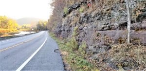
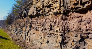
That brings us to today’s yarn. One recent Tuesday evening we were on our way to WIOX in Roxbury when there it was – some fine road work. We love road work; so often it brings to light an exposure of bedrock. Take a look at our photo. It was taken alongside the Susquehanna Turnpike, a few miles west and uphill from the village of Durham. Look again, you might not guess it but there is a lot of geology in there. We geologists always start at the bottom and work our ways up from there. That takes us from the oldest to the youngest – a trip through time.

In this photo the oldest strata are of typical Catskills bedrock, a horizon of sandstone. You might prefer to call this rock Catskills bluestone, it doesn’t much matter. In either case, we looked at the rock and were transported about 385 million years into the past. There we found ourselves in the channel of a substantial river. That’s where the sand of this sandstone had been originally deposited. We walked up to the exposure and held our hands out. We could feel the powerful river currents that had once passed by here. Then they slowed down and then they stopped. This stream had jumped its channel; right here it would never flow again. That’s not as unlikely as it sounds. Streams don’t flow on forever in one channel; they do alter their courses and, long ago, that happened right here. Those sands came to be buried under more sediments, then more and then thousands of feet more. They would soon begin a process of compaction that would, with time, turn them from sediments into the bedrock we see here.

What happened to all those other sandstones – the ones that used to lie above? The answer is that they were all eroded away. We looked up into the sky and “saw’ thousands of feet of sedimentary rock rising above us. And we knew that they had, again so long ago, eroded away. And the last of that erosion is represented by the platform about halfway up our photo. That surface is important. Once, out of the north, an erosive glacier had ground its way across it.

Our photo shows that, above that erosion surface, lies a few feet of – what? – soil? Actually no, this is something else. It’s a few feet of earth that is called a ground moraine. A ground moraine is a relatively thin horizon of material that dropped out of a melting glacier at the end of the Ice Age.

We had stopped along the side of the road, attracted by something that looked of interest. We had taken a photo and had found ourselves another good yarn. This yarn involved an ancient river and a passing glacier. Our yarn was spread out across hundreds of millions of years. It is a good yarn.

Contact the authors at randjtitus@prodigy.net. Join their facebook page “The Catskill Geologist.” Read their blogs at “thecatskillgeologist.”

A Leaning Tree??

in Uncategorized by

A leaning tree?

The Catskill Geologists by professors Robert and Johanna Titus

The Mountain Eagle ; July 19, 2019

Take a look at our photo. Do you see anything of note? Well, if you don’t then you don’t have the trained eye of a geologist. We think you can be forgiven for that, but let’s work on it. After all, that’s what our column is supposed to be all about.

This photo was taken down at the Roosevelt Estate in Hyde Park. We go there for events all the time, so we have learned a lot about the area’s geology. The estate is spread out across the top of an ice age delta and the photo shows the edge of that delta. You probably would never guess it, but the whole bottom of the Hudson Valley was once a great, deep glacial Lake called Lake Albany. All of Hyde Park lies on a delta of that lake. The top of any delta is a very flat surface called a topset. The edge of the delta is a steep slope called the foreset. Our photo focuses on the boundary of the two. The topset is spread out to the right and all of the library buildings lie upon it. The foreset drops off quickly to the left.

A typical delta is composed of cohesive silty sediments and, with its steep slope, the foreset can be a very unstable landscape feature. Delta foresets commonly display what are called rotational slumps. Large mases of the cohesive silt break loose along curved faults and rotate downhill. You might think of this sort of thing as a slow landslide. Take a look at our second illustration. It shows a mass of earth sliding in a clockwise motion down a curved fault line. At the top of the slide trees lean backward; at the bottom, they sometimes lean forward. Now, look at our photo again. Do you see something that you didn’t minutes ago?

So, why are we writing about a feature on the east side of the Hudson River? This column is supposed to be about the central Catskills; isn’t it. Well, again. We want you to have a trained eye, alert to all sorts of geological features that you might be passing on a routine day. Have you ever noticed a leaning tree? Even if you did, did you know what it might portend? Could you possibly have suspected a landslide hazard?

And, in this case, there is something very important: is there a danger that the Roosevelt mansion, Springwood, might break loose and slide downhill? Our photo was taken just a short distance north of Springwood. We were certainly concerned when we first visited so we explored the area. But the news was good; we found no leaning trees close to Springwood and only a relatively few in the vicinity. But there was more: we found few, if any, leaning trees at the bottom of the foreset slopes. It has been our experience that with dangerous slopes, the trees at their bottoms come to be shoved forward. Take another look at our second illustration.

So, in the end, we are not overly concerned about the safety of Springwood and the whole of the Roosevelt Library and Museum. But you can never be entirely certain about these things. You might take a look at the trees where you live.

Contact the authors at randjtitus@prodigy,net. Join their facebook page “The Catskill Geologist.” Read their blogs at “thecatskillgeologist.com.”

Some Shiny Rocks in Plattekill Clove. 6-20-24

in Uncategorized by

Some shiny rocks in Plattekill Clove

Robert and Johanna Titus

The Catskill Geologists; The Mountain Eagle; July 12, 2019


It’s not unusual for us to hear from one of our readers. That’s, after all, why we publish our email address at the bottom of each article. It is also not unusual for them to send us a photo of something worth writing about. That happened recently when someone we know as “Catskill Bear” sent us this week’s photo. Mr. Bear found this rock along the road in Plattekill Clove. He was most curious about the striated and shiny surface he saw on it. That makes up the whole left side of the rock in his photo.

Well, we recognized what this was right away, but we still needed some help on it, so we contacted our friend, Dr. Charles (“Chuck”) Ver Straeten at the New York State Museum, and asked him about it. Chuck is a geologist who knows just about everyhing there is to know about the Devonian age stratified rocks of the Catskills so we knew he would be able to help.

We already knew the fundamentals: what our reader had found was a shiny surface called a slickenside. We had been transported back to a landcape called the Catskill Delta. It was about 385 million years ago, the middle of the Devonian time period, and that delta was spread out across all of today’s Catskills. There was a tropical climate here way back then. And many geologists think that the climate was seasonal with dry months and wet months every year. Much of the delta was blanketed in a common soil type called a vertisol.

Scientists know a lot about vertisols because they exist today. They possess clay minerals that shrink during the dry seasons and expand when they get wet. That creates a back-and-forth motion within the soil. One mass of soil expands and slides past the other during the wet season. It contracts and slides past the other mass in the following dry season. The result of all this are soil slickensides.  And that is exactly what Catskill Bear had found.

But there is more; it seems like there is always more. Chuck has, himself, been interested in Devonian soil slickensides. He has noticed that they are concentrated in certain horizons within Catskills stratigraphy. There are stretches of Catskills stratified rock where they are common and other stretches where they are not. He wondered why.

It’s common for Nature to present scientists with patterns like this. Nature is challenging us: where there is a pattern, then we must seek to learn why. If we meet the challenge and answer that question, then we are likely to have discovered something. It’s a common way that science works, and a fun way.

Chuck developed a hypothesis to explain this. A scientific hypothesis is a tentative explanation. It has not been properly tested and thus has not been proved – not yet. Chuck has long understood that volcanic eruptions can produce the clay minerals that promote expansion and contraction in vertisol soils. His hypothesis is that explosive Devonian eruptions in New England might have showered our region with ash that, potentially, could have been be altered into those “shrinking clays” and thus subjecting local soils to seasonal expansion and contraction. Slickensides would be concentrated in certain stratigraphic sequences because those represent times of volcanic activity. Sounds good, doesn’t it? But this is just hypothesis; it still needs work.

In the end, slickensides are among many, many phenomena that we routinely encounter in the Devonian strata of the Catskills. You too can learn about them. With time, you learn to notice these things. They speak to you about the past. You have become more knowledgeable. Your hikes in the Catskills become such different, more enriched, experiences. And it all starts from reading these columns.

Have you found some interesting geology? Write us about it. We are at randjtitus@prodigy.net. Join our facebook page “The Catskill Geologist.” Read our blogs at “thecatskillgeologist.com


Go to Top