
You can have it both ways
The Catskill Geologists
Robert and Johanna Titus
The Mountain Eagle
Mar. 9, 2018
We write these columns in the hope that you, our readers, will come to pay closer heed to the rocks of our region. That’s a lot easier to do if we put together just the right sorts of articles. We hope that this is one of them. Some time ago we went exploring at the top Overlook Mountain. We have long enjoyed Overlook; it has a fine view of the town of Woodstock and the Hudson Valley beyond. Then there are the scenic ruins of the old Overlook Mountain House Hotel.
Not surprisingly, there is a lot of geology up there. At the height of the Ice Age, Overlook was overwhelmed by the glaciers. They swept up and over the mountaintop and left quite a record behind. If you climb up to the very top where the fire tower is, you can look about and find the scratches left behind by cobbles and boulders dragged across the mountain’s bedrock top by the passing ice.
But, our column today is about that bedrock itself. The Overlook Mountain trail is a very good one. It ascends the southwest slope of the mountain and, almost at the top, it makes a bend around the mountain’s peak. You will have very little trouble noticing the sandstone exposures along the uphill side of the trail. These are likely river channel deposits from the old Catskill Delta that is preserved here. Take a look at our photo. It’s a close-up view of one small stretch of the outcrop. Notice a peculiar aspect of the stratigraphy here. The uppermost half foot of strata dips strikingly to the left. Now look below and you will see some more strata that do just the opposite; they dip to the right. What a strange thing this is; it needs to be explained.
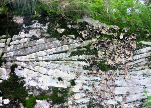
This is just the sort of thing that geologists, like us, always take note of, and it is just the sort of puzzle we like to unravel. Let’s take a crack at solving this mystery. We can start by considering one set of strata at a time. Those upper beds, by themselves, are called planar cross beds. Planar cross beds have distinctive inclines to them and they lie in contact, above and below, with flat-lying surfaces. In this case they speak to us of old river currents, flowing right to left. These currents carried sand and deposited it in inclined beds, dipping downstream.
The lower beds record exactly the same thing, but they speak of currents flowing left to right. How can that be? Rivers, after all, are only supposed to flow in one direction. Our solution to one problem has, ironically, opened up another. That’s very common in all the sciences. Now we need to solve that second one. Like any good scientists, we must do some hypothesizing.
Catskill geologists understand that the rivers which, long ago, flowed across the Catskill Delta were meandering streams. They wandered back and forth across the delta. So this river might have flowed right to left at one time and reversed itself later. But there is another possible hypothesis. If this river had been approaching the coast then it might have been a tidal river, like today’s Hudson. If so, then some of the planar cross beds might have been from some ancient high tide while the other set might have been from a following low tide. They might have even been deposited on the same day!
Which hypothesis is the winner? Is either the right explanation? That’s the sort of thing geologists debate late at night in geology bars.
Contact the authors at randjtitus@prodigy.net. Join their facebook page “The Catskill Geologist.” Read their blogs at “thecatskillgeologist.com.”


How does a solid sheet of ice bend and conform to curves and indents in solid rock leaving meandering grooves? A video showing the underside of a glacier traveling along reveals that as one would expect, it behaves like a stiff solid and travels over depressions without touching them. Have a look:
https://www.youtube.com/watch?v=njTjfJcAsBg
Regarding the sandstone cross bedding, flowing water has produced the same cross bedding effects while the current was traveling in the same direction. This has been proved fluvial tank tests. And in much wider areas than rivers today, some over regions of a hundred or more miles. In fact water-formed dunes and antidunes produce overlapping layers of cross bedding at different angles. If the sand grains under a microscope are moderately sorted or poorly sorted, this for instance would argue for water borne sedimentation. The Hopeman sandstone in Scotland for instance is a water current borne sandstone that has even more pronounced cross bedding.