"I will never kick a rock"

Monthly archive

August 2023

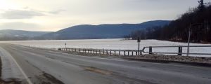
A vee-shaped stream – 8-31-23

in Uncategorized by

A “youthful” stream?

The Catskill Geologists

The mountain Eagle

Robert and Johanna Titus

Feb. 16, 2018


   We have been trying to find “winter” topics to write about lately; after all, it is that awful season of snow and ice. This is not a geologist’s favorite time of the year and for good reason. We enjoy getting out during the warm months. We can do so many more things then. But actually, there are things that a geologist can do best in the winter, things that just don’t work out in the summer. Mainly, we can see features that we can’t in the summer. During those warm months all the foliage is decked out. Leaves are pretty; leaves are nice, but they get in the way of seeing the landscape.

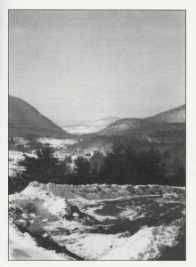
Well, that is just not the case in the winter. Take a look at our photo; it shows a very small valley lying alongside a road. In the summer you can go there and hardly see the valley at all. It is small and all the leaves obscure the view. Take another look at our photo and start to form an impression of this valley. It is so small; the trees serve to give you the scale. There is a stream in it, but it too is very small, perhaps even tiny. This little creek dries up in the summer but it is active throughout the rest of the year.

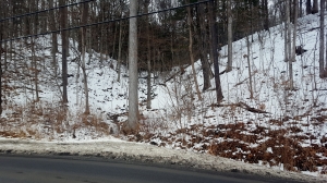
Even a little creek would have few problems eroding a valley as small as this one, and that is the case here. This little creek is too small to have a name, but it did carve its own valley. And it is not likely that it took very long. You can be forgiven if you deduce that this is a young stream; it does not have much of a history.

The slopes of this little valley are pretty steep and that is of some importance. A long time ago (in human terms) this sort of stream was formally dubbed “a youthful stream.”  It was argued that streams had life cycles; they passed through stages called youthful, mature, and old age. Streams were supposed to have had lifetimes, just like we do. This view of aging steams was described as “the fluvial cycle.” It was the invention of Harvard geographer William Morris Davis. A century ago, it was a powerful, influential scientific concept.
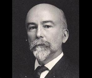
W.M. Davis

When we were in college those views still commonly prevailed, but that would not be for much longer. This view of a fluvial cycle was very appealing but it just was too simple. Real streams do a lot more than just get older. They perform all sorts of erosional and depositional tasks, and they produce all sorts of landscape features. It is just too simple to call them young, mature or old age. The fluvial cycle has largely disappeared from geology textbooks. But hold on, maybe we should be careful about all this; let’s not be in a big hurry to be modern. Let’s look at this unassuming little stream some more.

Our little stream descends the slopes of Catskill Creek. On its way it cuts through deposits of glacial debris. Those deposits formed very late in the Ice Age, in fact these deposits were virtually the last things produced by ice age processes. They probably don’t date back more than 15,000 years. That’s a very brief period of time – in geology. These deposits are, in short, genuinely youthful. William Morris Davis regarded steep slopes as diagnostic of youthful streams. This one is just what he had in mind.

We will return to this theme in later columns, but for now we would like it if you, as you travel about, notice similar streams. Look for small streams with vee-shaped valleys. We think that there are a lot of them in the Catskills. They are mostly very late ice age features. William Morris Davis would have been glad to see them.

Contact the authors at randjtitus@prodigy.net. Join their facebook page “The Catskill Geologist.” Read their blogs at “thecatskillgeologist.com.”


Ramp and pluck 8-24-23

in Uncategorized by

“Ramp and Pluck” — The Catskill Geologists

The Mountain Eagle; Jan. 26, 2018

Robert and Johanne Titus


  We have been nosing around, looking for geological features that work well in the winter. Last week we found an impressive view of Glacial Lake Schoharie, an image of that old lake that positively shined in the winter snow. That was on Rte. 145, just west of Middleburgh. Just a few minutes later, on the same drive, we stopped and took a good look at Vroman’s Nose, just east and again on Rte. 145. We noticed something we had not seen before. That’s this week’s column.

Take a good look at our photo. It’s a cross section view of the Nose; it’s the best view you can obtain. It show’s all the structure of what is called “ramp and pluck” topography. Notice that the right (north) flank of the mountain tapers off gently; its slope is relatively low. The left (south) flank, however, is far steeper. All this reflects the behavior of the glacier that once passed across the Nose.


That was the Schoharie Creek Valley glacier. It moved right to left, or north to south in our photo. The ice scoured its way up the north-facing ramp of the mountain. Then the ice passed across the crest of the mountain and soon it yanked, or plucked, an enormous mass of rock right out of the south side. That’s the south facing cliff. Well, hence the name ramp and pluck. It’s a very descriptive term, an unusually good choice of words for science.

Well, we already knew all this; we have been here so many times before. But on this visit, there was something different. It was in the snow. Notice the nice thick blanket of snow on the ramp side. Then see how the snow is nearly absent from the darker, steeper south facing slope. The plucked slope is a virtual cliff. Snow can accumulate on the ramp side but it cannot on the plucked cliff. The two sides stand out in sharp contrast, thanks to the snow.

None of this is terribly important; you won’t find anything like this discussed in a glacial geology textbook. But it is an aesthetic; isn’t it? And it helps train the eye, doesn’t it? And perhaps that does add some “importance” to what we are talking about. Geology is an experiential science; it is widely said that the best geologist is the one who has seen the most rocks. But, also, perhaps it is the best geologist who has seen the most rocks in the best way!

And that is the point here. We seem to have found a new way to look at geology in this season of the snow, and that new way is likely to offer insights as we continue our explorations. We intend to devote ourselves to noticing more winter images of this sort; there may be other interesting snowbound features out there.

But, in the meantime, it is training your eyes that we are interested in today. Ramp and pluck topography is important and common. Perhaps this is the time of the year when we should be looking for it. Perhaps you can keep out a sharp eye too.

Contact the authors at randjtitus@prodigy.net. Join their facebook page “The Catskill Geologist.” Read their blog “thecatskillgeologist.com,”

A landslide in Schenectady 8-16-23

in Uncategorized by


The Schenectady landslide.

The Catskill Geologists

The Mountain Eagle; Feb. 2018

 Robert and Johanna Titus


Have you heard about the recent (2018) landslide in Schenectady? A mass of mud slid down a steep hill along Nott Terrace road and did major damage to two houses. It injured at least one person and left perhaps two dozen others looking for a home. This is the type of story that we have been covering for more than ten years now. Landslides are frequent geological hazards up and down the Hudson Valley and throughout parts of the Catskills. We think that this threat should be better known by you, the public.

    Reporter covers Landslide story on Albany Channel 10

We need to give you a little background first. Back in the later stages of the Ice Age, much of the Hudson Valley was submerged in a body of water called Glacial Lake Albany. That included all of the land that is now Schenectady and Rotterdam. The Mohawk River was a powerful flow back then, carrying large amounts of water from melting glaciers. It flowed into Lake Albany and carried huge amounts of sediment, which were deposited into what became a very sizable delta. Those deposits were mostly sand, silt and clay; when wet enough they become mud.

The lake eventually drained, and the delta was left behind, literally high and dry. It provided ideal conditions for people to settle. Delta tops are flat and easy to develop. It was simple to lay out roads. Settlers could build homes with deep, well-drained basements. Those homes were high enough above the Mohawk River so they did not have to fear flooding. It’s a remarkable thing to realize that both Schenectady and Rotterdam are where they are because of the Ice Age.

Over the millennia, rivers cut canyons into the delta and there lies the problem. Those canyons often have steep slopes and, when the delta deposits become wet from rainfall, they turn into mud and that mud can let go and slide downhill as mudslides. That happens from time to time. One of the most recent such events occurred in the spring of 2004. Heavy rain, the previous autumn, had soaked the ground at 1st Avenue in Western Schenectady. The Mohawk River and an unnamed creek had eroded into the delta deposits there and created a steep slope, 80 or 90 ft. tall. When the slide began, it caused six houses to slowly subside. It is our recollection that they were all condemned. In January of 1996 a similar event occurred on Broadway, near Rte. 890 where Pleasant Valley Creek created a similar steep slope. That landslide, occurring after heavy rains, killed one man. The Nott Terrace slide is an event very similar to these.

As geo-journalists, we have been following this story for years. We have seen similar events in Delmar, Greenport, Rennselaer, Germantown and just a few years ago in New Baltimore. We fear that many more such slides will occur throughout the Hudson Valley, including at historic sites in Hyde Park. All of these slides involved the sediments of Lake Albany. These silty lake sediments soak up a lot of rainwater. When they reach a certain point, they become unstable. Great curved fractures open up and masses of earth slide along the curves of what are called rotational slumps.

All this is important; it is our region’s greatest geo-hazard. This will happen again.

Reach the authors at randjtitus@prodigy.net. Join their facebook page “The Catskill Geologist.” Read their blogs at “thecatskillgeologist.com.” Watch for their columns in Kaatskill Life and Upstate Life magazines. They are frequently in the Woodstock times.


A U-shaped valley – August 10, 2023

in Uncategorized by

Our reader’s rocks – Ice in Grand Gorge Gap?

The Catskill Geologists

Robert and Johanna Titus

Sept.15, 2017


We always give our email address at the bottom of each of our articles. And we can always be approached on our facebook page, so we hear from a lot of our readers. Often, they have questions, and we are usually able to help them with answers. Every once in a while, we thought we would answer one of these queries in the form of a column so here goes the first.


Recently we heard from a Gerry Hubbard. He sent us a photo of Grand Gorge Gap and wanted to know what the rounded hump on the right is. Take a look at our photo and you can see that hump. We had been wondering the same thing for years and so Gerry’s request got us to do something about the problem.

The first step is to get our topographic maps out and loo
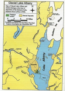
k at them. We found that the Roxbury 7 1/2 minute quadrangle map displayed the Gap. We found that the hump has a name; it is Jump Hill. Then we went back to our photo. The “hump” is actually something that lies in between two valleys. The contour lines on our map indicated a steep but steady slope for each of the two valleys. Each one of those is what geologists call a U-shaped valley. Every trained geologist on the planet Earth quickly recognizes the ice age history of such a valley. They record the passage of glaciers. As ice squeezed through a valley it ground away and eroded the bedrock. The shape that offers the least resistance is the U. Not surprisingly, over a period of time, glaciers will carve those U’s into the bedrock landscape. It gives each of them a path of least resistance. That forms a remarkably picturesque image and that helps make glaciated landscapes so attractive. We geologist are most fond of these U-shaped valleys.

Well, we studied the map and our photo and started speculating about what had happened here, way back, near the end of the Ice Age. Speculation is a word that scientists like to avoid; it sounds so – well speculative. So we use the word hypothesize instead. It sounds better. We hypothesized the following story: We hypothesize that the larger U-shape, on the left, is the older of the two. We think that a sizable glacier entered Grand Gorge Gap and began eroding the large U-shaped valley. Somewhere along the line, the ice was diverted and a second stream of it passed through what is the smaller, and we think younger, U-shaped on the right. All this erosion left Jump Hill in between.

We hope that Gerry likes our hypothesis. It conjures up quite an image. We travel north on Rte. 30 to where we can park and see this view. In our mind’s eyes we can imagine the advance of these glaciers; we can watch them carve the shapes of Grand Gorge Gap. That view gives us a whole new perspective on this site.

We hope you enjoyed our hypothesis. Perhaps you have a location that we could write about. Let us know.

Contact the authors at randjtitus@prodigy.net. Visit their facebook page at “The Catskill Geologist.” Read their blogs at “thecatskillgeologist.com

The bottom of a lake. Aug. 4, 2023

in Uncategorized by

A great glacial Lake

The Catskill Geologists

Mountain Eagle; Jan. 19, 2018

Robert and Johanna Titus


They say that you can’t make something out of nothing. “They,” of course, may well be wrong; it seems “they” usually are. We began to think such thoughts while traveling on Rte. 145 where, heading east, we were descending the hill on our way to Middleburgh. It was January, and that made the landscape covered with snow. And all that snow made the landscape before us all the more stunning. Take a look at our photo.

There, to the right of the highway, in all its snowy whiteness, was a great field of nothing. True, there were the remains of last summer’s corn, but the rest was broad, and flat, and white; it was indeed nothing. But not to us; we saw something; we were ready to do the impossible: to make something out of nothing.

We have written about this before; when a geologist sees a big flat nothing in the Catskills, then that geologist starts to think of a glacial lake. This one has a name; it is Glacial Lake Schoharie. The bottom of that lake was stretched out before us and it was big. When we got home, we got our maps out and found that the lake was about a mile across at Middleburgh. It stretched off to the north for miles and it did the same to the south.

But how deep was this lake? To answer that simple but important question we have to do a little elementary geology. We know that the Schoharie Creek Valley glacier dammed the valley to the north so just how did water get out of this basin? To find the answer to this, you have to continue to drive east on Rte. 145. You take a long hillslope up from Middleburgh until you reach an elevation of 1,200 feet. That’s a drive of about two miles. At the top of the hill, relatively steep slopes descend to the road. Soon you pass what is called Vlaie Pond. This location is the site of the Franklinton drain. Water from Glacial Lake Schoharie drained through this gap. It continued on down Catskill Creek as a very powerful flow.

The elevation at lake bottom, at the bottom of the hill, was at about 600 feet so that makes the old lake about 600 feet deep; that’s a lot of water.

If you make this trip we would like you to pull over and get out at the very top of the hill. Try to imagine the flow of water that passed through here late in the Ice Age. Look back to the west and see the lake spread out before you. It can be quite an experience to do this.

We have, in fact, written several articles about this lake in the Schoharie Creek Valley, but what impressed us this time is the impact of the view you get from the bottom of the hill. Look at our photo again. It nearly overwhelms you. We think it is one of those great experiences given to a geologist. It’s the sort of thing that we run this column in order to do.

Contact the authors at randjtitus@prodigy.net. Join their facebook page “The Catskill Geologist.”

Go to Top