An ancient river channel
The Catskill Geologists
The Mountain Eagle Oct. 20, 2017
Robert and Johanna Titus
Every so often, in our columns, we refer to a sizable ledge of sandstone as being the cross section of a Devonian age stream channel. The Devonian part is easy; all of the bedrock in the Catskills is Devonian in age (419 to 359 million years ago). But what about the stream channel part? How, exactly, is it that we know that?
It’s a fair question and we think we should take a crack at answering it. Let’s do that this week. Recently we were over at North Lake, on the Catskill Front. Our primary interests on that day was the ice age history of the land that lies between North and South Lakes. But, we came across a massive ledge of light colored sandstone and it caught our eyes. We took a good look and a good photo. We had seen some interesting structures within the sandstone.
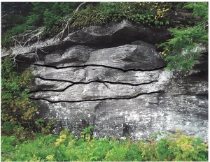
Well, what we had seen were a number of erosion surfaces. We printed up our picture and then inked in those erosions. Take a look at our photo. This had been a sizable river. Its sandstones must be twelve feet or so in thickness. You need a river pretty much that deep just to accumulate all that sand.
This river lay at the bottom of the steep slopes of a mountain range. These were called the Acadian Mountains and they towered above what is now western New England. Streams, that descended their slopes, would have flowed out onto what we call the Catskill Delta. They carried a lot of sediment, most of it sand. These sands came to be deposited where North Lake is today.
These were likely large and powerful streams. They would have been occasionally subject to great flooding events. It is only logical to think that, from time to time, it rained a lot up in the Acadians. Those storms generated powerful flows of water, carrying large amounts of sand. When the streams flowed far enough out onto the delta then their flows slowed down and the sand came to be deposited.
If all that is true, then we should see the evidence in outcroppings, such as the one in our photo. We think that the evidence is there – in the inked lines. Each flood event must have reached a peak, when the flows were at their maximum levels. Those flows, it only seems logical, would have eroded into the sediments of the stream channel. When we inked in those erosional surfaces, we thought we had identified such events. The bottoms of these surfaces are concave and they, each one of them, look like features that had been eroded.
There are at least four of these erosional surfaces in our outcrop, or about one every three feet. We think that each of these surfaces records the peak of a major flood event. During that peak, the flood currents would have picked up large amounts of sand and swept it away. As the flood passed its peak, currents slowed down and most of that sand would have come to rest as a new deposit. Most of the sand in between these erosion surfaces seems to have been deposited at the end of its flood or during quiet times that followed.
How often did these floods occur? We can come up with a very approximate estimate. There are about 4,000 feet of sedimentary rock found in this Devonian sequence and it took about 11 million years to deposit them. That averages out to about 2,700 years per foot of sedimentary rock. If there were three feet per flood and if all the above is true, that means that these floods occurred every 75,000 years or so! That’s a lot of time.
But, most importantly, all this is consistent with the notion that such sandstone ledges were once stream channels.
Contact the authors at randjtitus@prodigy.net. Join their facebook page “The Catskill Geologist.” Read their blogs at “thecatskillgeologist.com”