"I will never kick a rock"

Monthly archive

February 2022

A Hike up to Kaaterskill Falls, Pt. 1, Feb. 17, 2022

in Uncategorized by


The New Kaaterskill Falls trail – Part One: Bastion Falls

On The Rocks, The Woodstock Times, 2016

Updated by Robert and Johanna Titus         


We begin today a series of columns about the newly renovated trail leading up to Kaaterskill Falls. We want you to go and see what has been done there; it’s a wonder. We started, of course, at the bottom; geologists always do it that way; that’s where the oldest rocks are. You start at the bottom and work your way upward, traveling through time into younger and younger strata. Hereabouts the bottom is just below the bridge at Bastion Falls.

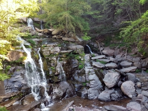
Bastion Falls tumbles over a thick ledge of rock just right and uphill of the highway, Rte. 23A. It is a massive ledge of tan colored sandstone. Whenever we see a thick sandstone of this sort we envision a river – a big river. These sandstones had, long ago, been sands, and those sands had been deposited in the channel of that river. What a thought this is; we were looking at a modern creek and its waters were tumbling over a ledge of rock created by a much larger river, one that had occupied this very space – about 380 million years ago. The two rivers cross each other in space, but not in time. Roads can intersect each other but rivers cannot – except in time.

But we were only looking at a fragment of something much bigger. Our Bastion Falls River had been only one among many, many others. We turned around and looked up to the top of the clove, rising hundreds of feet above us. Much of what we saw was composed of many other petrified river channels. In between the channel sandstones were the silts and clays of ancient floodplain deposits. Again, we looked up and recalled what we have long known, all this that we call the Catskills is a great petrified delta. It once was a delta that would easily have rivaled the Mississippi River Delta of today’s Louisiana. It has a name: the Catskill Delta. We turned around and continued our climb up a scenic modern canyon but, at the same time, we were acutely aware that we were passing across the top of an ancient delta.

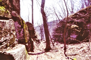
A lot of people confuse Bastion Falls with Kaaterskill Falls, but Bastion is just the warmup for the main act. The falls, here, need more explicit signage. We knew better; we climbed down to the stream bottom below the falls. There we saw a number of very large boulders (the right side of our first photo). These were tan sandstones too; we surmise that they had, perhaps ages ago, weathered free from the main ledge and fell to where we saw them.

It would have been easy to ignore these boulders; they really seemed to be thoroughly routine rocks. But we were curious about them; we scrambled around and looked them over. It was worth the effort. Soon we found something special: several feet of a fossil tree trunk, lying of the surface of one of those boulders. It had been a fairly sizable tree with a four-inch diameter. Unfortunately, its roots and foliage were absent, long lost to the vicissitudes of time.

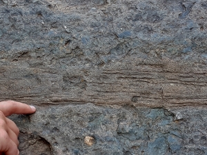
We had traveled back in time to visit the fabled Gilboa Forest. That was the forest of primitive trees that had, during the Devonian time period, those 380 million years ago, lived upon the floodplains of the Catskill Delta. We did not have a specimen well enough preserved to put a name on it, but we knew with certainty that they had been trees; we could see their bark. You don’t find fossil tree trunks in the Catskills all that commonly, so this was worth our efforts. But it soon got better; we poked around and in just few minutes we found sections of two more fossil tree trunks on two more of those boulders. Finding three trunks in just a few minutes is genuinely unusual. We needed now, as scientists, to conjure up a story to explain this remarkable happenstance.

It wasn’t hard for us to come up with a hypothesis. Our fossil trees had all been buried in the sands of a sizable river channel. Sizable rivers have, from time to time, sizable floods. It was easy for us to look into the past and envision three of those floods, each carrying one of those tree trunks. What a thought! All around us recreational hikers were climbing up the yellow trail. They were admiring the beauty of the canyon. We had been doing the same – until we had taken a detour through time.

Well, you see what we are doing here. Over the course of the upcoming weeks, we intend to continue with a series of articles which will take you up the Kaaterskill Falls canyon. We will see it as it is today, and we will marvel over how recent engineering has improved the experience here. But our main goal is to travel through time and see this vicinity as it was during the Devonian time period, and also about 14,000 years ago during the ending phases of the Ice Age. This canyon has always been a wonderful place for you to visit. We hope to give you the kinds of knowledge that will make it far better.

Contact the authors at randjtitus@prodigy.net. Visit their facebook page “The Catskill Geologist” and their blog site “thecatskillgeologist.com.”


The Cold in Texas – Feb. 10, 2022

in Uncategorized by

THE CATSKILL GEOLOGISTS – ROBERT AND JOHANNA TITUS

The Mountain Eagle Nov. 29. 2019

THE TEXAS COLD


This winter’s weather news from Texas has been horrendous and we are sure you have heard about it. The temperatures went down to as low as 9 degrees overnight in the Houston area. It snowed, pipes burst, and food and water shortages resulted. The cold has been called historic and it was. We have a child and two grandchildren down there, so this was a real concern.

Why? We think there is something going on that you need to understand. What happened in Texas has occurred up here as well; it’s just that we don’t notice it so much. It all began with global warming and its effect on the jet stream. Decades ago, when global warming was still just hypothesis, that hypothesis predicted that polar regions would warm up a lot more than temperate regions. Northern Alaska would warm up a lot more than New York State. It has. The Arctic has become not nearly so much colder than lower latitudes. Importantly, the temperature boundary between Arctic and temperate climes has blurred.

That led to results that had not been anticipated; the jet stream was affected. We hope you know that the jet stream is a flow of air that undulates up and down as it continuously flows from west to east. See our diagram. This brings us a lot of our weather, especially winter storms. Historically, the jet stream has been a relatively gentle up and down undulation. See the blue dashed wavy line on our diagram. That is best developed when the contrast between cold Arctic and warmer temperate warm is sharpest.

But when the Arctic warms up the jet stream is altered. The up and down undulations become shorter and steeper; they become more pronounced. See the red solid wavy line on our diagram. Their west to east motions also slow down considerably. All this can have a dramatic effect on climate and weather. The down undulations contain the coldest air. When those jet stream undulations spread to the far south, they can bring unusual, even historically cold air into a region where that is not typical. Then because of the slow movement, that cold can stay put on a region for a prolonged period of time. That’s what has been happening to Texas this winter.

Well, these undulations pass through the Catskills too. You will hear each one described as an Arctic vortex. But, up here, we just do not see them as historic events. But this was a very serious event in Texas. We think you should be watching the jet stream diagrams on your local TV forecasts. You can also probably find a webpage that will keep you up to date on the jet stream. You may come to better understand what is happening. And that’s, after all, what our column is all about.

Contact the authors at randjtitus@prodigy.net. Join their facebook page “The Catskill Geologist.” Read their blogs at”thecatskillgeologist.com.”

Rip’s Spillway – Feb. 3, 2022

in Uncategorized by

The Legend of Sleepy Hollow

The Woodstock Times – On the Rocks

Updated by Robert and Johanna Titus


For most of the 19th Century the Rip Van Winkle House stood near the top of the canyon at Sleepy Hollow. It was a restaurant and inn that served the needs of the many travelers of the Old Mountain Road. That road stretched off west from the city of Catskill and it ascended all the way up the Catskill Front and beyond into the Catskill Mountains. It was once one of the great highways of the region. Today, Rt. 23A is its only descendent, and that road climbs up Kaaterskill Clove, the old path has long ago been bypassed.

But the old highway is still there in the form of a very fine hiking trail and it’s open to horse riding as well. The Rip Van Winkle House burned down in the early part of the century, but its site is still very easy to find. Sleepy Hollow is a very typical Catskill Clove. It has a nice rocky mountain stream, and the cool, shady location is still an ideal rest for today’s recreational travelers. It’s the stream that made this location. The creek has been here since the ice age ended and the powerful erosive currents that were generated by the steep slopes have carved the canyon.

The creek here is what geologists called a misfit stream. That is the stream is much smaller than it should be in order to have carved the canyon in which it flows. Little valleys are carved by small streams and big canyons are carved by big streams. That’s the way it should be, however that’s not the way it is here. But that is not to say that there is any real mystery. Geologists encounter many misfit streams and the explanation for the bad fit is almost always involved with an ice age past.

Back at the end of the last ice age there was a very large amount of ice being melted in the face of warming climates. Not surprisingly, many streams were temporarily glutted with meltwater. Great foaming, churning whitewater streams existed where today quiet little brooks are the norm. That’s what happened here. If you climb up the canyon from the Rip Van Winkle House site, you will soon encounter an old stream channel that branches off to the right (north). It’s a fine channel, but it is dry. If you follow it and climb quite some distance, about 500 feet, nearly straight up, you will ascend to a gap in the mountain. To your right is something known as Rip’s Rock, a great picturesque ledge that reaches out into the Hudson Valley. To your left the same ledge merges with the Catskill Front. In between is the gap of which we speak. It is an old meltwater spillway.

Toward the end of the ice age there was a glacier in the Hudson Valley that banked up against the mountains right here. That glacier was melting, and water was rushing off of it. The water had to go somewhere, and it was channeled right where this dry spillway is. For a relatively brief period of time there was a great rush of water right here. All that foaming, churning, swirling water we spoke of earlier was funneled through this gap. Brief as that flow was, it was very powerful and erosive enough to produce the gap we see here.

This sort of thing is called a paleo-form. That is to say that this landscape feature is literally a fossil, or relic, of different climatic conditions in the past. This is a relic of that very brief moment in time when the ice was melting. Once carved, such a feature is very difficult to erase, today’s erosion rates are so slow.

We like the term “fossil spillway” for this feature, but some geologists like to make it a little more dramatic and they would call this a fossil waterfall. That’s an exaggeration, but it’s really not too far off the mark, there was once a very powerful flow here, close to that of a true waterfall. If you climb up and down this spillway, try to keep that in mind. Make the fossil image part of what you see here. It should not be too difficult to imagine the great fossil flow that once was here. It was ice cold, extremely fast and, more than anything else, powerful. Above it there was still a very sizable glacier. The ice was wet, gray, and dirty; it was melting so quickly that you might say it was disintegrating. But the overpowering impression you would have had here back then was the noise. This fall of the water was loud, a steady mind-numbing roar. How ironic, how wrong it is that this is called “Sleepy Hollow.”

Contact the authors at randjtitus@prodigy.net.”  Join their facebook page “The Catskill Geologist.”

Go to Top