"I will never kick a rock"

Monthly archive

January 2022

Rip’s Rock- Jan 27, 2022

in Uncategorized by

Rip’s Rock

On the Rocks; The Woodstock Times

Updated by Robert and Johanna Titus


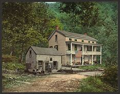
One of the nicest hikes along the front of the Catskill Mountains is the trek up the Old Mountain Turnpike. Today the turnpike is just a hiking trail, but in the 19th century it was one of the region’s most important highways. It was the dirt road that transported carriages up the Catskill Front to North Lake and into the Catskills beyond. Many of the people who made this journey were on their way the Catskill Mountain House Hotel. The trip up the mountain was a tough one, for horses and people alike, and so, not surprisingly, there was a small halfway house along the way. Coaches stopped and passengers could refresh themselves while horses rested a bit. This was the old Rip Van Winkle House.

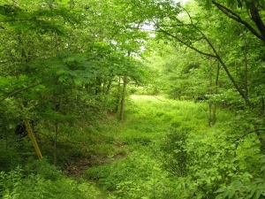
New and better roads left the old highway obsolete and abandoned. But today you can still follow the old turnpike. From Rt. 23A in Palenville, head up Bogart Road and watch for Mountain Turnpike Road. Turn left (west) and at the end of this road is the trailhead and parking. After about a 45-minute hike you will reach a dramatic hairpin turn in the trail where it crosses a mountain stream. That’s the site of the Rip Van Winkle House, just a little bit of foundation remains.

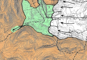
We enjoyed this hike just for the pleasure of it, but I had some geological interest as well. On the map of this area is labeled “Rip’s Rock.” Whatever that might be, it piqued our curiosity and we wanted to find out more about it. The best topographic map we could find showed a great ledge and we wanted to find out what its geology was and maybe also answer the question of how it got there. The problem was that Rip’s Rock was a full 600 feet straight up, not quite a vertical cliff but a pretty steep incline.

Actually, there was one other problem: there are about a dozen or so smaller ledges between the Old Mountain Turnpike and the great ledge of Rip’s Rock, each one, it seemed, was determined to slow down our climb. They did, but eventually we found ourselves at the base of the last and greatest ledge, Rip’s Rock itself. It took a while, but we found a cleft in the ledge and access to the top.

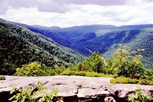
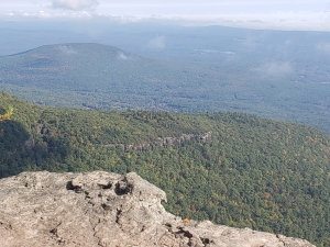
Reaching the top of any great ledge is one of the great experiences of the Catskills. It’s something like rising to the surface of the sea after a deep dive. As your head emerges above the top of Rip’s ledge the whole sky opens up, especially to the east, as the panorama of the Hudson Valley appears. Below is the ravine that cuts into the mountain. Its formal name is “Rip Van Winkle Hollow.” Stony Brook, the mountain stream here, has been cutting into the Catskill Front since long before the last glaciation. In part, that’s why Rip’s Rock is here; the ledge was left behind by the erosion of that mountain stream. It’s the top or lip of the canyon.

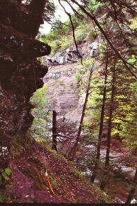
But there is much more to the story of Rip’s Rock. We soon found the evidence that we had suspected since we first gazed upwards at the ledge. The exposed bedrock, up at the top, has been ground and polished by the passing of ice. More than anything else Rip’s Rock is a monument to the ice age. From about 22 to 14 thousand years ago there were several episodes when masses of ice passed across the ledge. The ice acted like sandpaper and ground the ledge into a smooth surface. Cobbles and boulders dragged along added gouges or striations into the surface. Also, the moving ice adhered to the bedrock and yanked loose very large blocks. This, more than anything else, left the jagged cliff that we see here.

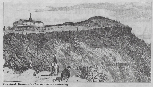
Rip’s Rock is a feature that we have seen before in these columns. It’s called “ramp and pluck topography.” The ramp is a gentle slope ground into the top of a hill by passing rock while the pluck is the jagged front left when the ice yanked loose its large rocks. We see them in many Catskill locations. The ledge at the top of Overlook Mountain is the nearest example. So too, are the Palenville Overlook and Pratts Rock in Prattsville. We have talked about all of those in past columns.

Rip’s Rock is a great hike with a wonderful vantage point at its top. You can stand at the top and gaze out into the breadth of the Hudson Valley. But as we said, this is also a monument to the ice age. When you stand there atop the Catskills you must imagine a few thousand feet of moving ice above you. It’s the Hudson Glacier slowly moving down the Hudson Valley. In the darkness you can hear the groaning and grinding sounds punctuated by sharp cracks. Every once in a while, however, there is a truly loud crack: That is rock breaking loose as Rip’s Rock is being shaped by the ice.

Contact the authors at randjtitus@prodigy.net. Join their facebook page “The Catskill Geologist.”

Poet’s Ledge -Jan. 20, 2022

in Uncategorized by

A hike to Poet’s Ledge

Windows Through Time; The Register Star; Oct. 4, 2012

Updated by Robert and Johanna Titus


We wonder how many of you understand just how deeply philosophical we geologists can be. We tend to find ourselves drawn to some fine geological location; then we come to a pause in our rambles, and we drift, insensibly, into deep trance-like thoughts, usually involving images from the immensity of time.

Well, it happens to us–all the time. One of our favorite locations for rambling into the past is a trek to “Poet’s Ledge” in Kaaterskill Clove. If that sounds like a nice place to hike to, then you are right. It’s a gorgeous ledge of sandstone, perched near the top of the eastern end of the clove. It has a spectacular view of this spectacular chasm. You gaze west, and you take it in–in its entirety. It can become a profoundly philosophical experience, an almost dangerous one.

From up there, the clove is almost unblemished. You can see the highway that ascends it, but very little of anything else “civilized.” It’s almost pure raw wilderness from up there. We geologists gaze into the clove and see it as it developed, probably over the past 120,000 years. Much of the clove was eroded towards the end of the Wisconsin phase of the Ice Age. That was a time, between 10,000 and 18,000 years ago when the glaciers that had over-ridden the Catskills were in full retreat. They were melting away and enormous cascades of water must have been coming down the canyon of Kaaterskill Clove.

When we find ourselves at the top of Poet’s Ledge, it is impossible for us not to ponder such moments. We look up the clove and I see glaciers in the highlands. In our mind’s eye it is always an overcast day. The weather is unusually warm for the Ice Age, but this is the end of that time and warm is okay. The glaciers up there are gray on this cloudy day. They are totally disintegrating in the warmth. We always pick the day when the melting is at its all-time peak. Actually, we pick the very hour when the flow hits its maximum. When we are in a mind’s eye mood, we can do this sort of thing.

We look up the clove at that great high-elevation ice once again. Then we notice that, exactly where Haines Falls is today, there is a break in the ice. A roof has caved in right here, and we can see a massive current. It is an absolutely enormous fire hose of ice water. The flow comes from a hidden sub-glacial Kaaterskill Creek. It reached where the falls are today and then momentum carries it forward so that it could bore its way through the ice and create a great cavity. We gaze at the flow of water passing through that cavity.

Below, there is, once again, a roof of ice. Much of Kaaterskill Clove is still filled with ice. The creek is confined to a tunnel passing down the canyon beneath that ice. It is a very erosive flow of water and much of what we know as the clove today is being carved down there.

Across the clove is another flow of water. It pours off the mountaintop, just west of Indian Head. The water, up there, is visible, but it quickly disappears into another hole in the ice. There are two sub-glacial torrents in Kaaterskill Clove and now, for the first time, we notice and appreciate, and understand the terrible muffled roar that we hear.

The two sub-glacial flows form a confluence immediately below us, almost a thousand feet down. All downstream from here the roof of ice has entirely caved in. The torrent of water continues rushing down the lower canyon. Right now, the “Red Chasm” of Kaaterskill Clove is being given birth to by the powerful, raging, foaming whitewater torrents. From here echo’s a thundering roar, nothing is muffled about this sound. It deafens the ears.


This panorama from Poet’s Ledge is a horrifying scene of nature’s rawest power. The sights, the sounds, and the pounding vibrations all combine to make a jarringly terrifying scene. The pounding meltwaters are cascading, crashing, coming down the canyon with the power of a small asteroid.

And then it all ends; we have returned to the beautiful vista of today’s Poets Ledge.

Contact the authors at randjtitus@prodigy.net. Join their facebook page “The Catskill Geologist.”


Cold enough for you? Jan. 13, 2022

in Uncategorized by

Cold Enough for you?

The Register Star

Updated by Robert and Johanna Titus

Jan 13, 2022


Our Catskill region summers generally bring wonderful weather with dry air and cool nights. Our Catskills Autumns are spectacular with their foliage. Our winters are dreadful and once again it is that time of the year. We stoically accept the onset of another cold season and make do with the holidays as some sort of compensation. Few of us, however, know or even wonder why we must endure this annual season. Do you? Many of you might be able to give a reasonably good explanation for our winter season in terms of the Earth’s orbit about the Sun. Many, or even most, of you, however, might flub the story; it is just a little too complex for a quick, glib explanation.

But it really doesn’t matter; we are not interested in the standard astronomical explanation of winter. We would like to consider a deeper reason, in fact, the real reason it is cold out there right now, and that has little to do with the Earth’s orbit and it has a lot to do with the Catskills and their geological history. If that surprises you then read on:

Even if your astronomy is not very good, most of you can probably run through a quick description of the Greenhouse Effect, it’s one of the leading environmental fears we face today. Briefly, our world’s industries are burning fossil fuels and pumping out large quantities of carbon dioxide into the atmosphere. Carbon dioxide traps solar energy much the way the glass traps solar energy in a greenhouse. As industrial production of carbon dioxide continues, it may be that the Earth’s climate will warm up with all sorts of unfortunate side effects. Such a fate is sometimes referred to as the “Greenhouse Earth.”

But what if it were the other way around? What if the quantities of carbon dioxide were declining instead of increasing? That gets us to a term which is rarely used – the “icehouse Earth.” That’s certainly not anything that anyone has been much worried about, but it actually has happened, and that gets us back to the Catskills.

The Catskill Mountains are composed of sedimentary rocks that date back to the Devonian time period. This was a time when the world was truly a Greenhouse Earth. There was 16 times as much carbon dioxide in the atmosphere then as is today. That greenhouse effect must have been enormous. But it was not to last. Off to the east, in what is today’s New England, there was a rising mountain range – the Acadian Mountains. As their uplift continued, they reached elevations that may have rivaled those of the Himalayas. Rising mountains are subject to chemical weathering and erosion. Those processes converted Acadian mountains into sediment which, eventually, hardened into the rocks of the Catskills. What is critical here is that the processes of chemical weathering consume carbon dioxide, they take it right out of the atmosphere. As the Acadians weathered away and the sediments of the Catskill accumulated, the amounts of carbon dioxide in the atmosphere dropped dramatically, from 16 times as much as today to something closer to modern levels. This, as you might guess, resulted in a reversal of the greenhouse effect and quite a cooling of the climate. In fact, there was an early ice age at the end of the Devonian Period???

There is plenty we don’t understand about this story, but this was a turning point in Earth history. Carbon dioxide would never again be as abundant as it was during the early Devonian. It levels would rebound again during the age of the dinosaurs and those great naked monsters certainly must have enjoyed the temporary restoration of the greenhouse heat. But there simply would never again be so much carbon dioxide and the climate would slowly deteriorate, with cooling temperatures, especially during the last 60 million years. Some argue that this is what caused the extinction of the dinosaurs. There is a good argument to be made too. Winters, which probably had not been much of a problem during the early Devonian, slowly become colder and more distinct from the rest of the year. The process has continued right into our time. In reality, even if industrial pollution continues unabated, ours is still a time of an icehouse Earth. Glaciers in Antarctica and Greenland attest to that.

So, are the Catskills responsible for winter? Well, that’s a bit of a stretch, but it is fair to say that the many processes that came to produce the Catskills were all part of a climate machine that eventually created the icehouse Earth climate that we can look forward to for the next two months.

Contact the authors at randjtitus@prodigy.net. Join their facebook page “The Catskill Geologist.”

The depths of Lake Bearsville; Jan. 6, 2022

in Uncategorized by

The depths of a lake

On The Rocks; The Woodstock Times. 2008

Updated by Robert and Johanna Titus


We geologists make observations and then we make deductions: that’s how our science works. In this light we would like to pick up where we left off the last time. In that last column we claimed that once, maybe about 14,000 years ago, all of Woodstock, extending west to Bearsville, lay at the bottom of a 280-foot-deep ice age lake. It is, logically enough, called Lake Bearsville. It has been recognized by geologists since the middle 1980’s but little research has been done on it. In the great scheme of things, Lake Bearsville is not all that important; it is one of many small lakes that formed at the end of the Ice Age. There are but limited numbers of geologists running around loose in the Hudson Valley and many other geological features are of more compelling significance. But naturally if you live in Woodstock this one is important. So, we have nominated ourselves to do the research and bring to the fore long lost images of the ancient lake. We think people around here should know something of their ice age heritage and this is as good as it gets.

Once we had determined that there had been a lake here and saw the lake bottom in the Bearsville area, we started looking for more evidence. We recognized that the lake had been formed by an icy dam. A glacier to the east, a tongue of the Hudson Valley Glacier, had blocked the flow of water in that direction. The waters of Lake Bearsville had to have escaped through some exit and it should be possible to find that egress. This kind of research is first done on a topographic map. You look at the contours and search out an old escape route for the waters. Our eyes were drawn to the top of County 46. There we saw a notch which seemed just right.

We drove up to this site and saw just exactly what we had expected to see. The notch lies near the very top of Little Beaver Kill. This is a stream which today, drains water off to the west. The notch at the top of the valley is what we geologists call a “paleoform.” It’s a landscape feature that formed in the distant past when things were different. Most streams do not have notches at their tops; they simply peter out. This notch actually used to lead into the Little Beaver Kill. Water rushed through it and on down the kill. Today, the notch is almost entirely dry; you will not see a stream flowing by at all. It looks like a stretch of valley though; we found small cliffs of bedrock which had been carved by the one-time flow of water that passed by here. That’s typical of a paleoform.

This notch is what we call a glacial spillway; it was once actively draining water out of Lake Bearsville. If you visit this site, turn to the east and, in your mind’s eye, gaze off in that direction and see the ice age lake that was once here. All along the shores you are likely to see platforms of ice extending out into the lake. The middle of the lake should be ice free, dark, and very deep. A slow current will be flowing toward you. As it approaches the notch, it is squeezed into the narrows between those two rock cliffs and picks up speed. A quiet but very powerful flow of water rushes past. There is something akin to the hum of electricity, but otherwise it really is silent.

Off to the west, the flow quickly becomes a loud chaos. A raging, foaming cascade makes up this ice age version of the kill as it pounds its way downhill. There is an enormous amount of power to all this; it is the very image of the end of the Ice Age. Glaciers are melting rapidly, hereabouts, and vast amounts of water have to drain off somewhere and they too must do it quickly.

There is nothing unique about this; all throughout the Catskills and Hudson Valley scores of similar ice age streams are, at this very moment, powerful cascades. To be on a hot air balloon, drifting across this landscape, on this day, we would see and hear all of them; it would have been unforgettable.

But none of us was on that balloon, and this image has been forgotten, until today, right here, in this column. It is the job of a geologist to resurrect the past, one chapter at a time and we have done this, our job, for today, except for one thing: we promised to explain how I knew that Lake Woodstock was 280 feet deep. Remember that the floor of the old lake lies, in Bearsville, at and elevation of 600 feet. The spillway lies at 880. You can do the math. Again, as I said the last time, when you travel west on Tinker Street, gaze up those 280 feet and see the icy lake that was once here. Geology has always been a science of discovery and this, we think, is a very good one.

Contact the authors at randjtitus@prodigy.net. Join their facebook page “The Catskill Geologist.” Read their blogs at “thecatskillgeologist.com.”


Go to Top