"I will never kick a rock"

Monthly archive

October 2019

Some fine boulders in Cooperstown 10-31-19

in Uncategorized by

On the waterfront
The Cooperstown Geologist
Feb. 2007
Updated by Robert and Johanna Titus

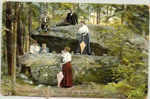
When you are a geologist you have to get used to the idea that you are always (pardon this!) a stone’s throw away from a journey into the distant past. We had such an experience recently at Lakefront Park in Cooperstown. There, at the end of the Pioneer Street, are eight sizable boulders. We imagine they are there to keep people from driving into the lake. But they helped us to “drive” into the early Devonian time period. That’s a journey back in time of about 400 million years.

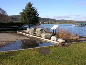
These boulders aren’t from the area; they were quarried somewhere else, but we recognized them immediately. They are from something that geologists call the Helderberg Limestone. They may well be from the Helderberg Mountains near Albany.
Limestones are special rocks for geologists. They carry us off to tropical places, and we mean that quite literally. The material of limestone is called calcium carbonate, stuff that mostly forms in shallow tropical seas. Have you walked the pink sandy beaches of Florida or the Bahamas? Then you have walked on carbonates. Petrify one of those beaches and, presto: sediment becomes rock, and the rock is limestone.
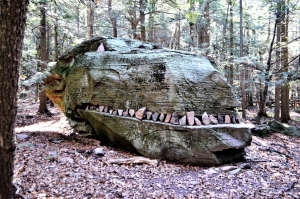
These boulders, however, did not form on some ancient beach. If you get a chance, take a good look at them. They are stratified, that is to say that the rock is layered. Each horizon represents a Devonian sea floor. We found some sandy sea floors and some muddy ones too. This was a mixed marine ecology.
There were plenty of creatures living on these sea bottoms. The boulders are all fossiliferous; look them over, and it won’t take very long for you to find some of these fossils. A visit here is a very colorful journey to the bottom of the sea.
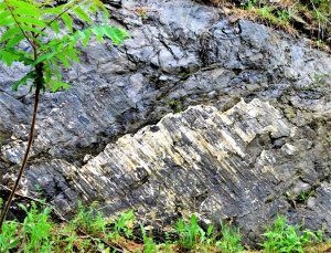
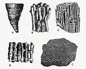
It was the corals that most caught our eyes. Yes, we said corals, and right here in upstate New York! Take a look at the fifth boulder from the right (east) side, especially on the right side of the rock, about two feet from it’s top. Our field notes tell us that there are two types of corals to be seen here. The first is called the honeycomb coral (C on second illustration) and that’s a good choice in terms. It looks like petrified bee’s wax. The second is the horn coral (A on second illustration). It’s called that because it looks like a cow’s horn, wide and round at the top and tapering to a point. You will see something that looks like the cross section of a cut orange. Horn corals have compartments that remind me of the segments of an orange.

There are enough corals here so that we have to wonder if these rocks did not come from a reef ecology. That could be, as the Devonian was a time of many large reefs and there are many Helderberg coral reefs known in New York State.
The story gets better when you learn more about Helderberg stratigraphy. As we said earlier, these limestones are exposed in the Helderberg Mountains. But the limestone strata are known to plunge underground as you head west towards Cooperstown. That means that some of the Helderberg lies buried deep beneath Cooperstown. Hundreds of feet beneath Lakefront Park is a great thickness of Helderberg Limestone and a good bit of it is probably fossil reef.
That means (and this is astonishing) that Cooperstown was certainly once the site of a beautiful shallow Bahamas-like tropical sea. Look around you and imagine the pink sands and green seaweeds that were once right here. Look up and see aqua colored waters above you. Imagine the primitive fish that once swam here.
And it only gets better, the more you think about it. Cooperstown is also very likely to have been the site of a Devonian coral reef. This is a pretty area, especially in the autumn, but have you ever, in your wildest imagination, envisioned coral reefs and all their beauty . . . right here?
Geology changes your perspective on things, doesn’t it?

Contact the authors at randjtitus@prodigy.net. Join their facebook page “The Catskill Geologist.”

Erratic behavior – Alligator Rock 10-24-9

in Uncategorized by

Erratic Behavior
On the Rocks
The Woodstock Times, 1997
Updated by Robert and Johanna Titus

North Lake Campground has always been a wonderful place to visit at any time of the year, but autumn is a special time. We never need too many excuses to make the trip. We almost always start out at the parking lot at North Lake itself, then we take the trail south along the shore of the lake. The trail will take you out to the point of rock that separates North and South Lakes. Travel around the point and in another quarter mile or so you will encounter a most remarkable boulder. It is enormous, it must be twenty-five feet or more across and perhaps eight feet high. That’s a lot of rock, but that’s not all.

A rock that big deserves a name and this one is called “Alligator rock.” We are not convinced that was a good choice, how about dinosaur rock? Nope, that name has already been taken for an equally large boulder about 50 yards away. But we don’t get to change names anyway: Alligator rock it is.

A person is entitled to ask where a boulder this large came from. It’s a good question and there is an answer. Boulder rock is what geologists called a glacial erratic. About 15,000 years ago all of North Lake was buried under a large glacier, a sheet of ice that was flowing southward down the Hudson Valley.
Moving ice is good at two special things. First it is very good at ripping up large blocks of rock and second it is even better at carrying those blocks of rock away. You have to use your imagination to get a fix on all this. Travel back to the Catskill Mountain House ledge and gaze at the horizon to the north. You have to be able to see ice coming down the valley and slowly filling the Hudson. Then it rises up the highest slopes of the valley wall right beneath us. Soon ice is coming over the ledge just to the north. The ledge is soon overwhelmed by the moving ice. As the glacier shears across those barriers of rock it adheres to the rock and plucks loose many large boulders.
Nobody can actually see such a thing. You really do need a good imagination to imagine all this. In real ice age life such events go on in the darkness at the bottom of a glacier. But we understand that the bottom of every moving glacier is replete with many such boulders. Some of them are a lot bigger than Boulder rock. Some are truly the size of houses. Neither Alligator nor Dinosaur Rocks are that large, but they are big enough.

Contact the authors at randjtitus@proigy.net. Join their facebook page “The Catskill Geologist.”

Boulders at Mink Hollow 10-17-19

in Uncategorized by

Boulders of Mink Hollow
On the Rocks\
The Woodstock Times
Updated by Robert and Johanna Titus

If you live in Woodstock, then one of the most accessible of the Catskill hiking trails is the one at Mink Hollow. Head west on Rte. 212 and then, just past Cooper Lake, turn north on Mink Hollow Road. At the end of the road you will find parking and the trail head. Soon you can begin your hike on the Blue Trail. The hike will take you up what was once actually a highway of some importance. Vehicles, loaded with people and goods from as far away as Prattsville, traveled on it with destinations in Woodstock and beyond. There are still paved Mink Hollow Roads both north and south, but here in between, the trail stopped being a public road long ago. Today the path takes you up to Mink Hollow itself. That’s a deep, narrow gap in the mountains, mostly cut during the Ice Age. Beyond Mink Hollow the trail veers off to the northeast and takes you along Roaring Kill to another trail head on Elka Park Road. It’s an easy walk through the woods, and that’s especially nice in the summer. It stops being easy if you want to climb Sugarloaf or Plateau Mountains. Those are tough climbs, but well worth the effort. They are, however, another story for another day.
There is one very nice geological feature to see here, however, and that is our subject for today. In Mink Hollow itself there is a lean-to, built to give hikers a place to spend the night. Just south of this lean-to there is a wonderful example of what glacial geologists call pedestal rocks. You can’t miss them. They are immediately east of the trail, just about 100 yards short of the lean-to. They make a most striking feature. There are three good-sized boulders. Two of them are next to each at the bottom of the heap, while the third is a cross bar, lying atop the others and bridging the two.


Just how on earth could such natural Stonehenge happen? First of all, nobody stacked them here; there were never any Druids in the Catskills and the boulders are far too large and isolated for any other people to have bothered with them. There are some who think that such things were human in origin. But we think there is a natural explanation. Nature did this, and geologists long ago figured out how. Our story takes us back to the end of the Ice Age. At that time, probably about 16,000 years ago, there was a large glacier, filling all of the Schoharie Creek Valley to the north. A large tongue of that glacier poked through Mink Hollow and pushed on a short distance to the south.
This was a dynamic tongue of ice and it was actively advancing through Mink Hollow. If the leaves are not too thick, you can look upward from the lean-to and see a number of rough ledges on the western slope of Sugarloaf Mountain. These formed when large masses of rock were plucked from the mountain by the moving ice. And that gets us to the heart of our story.
That huge tongue of ice passing through Mink Hollow had a great number of boulders in it. These were routinely being broken loose from the ledges above and carried through the hollow. Most were dragged off to the south by the currents of moving ice and deposited at the south end of the glacier.
But eventually the climate warmed and the glaciers began melting. At that time blocks of rock would have been lowered through the melting ice until they made a soft “landing.” As luck would have it, some boulders would land next to each other, while on much rarer occasions, a boulder would end up lowered onto one or two others, forming a pedestal. That’s what happened along the Mink Hollow Trail.
Pause here for a moment and imagine Mink Hollow filled with ice. Look around and you will see all the boulders that are here. Each one was once the baggage of a glacier. It’s a nice story and just one of those many interesting phenomena that remind us of the influence glaciers have had on our landscape. And it is nice not only to appreciate the beauty of a landscape, but to understand it as well.

Contact the authors at randjtitus@prodigy.net. Join their facebook page at “The Catskill Geologist.”

The Old Mountain Turnpike 10-10-19

in Uncategorized by

The Old Mountain Turnpike
The Greenville Press
Sep. 4, 2007
Updated by Robert and Johanna Titus

One of our region’s most historic roads is also one of its least known. It’s the Old Mountain Turnpike. Long ago, the road was the gateway to the Catskills. As far back as the 1820’s guests of the famed Catskill Mountain House Hotel rode carriages up the road to get to the hotel. As the Mountain House prospered, so did the road. When the hotel got too successful it built the Otis Elevated Railway right up the Catskill Front and the turnpike fell into disuse. Today the old road is just a horse and hiking trail, but it still has much of its 19th Century atmosphere. It makes a nice walk in the woods and, of course, along the way there are many rocks.
To get to the old turnpike take Rte. 32 south to the turn at Game Farm Road. Soon you must turn left onto Boggart Road and head south to a right on Mountain Turnpike Road. The trail head is at the end of the road. You can hike all the way up to North Lake State Park if you like, or any part of the trip.
You don’t have to go far before you are in the thick of the geology. The road makes a bend to the right and alongside is an outcropping of red rock. The rocks are floodplain deposits of the Devonian age Catskill Delta. Red strata are old flood deposits, silts and clays deposited by very long-ago floods and hardened into red shale. The darker deposits are the old muds of back swamps. Away from the river channels swamps formed in low-lying areas and dark muds accumulated. Watch for fossil plant fragments in all of this.
As you continue up the road you will encounter, at frequent intervals, a number of sandstone ledges. These are first seen in the slopes above the road, and, as the road rises, the ledges descend to its level. The sandstones are old river channel deposits. They are composed mostly of sandy strata that dip one way or another. These are called cross beds and they are the product of river currents. The currents drove masses of sand into large “dunes” which migrated downstream. Most of those cross beds dip to the northwest as that was the direction that the rivers flowed. In between the sandstone ledges the road tends to be pink or red. These are hidden floodplain deposits. The pattern is clear: River sands are followed by red floodplain shales and then more river sands and so on. The Catskill Front is made up of sandstone and shale “stories” of stone, like a great, tall building. When we make such a hike, we almost always count the stories.
The second story had some prominent ripple marks in a layer of red shale that crossed the road. This recorded Devonian breezes that blew across a shallow floodplain pond and generated currents that, in turn, created the ripples. Those ripples were a recording of a breeze of about 375 million years ago. It is incredible to think of.

At the fourth story we found a vertical ledge of sandstone that had been scoured and striated by a passing glacier. This event had occurred a mere 14,000 years ago, a twinkling of time compared to the age of the rocks themselves.
The 14th story was particularly massive sandstone. This must have been a very large river. These rivers were what are called distributaries. In a large delta complex the trunk stream breaks up into many such distributaries. Each one flows into the ocean. Look at a map of the Mississippi Delta and you will see good examples of distributaries. Better still, look at a map of the Ganges River Delta of Bangladesh and you will see a better example.

The road ascended into a hollow and made a sharp bend. Here had once stood the Rip Van Winkle House; it had been the halfway stop for carriages headed up to the hotel. The hollow was naturally air conditioned with cool heavy mountain breezes descending through it. It must have been a nice place to stop.

Just ahead was one of the largest, thickest stories of the hike. We thought that this must have been one of the greatest rivers of the Catskill Delta. These distributaries meander back and forth across a delta plain. A river that is here today, may be gone tomorrow, replaced by a floodplain. That’s why these rivers sandstones alternate with red floodplain shales. The geology here is actually very easy; the sandstones are river deposits and all the rest is floodplain. Everything is Devonian and none of it is less the 350 million years old.
The 24th story brought us to a great overlook. The trees have been cleared away here and a picnic table set up. We interrupted our journey and sat and gazed out at the Hudson Valley. We had seen a lot of geological history already. We had watched as 24 times rivers had crossed this location back in the days of the Catskill Delta. Much of this had been sandstone and sandstone is made of sand. But where had all that sand come from? The only place such large amounts of sand can come from is the erosion of a great mountain range. From our picnic table seat, we gazed across the Hudson Valley and saw the profile of a great mountain range rising above the Berkshires. These were the Devonian age Acadian Mountains. They may once have rivaled the Himalayas, but now they have been eroded away. All that is left are those picturesque hills of western New England. Now we really had seen a lot of history, but there was so much more.

The old trail and we continued up the mountain in a zigzagging pattern. Sometimes the way was very steep, and we thought of how the horses must have struggled here in the 19th century. The sandstones came to be much thicker and prominent. Very large ledges lay left and right of the old path. The road cut right through some of them in several locations. Now we understood what they represented. These sandstones were a record of the destruction of the Acadians. As the old mountains came to be weathered and eroded, they shed their sands into New York State and made the sediments that would eventually become the Catskills. And the Old Mountain Turnpike was a history of all this.
Close to the top of the Catskill Front the old highway levels out. The horses must have been relieved, they had had a very hard haul up the mountain and now they had a little rest. But there was one more sharp turn. In the 19th century, that turn had brought travelers to within a short distance of the Catskill Mountain House hotel, but then it took them away. The highway had to climb one more great ledge and it zigzagged in order to manage that. That last ledge is the thick one that makes up the crest of the Catskill Front. It is the grand ledge that the old hotel stood on itself.

When we finally reached the top, we visited the hotel site and sat and gazed into the Hudson Valley. It had been quite a hike and we had passed through a lot of history. Before us was that ghost image of the old Acadian Mountains. As we pondered it all we realized that there was some pretty strange geology here. We were sitting upon the sandstones of the Catskills that, themselves, were made of sands from the Acadians. The death of one mountain range had given birth to another. Nature does wondrous things.

Contact the authors at randjtitus@prodigy.net. Join their facebook page “The Catskill Geologist.’

The Ghost Mountains – Devonian Pt. 14 – 10-3-19

in Uncategorized by

Ghost Mountains
The Devonian Part 14
The Greenville Press
Oct. 26, 2006

We have made a long journey through time. Last summer [2005] we started out along the highway in Leeds and visited the Helderberg Limestone there. Through 13 chapters we have traveled through a thick sequence of thousands of feet of Devonian age strata. Most of those are exposed along Rte. 23 and most of those are sandstones. All of these rocks were once sediments, mixtures of sand, silt and clay. Geologists have long recognized that thick sequences of sediment must have taken very long periods of time to accumulate. Our sedimentary sequence is estimated to have needed 50 million years or so to form.
But there is a second question. Where did all that sediment come from? Thousands of feet of sand a mud must have come from somewhere and it must have been somewhere very big, but where? The answer to that question takes us across the Hudson River and into the Berkshires. If you make this trip you will soon find very different sorts of rocks there. Visit Bash Bish Falls, in Columbia County, sometime and you will see rocks that are not sedimentary. Instead of being composed of sedimentary material, the rocks there are crystalline. We call this stuff gneiss and it formed deep within the crust of the Earth. There enormous temperatures and pressures “cooked” the rock and in that setting all the crystals were able to form. The marvelous thing about the Bash Bish Falls rocks are that they take us not only far back into time but also into the deep depths of the Earth’s crust. We are looking at rocks that formed many thousands, even tens of thousands of feet down.

We are looking at the bowels of an ancient mountain range. We have mentioned those mountains a number of times in past columns; they were the Acadian Mountains. The Acadians were an early version of the Appalachians. They began to form nearly 400 million years ago when a continent we would call Europe today drifted westward and began to collide with North America. The collision is duplicated today in Asia where India is Colliding with Tibet. The result is the great Himalayan Mountain chain. These are the highest mountains on Earth. The Acadians were very possibly just as tall.
Gaze eastward on the horizon and, in your mind’s eye, see the mountains that once were there. Their snow packed peaks are thought to have reached elevations of about 30 thousand feet. That means Bash Bish Falls and its rocks were once about five miles beneath the tops of those peaks. Climb to the top of Mt. Everest someday and then look down five miles into the earth and, presto, you understand Bash Bish Falls a lot better.
Here in Greene County we can’t see any crystalline rocks, but we can look into the depths of the Acadians. A record of those mountains is found along many of our area’s roadside outcroppings. Take a ride east on Rte. 23 to the famed outcrop on the off ramp that leads to Leeds. The rocks here display the deformations that come with two periods of mountain building. The strata stretching off to the left are Devonian in age. They dip steeply to the left. These strata were deposited as flat sheets on the bottom of the ancient sea floor. But now they are nearly vertical. What happened? They were affected by the deformation of the Acadian Mountain building event. As Europe collided with North America the crust here was lifted and crumpled. The strata were tilted steeply their original horizontality.

On the right side of the outcrop are even older rocks, dating back to the Ordovician Period, about 450 million years ago. These rocks were tilted twice. First, they were involved in a mountain building event called the Taconic Orogeny. Later they came to be tilted by the Acadian Orogeny. If you are an old sequence of strata then, eventually, you will become involved in multiple mountain building events. That’s why the angles of dip for the older and younger rocks are different. Two angles of dip – two mountain building events; it’s as simple as that.
If you continue down the off ramp and turn right, you will see a long low cliff across the road. There’s more mountain building to see there. The rocks of that cliff have been fractured. The fractures are nearly vertical and there are a lot of them. There has been some movement of the rocks along those fractures and so, technically, they are geological faults. You won’t confuse these with the San Andreas Fault; these never caused too much commotion. But you can see evidence of the motions. Some of the vertical fractures have coatings of the white mineral calcite on them. If you look very carefully you will see that the calcite has been striated. Striations are delicate scratches etched into the minerals during the motion. The blocks on each side of the fracture moved past each other and that caused the scratching. Once you have developed an eye for this you will find a lot of striations. Geologists call these slickensides.

If you return to Rte. 23 and head west, you will find more excellent cliffs of limestone. Stop from time to time along the fine cliffs here, you will soon see more evidence of mountain building deformation. A short distance down the road the strata are not only tilted, but they are folded as well. Watch the rocks carefully and you will large sweeping folds in some locations and tight complex folding elsewhere. It is a most remarkable thing to first observe folded rocks. After all, rock is pretty brittle stuff. Have you ever even thought of bending a rock?
The folds we see here are a testament to the enormous powers that are generated deep with the crust of the earth. Down there, the rocks have been heated to extraordinary temperatures and their deep burial has subjected the rocks to enormous pressures. Under these two circumstances, folding becomes a very plausible, indeed mandatory phenomenon.
But these rocks are not deeply buried within the earth’s crust; they are right at the surface. And that is the whole point. We are privileged to be looking deep into the earth’s crust while standing on its surface. How can that be? The answer is simple: the rocks that we see in Leeds were once buried under thousands of feet of other thick strata. That was hundreds of millions of years ago. And since that time weathering and erosion have been destroying the overlying rocks, the “overburden,” until nowadays what was once buried is now exposed. It is a remarkable thing but at Leeds we are indeed peering into the bowels of the Earth.

Contact the authors at randjtitus@prodigy.net. Join their facebook page “The Catskill Geologist.”

Go to Top