"I will never kick a rock"

Monthly archive

January 2019

Juxtaposition Jan 31, 2019

in Uncategorized by

On The Rocks
Dec. 6, 2007
Updated by Robert and Johanna Titus

Geologists are generally very good at spatial relations. There must be some lobe in the brain that functions to give us a special edge in that facility. We need it; we are always envisioning the many complex geological structures that we come across. But there is more; there is, after all, a fourth dimension and that’s where geologists are very, very good. Come along and see.
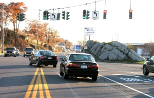
Let’s take Rt. 9W down to the malls, just north of Kingston. You might not think this would be an attractive field trip site for a geologist, but you just might be wrong. At the south end of the malls, just across from the Red Lobster, the road forks. We were down there on Black Friday and soon we found ourselves, armed with a camera, risking our lives for you the readers of the Woodstock Times.
Black Friday is certainly quite a moment in time. Hoards of avaricious shoppers descend upon all those retail outlets, determined to begin their annual rites of Christmas shopping. The highways are crammed with traffic and that is where we found ourselves. We stood, precariously perched on a supposedly safe set of double orange lines, with traffic streaming by on both sides. Oblivious to our near certain doom we looked south: and into the deep geological past.
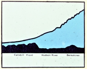
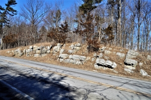
Just where the highway forks, between the two lanes, is a very fine outcropping. Beyond, and off to the left, was another equally impressive ledge of rock. These were exposures of the Helderberg Limestone, one of the most important units of rock in the area. We said we were looking into the past, and what we saw there was the Helderberg Sea.

Back, just a little more than 400 million years ago, during the Devonian time period, this was a very different place. There were no malls and no highways back then. What there was here was ocean. This Helderberg Sea was a very shallow, very tropical sea. Today you would have to visit the Bahamas or west Florida to find something akin to this.
But we were not in the Bahamas and we were not even of this time. For us, it was the Devonian and we were gazing across the shining, aqua-colored waters of the Helderberg Sea. Its shallow seafloor was visible from above. We looked down and saw just a few strange shellfish and fronds of algae waving in the active marine currents. The sediment was composed of calcium carbonate, a mineral those plants and animals secreted.
That sediment long ago hardened into limestone and that is the rock exposed across from today’s Red Lobster. We were back in the present, and noisy Black Friday traffic streamed by us. We had the presence of mind to shoot a couple of photos. Then we noticed something about the stratification; it was tilted, with the beds of rock inclined to our right. The same was the case with that second outcrop, just a little farther down the road. Then we were swallowed up into the past once again, this time it was to a different past.
All around us was total darkness, but we could see, we just don’t know how. We were still in exactly the same place where we started our journey, but there was no highway and, of course, no orange stripes. In the spooky darkness before us we could make out the very same inclined bedding we had just been looking at. But now, each of those strata continued upwards, rising far above us. We had traveled forward through time about a hundred million years. The Helderberg Sea was long gone. It had been buried in a mile-thick accumulation of sediment, mostly sand. Then all those sediments had hardened into rock and the whole sequence had been uplifted and tilted.
Above us, for a mile or so, was the bedrock mass of a great mountain range, called the Acadian Mountains. Most of its highest peaks were off to the east in what is now New England. That’s where most of the uplift and folding had occurred, but the deformation in front of us was nothing to sneer at. We were now deep inside a still rising mountain range. It was very much as if we were a mile beneath the surface of today’s Nepal with the high peaks of the Himalayas nearby.
Now we noticed the heat and the intense pressure that comes with burial at such depths. There were some occasional groaning sounds; deformation of the rocks was ongoing. All this could do us no harm for, on this journey, we were the mind’s eyes, and little harm can befall the human imagination.
But living bodies can be run over by cars. We found ourselves back on the orange stripes of Rt. 9W on that busy Black Friday. We took one more photo and scrambled off the highway, still in one piece. Our journey was a fine exercise in spatial and temporal relations; we had seen the Kingston malls of today and we visited the same sites in moments of their distant past. It’s all the same, kind of. We geologists are good at this sort of thing.
****************************************************************************************************
Contact the authors at randjtitus@prodigy.net. Join their facebook page “The Catskill Geologist.com.

Can you fold a rock? Jan. 24, 2019

in Uncategorized by

Can you fold a rock?
Windows Through Time
Updated by Robert and Johanna Titus
Register Star papers
March 22, 2012

Sometimes we geologists are just as dangerous as bird watchers. Bird watchers are notoriously bad drivers. They will be sailing down the highway when, all of a sudden, some marvelous bird goes flying by. Cross your fingers if you happen to be driving nearby. And, if you are a birder, don’t write us to deny it; we know better!
Well, as we said, we geologists can be just as bad. We too, can be sailing down the highway when, all of a sudden, there is some marvelous outcropping of rock: something we never expected to see. Watch out, we are liable to hit the brakes and come to a screeching halt, with you screeching too.
Well, you can probably see where we are going on this. Recently, we were on driving on Tarrytown Road, off Rt. 32, on our way to a lecture up at the Thacher Nature Center. Just after the road makes a sharp right turn, there was an absolutely beautiful folded mass of rock. This was stratified rock and, specifically, limestone.
Did we say “folded rocks?” We think we did. If you are not a practicing geologist, that may seem like an unlikely notion. How on earth do you fold rocks? Take a look at our photo and see for yourself. It shows the outcropping that we saw. The strata are from the Helderberg Limestone and there they are, folded into a broad curve, an upside down U. Geologists see such folds a lot; we call them “anticlines.”


It must stretch a good 50 feet from end to end. And it must rise up ten feet or so. But how can such a thing happen? Go find the strongest man you know and give him a rock and ask him to fold it. There is not a chance that he can do that, not even with a small thin rock. But there it is, a great mass of folded stratified rock.
We wonder what professional geologists thought of all this, centuries ago when the science was young. They could not have had any ideas, none at all. It must have been such a mystery. That happens a lot in science, right up to this day. We see a phenomenon and we just can’t explain it.
But geology is not a young science; it is a venerable old one. We have been solving our problems for a very long time now and we can explain a lot of them. So, how did these folds occur? The best answer involves the science of plate tectonics. That was the great revolution in geological thought that occurred in the middle 20th Century. We now know that continents and subcontinents can move across the surface of the Earth. North America is sliding west, right now and beneath your feet. It’s very slow so you can never feel the motion, but it is happening.
Starting during the Devonian time period, about 400 million years ago, a landmass named Avalonia was moving westward across an early version of the Atlantic Ocean, sometimes called the Proto-Atlantic. Avalonia eventually collided with North America and that generated a lot of pressure. The stratified rocks of North America came to be squeezed. You can simulate this with a large paperback book. Hold it in your two hands and press. The book will fold, quite likely into an anticline. One hand is North America while the other is Avalonia. It’s a nice easy lab experiment; you are doing science. Well, that is was happened to the strata along the highway.
But our problems are not all solved. We didn’t hit the brakes because we had seen a fold. We hit the brakes because of which rocks were folded. You see, the problem is that there are no other folded rocks in this vicinity. There are lots of outcrops of the Helderberg Limestone all around, but none of them are folded. These strata lie just a little too far to the west to have been folded by the effects of a colliding Avalonia. You can go see this for yourself. Just wander the highways around there and see what you can find. The answer is nothing but flat lying rocks.
We must say that we are flummoxed by all this. How could it be? A lovely anticlinal fold just seems to rise up out of the ground without a proper explanation. We may be flummoxed, but not bothered all that much. In truth, it is nice to still have mysteries. We don’t envy geologists or other scientists of the future. They will have so many fewer problems and mysteries to go out and solve. Or will they? That’s debatable. But we do have problems. We are blessed with lots of them.

++++++++++++++++++++++++++++++++++++++++++++++++++++++++++++++++++++++++++++
Contact the authors at randjtitus@prodigy.net. Join their facebook page “The Catskill Geologist.”

Closely shaved rocks Jan. 17, 2019

in Uncategorized by

Getting a Close Shave
On the Rocks
Updated by Robert and Johanna Titus

Rockcraft 101 – the Shaved Rock – We occasionally write about a mythical field we call “rockcraft.” There’s really no such thing or the Boy Scouts would have a merit badge and a handbook about it. But if there were a field of rockcraft it could keep an outdoorsman quite busy. Rockcraft would be the use of signs found in rocks to guide you in the woods. Believe us, glaciers would be responsible for a great deal of rockcraft.
Think about what a major glaciation amounts to. In this vicinity, for example, at about 20,000 years ago, there was a sheet of ice about a half mile thick. Imagine the weight of all the ice. Not only is the pressure of that weight bearing down upon the underlying countryside, but there is the frictional drag which comes with the southward movement of the ice sheet. That’s a lot of stress.
It gets worse. The bottom of a glacier is, to say the least, dirty. There is a great deal of silt and sand down there. Also, there are likely to be many cobbles and boulders being dragged along. And all of this material is pressed onto the underlying countryside. It’s no surprise to find out that a passing glacier leaves a lot of evidence behind.

  shaved off rock

There are a lot of glacial phenomena that we like to watch for. One of them doesn’t even have an official scientific name that we have even seen. So, we just call it “shaved off rocks.” This is what happened. Here in the Catskills there are a large number of sedimentary rocks that are rich in small and large cobbles. The rest of the rock is usually a sandstone, so imagine cobbles floating in a matrix of sandstone. When a glaciation occurs, it is normal for a bedrock to become ground down by the sand and silt in the passing ice. The behavior is exactly like what you get with sandpaper, only this process is much more effective; it can grind away inches of solid rock.
When a glacier is grinding away at a sandstone it is eventually liable to encounter some of those cobbles we mentioned. These may become popped out by the moving ice, but they are more likely to be held in place as they are well cemented into the rock. That means that the grinding process will begin to bevel right through the cobbles and shave off their tops. What’s left behind is half a cobble with the top planed off to a flat surface.
That leaves a very distinctive rock outcropping, a sandstone surface with the beveled off cross sections of cobbles upon it. A good place to go and look at such rocks is along the escarpment trail, right at the edge of the Catskill Front. Your best chances of seeing these are at North Lake State Park, just north and south of the lake itself. We have seen some very nice beveled off rocks immediately south of Boulder Rock and also up on Newman’s Ledge (Park maps will guide you to these sites). If you find either of these locations try to imagine the thick sheet of ice that was once here. Then remember that the ice filled up the entire Hudson Valley below.
If there is anything bad about these shaved rocks, it’s that usually you cannot tell which way the ice was moving. That’s not always the case. When the ice was relatively thin, it did not press down as much. Under those circumstances a solid quartz cobble might put up enough fight to resist the beveling at least to a certain extend. That’s when you get something called a “rat’s tail.” A vee-shaped cone of sandstone lays on the protected downstream side behind the cobble and is sculpted by the passing ice. The protected cone points in the direction of flow. We found one of those on the point of rock between North and South Lakes.
Our field of rockcraft is rarely about very important phenomena. It’s, instead, a field devoted to recognizing interesting things in the rocks. Shaved rocks are not terrible important, except as testimonies to the erosive power of a glacier. That’s good enough.
===================================================================
Contact the authors at randjtitus@prodigy.net. Join their facebook page at “The Catskill Geologist.” Read their blogs at “thecatskillgeologist.”

The Old earth Jan. 10, 2019

in Uncategorized by

A very old story
Stories in Stone – The Columbia County Independent
Nov. 23, 2007
Robert Titus

Before I was lured away by the fame and fortune of writing geology columns, I was a professional paleontologist. I published many an article on the ancient life of New York State in professional journals. I speak of this because my science is and has been under assault. The centerpiece of paleontology, like all biology itself, is the great theory of evolution. All of my professional research was founded upon evolutionary theory and the best studies that I ever did myself were documentations of evolutionary events.
I have, three times, followed a fossil species through sequences of stratified rock and watched as it evolved into a second species. I have not only seen species evolve but I have followed them as they evolved into new ecologies. These studies were among the greatest privileges that ever came with my being a scientist. I have seen evolution about as well as anyone, anywhere. That’s not bragging; it’s just the record.

Paleontology is the exploration of life’s distant past. It is nearly heartbreaking that some religious groups oppose my science’s very foundation. Science is not about religion; we steer well clear of the supernatural; ours is the study of the natural world only. We neither oppose, nor support any religion. Some of us practice religions; others, like me, do not.

But we do teach our sciences. Ours is a scientific and technologically advanced society in a competitive world, and it must maintain the highest standards in the teaching of science. There is no place for, say, economics or politics to play a role in classroom science. Likewise, this is no place for any religion to intrude its views. Such notions should be dismissed immediately. Economists and political scientists generally don’t interfere with the teaching of science, but there are members of the religious community would if they could.
Young Earth “Creation Science” and its fraternal twin “Intelligent Design” profess that a great supernatural entity (God) created the world and all life on it. Well, fine, many scientists are religious and believe the very same thing. Where science and these particular religious views part company is over the issue of evolution. Was the Earth and life on it created as we see them today, or did they form and then change naturally? Did life change slowly through time, evolving from a simple ancestral form into what it is today?
In recent years serious efforts have been made in Pennsylvania and Kansas to inject Intelligent Design into high school biology programs. I hate to think of the position that many dedicated biology teachers might find themselves in. Should they risk their careers in defiance of religion? Or should they knuckle under? It is a dreadful dilemma.

All this has been portrayed as part of the ongoing “culture wars” but I disagree. Issues like abortion, school prayer and displays of the Ten Commandments and manger scenes are value issues. People of good conscience can come to different views. But science has, I would hope, always fallen beyond that. We study the natural world as it is, not as we want it to be. We scientists have always determined to steer clear of values as much as possible

This column has found a very considerable body of evidence that, like the rest of the planet Earth, our Hudson Valley has a very venerable geological history. We have, over the last few years, taken many trips into our region’s distant past. We have visited the great deep oceanic abyss that once covered all of Columbia County. Its dark oozy mud is now hardened into the black Normanskill Shale which makes up much of the land along the Hudson. We have also visited the shallow tropical sea that once existed here. Its Helderberg limestones make up all of Becraft Mountain and they are rich in an exotic array of fossils. All those fossil species are now extinct; they were denizens of distant past. At Bash Bish Falls we have watched as great mountains rose to enormous altitudes in what would eventually be the Appalachian realm. Then we saw those mountains slowly weather away. We’ve seen glaciers advance down the Hudson Valley and, after they melted away, we saw Glacial Lake Albany fill most of our valley with icy meltwater. Altogether these historic events took enormous lengths of time: hundreds of millions of years.

If either Creationism or Intelligent Design is true, then all of this geological history is horribly misconstrued at best, fraudulent at worst. I and all of my colleagues are seriously deluded people. Can that be? I have always tried to tell where you can go and see the evidence for yourself. I hope that many of you have done some of the many field trips that I have described. If so, you can judge for yourself. Our valley and our Earth are very old.

——————————————————————————————————————————————-
If Creationism or Intelligent Design is true, then science itself is a hoax. Well, keep reading my columns and judge for yourself.
Reach the author at titusr@hartwick.edu.

Geological history of the Hudson Valley

in Uncategorized by

The Hudson Valley: 400 years? Or 400 million?
Stories in Stone 2009
Updated by Robert and Johanna Titus

This year (2009) marks the 400th anniversary of Henry Hudson’s voyage up the Hudson River. This is a real landmark and there will be a large number of events commemorating Hudson’s historic journey, as well there should. We wonder what role geologists can play in all this? We have a way of turning up our noses at mere centuries, you know. Even a few million years is not all that impressive to us.
But, in fact, when it comes to cultural history, geologists have pretty much the same sense of time and antiquity as everyone else. We will be participating in at least one commemorative event in September. We will be speaking at the village of Stuyvesant, presenting a talk on the town’s geological history. We will also be writing up an ice age history for the town of Claverack.
But today, we would like to survey the geological history of the whole Hudson Valley. It has a venerable past and, of course, it dates back a lot more than 400 years. In fact, it appears to date back about 400 million years.
Now We had better issue a few caveats first. The history of any ancient river is always hidden in the mists of time. It is hard, really hard, to document the distant past of any river. You see, they do not preserve records of their earliest times. All rivers are in the business of eroding the landscape they flow across. That erosion destroys all evidences of their pasts. The earliest stages of development of a river’s history are worn away by the latter. We geologists have to summon up all of our powers of deduction to intuit the missing history. So, the story we will relate today does not carry the certainty of other geological tales. The evidence is just not there. Late at night, in geology bars, we happily debate this sort of thing.
As we said, this story, or this version of the story, begins roughly 400 million years ago. At that time New England was recovering from a great mountain building event: the Taconic Orogeny. Massive crustal uplift had created the earliest Taconic Mountains which, originally, towered over western New England and parts of New York State. But by 400 million years ago these mountains had, in fact, experienced a great deal of erosion and they were mere shadows of their former selves. But soon there would be another major mountain building event: the Acadian Orogeny. An even taller range of mountains came to rise above pretty much the same landscapes.
Today all these mountains have largely eroded away. We still have remnants of the Taconic’s, and the Berkshires hearken back to the much taller Acadians. The point of all this, is that the existence of these mountains would form an eastern barrier to any potential flow of rivers. If you look around eastern New York State, and all of Connecticut, Massachusetts and Vermont you will not see any significant west-to-east flowing streams. No such streams have existed for at least 400 million years.
Erosion of these long-ago Acadian Mountains produced vast quantities of quartz sand that eventually hardened into the bedrock of today’s Catskill Mountains. Originally, these sedimentary rocks piled up right against the Taconic’s and there was, at first, no room for an early Hudson Valley. These sandstones were very rugged stuff and they formed a barrier to any streamflow. Thus, there are no east-to-west flowing streams passing into and then beyond the Catskills.
But rivers, large and small, must have descended down the western slopes of the Taconic’s and when they approached the Catskills they had a problem. Which way would they flow? They couldn’t return back uphill to the east and they couldn’t advance into the Catskills either. That left north or south; they turned south and flowed toward the Atlantic. That first such flow marked the origin of the ancestral Hudson River. It assumed much of its current path, flowing north to south and on into the Atlantic.
There was more to come. During the late Jurassic, about 150 million years or so, the crust of the lower Hudson Valley rose, forcing the Hudson to carve a canyon through what are today the Hudson Highlands. With that, much that we recognize, today, as the Hudson Valley came into existence.

Profiles of Ancient Acadian Mountains and modern Hudson Valley

Is this the true story? We don’t know; it is a good one, but much debate remains. Maybe someday we will have a better version. But, until then, this yarn has a lot to recommend it. The next time you find yourself out in the middle of the Hudson Valley, look east to the Taconic’s, and then west to the Catskills. At first there had just been a small crease here, lying between the two highlands. Appreciate that for hundreds of millions of years the Hudson has been slowly widening and deepening this crease, turning it into our great Hudson Valley.
=============================================================
Contact the authors at randjtitus@prodigy.net. Join their facebook page “The Catskill Geologist.”

Go to Top