"I will never kick a rock"

Monthly archive

September 2018

Sam’s Point Sep, 27, 2018

in Uncategorized by

Glaciers at Sam’s Point
On the rocks
Robert and Johanna Titus
Woodstock Times
Sept. 19, 2013

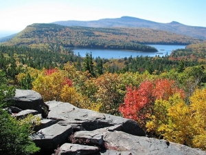
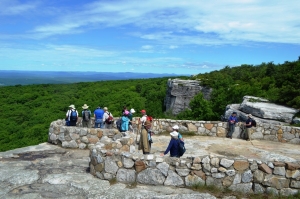
The Shawangunk Mountains are certainly one of the most scenic locations in our region, and uniquely so. The Ridge of resistant quartz sandstone towers above the Hudson Valley and offers numerous views of that landscape. One of the most popular locations is Sam’s Point Preserve, near Ellenville on the south end of the mountains. It is a sizable nature preserve with 4,600 acres of land, most of it perched at the top of the mountains at elevations well above 2,000 feet. It’s owned by the Open Space Institute and managed by the Nature Conservancy.
Today this area is valued as a scenic preserve but, in the past, there were commercial uses. The mountaintop here has abundant blueberries and it used to be that people were hired every summer to come here and pick them. Then, in addition, there were several resort hotels; it was, after all an ideal vacation destination.
But we came here to learn about the geology. How had the area’s geological history given rise to this scenic wonder? We came early on a Saturday so that there would still be spaces in the parking lot. We toured the museum, but not for long; our hearts were in climbing atop the mountain. We headed up the trail.


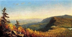
It didn’t take long to figure out why the Shawangunks are there. All along the trail were massive outcrops of quartz sandstone and conglomerate. Quartz is very resistant to weathering and a mountain made out of quartz sandstone will stand out as all other bedrock around it erodes away. The “Gunks” are Silurian in age; that makes them perhaps 420 million years old. Way back then there must have been some sort of coastal plain composed of quartz sand. That would have been similar to our eastern North American coastal plain of modern times. The conglomerates are composed of quartz sand mixed with quartz pebbles. If anything, they are an even more resistant form of rock.

We got up to Sam’s Point itself and soon learned much more about the geological history that went into creating the mountains we see today. We arrived at the easternmost of two platforms, composed of bedrock and seemingly designed for sight-seeing. Naturally, we were more interested in looking down at the rock than gazing at the scenic views. It was, of course, more quartz sandstone, but there was something special that caught our eyes.
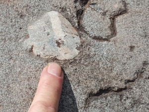
There was a polished sheen to the surface of the rock and there were faint striations cut into that surface. We quickly recognized these to be ice age features, common ones at that. Sam’s Point had a long ice age history. Probably going back to the time when glaciers first came down the Hudson Valley, and lasting until the last glacier melted, this site had ice flowing across it. The ice was dirty, carrying a great deal of sand along with it, mostly concentrated at its base. The sand, probably mixed with a lot of silt and clay, actually did polish the bedrock. It sanded it down and planed it off. The generations of people who passed before us had, with their footsteps, worn this down until it was not all that easy to see, but it was there to the trained eyes.
There was more. The glaciers carried with it a large number of cobbles and boulders. As these were dragged across the surface, they gouged scratches into the bedrock. We call these glacial striations. We have seen surfaces like this many, many times so it was hardly a great revelation, but it did speak clearly to us of the fact that there had been a sizable glacier here once. Then we saw more.
We looked up and there was the cliff that defines Sam’s Point. It is another natural platform of quartz sandstone but this one is bounded by a vertical cliff, a big one. Most people would enjoy it as a fine scenic overlook, but our eyes saw back into the ice age. Geologists call this sort of thing a scour and pluck topography. These are common and they are the products of the advance of a glacier. The Hudson Valley glacier advanced from the north and, as it crossed Sam’s Point, it scoured that platform at the top of the cliff. That’s the scour part. Then, as the ice continued south, it yanked enormous masses of rock loose and carried them off. That left a gaping scar in the mountaintop and that is the cliff of Sam’s Point. That is also the pluck part of this landscape.
The cliff faces a compass direction of south-30 degrees-west. That, presumably, was the direction the glacier was traveling. We looked at the striations beneath us, and we had a compass. They too were oriented south-30-west.
Now we had a nice coherent explanation for the topography of Sam’s Point, a real scientific theory to explain everything we saw there. It’s what scientists call an elegant solution to a problem. Everything in the explanation fits the evidence. We would have been flushed with pride at having made such a marvelous discovery were it not for the fact that, no doubt, thousands of other geologists had preceded us here, and had come to the very same conclusions.
==================================================================
Reach the authors at randjtitus@prodigy.net. Join their site “The Catskill Geologist” on Facebook.

Geology at Edna St. Vincent Millay’s Spindletop Sept, 20, 2018

in Uncategorized by

Through the Green forest
Poems in Stone
Robert Titus
Columbia County Independent 2007

My candle burns at both ends; it will not last the night; but ah, my foes, and oh, my friends – it gives a lovely light. Edna St. Vincent Millay, 1920

Many, perhaps most, poets are like Edna St. Vincent Millay; they celebrate, and even live, the quick passage and rapid burnout of life. But geologists are different; we appreciate the endless nature of time and the slowness of the changes that it brings. Geologists and poets are alike, however; they both seek out truths that lie just beneath the surface. My wife and I found this out when we visited Poetry Walk, just down the road from “Spindletop,” Millay’s home in Austerlitz.


The walk had originally been a farm path, carrying cows and firewood. Vincent (as she rather insisted upon being called) valued the walk for its bird sounds, birch grove and mountain laurels. It came to be even more spiritual when her mother Cora was buried there. Vincent and her husband Eugen Bossevain eventually joined Cora in repose at the end of the trail.
Our walk was a search for the truth beneath the surface. However it was not poetry but rocks that we sought out. As we entered onto the walk we found a cairn of rocks. Proudly placed at its top was a small boulder of pure quartz. It was a strange and beautiful rock and I soon noticed quite a few smaller versions lying along the path. I wondered about this odd lithology. Surely, just beneath my feet, the soils graded into quartz-rich bedrock but what was it? The quartz was associated with other rocks: shards of something called phyllite littered the path too. That’s a dark and thinly layered rock. Its laminations are shiny, folded and crinkled. It starts out as shale and is later quite literally crushed and cooked during mountain building events, and turned, or metamorphosed, into today’s rocks. I found metagraywackes too. These had once been dark sandstones but they too had been cooked into something new. Now I guessed one truth beneath the surface, and my geological map confirmed it. Down there, hidden beneath the soil, was something called the Walloomsac Formation, a thick sequence of phyllites and metagraywackes
There was more; a geologist can deduce much from a few rocks. There may be little poetry to words like phyllite and metagraywacke but there is much meaning. The phyllites were mud before they were shale; the metagraywackes were sand before sandstone. And that mud and sand once lay at the bottom of an abyss, the deepest realms of the deepest oceans. Eventually a great mountain building event did the crushing and cooking.
Was I geologist or poet? I had been metaphysically transported to the darkest and deepest realms of an ancient ocean while mountains rose around me. All the while I was physically standing on a modern forest trail.
The end of the trail brought an end to some of my mysteries. Millay and her husband were buried there and a boulder serves as their gravestone. It is a fine metagraywacke with a large thick seam of quartz running along one side. I looked it over carefully and also found numerous small seams of quartz.
The gravestone was a large piece of the Walloomsac, truth that had been brought to the surface. It had been mud and sand in the depths of an Ordovician age abyss, about 440 million years ago. Those sediments had hardened into rock and then they had been cooked by a mountain building event, probably the one called the Taconic Orogeny. Still later these rocks were fractured and hot groundwater penetrated the cracks. It was then that large and small seams of nearly pure quartz had crystallized and filled the empty space.
Rocks burn their candles only very slowly and only at one end. At Poetry Walk they are turning very slowly into soil and “ah, my foes, and oh, my friends – that gives but little light.”
=============================================================
Reach the authors at randjtitus@prodigy.net Join their facebook page “The Catskill Geologist.”

Sunset Rock at North Lake Sept. 13, 2018

in Uncategorized by

Visions of an Ice Age past – Sunset Rock
On the Rocks
The Woodstock Times
August 1, 2013
Robert and Johanna Titus

We have been following the Hudson River Art Trail in our recent “On the Rocks” columns. The Art Trail project has been under the primary sponsorship of Cedar Grove, the Thomas Cole National Historic Site. That’s Thomas Cole’s old home, located near the Rip Van Winkle Bridge in the Village of Catskill. The two of us have been associated with Cedar Grove since its founding, a little more than ten years ago. We have taken great pride in watching as this historic site has blossomed into a center for the study of America’s great landscape art of the 19th Century. Our role in all these columns has been to bring an understanding of the geological history that lies just beneath the surface of those landscapes. This is almost all a story of the Ice Age and we continue that today. We have arrived at site seven on the Art Trail: Sunset Rock.

Sunset Rock is a sizable boulder, lying at the top of a sizable ledge of sandstone which overlooks North Lake and one of the Catskills most memorable views. It’s another one of those locations where all the personalities of the Hudson River School came to look and often to paint. Not surprisingly Thomas Cole got there first and, not surprisingly, all of the rest of them followed. We like Cole’s view done in 1843. Jasper Cropsey followed suit in 1855, and we are very fond of the canvas he did there. Our favorite is one done by Sanford Robinson Gifford. You will have no trouble finding these and many more online.

The view here is grand, even by standards set in the Catskills. You stand next to Sunset Rock, or better still, climb up on it and gaze to the south. To your left is the expanse of the Hudson Valley. Out there you can see the Shawangunks as well. More immediately, in front of you are North and South Lakes. South Mountain rises above them. You have to imagine what is lost: The Mountain House Hotel and the Hotel Kaaterskill once were both clearly visible from here. In the far distance you can sense the presence of Kaaterskill Clove far more than actually see it. Above the Clove you can observe both High Peak and Round Top. Hikers come to Sunset Rock at all times of the year and they are always rewarded with a variety of scenic images. Everybody’s favorite season is at the height of the fall colors, but every time of the year pays dividends to the avid hiker. In short, if you have not gone there – you must!
Our very first visit, together, brought us a strong sense of what the glaciers had done to shape this view. Earlier chapters in this series have described the formation of the two lakes down below; this visit will focus on the glaciers descending and flooding in from the north. Are you interested? If so, you are likely to take the yellow trail when you are coming to Sunset Rock. You need to have a sharp eye and you need to know exactly what to look for, but the signs of glaciation are to be found on this trail. What those signs speak of is the immense weight and power of the glaciers that were once here.
You watch the trail carefully and you begin to notice that the sandstones beneath your feet frequently display cobbles, rocks long ago buried with the surrounding Devonian age sands. What happened is that, with the advance of the ice, some of these were literally cut through and planed off. The ice contained a lot of sand at its bottom and the weight of the glacier pressed down on the sand and turned the ice into a sheet of sandpaper. That ground into many of those cobbles and planed them off. What you see today are shiny, flat surfaces at the top of all such cobbles, surfaces that are level with the ground all around.

All of this speaks of the advance of a glacier, but there is more: there is Sunset Rock itself. That scenic boulder is what geologists call a glacial erratic. That’s a boulder that was transported within the ice of that same moving glacier. It was picked up, somewhere to the north, and dragged to where it is found today. We have located erratics that appear to have arrived in the Catskills after journeys from as far away as the Adirondack Mountains. This one probably only came a mile or so; it is a local rock type. But it does speak to us of the enormous power of the glacier that brought it here, and it also speaks to us of glaciers that were once this high up in the mountains. That goes to the heart of our story.
Sunset Rock begins its story at a time just as the Ice Age was approaching its peak. We stand there and see thick glaciers filling the Hudson Valley below and then rising up to overflow the very Wall of Manitou, the Catskill Front. The story continues right before us. Glaciers are now advancing out of the Hudson Valley and flooding across the sites of North and South Lakes. Nothing seems able to stop or even slow the rising tide of ice. We watch as South Mountain is first encircled by the glaciers and then entirely submerged by them. Across the valley, the Taconics and Berkshires are disappearing beneath the frozen white, engulfed by the vast swelling of the eastern flank of the Hudson Valley glacier. We turn and look north in time to see more ice advancing south, crossing the crest of North Point. All of the Catskill Front is soon enshrouded in ice. It’s the weight and power of that ice which has produced almost all of the scenery here. It accomplished the planing off of those cobbles and brought that erratic to where it is today. How big and thick was this glacier? We can’t tell for sure, but this ice will not stop rising until it has covered virtually all of the Catskills. Right now, it has another 2,000 feet to go.
But when we stand atop the ledge at Sunset Rock we gaze ahead of us, and our mind’s eyes take us into the another important moment in the past. Now the climate has changed; it has warmed and the ice is melting. We stand upon the great ledge just when the Sunset Rock boulder is emerging from the snow and ice. All the lowlands beyond are still encased in thick ice; both lakes and even South Mountain are still invisible. It’s all a blinding white in the noonday sun.
Nobody ever painted this scene.
Contact the authors at randjtitus@prodigy.net. Join their facebook page “The Catskill Geologist.” Read their articles in the Mountain Eagle and Kaatskill Life.

The Gilboa Forest Sept. 6, 2018

in Uncategorized by

THE GILBOA FOREST
Oct. 10, 1996
On the Rocks
The Woodstock Times
Updated by Robert and Johanna Titus

It’s autumn and once again the leaves are in color. This annual event has not always been. Autumn color is a characteristic of today’s advanced deciduous trees, but there was a time when the world’s forests were composed only of the most primitive plants. In fact, there was a time when there were no forests at all. We New York State paleontologists get to see the transition from a world without forests to one with them. We have very old terrestrial deposits here, Silurian in age, which have no fossil trees at all. Then there are the Devonian age Catskill red sandstones. They are only about 40 million years younger, but they have a great abundance of fossil trees. During the interval, trees evolved and spread out across the Earth as the first forests.
Fossil trees this old are extremely rare, but you can go see some of them yourself, and enjoy a fine autumn drive at the same time. Take Rte. 28 to 42 from Shandaken to Lexington. Then take Rt. 23A west until you reach Grand Gorge. Take Rt. 30 north 2.8 miles and turn right. Go downhill another 1.2 miles and you will reach Schoharie Creek where it passes through the village of Gilboa. Just before the bridge is a little park with seven fine fossil tree trunks. This humble site is one of the world’s most famous fossil locations, the Gilboa forest.

                                                                             Early reconstruction of Gilboa Forest

The Gilboa forest was discovered after the terrible Schoharie Creek floods of late 1869. Extensive erosion along the river ripped through the soft shales and exposed a number of fossil tree stumps. The discovery caused quite a stir and well it should have. This was the oldest known fossil forest; before them nobody had ever guessed that trees were this ancient.
It got better in the early 1920’s. Excavations for the Schoharie Reservoir revealed about 200 more fossil stumps. The trees in the little park were among these. The famous Gilboa fossils offer us a rare view of what forest ecology was like very early in its history. Gilboa was forest of trees, most of them called progymnosperms. In common terms that means that these were essentially very big fern-like trees with tall wood stems (trunks). In time they would evolve into today’s common cone-bearing trees, called gymnosperms.
Beneath the trees was simple ecology of even more primitive plants. Hiding among them was an animal ecology of simple arthropods. These were an abundance of centipedes, millipedes, and simple insects, along with many truly exotic creatures. One of note is that Gilboa is the home of some of the oldest known fossil spiders. This is certainly a peculiar, but truly remarkable distinction for a small town. Spiders are among the most abundant and successful groups of invertebrates on the planet and some of the oldest one are from right here!
There are ironies in the story of Gilboa. The trees are a metaphor for the great cycles of time. They grew not along the Schoharie, but along some ancient nameless stream of the old Catskill Delta. They were long ago buried in the muds of a long-forgotten flood. There must be a story here: What kind of flood was this? How bad was it? There is no answering such questions. For hundreds of millions of years, they lay entombed in those flood sediments. During that time, they hardened into rock. If it was floodwaters which buried them then it would be flood waters which would release them. These trees of stone lay in wait for the day when another awful flood would bring them back to the light. The last irony came when so many of them were once again submerged in the waters of the Schoharie Reservoir.
================================================================
Contact the authors at randjtitus@prodigy.net. Join their facebook page “The Catskill Geologist.”

Go to Top