"I will never kick a rock"

Monthly archive

June 2018

Cairo Round Top Mountain June 6/28/18

in Uncategorized by

The Round Pyramid of Cairo

On the Rocks

Updated by Robert and Johanna Titus

April 19, 2012


Once you begin to notice it, Cairo Round Top is a mountain you can see from all sorts of places within the Hudson Valley. It can be seen from the north and south and from above and below. It’s aptly named and rather picturesque for its smooth rounded profile, but the question that emerges is how did it get there.

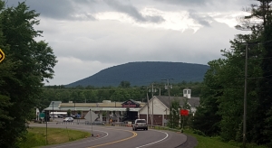
Round Top rises above Cairo

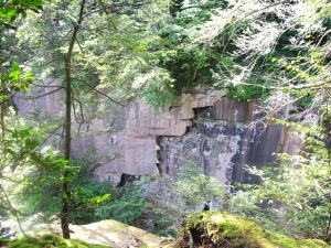
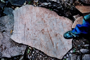
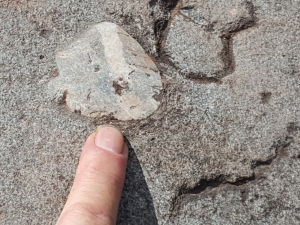
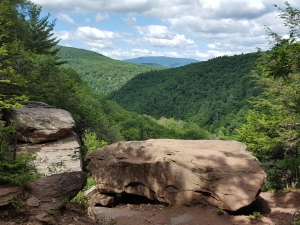
Any geologist, working in this region, would immediately guess that glaciers had something to do with it. And that’s exactly the case with Round Top. The proof comes with a careful look at its upper slopes. Most of Round Top is posted land, but there are several roads that circumnavigate the hill. On Heart’s Content Road, southwest of the hill, you can get a good look at Round Top. Up toward the top there is a great ledge of rock. It’s typical Catskill sandstone. Long ago, nearly 400 million years long ago, that sandstone made up the channel of an ancient river. The quartz sands of that river have hardened into rock. Quartz sandstone is among nature’s hardest and most durable rocks. Hence the cliff, but there’s more than that.

About 22 thousand years ago a very sizable glacier was advancing down the Hudson Valley. It filled the valley right up to the top of the Catskill Front. Indeed, it overflowed into the Catskills themselves. That, however, is another story. The important point here is that much of the time the ice overrode Round Top, the hill is only a little more than 1,400 feet tall and was not much of an obstacle to the flow of the ice. The glacier simply flowed across it.

Glaciers have a very predictable effect upon mountains that dare to get in their way. They tend to streamline the upstream side of the hill. That accounts for the smoothly rounded form of most of Round Top. The other thing that a glacier does is a little more difficult to explain. The downstream side of the impeding hill comes to be sculpted into a steep downstream-facing slope, often a cliff. The process is called “plucking.” The ice apparently adheres to the rock and yanks loose large chunks of it and drags it off. Over time a cliff results, a scar of the plucking process. That is the explanation for that sizable ledge at the top of the south side of Round Top.

Okay, so far, so good, it sounds like we have explained Round Top, but we haven’t. We understand the shape of Round Top but what is it doing there? Our curiosity is about why the mountain exists there at all. You see, the Hudson Valley glacier advanced down the valley at least from 25,000 to 14,000 years ago and that is a lot of time. It also passed down the Hudson Valley about 120,000 years ago during an event often called the Illinoisan glaciation. The passing ice plucked the Catskill Front as well as round Top and over time it sculpted the Wall of Manitou as the Catskill escarpment is sometimes called.

And that is our problem. How come Round Top didn’t get scoured away entirely during all of this glaciation? We don’t know and that bothers us.

Contact the authors at randjtitus@prodigy.net. Join their facebook page “The Catskill Geologist.”

An ice-scoured plain 6-21-18

in Uncategorized by

An ice scoured plain

Robert and Johanna Titus

June 21, 2018


We have been members of the Mountaintop Arboretum at Onteora Park in Tannersville pretty much since it was formed about 20 years ago. We have lost track of how many times we have made presentations there. But we are speaking at the Arboretum once again this Saturday, June 23, 2018 at 10:00 AM. We will be giving a PowerPoint presentation about the ice age and bedrock history of the Arboretum grounds. Then we will be taking our audience outside to do a geology walk across a good part of Arboretum property. It will be an easy walk across a relatively flat landscape. Try to come along, if you can fit it in to your schedule.

You may not be able to attend so we thought we would put together a bit of a quick guide for some time when you will be able to get out there. The main part of the Arboretum grounds are called the West Meadow and that is in the northwest corner of the property. Scattered across the West Meadow are the trees that make up the bulk of the Arboretum. You can visit and wander the trails that are there. You can look at the various species of trees which are all well labeled. There is even some art in the form of stone sculptures.


Map of West Meadow.

But, of course, when we are there, we see the geology, a lot of geology. We will be speaking about it all on Saturday, but let’s focus on the West Meadow today. To get there you travel north on Rte. 23C north from Tannersville until you reach the Arboretum. You can park on Maude Adams Lane and then walk back to the gate to the West Meadow. When we are there, we look across the grounds. What we see is a landscape that shows the effects of glaciation. We see what might be called an ice-scoured plain. That is, we see a glacier sweeping down from the North and overrunning the grounds of the Arboretum.

The most obvious manifestation of that is the exposed bedrock, right there at the gate. The bedrock, here, has been scoured by the passing ice. It has a smoothed and polished look to it. Wander around and look it over. You will, we think, be able to see the polish. Also, look for long straight scratches in the surface. They have a north to south compass orientation. These are glacial striations. If you have been a regular reader then you have seen these before. They were made as the glacier dragged cobbles and boulders across the surface. These are faint impressions and we couldn’t get a good photo, but you should be able to find them without much trouble.

Chattermarks

Next, watch for crescent shaped fractures in the rock surface. These are called chattermarks, they were formed when a boulder was dragged across this same surface. The weight of the ice pressed down, but the push of the glacier pushed it forward. When the push overcame the weight, the boulder “leaped” forward and “landed” leaving the crescent. Over time a series of crescents was formed.


Next, look around and you will soon see a large boulder. That’s something called a glacial erratic. That’s a boulder that was swept up and carried along by the advancing glacier. The boulder reached Arboretum grounds when the climate warmed and the glacier melted away. The boulder has been sitting here ever since the end of the Ice Age.

Glacial erratic

Now you know enough to be able to wander the grounds of the West Meadow. We are sure you will enjoy seeing all the trees that are there. After all, that is why the Arboretum was established. But now you will be able to understand and appreciate that this is an ice scoured plain. Watch for other ice scoured outcroppings; there is a very good on in the southeast corner of the meadow. You will see other glacial erratics as sell; they are scattered about all across Arboretum property. We hope you will just plain understand this landscape better.

Contact the authors at randjtitus@prodigy.net.


Rock jointing in Plattekill Clove 6-14-18

in Uncategorized by

Cabin tales #2 – The Joints

On the rocks

The Woodstock Times

Sept 2, 2010

Updated by Robert and Johanna Titus


This is a new installment of a series on the geology of Plattekill Clove, all written at the little red cabin owned by the Catskill Center for Conservation and Development. One of the great pleasures of staying at the cabin is walking, after full darkness, downhill to the bend in the road and gazing out onto the Hudson Valley. You can only see part of the valley from there, but it is a grand view. The most striking feature is the Kingston Bridge, all lit up and shining in the surrounding darkness. This is Thomas Edison’s breaking of four and one half billion years of nighttime black. Still, Nature had always had her own lightshows. The best part of the evening stroll is, on those occasional nights, when you can turn around and look west, and see the flashes of lightning from an approaching Catskills thunderstorm. If they are in season, the walk back is lit by the lightning bugs serenaded by crickets, and that can be positively intoxicating.

But daytime is when you are most active around the cabin. There are things that can only be seen then. The most rugged part of Plattekill Clove is found at its very top. That’s a complex stretch of canyons called the Devil’s Kitchen. It is a striking feature, easily viewed from the old stone bridge on the highway at the very top of the canyon. You crane your neck and look down what seems, and is, a precipitous drop.

A small stream descending down the mountain from the north has, over the eons, carved this . . . what to call it . . . not a canyon, not a ravine, perhaps just a jagged cut, no a jagged slash in the rock. The walls on both sides are shear vertical cliffs. They are so flat as to almost be shiny. None of this is accidental; the walls of rock that you are seeing are called joint planes.Hundreds of millions of years ago, great tectonic collisions had squeezed these rocks. Later, when the compression was ended and the rocks relaxed, they expanded and became brittle. That’s when they snapped and those perfectly flat and perfectly vertical fissures appeared. You need to pause and really look at them in order to truly appreciate their form, and their beauty.

After forming, so long ago, these joints sat in stillness for almost all of those hundreds of millions of years as the physical laws of inertia prevailed. Silent and unmoving they did absolutely nothing. But, that would change, especially with the coming of the Ice Age. That’s when they began to be affected by the harsh vicissitudes of glacial climates. Water seeped into these joints, it expanded, as it turned into ice in the freezing cold, and that resulted in further cracking. The expanding ice widened the fissures and they became broader and more prominent. That let still more water enter and chemical weathering followed. Nature was working on the old joints. She had become an artist, a sculptor in order to create something aesthetic from them.

But Nature is slow and patient; she is inexorable. The old fractures became active and they began to expand into the rock that lay between the joints. And those new fractures, in turn, expanded and widened themselves. Then they split and then the new fractures split again. Systems of fractures began to break up the rock. Still more water entered and still more ice formed and still more fracturing occurred.

Now the Ice Age ended. The climate warmed up but the winters would still be frigid and ice would perform its engineering at that time of the year, but something new would assist. Nature enlisted a new ally. That stream we spoke of earlier, made its appearance. Streams are also sculptors and good ones. This one descended the mountain and reached the Devil’s Kitchen. There it speeded up the sculpting process. During peak flows, the rivulet becomes a torrent and a powerful one. It can dislodge blocks of rock, sometime very large ones, and haul them off. Slowly, the Devil’s Kitchen took on its present form. One by one, great chunks of rock were knocked loose and carried away. Slowly that slash in the mountain became the steep, jagged and picturesque thing of natural beauty that it is today.

The old artists of the Hudson Valley School of art would have preferred the word sublime over picturesque and they would have had a point. The scene here is sublime in the sense that it portrays nature not as parkland, but as a rugged, certainly wild and even violent entity. We come here stand and we gaze at Devil’s Kitchen and we are overwhelmed by it; we should be. Contact the authors at randjtitus@prodigy.net.

Read their blogs at “thecatskillgeologist.com.”

The top of Kaaterskill Falls – June 7, 2018

in Uncategorized by

The New Kaaterskill Falls trail: Part five: The top of the falls

On the Rocks

The Woodstock Times

Feb 9, 2017

Robert and Johanna Titus


Kaaterskill Falls has always been renowned for its scenic beauty. It first became widely known after the nearby Catskill Mountain House Hotel opened in 1824. From the hotel the young landscape artist, Thomas Cole, went exploring and visited the falls. He painted two of his most well-loved views here, one from the top of the falls and another from the bottom. You will have no trouble finding these images online. The falls have, subsequently, been painted by generations of artists who followed in Cole’s footsteps.

Generations of recreational hikers have also visited the falls and now the new staircase makes such visits much easier and far more practical. We have always admired the scenery at Kaaterskill Falls, but we are different from most others; when we visit the falls or look at those paintings, we see glaciers! We stand at the top of the falls and look down to see a glacier filling the valley below us; as we watch, it slowly rises up the canyon and then we have to step out of the way as it swells up over the falls themselves.  We lift ourselves up into the air and turn around to watch as the flow of the ice continues on to South Lake. Geologists can do that sort of thing.

How can we claim such otherworldly visions, especially as scientists? It is an extraordinary claim and Carl Sagan said it best when he said “Extraordinary claims require extraordinary evidence.” Can we back up our “visions” with evidence? Yes, we can. It all began down at Bastion Falls where we began our trek several columns ago. We had climbed down from Rte. 23A and were about to ascend the canyon. But, we looked around and noticed a number of boulders with remarkable features on their surfaces. Take a look at our first photo; see one of these boulders. Notice that the surface of this rock is covered with large deep scratches. These are called glacial striations. This rock had been swept along with the flow of ice and dragged along for who knows how far. Along the way it was dragged up against many other similar rocks, and each impact left a scar in the form of a striation.

After seeing the first of these down at Bastion Falls, our eyes were trained to notice more – many more. These comprised the “extraordinary” evidence of the glacier that had, long ago, flowed down the Hudson Valley, risen up Kaaterskill Clove and then turned into the falls canyon. We kept finding more of those striated boulders as we climbed up all the way to the bottom of the falls. We realized that we had been following in the path of the glacier that had been here perhaps 14,000 years ago. But, the question remained: had that glacier ascended up and actually crossed over the top of the Kaaterskill Falls themselves. Those falls are 260 feet tall; could a glacier have actually “climbed” over them? We needed more extraordinary evidence. We climbed the new stairs and hiked on to the top of the falls hoping to find that evidence.

At the top of the new staircase a hiker is led to a dirt trail. That trail, in turn, leads to an intersection with the Blue Trail. A right turn there takes you on to the northern rim of Kaaterskill Clove; a left turn takes you to the top of the falls. We went left. Soon we were standing on the great ledge that makes up the top of the falls. We gazed down the canyon below and could not help but envision it filling with the ice of a glacier that slowly rose right up to where we were standing. But had that glacier actually passed this spot; had it risen and continued on to the north? We looked about and there was the evidence, something we had never noticed before at this spot.

It had been very dry in recent weeks and the flow of water was very low. Most of the bedrock at the bottom of the stream was now exposed and on its surface we found the evidence we had been looking for. The sandstone came from a Devonian stream channel and it contained several small quartz cobbles.  These had been carried by that long-ago flow of water. All these cobbles had originally been rounded by the Devonian streamflow. But now, each one had had its upper half planed off. Its flat upper surface had been scraped flat so that it lay at exactly the same level as the surrounding sandstone (see our second photo). We were fortunate to have visited during a drought. Most of the time this ledge is very wet and very dangerous.

These were ice age features that we have frequently seen elsewhere at North Lake. When a glacier moves across a sandstone landscape it is likely to intersect cobbles within the country rock. It will plane right through them. These are fairly common on the Blue Trail at South Mountain and near Sunset Rock, but this was the first time we had seen them at the top of Kaaterskill Falls. They are features unique to the flow of glacial ice; we had our undisputable (and extraordinary) evidence. Our glacier had risen up over the falls and scoured off the tops of those pebbles as it continued upstream. But there was more.

At the top of Kaaterskill Falls lies a gigantic boulder (our third photo). Curiously, it does not have a name, but we immediately recognized it as being what is called a glacial erratic. Erratics are boulders that were swept up in the flow of ice and transported from where they came from and left where they are found today when the ice melted. This erratic had likely fallen off of South Mountain and onto and into our advancing glacier. It then flowed with the moving ice just to a site which would eventually be the top of the falls. Then the climate warmed, the ice melted and the erratic was lowered down to where it is seen today. It’s additional convincing evidence of the local glacier.

Climbing up to the top of this boulder is not easy but it is worth the effort. We did so and found the name Sanford Robinson Gifford inscribed on its top. Gifford was one of the most esteemed members of the Hudson River School of Art. He had painted here and commemorated his visit with the inscription. We wondered if he knew the ice age origins of this boulder.

One final treat for us was to walk down the dirt path that leads to the lands west of the falls. It only took us three minutes to get to the new deck with its knockout view of all of Kaaterskill Falls. We described that in the March 24th issue.

Contact the authors at randjtitus@prodigy.net. Visit their facebook page “The Catskill Geologist.” Everybody else has.


Go to Top