"I will never kick a rock"

Monthly archive

January 2017

Seeing a lake that is not there. 1-26-17

in Uncategorized by

Lake Front Property

Windows Through Time

Robert Titus

June 24, 2010


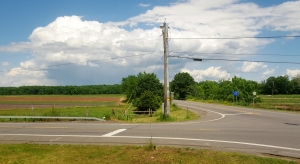
Intersection of Rtes. 32 and 23A

When you have been a geologist for a long time you develop a real sense for the landscape; you gain insight and you just plain notice things that others don’t. With age and experience, you become an increasingly effective observer in the field. In many sciences it is the very young who do the best work. In my science, however, the most seasoned eye often sees the most and the best.

There is one thing, however, that even the most experienced eye finds difficult, and that is seeing what is not there. That happens when Nature has painted a landscape but left something out. If you can notice the absence, you may be awakened to some wonderful moment in the geological past. But, just how do you see what is not there? Well, as I said, it comes with age and experience. And for you that starts right now; give me just a few minutes.

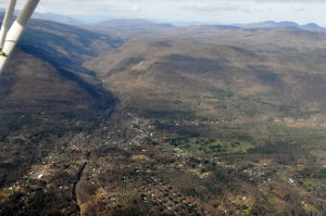
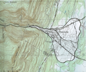
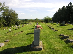
Let’s go to the intersection of State Routes 32 and 23A, just east of Palenville. Look to the northeast and see what you don’t see. There is a fine agricultural field, but what else can you see? The answer is not much. There are no canyons, rivers, no hills nor dales. In fact, there is just about nothing there. I have been by there many a time and I have long noticed that I wasn’t noticing much in the way of real landscape, just a lot of flatness. Well, all along, I did have some interesting ideas. I finally looked it all up in the geological literature and confirmed what I had suspected all along.

This broad flat landscape, so well suited for the farmer’s plow, is sometimes known as the “Kiskatom Flats.” As I expected, the flats mark the floor of an Ice Age lake. The story of this lake takes us back to about 13,000 years ago when warming climates were bringing the late Ice Age to a fitful end. At that moment the Kiskatom flats were something you might call a glacial battlefield. The ice had, earlier, retreated halfway to Albany. Then the climate cooled briefly and the ice re-advanced to the southern end of these flats. That readvance was temporary, and the ice was once again melting away, this time for good.

As the ice left the area, a landscape depression was left behind. With all the meltwater that is produced by retreating ice, this depression filled up quickly and hence the origin of Glacial Lake Kiskatom. The lake waters rose to an elevation of about 360 feet, and my guess is that it was four miles long, north to south, and one mile wide, east to west.

It must have been quite a sight. On its northern shore there was still a great glacier, rising perhaps a few hundred feet above the lake waters. All along the eastern shore there was likely an equally thick glacier. This was the end of the Ice Age and the temperatures were quite warm. All of the ice was actively melting and vast volumes of meltwater were pouring out of the valley glacier. Imagine thundering cascades of raging foaming white water plunging into the lake.

These glaciers were not melting so much as they were disintegrating. From time to time, enormous masses of ice would have detached and crashed down into the lake, breaking into numerous small icebergs. Believe it or not, huge tidal waves would soon have rippled back and forth across the little lake; such things do occur in small lakes.

But what about that flat landscape? These are common throughout the Hudson Valley and into the valleys of the Catskills. As a veteran geologist, I am always on the lookout for them. It has been my experience that these almost always mark the locations of other old glacial lakes. What happens is that the meltwater is dirty with sediment which quickly accumulates as flat stratified sheets on the floor of the lake. Much later, after all of the water has drained away, the flat lake bottom becomes a wetland which slowly dries out into a flat field. The northeast corner of Kiskatom Flats is still a wetland.

There are similar flats along the eastern banks of the Hudson River, that’s Glacial Lake Albany. There is another large flat area in the Schoharie Creek Valley, that’s Glacial Lake Schoharie. And there are more; you can start watching for them. Having just spent five minutes reading this article, you are more experienced and have a better trained eye. It’s time for you to start noticing such things. Go to Kiskatom Flats and see the lake with its bergs, look at the glaciers to the north and east and watch the raging cascades of water. You are seeing what is not there!

Reach the author at titusr@hartwick.edu or find his facebook page “The Catskill Geologist.”

Kaaterskill Clove from the air 1-19-17

in Uncategorized by

Kaaterskill Clove by air

Windows Through Time

Robert Titus

Columbia-Greene Media, Dec. 31, 2009


Recently this blog visited Hyde Park and found that the whole town is a heap of ice age sediment which was deposited as two deltas within Glacial Lake Albany by an ancient version of Crum Elbow Creek, the stream that flows right through the Vanderbilt Estate in the middle of town. This week, let’s visit something very much akin to this on the other side of the Hudson Valley.

Let’s visit the town of Palenville, which is found at the very base of Kaaterskill Clove. Recently, I had the chance to do it by air. My wife and I live next to the Freehold Airport operated, by the Nutmeg Soaring Association, a glider club. I managed to bum a ride into the Catskills. You can see a lot up there and much of it is invisible from the ground.

Kaaterskill Clove with Palenville alluvial fan  below it.


Palenville is one of those Catskill towns with an extensive historical heritage. It has been a place where visitors have long begun their ascent into scenic Kaaterskill Clove. Originally a tough trek, nowadays there is a modern highway so the journey is easy. In the 19th Century Palenville became an artist’s colony. Artists of the famed Hudson Valley School of art commonly spent their summers there and devoted themselves to sketching and painting the area’s scenic landscape.  A lot of very good work was done in the vicinity of the clove. Palenville has always seen a great number of tourists passing through on their ways to the mountains. Today hikers frequent the town.

Geologists have long been drawn to Kaaterskill clove to view its landscape with a more scientific eye. That’s where I fit in to the story.  I love to hike the clove and the mountains north and south of it. There is an awful lot of very good geology to be seen here. So, when I got the chance to fly over it, I welcomed the opportunity. I had a pretty good idea of what I would see and I looked forward to it. Kaaterskill Clove is a great gash in the Catskill Front. Most of it was carved during the Ice Age, especially during the closing phases of that time. Melting glaciers provided enormous amounts of water that cascaded down the canyon, eroding it. Think of it as an oversized gulley!

Kaaterskill Clove had been there before our most recent ice age. It probably began eroding at the end of a previous ice age chapter. But about 13,000 or 14,000 thousand years ago there was another time of melting . . . and another time of erosion. You have to visit the clove and imagine it with deafening masses of raging, foaming, pounding whitewater thundering down its canyon. Erosion would have been going on at an alarming rate.

Where there is erosion, the destruction of rock, then there must also be the production of equally large masses of sediment.  Rock is converted into sediment on a nearly one-to-one basis. The newly formed sediment must be deposited somewhere. That is exactly what I was going to see.

Palenville has long been recognized as something that is called an “alluvial fan.” That is a large, fan-shaped heap of earth. The earth of an alluvial fan spreads out across a dry valley floor at the bottom of the sediment’s source. In this case, large amounts of sediment traveled down an eroding Kaaterskill Clove and then spread out into a fan shape heap at the bottom of that clove.  There was no ice age lake in Palenville so no delta formed here as did at Hyde Park and that is why an alluvial fan is different. It has no flat top as does a delta; it is all slow, gentle slopes.

Map of Palenville alluvial fan.

A trained geologist can recognize such a feature on any good topographical map, and I did this a long time ago. But now, I was up in a plane, and there it was.  As we flew by I gazed into the great wide yawning clove. And spread out before it was the alluvial fan.  I could recognize three roads that I knew. These were Bogart Road, Rt. 23A, and Rt. 32A. The three of them radiated out from the bottom of the canyon and spread out across the top of the fan. Nobody knew it at the time but as laid out those roads all descend the gentle slopes of the alluvial fan.

So, in recent months we have visited two piles of sand, both deposited at the end of the Ice Age. Each fostered the appearance of a town. It is strange how often we humans live upon ice age sediments. It happened so long ago, but it reaches forward through time to affect us. Reach the author at titusr@hartwick.edu and see more at our facebook page “The Catskill Geologist”


A visit to a drumlin field 1-12-17

in Uncategorized by

Drumlins: pretty little hills

Windows Through Time

Robert Titus

Sept. 10, 2010 in Columbia Greene Media


I would like to introduce you to a new geological topic today, one which is very important throughout the Hudson Valley. That is the drumlin. Drumlin is a Gaelic work for hill, but these are very special hills with very special origins. Hills come in all shapes and sizes; they are found everywhere. What makes a drumlin different is its particular shape and the particular type of place where it is found.

A drumlin is said to have the shape of an upside down spoon bowl, so we can start by having you take out a typical spoon, turning it over, and looking at it from what would normally be below. You will see a very nice symmetrical oval shape to the spoon bowl. It is wider at the handle end and tapers to a narrow front. Now turn your spoon sideways, but still upside down and look at it from this angle. The handle end is steep but the angle, again, tapers towards the front.

       A teaspoon bowl, shaped like an upside down drumlin.

   These are exactly the forms we see in a drumlin; you just have to scale it all up in size  . . . a lot. Drumlins can be a mile long, up to 150 feet in height and they can be more than 1,500 feet wide. Most are a good bit smaller, but they are large. They are like potato chips; you can’t just have one. It is very unusual to just see one of them; typically they occur in drumlin fields where they can number in the scores and sometimes many more. And those drumlins fields are, as I said, only found in particular landscapes: areas that had been glaciated.


                                                                    A drumlin field, arrows show direction of glacial movement.

Drumlins display compass directions and those directions speak to us of their origins. Typically drumlins are parallel to each other, and parallel to the long ago flow of the glaciers that formed them. In the Hudson Valley they are commonly oriented north to south.

But how, exactly, did the glaciers form them? Late at night, in geology bars, that issue has been debated for decades. It is not easy to describe the origins of drumlins without using the word sculpting. It would seem that glaciers pass across large masses of coarse glacial sediment and sculpt those materials into the forms we see, but more explanation is needed. The big problem is that nobody has ever been to the bottom of a glacier that was sculpting a drumlin so we can’t go and observe the process.

It may be that drumlins formed late in the Ice Age, when the climate had been warming up. Water would melt out of the glacier and soak into the sediments below. That would make them soft and very pliable and speed up the sculpting process. But, again, nobody has been there to see this happen.

But, for our purposes, something that is very important is that drumlins are scenic and make for very nice landscape. Recognizing them is important to appreciating our Hudson Valley landscapes. You need to see one.

We will, in the future, visit a lot of drumlins and a number of drumlin fields, but today I would like to just recommend a visit to just one, a good one. That would be in the Hudson Valley Hamlet of Viewmonte, along the northern edge of Clermont. Take Rte. 9G south from the Rip Van Winkle Bridge about five miles. Watch on the left (east) for Cemetery Road. Take that left and, less than a mile down the road, you will see a cemetery on the right. If you are not careful you will pass by its inconspicuous entrance so watch it. Drive up that narrow driveway. You have not only entered a cemetery, but you have entered onto a drumlin and a very good one. You are driving up the north end of the hill and this is the steep side. When you reach the top, you will appreciate just how symmetrical a drumlin can be, Steep, but very smooth slopes, form the two, east and west, sides of the drumlin. At the back of the cemetery the driveway forms a turnaround and there you have reached the tapered downstream end of the hill.

                                                                          The top of the cemetery drumlin at Viewmonte

This is a very good drumlin; it has all the morphology that you would expect to see. Being a graveyard, the landscape has been kept open; there are few trees or shrubs to block the view. So this is a very good “introductory” drumlin. We will, in the future, see many more and we will learn about drumlin fields and see what they have to tell us about the ice age history of our region. They, if fact, have much to say.

Contact the author at titusr@hartwick.edu or visit his facebook page ’The Catskill Geologist.”

A moment on the bottom of an ancient sea floor. 1-5-17

in Uncategorized by

A few moments in time

Windows Through Time

Robert Titus


Like many paleontologists, I can well remember the first time I visited a dinosaur. My parents took me to the American Museum of Natural History in New York. There was the magnificent full skeleton of a Brontosaurus. I can remember looking up at it. I was about seven, so that beast looked pretty big to me. So too did a nearby Tyrannosaurus. It’s an experience that helped lead me, like many other youngsters, to a career in the study of fossils.


Every child should have a moment like this. But as an adult, I am often more impressed by things other than size. I am more philosophical now. Time means more to me now than back then; after all, I have known so much more of it. And one type of fossil that impresses me the most is called the trace fossil. That’s something you might well not be familiar with so let me explain. Most fossils, such as those towering dinosaur skeletons, are body fossils; they preserve parts of the original creatures. They are bones, shells or teeth and have lasted so long because they are composed of resilient materials. They are great fossils, but not the only kinds we see.

Trace fossils are different; these preserve the activities of ancient organisms. You can be forgiven if you ask how activities can be preserved in rocks. It does not seem intuitive, does it? But let’s begin with the best known of the trace fossils: the dinosaur footprints. They illustrate what I have in mind. The sizable three toed footprints of dinosaurs are actually quite common. The old monsters walked around in mud and left footprints which eventually petrified to make the most wonderful fossils. Walking is an activity and so these are trace fossils. There are quite a few locations where these can be seen in the Connecticut River Valley of Connecticut and Massachusetts. Someday I will describe one of them for you to go visit.

Dinosaur footprints from the Connecticut River Valley


But, what I have in mind are the traces of creatures that are a lot more modest. These fossils are so humble that they don’t even have a proper name. These are the traces of animals that burrowed across marine sediments almost 400 million years ago when our region was beneath the waves of the ancient Catskill Sea.

Take a look at my illustration and see what I am talking about. This is a slab of local sandstone. It is from near the top of an outcrop that lies along Rte. 23, just east of Five Mile Woods Road, just east of the town of Cairo. That outcrop was overrun by a glacier back during the Ice Age, and that glacier polished this surface, bringing those traces into sharp detail. This sandstone was once lying upon the bottom of the sea and that seafloor was alive with living creatures. Often I see the shells of ancient invertebrates on such sandstones, and a number of such fossils have been found at this outcrop.

            The burrows on Rte. 23

Notice the back and forth motion displayed with these traces. Some sort of creature was moving in this fashion, probably right on the floor of the old sea. There is a series of small “wiggles” inside of the larger ones (the third photo). This is pretty complex behavior from what must have been small and simple animals. These lines are the traces. Once, long ago, some sort of a simple invertebrate animal was mucking about across the sediment at the bottom of that sea. Today, lot’s of animals live in this sort of habitat. They dig across the mud. They actually travel, and in so doing, they leave their burrow traces behind.

Close up of same burrows

What kind of animal was it? I don’t know. If you force me to answer the question I would first guess that it was some sort of a worm, but I really don’t know. Some of our readers have observed snails producing these sort of movements. Where was this creature going? Here I can only guess that it was just wandering and it did not know itself where it was going. Worms and snails don’t carry maps you know; they have no idea where they are going.

What was this creature doing? Here I can come up with a reasonable answer: it was very likely looking for food. That’s the motivation for a lot of animal activity. It is even possible that, if it was a worm, then it was eating the very mud it was digging through. Modern earthworms do that and there is no reason to suppose and ancient worms did not. Snails make these motions as they scrape algae off of the sea floor.

In the end, however, what is so remarkable about this fossil is how ordinary it is. This is not the skeleton of a towering dinosaur; it only records the very existence of a humble invertebrate animal; there was nothing remarkable about what that creature was doing. It was simply going about its daily routine on the floor of an ancient sea. It is the extraordinarily everyday nature of this that makes it of note. When we look at this fossil we are sharing a few minutes or so in the life of an invertebrate animal. I find that astonishing. Contact the author at titusr@hartwick.edu or find more at the facebook page “The Catskill Geologist.”


Go to Top