"I will never kick a rock"

Monthly archive

December 2016

A deep sea landslide along the Mohawk River 12-29-16

in Uncategorized by

Our reader’s rocks: the submarine avalanche

Windows Through Time

Robert Titus


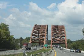
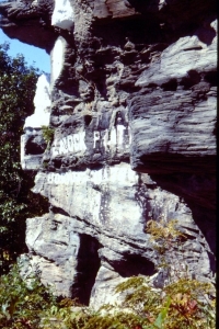
   Dear Professor Titus: I found this peculiar looking rock at my son’s new home. This rock came from an outcropping along the Mohawk River near the Twin Bridges of the Northway. What are the markings on the surface? What can you tell me about them? Mrs. Deborah Teator, Greenville.

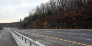
Dear Mrs. Teator: Yes, this is a very interesting rock and I can tell you a great deal about it. The state geological map indicates that your rock is from the Normanskill Formation and that is a unit that I have been meaning to write about anyway so I am glad that you asked about it. The Normanskill makes up much of the bedrock in the Hudson Valley and it is a very important unit of rock in that region. It has quite a story to tell, when you look through a window of time.

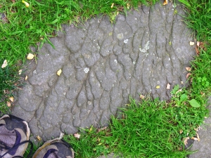
The rock is a very dark type of sandstone which is called graywacke. We geologists sometimes call it “dirty sandstone.” The “dirt” is a large amount of silt and clay which is mixed with the sand. Graywacke is a special type of sandstone which generally forms in a special type of environment. That is the bottom of a great marine trench.

If you know your way around the bottom of the Pacific then you will know what a marine trench is. If not, take a look at most any globe and find the dark blue stretches out there in the middle of the Pacific. The best one is the Marianas Trench, adjacent to the Marianas Islands. A trench is just what it sounds like; it is a long deep crease in the floor of the ocean. I am not kidding about the deep part; the Marianas Trench is about 36,000 feet deep, deeper than Mt. Everest is tall!

The slopes of a trench are, not surprisingly, very steep. Because of that, the soft sediments that accumulate on those slopes are very unstable. If anything jars those slopes, then it triggers a submarine avalanche. Great masses of sediment are kicked up into big smoky looking plumes of dirty water.  These sediment laden plumes are denser than surrounding seawater and thus they, slowly at first, start moving downhill into the depths. These “density currents’ soon pick up a lot of speed and they become submarine avalanches. These are, like their snowy counterparts on land, very dramatic events and they reach speeds of 30 to 50 miles an hour.

They can be destructive events as well, just like the ones on land. These fast moving masses of dirty water are very erosive. They sweep across the muddy deepwater slopes and pick up more sediment and carry it away. That makes the current bigger, heavier and even more powerful. Eventually these avalanches reach the bottom of the trench and the slope flattens out. That’s when the currents slow down and, with time, come to a rest. That is also when the sediment is deposited. The event has a technical term; it is called turbidity current. The resulting sedimentary deposit is called a turbidite.

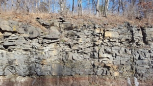
Toward the end, when the masses of dirty water are slowing down, they press into the soft sticky mud below, and they create some very recognizable features. These are called sole marks and it is sole marks that adorn the surface of Deborah Teator’s rock. What I am saying is that this is a “petrified avalanche!” That might, at first, seem impossible, but my description is of something that marine geologists have observed in the modern Atlantic Ocean. We simply know that these things happen.

So, all this speaks volumes about the Twin Bridges vicinity. Back in time, during the Ordovician Period, about 450 million years ago, this was a very different place. This was a deep marine trench. How deep? I don’t know but 20,000 feet seems reasonable. It was a very quiet, very dark seafloor. But, every once in a while, an awful catastrophic submarine avalanche swept by. After it was over, things quieted down again. The next time you are crossing the Twin Bridges, please remember to think about all this. It really rearranges your sense of reality. Doesn’t it?

Do you have an interesting rock, an interesting outcrop or some puzzling landscape feature? Then e-mail the author at titusr@hartwick.edu or write him at Dept. Geology, Hartwick College, Oneonta, NY, 13820. Send photos if you can.

A sinking Catskill Delta 12-22-16

in Uncategorized by

Time in Winter, part three

Windows Through Time

Robert Titus


The outcrop on Rte. 23. Dark stratum in middle marks boundary between 2nd and 3rd cycles.


We have been philosophers, contemplating time itself these past few weeks. We’ve been gazing up at the Catskill Front. There, before us, were millions of years of history: petrified into the strata of the Catskills. Rip Van Winkle spent 20 years sleeping up there, but those rocks have slept for nearly 400 million. I’d like to take you up there to see those venerable lithologies, but it’s winter and not a very good time to climb up into the mountains. Fortunately, we won’t have to wait for spring; there is a better strategy.

The Catskill sequence, happily for us, begins in the Hudson Valley. You can go and see its strata, up close and right along the highway. No climbing is needed. Find your way to the intersection of Routes 32 and 23 near Cairo. Then travel just the shortest distance east on Rte. 23. There, alongside the west bound lane, is a fine outcropping of strata. These are mostly sandstones, but there is some shale as well. This is the Catskill sequence up close. These are virtually the same rocks that make up all of the Catskill Front. We have been gazing up at them, but here we can look them right in the eye.

And maybe it is time to stop being philosophers and start, once again, being geologists. Pause and survey the whole outcrop. You will, I hope, be able to see that it is broken up into three separate horizons of stratified rock. In other words there seem to be three “packages” of strata here, laid out, one atop the other, in a vertical sequence. As geologists, we always start at the oldest layers of rock and those are the ones at the bottom of the outcrop at its western end. That first package of strata is the least well exposed but let’s start there. You will see a sequence of thickly bedded, light colored sandstones. Above them the stratigraphy grades into finer grained, thinner bedded material. This has a greenish gray to brick red color.


Red strata at very bottom are overbank floodplain sediment. Gray sandstones, above, are river deposits. Notice some river strata dip to the right. These are typical river cross beds.


This stratigraphy is repeated in the next package and in the third. In other words we are looking at cyclical events in a cyclical stratigraphy. In the second package you can see that many of the thick sandstone strata are inclined to the west (left). This is typical of river channel sediments. Each of the three cycles begins with this sort of river channel sandstone. The overlying, finer grained materials are petrified soil profiles, literally fossil soils. So, if you follow all this, each cycle represents the presence of a Devonian age Catskill Delta river channel, overlain by a floodplain soil. And it happened three times.

So, what was going on here and how does it relate to an ancient delta? There were two sedimentary dynamics back in Catskill Delta days. First those ancient rivers were what we call meandering streams. They formed beautiful, sinuous channels that literally snaked back and forth across their delta floodplains. This process, called river meandering, is a very slow one but it is effective over time and it can still be seen in many modern rivers. But it is slow and that gets us to the second dynamic.

Remember, from those earlier columns, how the sediments of the Mississippi Delta are sinking and that the sinking is slow? Well, our Catskill Delta was sinking slowly too. Gradual river meandering was matched with slow crustal subsidence. The rivers had a back and forth motion. First the river would meander one way for quite a long time and then it would return. Meandering “back” was easy, but, by the time a river meandered “forth” the crust has already sunk quite a good bit. A new river channel/ floodplain “forth” sequence would be laid down on top of the old “back” one. If meandering continued, and it would, then a third horizon (cycle) would be deposited on the same subsiding delta.

That’s what deposited the three cycles we see on Rt. 23. Did one meandering river deposit all three cycles? I don’t know. Did one or several rivers meander across this site? I don’t know, but it doesn’t much matter. The important thing is that we can look into one outcrop and recognize very typical chapters in the history of the whole Catskill Delta. It was subsiding, its streams were meandering, and all of it behaved very much like the Mississippi Delta of today. The Devonian Catskill Delta was the virtual twin of today’s Louisiana; only time has changed. Now: look at the outcrop and then up at the mountains again and appreciate that these were the kinds of processes that formed all the rocks of all the Catskill Front.

Reach the author at titusr@hartwick.edu and find more at the facebook page “The Catskill Geologist.”


The Catskill Front in winter – Part two 12-15-16

in Uncategorized by

Time in winter, part II

Windows Through Time

Robert Titus

Feb. 11, 2010


Catskill Front in winter


Last week we drove along Rt. 32, pulled over to the side of the road and gazed up at the Catskill Front. We found that, at this time of the year, we could look through the leafless forests and see the rocks so clearly. We became philosophers as we contemplated the millions of years of geological history rising before us.

Let’s look into all this again, and this time let’s understand some of the mechanics of this passage of time. Our key to understanding the rocks comes from understanding the City of New Orleans! Does that surprise you? Read on.

Many of us learned a lot of geology when Hurricane Katrina struck. One of the most remarkable things was that most of New Orleans currently lies below sea level. How could that be? Were people idiots when the city was first founded? Of course not! Three centuries ago, when New Orleans was settled, it lay above sea level. During those centuries it has slowly sunk until now most of it is below sea level. It would have been flooded decades ago except for the construction of manmade levees.

Ironically, the levees may have caused more damage than they were worth. Obviously they weren’t up to the job when the hurricane struck; the city flooded anyway. But there was something else equally important. Floods bring sand down the river and deposit it, spread out across the delta top. That can’t happen if levees get in the way. New Orleans, being surrounded by levees, did not frequently experience flooding, but the city never received the sand that floods would have brought. The city continued to subside, but the sand, which would have kept it above sea level, never got there. That’s an irony!

My point here is that great deltas slowly subside under the weight of their own sediments. As thousands and then millions of years pass by, enormous thicknesses of sand and mud accumulate on them: first hundreds of feet and then thousands. That’s what we are looking at when we gaze up at the Catskill Front. Had there been a city of “Old Orleans” on the Catskill Delta, back during the Devonian time period, then this fossil city would still be up there – somewhere along the Catskill Front.  And it would likely be buried beneath many feet of sedimentary rock. What a strange thought!

But, this is science, and that is where the evidence leads us. When I look up there and see all those ledges of sand, I realize that these are the deposits of great flooding rivers. I see countless cities of Old Orleans and I see countless Hurricane Katrina’s. I go back into time and watch as the old Catskill Delta slowly subsides, and I see all that sediment piling up. Eventually all of these strata sink into the depths. Thousands of feet of new sediments bury the old. The weight of all this is stupendous. And given still more time, and a lot of it, these sediments begin to harden into rock.

Eons of time are now flying by in my mind’s eye and I am nowhere near the end of it. I still have to contemplate the erosion of the Catskill Front to create the wall of rock we see here. Only Nature can do that through the weathering of rock, turning it back into sediment and then the erosion of that sediment. Nature must be very patient. But for a person to stand along the side of the road, to look at the strata above, and see all this is a marvel. These are awesome notions; no wonder a geologist becomes philosophical.

But where did all that sand and mud come from? Now I must stop looking west at that ancient delta and I turn around to look to the eastern horizon. There, in front of me, is the ghostly silhouette of a long lost mountain range. It rises above today’s Taconic Mountains and it dwarfs those puny peaks. The sediments and the sedimentary rocks of the Catskills came from the weathering and erosion of that towering range of mountains, called the Acadians. These may have risen to elevations of about 30,000 feet. I instinctively look up, but they are not there . . . anymore.


   Profile of Acadian Mountains against profile of modern Catskills, Hudson Valley and Taconics

   I look east to west, then west to east. I see 30,000 feet of old mountains (east) having been converted into about 9,000 feet of modern Catskills (west). Old mountains were turned into new mountains. And Nature presents us with a cycle here. That conversion of old mountains to younger mountains will all probably happen again – and then again. It was the English naturalist James Hutton who first understood things such as this. He marveled about time, saying “We see no vestige of a beginning, no prospect of an end.” With his thoughts geology became a philosophical science. Reach the author at titusr@hartwick.edu  Find more at the facebook page “The Catskill Geologist.”


The Catskill Front in Winter – Part One – 12-8-16

in Uncategorized by

Looking at Time in Winter: Part One

Windows Through Time

Robert Titus


Winter is not always the best season to be a geologist. We do greatly prefer the warm months when we are better able to get out and explore. But there are some compensations. This is the season when, with all the leaves down, we can see so much that will be hidden come next summer. I have in mind a good look at the great Wall of Manitou, the Catskill Front. From numerous sites down in the Hudson Valley you can gaze up at this massive wall of sandstone and shale and see details that are usually hidden.

I stopped along the road down in Palenville and did exactly that, and I was soon able to wax poetic about one of my favorite topics in geology. That would be the enormous lengths of time that we see recorded in the strata. We geologists routinely travel back hundreds of millions years into “deep time.” Much of my own work involves Devonian age rocks which are mostly a bit less than 400 million years old. Much of the rest of my work takes me to ice age deposits which are a mere 15 to 20 thousand years old. We geologists get to be a little jaded with all this. What’s a couple of hundred million years in a universe that is more than 14 billion years old? Still, sometimes it is nice just to go and “look” at all that time. That’s what I did in Palenville.

If you get the chance, please do the same. Follow Rt. 32 and pull over someplace where you can get a good view of the Catskill Front. I picked just south of the intersection with Rt. 32B. Gaze up at wall of rock and really appreciate what is before you. There are about 2,000 feet of stratified rock up there and all of it was, originally, sediment. The strata that you can see clearly are layers of sandstone; they make up those many horizontal strata. That’s sturdy stuff and it has held up well in the face of eons of weathering and erosion.

What you can’t see is what lies in between the sandstone ledges. That would be mostly red shale. Shale was mud to begin with and that makes it pretty soft stuff. Nature has little trouble with shale; she likes to erode it away and she is good at that, turning it into soil. So you rarely get to see shale in steep slopes like this. They are there, but they are buried in their own soils.

So, we have a pattern here. There appear to be countless horizons of sandstone, interbedded with equally countless horizons of shale. All were once soft sediments. Layers of sand alternated with layers of mud. And there before us are about 2,000 feet of all this, all deposited one stratum at a time. How long did it take? Well, that’s my main point today: it took a very long length of time!

Geologists estimate that the Devonian time period stretched from 419 to 359 million years ago. What we are looking at here is perhaps about a fifth of the whole. That suggests that what we are looking at are about 11 million years. My estimate is very rough so I will ask you pay it little heed. But we are certainly dealing with millions of years of time, and in Palenville you are looking at all of them.

For all of those millions of years our region witnessed the steady accumulation of layers of sand and layers of mud. Many of these sediments are red and that indicates that they were terrestrial in origin. The red is the mineral hematite and that forms only on land. The sands accumulated in stream channels; the mud of the shale formed on floodplains. This was a great delta, called the Catskill Delta.

You stand along the road, you gaze up, and you are looking at the cross section of something akin to the Mississippi Delta. Imagine if some enormous creature could slice 2,000 feet into the southern reaches of the Mississippi delta. If that giant then peeled away the earth, it would expose a cross section of the sediments of that delta. Those sediments are probably all still soft; they have not yet hardened into rock. But, in every other respect, our slice of Louisiana would look exactly like what we see here.

I spoke of waxing poetic before, and I guess that a person can actually get that way when he contemplates such thoughts. I could have spoken of waxing philosophical and that might be appropriate. We geologists do find all of this very spiritual and maybe that is the best word of all. Reach the author at titusr@hartwick.edu  or at https://thecatskillgeologist.com

Colonel Pratt’s pyramid 12-1-16

in Uncategorized by


Colonel Pratt’s Pyramid

Windows Through Time

Robert Titus

Columbia/Greene Media

July 23, 2009

18-pratt-rock

Prattsville, along the banks of the Schoharie River, is steeped in Catskills’ history. It’s emblematic of the most progressive aspects of the area’s history, and at the same time, it represents many of the mistakes people made as our region developed.

Zadock Pratt was the towering personality in the town’s development. Even today his influences permeate the village. Pratt was a founder of the Catskill tanning industry. From 1833 to 1846 his Prattsville tanneries turned out shoe leather for the New York City market. His tanneries, however, were dependent on the bark of the hemlock tree, and when all of those trees were cut down, the industry closed.

We frown upon the wanton destruction of the Catskill hemlocks that characterized the 19th Century, but our collective wisdom is based up a history of trial and error. It was men such as Pratt who provided the errors.

But Pratt is also remembered for progressive attitudes toward urban planning. His Prattsville was a pioneering effort in the field. He laid out the streets, built the Greek Revival style homes and planted the 1,000 trees that lined the village streets. Pratt founded churches and the town’s academy as well. Prattsville today is still truly Pratt’s town.

Zadock Pratt was a great man, but I suspect history would have mostly forgotten him except for the one singular act of vanity he was responsible for. Pratt, the Rameses II of the Schoharie Creek Valley, is remembered for Pratt Rock, his would-be tomb.

Pratt Rock consists of a series of stone carvings on a glacially cut cliff along State Route 23, just east of town, and overlooking the old Pratt farm. The site is now a town park and open to visitors. You can hike the winding path up the steep slope toward the main carvings. If you tire along the way, you can sit up stone seats thoughtfully carved into the rocks of the mountain.

The main level of carvings displays images and symbols of Pratt’s life; there are carvings of the hemlock tree, a horse which hauled the bark to the tanneries, a strong arm to do the work, along with other emblems of the great man’s life. There is a poignant carving of his only son, who died in the Civil War. Then there is the Pratt burial chamber, the point of it all.

18-pratt-rock-b

                                                         Pratt Rock

   Unlike the pharaohs, Pratt was never buried in the grotto carved out for him. One story is that the chamber was rendered unsuitable for burial by the fact that its roof leaked when it rained. The chamber is still there, and when I looked it over, I found there may be some truth to that tale, along with a good geological story about Pratt Rock.

Pratt Rock is carved into sedimentary strata from the old Catskill Delta. Deposited nearly 400 million years ago, the sediments here record the coastal regions of a delta similar to that of the Mississippi River today. This was once the coastline of the old Catskill Sea. Rivers flowed, back and forth, across this location and emptied their waters into the old ocean.

There is thus a lot of geological history here. I had little trouble finding bits and pieces of the old Gilboa Forest, and I could picture its foliage along the old stream banks. But the most interesting horizons I found were those at the burial chamber.

The ceiling of the chamber is made up of inclined strata. These horizons of rock formed on the sloping floor of an old stream channel. The beds slant down to the right, away from which was once one side of a river, and farther along the outcrop, they rise up again onto the river’s other shore. When I looked at the chamber ceiling I found a horizon rich in a hash of broken plant remains. This stratum is likely porous and it’s quite possible that accounts for the leakage that caused the burial project to be abandoned. The pharaohs of arid Egypt faced no such problem.


18-pratt-2

                                           The burial grotto, at bottom

   And so it is that this in one of the many ironies of geology. The great Zadock Pratt is buried in a nearby graveyard with all the common folk of old Prattsville. That indignity may be because about 380 million years ago some inconspicuous river made a wrong turn. It’s not Pratt buried in Pratt’s tomb, but the sands of an ancient river! Contact the author at titusr@hartwick.edu Join his facebook page The Catskill Geologist.


Go to Top