"I will never kick a rock"

Monthly archive

November 2016

The lengths of time 11-24-16

in Uncategorized by

The lengths of time

Windows Through Time

Robert Titus

Columbia/Greene Media

July 9, 2009


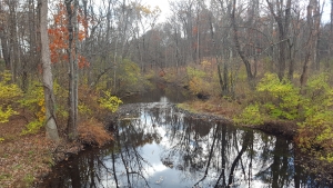
One of the most scenic wonders of our region is Kaaterskill Clove. It is a breathtakingly beautiful canyon cut right into the Catskill Front. It is the sort of landscape feature that one normally associates with the great American West, but it is right here.

17-kaater-4-2


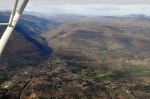
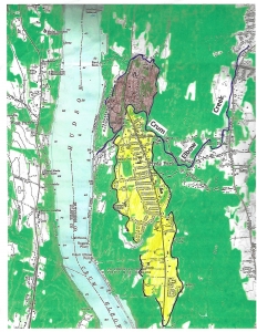
Kaaterskill Clove from the air


17-poets-ledge 

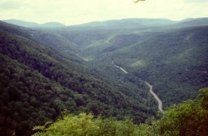
The clove from Poet’s ledge


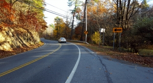
There are trails which navigate hikers around the rim of this canyon, but for most, the easy way to enjoy the views is to drive Route 23A, up or down the canyon. It is a grand experience, any time of the year.

You have probably driven the highway, but I don’t imagine that you put much thought into the bedrock cliffs that line the road. They are pretty; they contribute so much to the scenery, but think about them? Not many do that. Too bad, there is much to ponder here.


Let’s take a ride up the clove.


Our trip starts out at the western edge of Palenville. The highway crosses a bridge there and we get our first glimpse of the rocks. I would like it if you paid attention to your driving, so just give those rocks a few glimpses. You will quickly note large ledges of sandstone and that is about all you need to see here for now. You will very soon pass another huge cliff and then cross More’s Bridge. A quick look at the cliff will reveal, again, a sequence of red shale and brown sandstone. Now is the time to begin pondering what we are actually seeing.

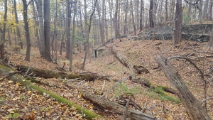
Keep heading up the canyon. Not too much farther up the road there are a couple of places where you can pull over, get out, climb down and take a more leisurely look at the rocks. Just across the canyon from the highway is something called the “Red Chasm.” Its name is well chosen because it is a very handsome shade of red. Take a good look and you will see thick layers of red shale. These were, long ago, formed as floodplain deposits. Then too, there are a large number of thick ledges of gray and brown sandstone. These were once the deposits of river channels. What you are looking at is an ancient delta. It’s called the Catskill Delta and back during the Devonian time period it boasted numerous rivers flowing across its surface.
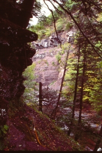
17-2-red-chasm-2

                                                                                                         The Red Chasm

Floodplains and river channels; you have just learned about 90% of what there is to know about Catskills geology. As you travel throughout mountains, it is red shale and brown sandstone that make up most of the bedrock that you will encounter. And that will prove true for the rest of our drive up the clove.

Each stratum of this sedimentary sequence represents a short chapter of time. Each had its turn being the surface of the Catskill Delta. The top of each red shale stratum was once the surface of the ground. If you could travel back through time then you could walk on that surface and leave footprints there. You could return to the present and go searching for your own fossil footprints. Too bad we can’t time travel, but we can’t. Not literally.

Let’s continue our drive uphill. We will pass more outcrops of sandstone and shale. We gradually begin to appreciate how much time is involved here. Each horizon of rock really was the surface of the Catskill Delta for a brief moment, so long ago. Each of those landscape surfaces would have, back then, had the look of permanence about it.

But that look of permanence would have been deceptive. It is by driving up the canyon that we begin to “see” the passage of time. The strata, as we pass them by, record the history of the deposition on the Catskill Delta. They record time itself, a lot of it, and we are traveling through that time.

Our journey up the canyon will eventually take us into Haines Falls, passing many more strata of sandstone and shale – and a lot more time. We will have passed by a thickness of about 1,200 feet of strata. Try to imagine, for a moment, how long it took for all that sediment to be deposited on the Catskill Delta. It must have been many hundreds of thousands of years and, quite possibly, millions – I do not know.

But just how thick is the whole Catskill Sequence? I asked Dr. Charles Ver Straeten, research geologist of the New York State Museum, and he told me that he had just made that calculation. From the bottom of the Devonian sequence, in the Hudson Valley, to the top of Slide Mountain, there are about 9,000 feet of stratified Devonian sandstones and shales. I asked him how much time was involved in this same sequence and he gave me a chart that showed that, if we read it right, a bit more than 60 million years had passed while those strata were being deposited. Our journey through Kaaterskill Clove seemed to have taken us through an enormous length of both rock and time, but it is perhaps only approximately one seventh of the Catskill sequence! Time, it would seem, is very long.

Contact the author at titusr@hartwick.edu  Join his facebook page The Catskill Geologist. Or visit his blog site thecatskillgeologist.com


The Hyde Park Deltas, Part Two 11-17-16

in Uncategorized by


                               The Hyde Park Deltas – Part two

thecatskillgeologist.com

Robert and Johanna Titus

Nov. 2016

_____

This is the second of two new articles about the Hyde Park deltas.


Last time, we began investigating the Hyde Park Deltas. These ice age features have been recognized by glacial geologists for decades and they are seen on the New York State Museum’s map of New York State glacial geology. That map recognizes two deltas.  But we have found something remarkable and, we feel, revealing. Those two deltas represent two chapters of delta formation. That needs to be explained. So – we are going to, herein, record the sequence of events that we have deduced to, we hope, explain all this. We are, in short, going to record a sequential history of the formation of the Hyde Park Deltas – and thus Hyde Park itself.

1) It all began sometime close to the end of the Ice Age. The Hudson Valley glacier had been melting and vacating the valley, and it left behind a sizable lake. That has long been recognized as Glacial Lake Albany. The lake stretched across the Hudson Valley and, at Hyde Park, it was nearly two miles wide.

   2) Crum Elbow Creek was flowing south by southwest, east of, and parallel to, the lake. This took it across a newly deglaciated landscape. We suspect that, at least at first, it was a far more powerful stream than it is today. It does not amount to much today, but back then, it may have been swollen with very dirty meltwater. It, we think, it (must) have been a very erosive stream.

19-crum-elbow-creek


Crum Elbow Creek today, upstream.


3)  If so, then Crum Elbow Creek had to have carried a very substantial load of sediment which came to be deposited in Lake Albany. Most of that sediment formed what we are calling the Roosevelt Delta (see yellow on our map). The waters of Lake Albany, at that time, reached a level of 180 feet in modern elevation. The delta’s topset was, likewise, at today’s 180 feet.


The Hyde Park deltas; Roosevelt Delta in yellow; Vanderbilt Delta in brown.

two-deltas

4) We conclude that, back then, Crum Elbow Creek did not turn sharply to the west as it does today. Instead, it continued its southwest path which took it past today’s Wallace Center and onward, just a little north of the Roosevelt mansion, Springwood. Its old channel can still be seen adjacent to the parking lot at the Wallace Center (see map and see photo). This is the time when the stream deposited the Roosevelt Delta (again, see our map).


“Old” Crum Elbow Creek, highlighted in red. “New” Crum Elbow Creek (blue) extends off to the west.

 19-old-crum-elbow-ck-in-erd


Now dry channel of “Old” Crum Elbow Creek, just north of Wallace Center. “Old” Crum Elbow Creek once flowed at the bottom of this small valley.

 19-hyde-park-b


   5) Next, there came a time when Lake Albany (suddenly?) drained down to a level of 170 feet. We do not know why, but with that lowering, a remarkable event ensued. A small stream, one that had just begun flowing along the northern edge of the Roosevelt Delta, became quite erosive and, by headward erosion, it worked its way up along that northern flank of the Roosevelt Delta. Stream piracy was now occurring. The path of this stream, “New” Crum Elbow Creek, can be followed along East Market Street (aka County Route 41). It can be seen that this stream had been erosive enough to cut down into the bedrock there (see our photo) and create something of a canyon.

19-east-market

East Market Road follows canyon of “New” Crum Elbow Creek. The creek is just out of sight on the far right; it presumably cut the steep slopes of this canyon.


6) With time, this growing creek would intersect “Old” Crum Elbow Creek and divert its waters into the present-day path of “New” Crum Elbow Creek.  Also, a new delta, our “Vanderbilt” Delta, began to form. This younger episode of delta building apparently did not last as long as the previous one, and the new delta never got to be as large as its predecessor. The old Roosevelt Delta leveled off at 180 feet; the new Vanderbilt one at 170.

7) During the period of stream piracy, “Old” Crum Elbow Creek continued flowing in its old path. But that path was about ten feet higher above the new level of Lake Albany. This higher level promoted active erosion of the “Old” Crum Elbow channel. This old channel is the one visible just north of the Wallace Center parking lot. More of the old channel can be traced through Hyde Park.


More channel of “Old” Crum Elbow Creek (left center) on the Yellow Trail at the Winnakee Nature Preserve, just north of Rte. 9.


8) After stream Piracy was complete, the “Old” Crum Elbow channel was left high and dry as is seen at the Wallace Center today (our photo, above). Another dry channel can be seen immediately north of the old Roosevelt family stables. (See our photo below). That had been a tributary of Old Crum Elbow Creek.


Dry canyon of a tributary of Old Crum Elbow Creek, just north of Roosevelt family stables on the Cove Trail.


Sometime later, Lake Albany dropped the remaining 170 feet, down to its present level. Today’s “New” Crum Elbow Creek came into its modern form by eroding those 170 feet. This is best seen where the bridge crosses the creek at the south end of the Vanderbilt Estate.


Crum Elbow Creek at the Vanderbilt Estate.

We believe that this history accounts for pretty much all the landscapes we see, today, at Hyde Park. It is an account that describes the very origins of Hyde Park itself and is thus a fascinating history. We invite you to tour the town and see the geologic sites that we describe here. Then, take Rte. 9, north and south of Hyde Park, and see what the vicinity would have looked like if the deltas had never formed.

We have long been impressed with how ice age events explain so much of what we see in our scenic Hudson Valley. This is a fine example.

Hyde Park deltas – Part One 11-14-16

in Uncategorized by

            The Hyde Park Deltas – Part one              

   Thecatskillgeologist.com

Robert and Johanna Titus

   Nov. 2016

Most of the time we are re-running old newspaper columns on this site. But we expect to do some original work as well. That is the case here today. We are publishing the first half of a study we recently did on the geology of the Hyde Park ice age deltas. We hope that you will be able to go to Hyde Park and see what we have seen. We are publishing this again because we have new photos for Part Two

______

The town of Hyde Park is built upon a broad flat platform. It’s a natural landscape feature and it needs to be understood. When you drive into the town, we want you to take note of it. From the north, you pass the Vanderbilt Estate with its endless front lawn. Then the highway passes through the urbanized part of the town. That area is just as flat. Farther south is the Roosevelt Library and Museum. See its expansive and, again, very flat grounds. All this flatness begs to be understood. There is a pattern here, and we always say “when Nature presents scientists with a pattern, she demands an explanation.”

We like to bring a barbeque skewer along with us wherever we go. When we want to investigate this sort of flatland we try to drive it into the ground. If there are rocks, which there usually are, we have little luck. But – if the skewer slides in easily – then we have likely found a glacial lake bottom. That is the case at Hyde Park. Take a look at our map. All the yellow is flatland where there are few, if any, rocks in the ground.


19-yellow-crum-elbow

Yellow on map is delta flatland. Base map courtesy of US Geological Survey

But, is this a simple lake bottom or is there more to the story? Notice that, on our map, the yellow flatlands lie at the downstream end of a stream with the unlikely name of Crum Elbow Creek. Long ago, glacial geologists recognized that that all these flatlands comprised an ice age delta, sometimes called the Hyde Park Delta, the delta of Crum Elbow Creek. The New York State Museum map of ice age features actually portrays two deltas here, one north of Crum Elbow Creek, with a second and larger one, just to the south. This is important, and we should name the two deltas. Let’s call the northern one the Vanderbilt Delta (brown) and call the other the Roosevelt Delta (yellow).

two-deltas

Roosevelt Delta in yellow; Vanderbilt Delta in brown.

Back during the Ice Age, there was a sizable lake flooding all of this part of the Hudson Valley. It has been called Glacial Lake Albany. Crum Elbow Creek is a long flow of water and, back then it was likely carrying a lot of sediment. Most of that sediment was deposited as the delta where the creek flowed into Lake Albany. The top of a delta is always flat and it roughly corresponds with the old lake level. That’s called the topset of the delta. That would have been at about 180 feet in today’s elevation.

The front of a delta is typically a steep slope called a foreset. That explains another landscape feature that we see throughout Hyde Park. Take a look at our photo from the Vanderbilt mansion. The mansion was located at the top of the steep foreset slope. That offered the Vanderbilt’s a nice view of the Hudson River. Walk north and south from the mansion and enjoy this view.


vander-f


The Vanderbilt Mansion from the south. Below it is the foreset slope.

 vander-g

Foreset slope, north of the Vanderbilt mansion, with its view of Hudson.

Now we have learned a lot about Hyde Park. You are not likely to be able to pass through town without envisioning yourself in a very different landscape, an ice age one. With your mind’s eye look west and see Glacial Lake Albany spread out before you. It extends all across the Hudson Valley. The lake was almost two miles wide here. That’s about four times as wide as today’s river is.

But, the more we worked the area, the more we saw problems that needed to be explained. For starters, we thought the flow of Crum Elbow Creek was a bit odd. The stream has its head about ten miles north of Hyde Park. It flows in a remarkably straight line, just a little west of south, all the way to Hyde Park. Much of the way, it follows Rte. 9G. But then, at the village of East Park, it turns sharply to the west and flows directly into Hyde Park and, from there, into the river (see our maps).  Back during the Ice Age, that took it right into Glacial Lake Albany. We wondered if there was a story to that sharp westward turn. We are scientists; again, we are supposed to wonder such things.

Then it began to bother us that Crum Elbow Creek did not match the delta all that well. It certainly did a good job of explaining the northern part of the delta, the Vanderbilt Delta. But how was it that the delta spread out so far to the south? How could delta sediments extend a full two miles, south of Crum Elbow Creek? In short we just did not think that Crum Elbow Creek was accounting for the Roosevelt part of the delta complex. Again, we are scientists.

That’s when another problem appeared. We were now looking more carefully at the map and we suddenly noticed that, while there were two deltas at Hyde Park, they were also of two different elevations. The Roosevelt Delta, south of Crum Elbow Creek, had a topset at about 180 feet in elevation, but the Vanderbilt Delta, north of the creek, lay at just about 170 feet. We were, clearly, looking at two separate events.

This is when it started getting exciting. We soon had a flash; all of a sudden we saw what had happened, and that was a genuine epiphany. We will be back next Thursday with the solutions to these problems, but in the meantime we want you to have a chance to ponder them, and see if you can come up with the solution yourself. We leave you with a blown-up version of our map, focusing on the southern part of the Roosevelt Delta. Take a good look and see if you can solve these problems without our help.

Do you have some ideas? Write to our facebook page “the Catskill Geologist.”

hyde-park-labeled-and-colored

Close-up of the southern delta.

The blues on a rainy night 11-3-16

in Uncategorized by

THE BLUES ON A RAINY NIGHT

On the Rocks

Robert Titus

The Woodstock Times

Nov. 21, 1996

This is an old one, from my first year at the Woodstock Times. This column has been adapted for several editions of “The Catskills: a geological Guide.”


“Carved in stone” is a common enough cliché. Its meaning is plain enough: any concept etched in stone is permanent, it will never go away or be altered. There is an important implication in the term; something carved in stone must be of some real importance. Otherwise – who would bother?

To a geologist things carved in stone are much more commonplace. Lots of things are carved in stone. Some of the most mundane events have, by happenstance, been recorded not by a skilled engraver, but by the everyday events of nature. If you know what to look for, sometimes the rocks light up with unexpected etchings.

You have, no doubt, commonly walked the sidewalks on a rainy night. To the young and in love it can be a great pleasure; to most of the rest of us it’s just cold and wet. But, in the Catskills, a dark, rainy night can bring a journey into the past. You see, most of our Catskill villages still have a lot of old bluestone sidewalks, and each old slab can be a time machine.

Bluestone has long been quarried in the Catskills. This durable and attractive stone holds up very well to the traffic of feet. It was deposited nearly 400 million years ago mostly near the coastline of the ancient Catskill Sea. Its sands once traveled down the rivers of the Catskill Delta and came to be deposited as flat sheets on the shallow sea floors or within the river channels themselves. With time came hardening and then lithification. With a lot more time came quarrymen to chisel out these stones and cut them into sidewalk slabs. Now they line our streets, but they often still retain vestiges of their venerable past.

Go out, find some bluestone walks, and really take a look at them. Most Woodstock sidewalks are now of concrete, but there still are some old bluestone slabs. Look at the sidewalk along the cemetery on Rock City Road, and on Tinker Street near Maple Ave. Look also at the stones leading to people’s front doors. Many are featureless, but many others display sedimentary structures which take us back to moments of time in the Devonian.

Look for two of these structures. The first is the most obvious; these are the ripple marks. Devonian age currents passed across these Devonian sands and sculpted them into the delicate ripples. Often the ripples are steeper on one side. That steep side is inclined toward the direction the current was flowing. It is a most remarkable experience to visualize these briefest and most ephemeral events of so long ago. They should not exist. How could such delicate structures survive long enough to turn into stone? And yet, there they are. Were these currents of any importance? Not at all; they were just the most everyday of events and yet they are “carved in stone.”


16-ripples-2

Bluestone slab with ripple marks


The other structure is the flow lineation. Again as currents sweep across sea floors or stream bottoms they sculpt the sand. This time the resulting feature is virtually invisible. The grains are lined up into a subtle lineation which only appears millions of years later when the stone cutter splits the rock. The resulting fracture has a faint lineation to it.


15-1-flow-lineati-3

Bluestone slab with flow lineations, oriented lower right to upper left


Both of these features are quite clear in broad daylight and not much harder to see at night, under street lights. But on a rainy night, when the street lights are reflected off the wet sidewalks, these features light up. They are almost electric. It’s something to look for anywhere there are bluestones, which is all of eastern North America. I found a lot of flow lineations on the bluestones of Woodstock, but only one good ripple marked slab. That was on the first place I looked: the doorstep of Woodstock Wine and Liquors.

So you don’t have to be young and in love to enjoy a walk on a dark rainy night. Ripple marks and flow lineations are nice too, although they do come in a distant second place.


March 14th, the year 387,469,184 BC, late afternoon

All day long, very moist air has been rising up the slopes of the Acadian Mountains, and this has triggered a series of severe thunderstorms. Dark banks of towering storm clouds rise above the 32,000-foot-tall mountain peaks. A great col lies between two adjacent summits, and this forms a huge geographic bowl. Three closely spaced lines of thunderstorms have unloaded, in quick succession, upon this vicinity, and the rains have flooded the bowl. The rain of the first line of storms quickly waterlogged the soils and the subsequent torrents have raced off downhill in deep, fast-flowing erosive streams. Deep gullies have been rapidly cut into the soft, blue-black upper slopes of the bowl. Vast amounts of sediment have been mobilized and a thick ooze of dirty water (in fact, almost watery dirt) has funneled into gullies too numerous to count. Downslope, the gullies combine into several powerful cascading streams. The flows are now too great to be accommodated by the temporary channels they have cut, and so the deep channels are being widened rapidly. More dark earth is engulfed by the erosive powers of the expanding flows, and whole earthen slopes crash down into the torrent. The rush of the confined water is being pushed and hurried along by the great amounts of water backed up behind.

From various compass points, similar flows combine to a point well down on the face of the Acadian massif. Here, today’s cascade, and many earlier ones like it, have combined to carve a great vee-shaped cleft in the mountain range. This gap dwarfs the canyons above it. Through this cleft, on this day, flow several large Niagara’s; this is a catastrophic event, a thousand year flood.

Below these narrows, the Acadian slopes level out. Vast piles of coarse sand and gravel have formed an enormous, rounded apron of sediment, draped against the slopes of the Acadians. As it flows across this slope, the water breaks up into a number of smaller streams, which continue several miles down the gentle slope until a level nearly that of the sea is reached. At sea level, the streams enter a broad, flat delta top landscape, which is a morass of flooded bayous, marshes and ponds.

The drainage of the Acadian slopes thus forms a great hourglass, and this whole drainage system functions as a giant mountain-destroying machine. The upper basin makes up the wide top of the glass where the rain water is gathered. As it cascades down the slope, it erodes into the mountainous landscape. Below, the narrows make up the constricted middle of the hourglass; here the flow is most effective, and water with its burden of sediment is efficiently transported away from the mountain. The gentle slopes reach down to the flat morass that makes up the bottom of the hourglass. This is where all the material eroded from above ends up.

The morass I speak of makes up the great Catskill Delta. Now, its various glutted and disorganized channels of water make their ways toward the sea. These channels are not nearly large enough to hold the water, and they are in full flood. The blue-black floodwater streams have fanned out across the delta plain. Much of the foliage that had grown along the streams has been swept away. Beyond the now-submerged stream channels, the flood currents slow down and the sediments begin to be deposited as dark horizons of muddy sand. Many plants are being buried within these sands; those that had hung on against the currents are being buried in an upright, standing position.

Meanwhile the main flow continues down the channels of the delta. Downstream, the flow is still rapid, but it is beginning to ebb. Colonies of river-dwelling clams are overwhelmed and are quickly buried by masses of sand. These clams have little to fear; muscular and active burrowers, they will not remain buried for long. At the mouths of the Catskill Delta rivers, the waters, dark with sand and silt, are being disgorged into the western Catskill Sea. From above, large plumes of dirty water can be seen slowly expanding out into the sea. Many tree trunks and a flotsam of broken foliage drift seaward, half hidden in the dark plumes.

By midnight the storms have long been over. The skies are clear and the stars shine, competing with a wine-colored moon. The upper slopes of the Acadian Mountains are now dark and silent. Further downstream, the churning flows of the day are still rapid and gurgling with noise, but the normal languid flow of the delta will soon return. The rivers are still dirty, but they are clearing. Offshore the plumes of sediment are settling into thick strata of sticky sand. A large number of shellfish are dying in that burial; they are the ones which cannot burrow to safety. Their shells will lie, buried as fossils, for at least 400 million years.

It has been a very hard day for the biota of the Catskill Delta. But nobody cares. The world of the Devonian is a soul-less one; there is no mourning, no grief, no pity or even self-pity. Indeed, there is no real understanding of exactly what happened today, and by midnight, there are few living creatures who can even remember these terrible events.

Overnight, the currents will slow down enough so that horizontal horizons of sand will accumulate across large expanses of river bottom and seafloor. These deposits will become bluestone.

Up river, the first of many freshwater clams is emerging from the sands, having escaped its entombment. Life goes on.

Go to Top