"I will never kick a rock"

Monthly archive

September 2016

The Wall of Manitou 9-29-16

in Uncategorized by


The Wall of Manitou

Windows Through Time

Robert Titus


A few years ago we celebrated the Quadricentennial of Henry Hudson’s 1609 exploration of the Hudson River this year. It is an important landmark. Hudson made the first serious European exploration of the valley and its river. I am guessing that it must have been an especially fascinating moment for Hudson and his crew when they first spied the tall, blue silhouette of the Catskill Mountains as they were sailing north. They must have wondered about those mountains as the sailed past them. They would never get to go up there. We can.

a-12-catskills-wall-manitou

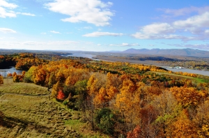
Satellite view of Catskill front

This is the Catskill Front, or if you like, the Wall of Manitou, very roughly the Algonquian words for the Wall of God. It is a very striking landscape feature; stretching about ten miles long and extending from Overlook Mountain, in the south, to North Point, in the north. It is broken twice by sizable cloves. The biggest is Kaaterskill Clove; the other is Plattekill Clove and that is only a bit smaller of the two. You can hike most of the Catskill Front on the Escarpment Trail. That long hike will take you past many very nice views. The hike is a big investment of time, but well worth the effort.

Walking the Catskill Front is one way of enjoying it. The other is to go down into the Hudson Valley and look up at it. Most of us have gazed at this scenic profile of the Catskills. Many of us have favorite vantage points. Mine is from the south porch of artist Frederic Church’s mansion, Olana. There, the mountains never look exactly the same, no matter how many times you visit. There are the winter and summer views, of course. But then there are bright and sunny days when the mountains positively gleam, and also dark days when the mountains are enshrouded in low lying cloud banks. To watch as thunderstorms pass over the Catskills is a grand experience. I think that they must have invented thunderstorms just for the Catskills. On clear dry days at Olana, the image of the mountains seems to expand; I think that the dry air actually magnifies the view. It is always a wonderful panorama at Olana. Church and his family enjoyed it for decades; I envy them that.

a-12-hudson-valley-olana


View of Catskill Front from Olana

To a geologist there are other wonders to the Catskill Front. It has had its mysteries for us. We enjoy its natural beauty, but we also ask questions about it. One of them is “Why is it there.” There is a passage from an article by the late Dr. John Rodgers, a very well respected geology professor from Yale University. He placed himself on the Mountain House ledge, gazing eastward into the Hudson Valley, and simply marveled and wondered as to its very existence. How had it formed? He had many ideas but he did not really know for sure.

The questioning was pertinent. The Mountain House ledge lies at the top of many thousands of feet of sedimentary rock: called the Catskill sequence. Where did it all come from? The sequence thins to the west, but it extends all the way past the Mississippi River; that is a lot of sediment! It was famed 19th Century Albany geologist James Hall who first recognized this. But, he wondered, where did all this sediment come from? He looked eastward, like John Rodgers, and he too could not answer the question. There should have been a great source of sediment out there in the east, but he did not see it.

Another very puzzling question has long been “Why is the Catskill Front so straight.” And indeed, through all of that length, it is most remarkably straight. How could that be? Nature is not too fond of straight lines; she only uses them for the best of reasons. She much prefers random lines. Not here. Why not?

And then there is the direction of that straight line. The Wall of Manitou runs approximate south, 30 degrees west. That is a commonly observed compass direction throughout our region. And, again, the question is why?

My column, this week, is, of course, a teaser. I can answer these questions, I think. And I will over time. But, I guess that my main point here today to illustrate something essential about scientists. We enjoy good scenery as much as anyone else. But, we scientists do look more deeply into the very nature of Nature and we ask so many questions of Her. It is one thing to enjoy the scenery; it is another thing to understand it. Seeking to understand is just our scientific nature. And that is what we have only just begun today.

Reach the author at titusr@hartwick.edu

Flocks of Geologists 9-22-16

in Uncategorized by


Flocks of geologists

Windows Through Time

Robert Titus

June 4, 2009


A-11-Leeds outcrop

Dear Dr. Titus – I have been enjoying your columns in the Hudson-Catskill newspapers. I have a question. I wonder what so many college groups have been studying at the Leeds exit along Rt. 23? – WJM – Athens


WJM: Thanks for the good question. Over the years I have heard this one from a lot of people. Anybody who frequently drives this stretch of the road in the autumn or the spring will have seen sometimes large groups of college students climbing over the rocks at this site. You will be interested to know that this is one of the great “geological tourist traps” of the American northeast. Any eastern geologist who is anybody in geology has been to this location. I wonder if I even know any geologist who has not been here. So, what is the big draw?

The answer is that this outcropping displays something called an “angular unconformity,” and this one is a very historic structure. Read on and learn about this peculiar feature. If you are going by sometime soon, you might want to stop and see for yourself that which captivates so many young geologists. If you do, you will see some interesting geology.

The right (east) side of the outcrop displays what are called stratified sedimentary rocks. These are thick horizons of alternating gray sandstone and black shale. Each layer of rock was once located at the bottom of the sea. Back then, these were horizons of sand and mud. That’s a most surprising observation. Look around. Do you see and salt water here? This does not look like the bottom of an ocean, but it once was. That’s incredible but true.

It has been a very long time since the earliest geologists figured this out. So long that we have forgotten who first made this amazing deduction. That’s too bad, because this was not only one of the most important discoveries in the history of geology but of science itself. Look around and think about it. You are standing at what really was the bottom of a sea. These strata of sand and mud formed on that long-ago seafloor. Times have changed!

But there is something else here and it is also important. Notice that the sandstone and shale strata are tilted, they are nearly vertical. When sediments are deposited on the floor of an ocean they are laid down in horizontal sheets. These strata should have stayed that way, but that is not the case here. Again they are nearly vertical. They must have come to be tilted and that’s where the story gets even more interesting. Think about how heavy these rocks are and how much energy it would take to tilt them. The only processes that can lift and tilt such rocks are those of mountain building events.

These rocks are from something called the Ordovician time period; they are about 450 million years old. That’s when North American was enduring a great collision with an eastern landmass much the size of today’s Japan. You would call it Europe or – better – proto-Europe. Collisions, of this sort, initiate chapters of downwarping. The crust folds downward and the seas flood the region. Those seas accumulated the sand and mud that hardened into today’s rocks. Then continued collision came to reverse the whole process and caused a massive mountain building uplift. All this is how those rocks formed, and how they were tilted and raised to above sea level. But, of course, there is still more.

The rocks on the left (west) side of the outcrop are limestones. They formed during a time that is called the Devonian Period and they are only about 400 million years old. They formed in a shallow tropical sea and the rocks are sometimes rich in marine fossils. If you stop here, perhaps you can find a few. This was the bottom of a second ocean!

These too are stratified, but these strata dip to the left. Once again, North America was enduring a collision with another Japan-sized land mass. It was déjà vu all over again! Once again, the crust was folded downwards and that is when the limestone formed. That downwarping would eventually be followed by another uplift. That’s when the tilting occurred.

The boundary between these two units of rock is the part we call an angular unconformity. It represents a period of erosion that followed the first mountain building event and preceded the second.

And that is the centerpiece of what we, and all those college students, are looking at. This is a petrified record of two mountain building events. There is a lot of history here and young geologists come from all over to see it.  You can too. Contact the author at titusr@hartwick.edu

A voyage of the mind; a voyage to a lake – Kinderhook Cr. Kinderhook 9-15-16

in Uncategorized by

A voyage of the mind, a voyage to a lake

Windows Through Time – May 21, 2009

Robert Titus


We are the mind’s eye, the human imagination, and we are drifting high across the Hudson Valley’s sky, exactly 14,000 years ago. Our present location is northeast of Chatham in the middle Hudson Valley. Below us should be Kinderhook Creek and indeed, way down there we can see a fine flow of water but something is dreadfully wrong. We drop down to get a better look. Stretching behind us, to the northeast, and before us, off to the southwest, is something that cannot be Kinderhook Creek. This flow is a great, thundering, pounding rush of water. To call this a “creek” is just all out of proportion. It is a sideways waterfall, a foaming, raging, gigantic number six cataract of water. It is a tumultuous cascade, and it is heading towards today’s Chatham Center.

We are the mind’s eye, the human imagination. We can go anywhere and we can do anything. We can fly high and we can fly low and we can fly fast and we can fly slow. Right now we drop down and follow this grotesque caricature of a river. Just above the flow, we can feel a fine spray of water rising above it. When occasional glimpses of sunlight occur, we see rainbows, many of them. But mostly it is a gray sky above. We are nearly deafened by the sound of this torrent. It is an incredible vision.

Is this really the Kinderhook Creek? It seems impossible to imagine it as being that usually lowly flow of water. We are the mind’s eye and we can find out very quickly and very easily. We rise up thousands of feet into the air and look to the north. We find what we expected. There we spy another landmark familiar to those of modern times. Out there is Valatie Creek and it is flowing south toward today’s town of Kinderhook. But even so far away, we can see that it too is another pounding mega-stream. We are drawn towards this vision of Valatie Creek with a strong, almost magnetic fascination. We descend and find our way to the canyon that, in modern times, marks the western edge of the Valatie business district. In modern times, most of that canyon is visible and has only a relatively small stream flowing at its bottom. On the day of our mind’s eye journey this canyon is filled with something akin to an enormous fire hose. Again, it is as if we were looking at a sideways waterfall, compressed by the narrow, rocky canyon walls. The canyon is filled to the brim and, here, the power of the noise is worse than deafening.

Now we are most extraordinarily curious: What has caused all this? Where did all this water come from? What are the explanations of the mysteries we have seen today? We are the mind’s eye; we can, once again, rise up high into the air and that is exactly what we shall do. Soon our mysteries will be solved.

To the north we see a distant mass of whiteness, stretched across the entire northern horizon. We advance towards this new puzzlement; we are perplexed, but we soon see what we need to see. We are approaching a great glacier. It extends off to the west as far as we can see. It also extends an equally far distance to the east. This is the Hudson Valley Glacier. Once again we succumb to a state of overwhelming, compelling curiosity. We are drawn north and closer to the ice. At this time, 14,000 years ago, it is closing in on the end of the Ice Age and, on this day, it is remarkably warm.

The end of an ice age can be a violent time. The glacier is not just melting; it is falling apart. From time to time great masses of ice collapse into heaps of white rubble at the base of the glacier. Huge volumes of water are gushing out of the glacier’s front and flowing on, as a single great torrent, into our prehistoric Valatie Creek. We turn and follow that flow.

Soon, to the west, we spy an enormous expanse of water. We rise up again and it spreads out before us. It is a huge lake; it is a full nine miles to its western shore. In the very far distance we can see the Catskill Mountains rising above that distant side of the lake. This is what future geologists will call Glacial Lake Albany. What an experience! In the distant future geologists will only be able to imagine what the lake looked like, but we are privileged to see it in person. Contact the author at titusr@hartwick.edu

A visit to Glacial Lake Grand Gorge 9-12-16

in Uncategorized by


              A mind’s eye visit to Glacial Lake Grand Gorge

                              Robert and Johanna Titus

                       (First presented on WIOX on Sept. 6, 2016)


We are the mind’s eye, the human imagination. We can do anything; we can go anywhere; we can travel as far as we want, we can travel as fast as we want, as high as we want, and as low as we want.

We can even travel through time.

Right now we are several thousand feet above the town of Middleburgh, and climbing higher. It is exactly 14,000 years ago and below us is the whiteness of a glaciated landscape. This is getting toward the end of the Ice Age. We want to see more.

We ascend to an altitude of a 100 miles and then 500 miles. Now we are looking north. Far in the distance, over the curvature of the Earth, lies Labrador. For millennia it has been snowing heavily up there, and the snow has piled up so thick that it has turned into ice and that ice has become a glacier.

Glaciers, of this sort, spread out from their centers and the front of this one is inching its way south. It has spread across parts of Quebec and it is advancing across all of the Adirondacks. Beyond that, some of it is becoming funneled into the Hudson Valley. Glaciations can be complex events and this one gets worse. A lot of the Hudson Valley glacier peels off and heads west up the Mohawk Valley. And then a lessor amount of that ice advances south into the Schoharie Creek Valley. That is a lot of ice, but it is very small compared to the great ice sheet that covers Labrador.

We are the mind’s eye and we have been following all of this from 500 miles up in the sky. Now we drop down to just a thousand feet above Middleburgh. The glacier we have been looking at can be called a valley glacier. It flows, ever so slowly, within the confines of the steep slopes of the Schoharie Creek. Actually, by glacial standards, it is moving along at a pretty good clip. It has been relatively warm these past few decades and the ice has been melting – a little. Great volumes of meltwater have been trickling and then pouring down fractures within the ice. A substantial pool of water lies at the bottom of this valley glacier. It would normally be moving very slowly in a southerly direction, but now it is actually hydroplaning. There are days when it advances a hundred feet or so. That’s fast!

We, the mind’s eye, drift down the valley. We pass Vroman’s Nose. Its giant ledge of sandstone rises above the ice. We keep going south and more cliffs tower above the glacier, left and right of it. We look down and we see many large curved black fractures in the ice. These are crevasses and they result from the stresses that build up within the ice as is moves.  We cannot see this movement, but the crevasses betray it.

We continue to drift south. We are following what will be, many millennia from now, Rte. 30. We pass over what will be the locations of Fultonham and Breakabeen. Have you driven this road? When you return, we want you to stop and get out. Look into the sky and see the ice that was once here. It is something that you really need to appreciate.

Now, we approach the site of Mine Kill State Park and there is a surprise ahead. Suddenly, we pass over the downstream end of the ice. We have reached its terminus. Beyond that are the dark waters of a very sizable lake. Schoharie Creek is one of only a limited number of large rivers that flow north. When a glacier is flowing south, it forms a dam and that is what has happened here. This is Glacial Lake Grand Gorge. It is our main destination today

1-map

Map of Lake Grand Gorge. Dark blue is Schoharie Reservoir

We drift very slowly to the south. The waters here are very dark; the lake is 600 feet deep. We turn around and look back at the terminus of the ice. It is a cliff of ice, rising a hundred feet above the waters. The recent warmth of the weather, and all the melting that has been going on, produces fountains of water pouring out of fractures in the ice. Lake Grand Gorge should be filling, higher and higher, with meltwater. We will be watching for this.

The lake is already very large. It is about three miles wide and it runs about ten or more miles to the south, down the Schoharie Creek Valley. Here it is deep and it will only shallow very slowly, upstream, which is to the south.

We turn again and continue our southward journey, soaring through the air. Soon we are acutely aware that beneath us is the site of the modern day world’s Gilboa Dam. We can look down into the waters and envision the dam and the Schoharie Reservoir behind it. You have, no doubt, seen the reservoir; you most likely think of it as a very large body of water. But it is small compared to Lake Grand Gorge. The reservoir is only about a half mile wide and a little more than three miles long. It is only about 150 feet deep; it is just a pale imitation of what Lake Grand Gorge was.

Now we turn east. In that direction lies a great embayment of Lake Grand Gorge. That is where the lake’s waters flooded today’s Manorkill Valley. We drift east over what will be Rte. 990V. We pass Conesville and keep going. Ahead of us is the village of Manor Kill. Have you driven this road? If you do, we want you to look at the valley floor. It is mostly a broad flat landscape. You would be forgiven if you called it a floodplain, but it is not. This is a lake bottom; it is the floor of the Manorkill embayment. Long ago, lake waters rose 150 feet above. Back then, Manorkill Creek, like many others, was flowing into the lake. They were all feeding volumes of water to the lake; the lake should have been rising.

4-lake-bottom-manorkill

Flat bottom of lake near Manorkill

We turn around and head west, back into the Schoharie Creek Valley. We continue our travel to the south. Soon we pass over what will, in the distant future, be Prattsville. We drift “over the town” and then pass Pratt’s Rock. That ledge of sandstone rises above the lake waters. There were none of Colonel Pratt’s carvings here 14,000 years ago, but the rest of the ledge was much as it is today. Have you climbed to the top of Pratt Rock? If you do, then be sure to look down the valley and see the lake that was once here.

Now we turn to the southeast and follow the lake. In the far distance we spot something white. It is too distant to identify. This is a good time to be the mind’s eye; we rise up a mile into the sky and again look east. In the very far distance we can see the Hudson Valley glacier. Here it is abutting the Wall of Manitou, the Catskill Front. The glacier has filled that valley, right up to its brim and more. Some of its ice has diverted from the mainstream and has been driven up Kaaterskill Clove. A stream of this ice continues into the upper reaches of Schoharie Creek. That is the white we have seen. This is another valley glacier and it is also another dam. The ice has clogged the valley in the vicinity of today’s Hunter. It forms a second, eastern dam, holding back the waters of Lake Grand Gorge. The lake is trapped between two glaciers. We turn around and head back to the west.

We pass Prattsville and see another one of the lake’s embayments. This one extends off to the northwest. Today’s Rte. 23 follows in this path. We drift up this embayment. We can imagine Rte. 23 below us. We reach the site of today’s village of Grand Gorge and see another, lessor, embayment – extending to the west.

This small embayment should be of no particular interest to us, except that we can detect a current of water flowing into it. We look ahead and see that this current is heading toward what is called Grand Gorge – not the village – the gorge itself. Now we are truly drawn – drawn towards this great landscape feature. We appear to be on to something.

We are going in a direction that would take us uphill on Rte. 30 today. But there was no uphill here 14,000 years ago. There was just a flat current of lake water. It was funneling into a narrowing and shallowing canyon. The flow became constricted and it had to speed up. As it speeded up it became increasingly erosive. This is a minor epiphany; we are struck by the fact that we have suddenly stumbled across an explanation for several things that have been bothering us. First of all, this is the current that has eroded Grand Gorge. Have you driven through the gorge? The next time you do we want you to stop and feel the current that was once here. Feel its power. See the canyon it carved.


????????????????????????????????????

Grand Gorge – looking north

Then, we have also suddenly learned why the waters of Lake Grand Gorge have not been rising. This is the lake’s “drain.” This is where water escapes from Lake Gorge. We drift to the south and we see the upper reaches of what is today the East Branch of the Delaware River, sometimes called the Pepacton.

Finally, we have learned why the lake is called Lake Grand Gorge.

On this day there is a powerful stream here, a raging, foaming, pounding, thundering torrent of white water. It is eroding a narrow and relatively steep stream valley, just south of Grand Gorge. Have you driven this road? When you do, you will see what the early Pepacton did here.

We continue our journey, heading south to Roxbury. We have left the waters of Lake Grand Gorge and are now following the newborn Pepacton. Roxbury is our final destination; our trek through time is done.

Glacial Lake Albany 9-8-16

in Uncategorized by

Glacial Lake Albany
Windows Through Time
Robert Titus

A-8 Lake Iraquois
Illustration by Jack Cook of the Woods Hole Oceanographic Institute.

IN THE HUDSON VALLEY, all human history begins at the end of the Ice Age. The final melting of the ice and the release of the valley from the frigid icebox conditions that gripped our landscape for millennia, eventually set the stage for the eventual first human populations to enter the region. But even with the ice age over there was one last obstacle to man’s settlement here; that was Glacial Lake Albany.
This is one of the most fascinating chapters in our region’s geological history. A gigantic lake once stretched from Catskill, across the City of Hudson, and on to Kinderhook. That lake also stretched north to the Adirondacks and south to New York City. It was an ice age lake and much of it must have been, most of the time, covered with thick ice. If you could go back in time and imagine a flight from today’s New York City to today’s Glen Falls, you would traverse the length of this enormous lake. You would have been treated to an awesome sight.
Glacial Lake Albany got its start about 18,000 years ago. At that time a great continental ice sheet had swept south across our part of North America. It originated in today’s Labrador and advanced south to approximately the north shore of Long Island. The ice continued west through New Jersey and Pennsylvania. The ice sheet, from there, stretched out across the whole northern half of North America. Similar glaciers covered much of Europe; it was truly the Ice Age.
But the cold climatic conditions, that allowed this ice sheet to form, were coming to an end. The climate would warm up and the ice would begin to melt. Gradually, at first, and then faster, the ice retreated up the Hudson Valley. But the ice had left a great heap of earth behind. It was a mass of coarse sediment which we call a moraine. The moraine makes up the northern half of Long Island and it lies across much of New Jersey as well. It once stretched across the Hudson River from Brooklyn to Staten Island and that is why there was a lake. This moraine, left behind by the retreating ice, formed a dam which blocked the Hudson Valley. As the ice retreated, meltwater accumulated behind this dam and hence the origin of Glacial Lake Albany.
Beneath surficial layers of ice there was deep water and then there was a lake bottom. You can still see the floor of Lake Albany at many locations. Take Route 9 south from the city of Hudson and as you drive along you will encounter many flat landscapes. The flatness is the bottom of the lake. Most all lake bottoms are like that, being blanketed with thick layers of silt and clay. West of the Hudson River, take Route 9W south of Coxsackie and you will commonly pass by and across more flat landscape. This too, is the bottom of the lake.
The ice on the lake eventually thawed out and even then, it must have been a majestic sight. With the final melting of the Ice Age, all the rivers that entered Lake Albany had to have been swollen with raging, foaming, pounding masses of meltwater. Try to imagine Catskill Creek and Kinderhook Creek and Roeliff Jansen Kill thundering with cascades of water, perhaps ten or so times greater than what you see today. Make these flows louder than any torrent you have ever witnessed. It was certainly quite a time.
Those great streams deposited large deltas in the old lake. Virtually all of Schenectady is built upon a huge delta, left by a swollen Mohawk River. Delta tops are flat and please notice, while driving through these cities, how flat the landscape is. There are a lot of other deltas left along what had been the shores of Lake Albany.
This is important stuff. The last vestiges of the Ice Age disappeared about 13,000 years ago. Then there were a few thousand years of reforestation. And that set the stage for the appearance of Native American Indians. We shall visit this landscape, with its thawing ice, many times in future “Windows Through Time” columns. It is quite something to “see.” Contact the author at titusr@hartwick.edu

A visit to the floor of an ancient lake – Lake Leeds 9-1-16

in Uncategorized by

The ghost of a lake
Windows Through Time
Robert Titus

A-7 leeds

Picture caption – View from Sandy Plains Road, on the shore of Lake Leeds, looking out upon the lake basin.

The ghosts of the past are to be seen everywhere. Take a drive west from Leeds on old Rt. 23B. If there are ghost towns, then I guess there are ghost highways too. Pay attention as you drive along the highway and you will see the ghosts of a long-lost tourist trade. All along the road you will see mostly empty, sometimes abandoned motels and cabins and boarding houses. They were all busy, a half century ago. Back then, this highway had a thriving summer tourist trade. Families drove out from the city and spent a day, a week or even a month up here. I am not sure what all they did, but I suspect the clean fresh air had a lot to do with them coming here. Now it is all gone. There is a big difference between a depressed industry and a nearly extinct one. When I drive down the road, I imagine the Fourth of July weekend of 1959; it was different then.
But there are other ghosts and these ones are a lot older and often a lot harder to see. They don’t come out at night; they are best seen in the broad summer daylight. If there are ghost highways, and ghost industries, then they are also ghost lakes. They can be found in the very same places, too.
Head west, again on Rt. 23B from Leeds. Just past the famous Leeds Bridge notice how the landscape changes quickly. Left and south of the highway is a very flat landscape. It stretches off for quite a distance. There are few good reasons to take notice of this landscape; it is so monotonous. But the geologist looks through a time window and sees the past. This is the floor of an ice age lake.
Suddenly it is about 14,000 years ago. All around it is dark and cold and it is all water. The water is not that deep, but it is murky and very little sunlight filters down to reach the floor of the lake where we are. The lake bottom, all around us, is just dull mud: gray and very cold. Up above, a little sunlight can be seen and, drifting by, are small bergs of ice.
It’s time to move on. Driving about three and one half miles west you reach South Cairo. Turn right on County Rt. 67 and cross the flat lake bottom here. On the other side turn right again onto Sandy Plain Road, and drive back east a short distance. Now, spread out in front of you, is the basin of the lake. You have not likely ever seen an ice age lake before and this is a good one. The flat floor of the valley is the old lake bottom. You can look around and imagine the old shore line. You are pretty much standing on that shore. Continue further east on Sandy Plain Road and turn right onto Indian Ridge Road. You will, in fact, see a ridge of rock here, but to your left, I am guessing is an ice age delta that was deposited in the old lake. This delta was the product of Potic Creek which stills flows south as a tributary of Catskill Creek.
Back, when this was a lake, Potic Creek flowed into it and carried enormous amounts of sediment with it. These deposits were dumped in the lake and piled up as the delta. The top of the delta lies at about 225 feet above sea level. That is an important figure; delta tops mark the approximate level of the lake. The lake bottom lies at just about 140 feet. That makes the old lake as having been 85 feet deep.
The lake stretched out six miles from its eastern edge at the Leeds Bridge. It was a mile across, at its widest and generally about 80-90 feet deep. It was, thus, a pretty good sized lake. But it is gone, entirely gone. What happened to it?
The canyon we visited last week, Austin Glen, stretches east from Leeds. This canyon did not, I think, exist at the time of the lake. Instead, a ridge of rock stretched out across the valley. That comprised the dam which impounded the waters of the lake we have been visiting. Today’s Austin Glen was carved through this ridge by torrents of water that flowed through the lake and on to the south. When the canyon was completely excavated, all the water drained out of the lake and it was no more. Today, it exists only in the mind’s eye of the perceptive geologist. When I drive down the highway, to me it becomes the Fourth of July weekend, 12,991 BC. It was different then. Reach the author at titusr@hartwick.edu

Go to Top