Follow the Science Dec, 29, 2024
THE CATSKILL GEOLOGISTS BY PROFESSORS ROBERT AND JOHANNA TITUS
Follow the Science?
The Mountain Eagle Dec. 20 , 2024
The pandemic wreaked havoc all around the world. But science itself is among the many losers. Polling before the pandemic showed that 86% of American thought that scientists act in the public’s best interest. That dropped to 66% during the pandemic. Those numbers drop even more when only Republicans and/or Independents are sampled. That’s, of course, dismaying to us. We have been scientists, literally as long as we can remember. Both of us began our serious interests in science in our very early grammar school years. Neither of us can remember a time when we did not want to be scientists. We have practiced science as professionals and now, in retirement, we are popular science writers, sharing our lifetimes of work with you. We know science about as well as anyone and we are, to be sure, extremely confident in it and its practices.
Why the skepticism? Well, science and scientists have never been shy about telling people things they do not want to hear. That goes back at least as far as the 1500’s and astronomer Nicolaus Copernicus. Copernicus studied the nighttime skies, especially the planets, and determined that the earth was not the center of the universe. Our planet, and all of the others, rotated in revolutions around the sun. While his idea was “revolutionary” it was not very popular, especially with the Catholic Church. Problems for science only got more abundant as the centuries passed. Today scientists find themselves arguing against all sorts of things that are popular notions, often passionately and widely believed in.
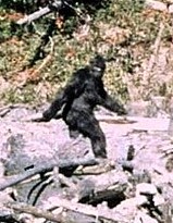
That, quite possibly, includes things that YOU see as true and perhaps even important. Do you believe in Astrology? Do you follow your daily horoscope? If so, you are hardly alone, but science has not found the evidence to support its claims. How about clairvoyance? That too hasn’t been confirmed by proper lab experimentation. Do ghosts exist? They, after all, have sometimes been photographed. The photos are phonies. Have you seen sasquatch? It was recently reported in the town of Cairo, right behind the Dollar General. Naturally we have been watching for Sasquatch, but we have missed him so far. Can someone bend a spoon with their mind? Please! We are indeed skeptics, but scientists are supposed to be skeptics – always.
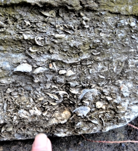
For the two of us these things sometimes strike close to home. Are you a young earth creationist? There are plenty of them. Well, sorry; we are both evolutionary biologists and several peer-reviewed articles about evolution, published in respectable science journals, have come out of our home. Do you believe in Noah’s Flood? If it actually happened, then most of the thousand columns we have published these past 33 years are false. Everything, and we mean everything we know about biology and geology, speaks clearly of a very old planet upon which life has slowly and steadily evolved. One large problem with the acceptance of science is that so many scientists are poor, to say the least, in communicating what they do. The two of us have done as well as we can along those lines.
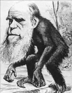
So, what about the most recent loss of confidence, why is that? The answer is that science demonstrates the effectiveness’ of vaccines. We know – we know; all sorts of arguments have been made against vaccines. But the science of statistics is clear: vaccinated people, definitely including the two of us, are not as commonly sickened by the diseases that they have been vaccinated against. They are not as commonly hospitalized, and they do not die as commonly as unvaccinated people. If you insist upon not being vaccinated, then go ahead. The results? Darwin could have explained them better than we can.
Contact the authors at randjtitus@prodigy.net. Join their facebook page: “The Catskill Geologist.” Read their blogs at thecatskillgeologist.com.