Eroding and Old Pebble – Mar. 19, 2026
Eroding an Old Pebble
The Catskill Geologists; The Mountain Eagle; Jan. 17, 2020
Robert and Johanna Titus
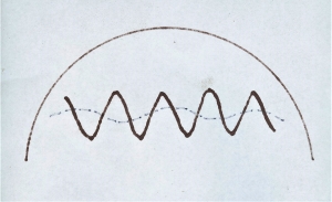
We have been talking about the various processes of the weathering of rocks in several recent columns. Let’s take a break this week and talk about weathering’s sister process: erosion. And, while we are at it, let’s pick one of the very strangest categories of erosion that you could ever imagine. But, first let’s define the process itself. Most types of erosion involve the lifting up of earth and the movement of it downhill and then into a nearby stream. It’s carried in the stream currents toward the nearest sea. Soils and sediments can frequently be eroded by streams and swept off down to the ocean. Do you live near the Susquehanna or Delaware rivers? Then you can look and see cloudy waters flowing past. That cloudiness is recently eroded earth that had lined the riverbanks and been swept up by the passing waters, probably during a recent storm.
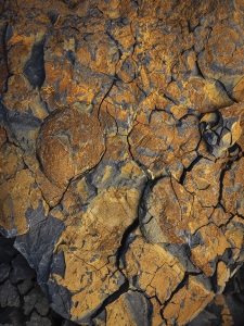
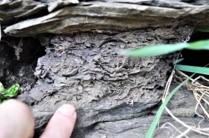
River water is an active agent of erosion, but our topic today is focused on glaciers. “Streams” of ice can sweep up sediments and carry them off just like streams of water. In fact, glaciers are a lot better at that than rivers. Let’s look at our photo. It was taken on the sandstone ledge lying at the very top of Kaaterskill Falls. We were there during a dry spell in August a few years ago. We found this one along with three or four other similar pebbles. They quickly caught our eyes.
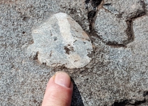
What you see is a quartz pebble that had been deposited in a Devonian age river sand about 385 million years ago. Those river sands eventually came to be hardened into the sandstone that makes up the ledge atop the falls. But, notice that the pebble has been shaved off right to the level of that ledge. How could that be? Shouldn’t that tough quartz pebble rise up above the softer sandstone? Why doesn’t it?
Well, when we spotted this pebble, we immediately recognized what had been going on here. We knew that a glacier had, during the late Ice Age, risen up Kaaterskill Clove and passed across this ledge. Sand, concentrated at the bottom of the passing ice, had cut right through the pebble, planing it off and slicing it in half. That left behind this most remarkable image of a most remarkable type of erosion.
Our columns always aim to give you a trained eye. We discourage you from walking about on the top of Kaaterskill Falls. But we hope that, come next summer, you will walk along the Blue Trail on edge of the Catskill Front, the Wall of Manitou. Back during the Ice Age, glaciers rose up out of the Hudson Valley and swept across the sandstones there. Many of these sandstones also had quartz pebbles buried within them, and many of those came to be planed off by the ice. These are especially common just south of the well-known Boulder Rock, which is south of the Catskill Mountain House hotel site. They are also common on the yellow trail, north of the old hotel. We commonly take people to these two locations and show them these planed off pebbles. It makes a real impression on them and we enjoy seeing their reactions. You can visit and experience your own reactions. We will come back to this peculiar form of erosion next week in our next column.
Contact the authors at randjtitus@prodigy.net. Join their facebook page “The Catskill Geologist.” Read their blogs at “thecatskillgeologist.com.”
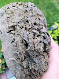
 onian time period, and this rock is about 380 million years old, brachiopods were the most common forms of life. This rock is a petrifaction from one of those Devonian sea floors. But why is there such a dense jumble of brachiopods in this rock? We can never know for sure, but we can hypothesize. We have seen a lot of similar rocks in the Morris region, so we know a good bit about such sea floors. And “jumbles,” like this one, are common.