"I will never kick a rock"

Monthly archive

February 2023

The Rosendale Trestle – Feb. 23, 2023

in Uncategorized by

The Rosendale Trestle

On the Rocks, The Woodstock Times; May. 16, 2016

Robert and Johanna Titus


Have you been down to the newly restored trestle at Rosendale? It’s just another one of those really good ideas that turns up from time to time. You have, quite possibly, been on the walkway that crosses the river at Poughkeepsie. That’s the old railroad bridge that was refit for foot traffic. Now it is a grand tourist attraction. That walkway takes you on an almost breathtaking crossing of the Hudson. Well they did pretty much the same thing at Rosendale, just on a much smaller scale. You have to go and see it!

This had once been an active railroad trestle that crossed the Rondout Creek at Rosendale. That was in the late nineteenth century. Rosendale had, back then, been one of our region’s real industrial centers. It manufactured very large amounts of natural or “Rosendale” cement. They must have needed a railroad and they did have one. That railroad connected New Paltz with Kingston. We rather suspect that stops were made to pick up cement. Both the natural cement industry and the railroads are now just long-ago memories. The railroad closed in 1977, but the trestle survived. It towers 150 feet above the Rondout Creek and it is more than 900 feet long. For a brief time it served as a professional bungee jumping site, but that did not last. It needed to be restored so it could be opened up for foot traffic, and that did happen. The new foot traffic trestle is the centerpiece of the 22 mile long Wallkill Valley Rail Trail. It opened in 2013.

We kept meaning to visit the trestle and we kept putting it off, but finally we did go. It was well worth the trip. To get there take State Rte. 213 through Rosendale and head west. You will pass beneath the trestle. Watch for Binnewater Road, turn right and then left into the kiln parking lot. From there you have access to the rail trail that will take you for the short walk to the trestle. That parking lot is worth the trip by itself; there are a large number of old industrial lime kilns that date back to the natural cement days.

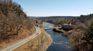
Well, we worked our way up the trail and soon found ourselves out on the trestle.
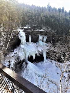
Take a look at our photo to see the view; it is a good one. We, of course, enjoyed the scenery but we were soon dreaming geological thoughts about the landscape before us. Right here, the Rondout Creek passes through something that just falls a little bit short of being a genuine, authentic canyon. The slopes on each side of the river rise quickly and steeply. How did this happen?


We had some research to do. But, fortunately, we already knew most of the basics; we had worked this area before. We knew that the Rondout Valley has had a rich ice age history. Back in time, late in the Ice Age, there had been one final advance of the ice. A valley glacier, a single large stream of ice, had advanced up the Rondout Valley. We are not sure how far it got, but it must have actually approached Port Jervis. Then the climate warmed and the ice began to melt away. That caused a retreat, actually a melting back of the glacier. For a substantial period of time the remaining ice dammed the valley and that caused the formation of a glacial lake called Lake Wawarsing.

Someday, perhaps you will find yourself driving southwest on Rte. 209. After passing Ellenville, you will begin to see a broad flat valley floor. That’s the bottom of Glacial Lake Wawarsing. You will see that it was a big lake and it all lay upstream from Rosendale. Well, we knew every bit of this when we were standing on the trestle. That knowledge was our passport into the past.

The two of us walked to the east side of the trestle and looked that way. We saw the ice coming toward us. The glacier passed us and continued on to the west. Next we walked to the western side of the trestle. It was about 1,000 years or so, later. The ice, that had clogged the valley in that direction, was in the process of melting away. It might be better described as disintegrating. Climate change was in full force. Vast, enormous volumes of meltwater had been liberated by the warming. And all that water was headed toward us. We were the mind’s eye, the human imagination, and we were standing upon an imaginary trestle at a very real moment in time, an important one.

Raging, foaming, pounding masses of whitewater cascaded by, just beneath us. What an image we saw; this was the very day when more volumes of water would pass by than ever had before or ever would again. This was the very moment in time when the Rosendale canyon was taking shape. What was going on just beneath us was extremely erosive.

Off to the west, Lake Wawarsing was draining at an almost alarming rate. And all of that water was thundering by beneath us. The power of the moment was unsustainable; all bad things must come to an end. The lake was emptying. We watched as the currents abated. We gazed as the water levels ebbed below the trestle. We saw something of a normal flow being restored.

We were absolutely thunderstruck by what we had witnessed. We had long understood this sort of thing, but to actually see it is something altogether different. What a gift it is to be geologists; we get to travel to beautiful places but we get to see them as others do not.

Contact the authors at randjtitus@prodigy.net. Join their facebook page “The Catskill Geologist.” Everybody else has.

The New Kaaterskill Falls Overlook Feb 16, 2023

in Uncategorized by

The New Kaaterskill Falls Overlook

On the Rocks; Th e Woodstock Times

Robert and Johanna Titus


It was nearly 20 years ago that On the Rocks first editorialized for extensive trail renovations at Kaaterskill Falls. Now, at last, something concrete has been done and we are so pleased to see the first results. You absolutely have to go and see the new overlook at Kaaterskill Falls. It’s something we have, indeed, been looking forward to for such a long time, and now it is here–and now it is open to the public.

We have written about Kaaterskill Falls any number of times; it is one of the most picturesque landscape features of our region–and certainly one of the best known as well. People have been visiting the falls for two centuries. We have seen initials carved into the rock there dating back to 1810. It was probably landscape artist Thomas Cole who first made it famous with his paintings, done in the 1820’s. Alexis de Tocqueville wrote about it too.

But there have been problems. First, there has always been too much foot traffic, especially on the slopes leading upwards from the bottom of the falls. People are real erosion hazards on slopes of this sort, and the one at Kaaterskill Falls had, even decades ago, become seriously damaged. But there has always been another problem– it is a dangerous place. People walk out onto the lip of the falls and, if they are not very careful, they slip and fall to their deaths. Over the course of the last few summers, it has only gotten worse. Several people died there during each of the last few summers. That endangered the lives of first responders too. It is perhaps more dangerous to attempt rescues there than to just visit the falls. Something had to be done.

Work began in earnest last summer. The whole canyon, approaching the falls from downstream, is being refitted but that project is not complete yet. Trails leading up from the falls and connecting to other trails are still coming along. But the new trail to the upper falls is, indeed, now complete. You get there by taking Rte. 23A up the clove and into Haines Falls. Then you turn right onto County Route 18 and head east. Turn right again onto Laurel House Road and drive to the end. If you have been there in the past, you will be pleasantly surprised by the new parking lot. You will have no trouble finding the new trail. It’s right there. It is paved by some sort of black stuff that we could not identify. It winds back and forth through the woods in a fashion that allows it to have nothing more than a gentle slope, making it all the more accessible for the elderly and, we are guessing here, probably even for those on modern powered wheelchairs.

When you get to the end of the trail you will find a fine viewing platform with sturdy guard rails. The bars are high enough to provide safety and thin enough so that they do not block the view. And what a view it is. This was all very well planned. They were careful to select just the right spot for this platform.  You look down and see all of the upper falls. Our photo could not do justice to this view; you will just have to go there yourself. When we were there, we saw what was left of the mass of ice that forms every winter. You can scan sideways and see, off in the distance, High Peak and Roundtop Mountains. It is a much better view than could ever have been seen in the past.

And we are sure that it will be a lot safer than the old trail, the one that went to the top of the falls. Nobody is likely to want to climb over the bars here, so it is far less probable that there will be so many accidental deaths. If you insist, you can find the old trail and you can go and visit the top of the falls, as in the past. But they have made that trail unobtrusive and we are guessing that there will be much less traffic in that direction. That will only allow limited numbers of people going where the dangers are greatest.

   There must be some good geology here or we would never have paid much attention to the place. There is. Take a good look at our photo. There are three massive ledges of Catskill sandstone, commonly called bluestone. One is at the top, or the lip of the falls, and the second is halfway down and hard to see. The third makes up the platform at the bottom of this, the upper falls. All this belongs to a unit of rock called the Oneonta Formation, a late Devonian aged rock formation that can be traced all across the upper Catskills. It is part of the fabled Catskill Delta. Those sandstones are ancient river deposits. Those ledges were once sands, and that sand filled the channels of rivers that crossed the Catskill Delta.

In between those sandstones are thicknesses of brick red shales. These comprise more of the Catskill Delta. They formed, originally as overbank deposits. That is, they formed as floodplain deposits in between the old river channels. So, altogether, the strata of Kaaterskill Falls constitute a very representative cross section of the old Catskill Delta. We rather guess that many classes of young geologists will be coming this way.

Make sure you go there soon. After all, it is spring. See the scenery and examine the geology. There is more to come, much more. Old trails will be refitted and new ones will be cut. This site is going to be turned into a much better location, a well-integrated system of trails for hiking and for looking at the geology. We will write about that later, when it is all done. But, for now, we applaud what has been done at Kaaterskill Falls. Two thumbs up!

Contact the authors at randjtitus@prodigy.net. Join their facebook page “The Catskill Geologist.”

An essay on time Feb. 9, 2023

in Uncategorized by

Where is it all going? An essay on time.

On The Rocks; Th Woodstock Times, March 3, 2016

Updated by Robert and Johanna Titus


When you climb up to the top of Overlook Mountain, pass the hotel ruins and keep on going. Climb the old fire tower. It’s been restored so you can do just that safely. Like most people you are likely to be taken in by the beauty of what you see. You can turn a full 360 degrees and gaze off in every direction. To the north is the wall of Manitou, that straight-as-an-arrow ridge along the eastern flank of the Catskills. To the south you can see all the way to High Point Mountain in New Jersey. To the west, all of the Catskills stretch out before you. And lastly, to the east is the grand expanse of the Hudson Valley. It is such an experience to do all this. Autumn is perhaps the most beautiful time of the year to do so, but all four seasons are rich and generous in their stunning images. Overlook Mountain is one of Woodstock’s emblems. It is truly part of your town’s heritage. But, here’s a question that probably has not crossed your minds. Where is all that stuff going to go?

????????????????????????????????????


What? You might think the two of us are mad to ask such a question; after all Overlook mountain is firmly planted exactly where it is. Overlook Mountain is not going to get up and go anywhere. Well, we know it won’t get up . . . but . . . it is going to go away. The question is when and to where. We have some explaining to do.

The two of us live inside a tiny dot within the great expanse of a temporal infinity, but we can focus on the vast amounts of time, stretching out behind us and ahead of us. We look into the far distant future and we know what all that time will witness: the demise of Overlook – and everything else that we can see from that fire tower. And, we can look around and see how. We can actually perceive it happening

We look straight down from that tower and see the ground below. We know that, right in front of us, soil forming processes are turning the bedrock of Overlook into the thin soils of that mountaintop. We can’t see those processes; they are chemistry and biology, and they are far too slow. But we know that they are operating – right in front of us.

And, there is more. Slowly, very slowly, those soils are sliding downhill. The sliding is faster during rainy seasons. The rain soaks into the ground. The water allows grains of sand and silt to float just a little bit; they buoy them up. Then those grains slide past each other, and that is almost always in a downhill direction. The soils almost flow as if they were fluids. But again, it is all so slow. None of it can be seen.

Geologists like to stick stakes into the slopes, and come back year after year to see if they have moved. If they are patient and come back often enough, those stakes are seen to have leaned over, and to also have moved, if ever so short a distance; again it’s always downhill. Sluggish as these processes are, they continue through endless stretches of time. And, this is geology; there is always so very much time.

Just a little faster are the processes of erosion. Down the mountain slope, well below the fire tower, groundwater reaches the surface and so is the genesis of springs at the heads of rivulets. Those flows are hardly much of anything at first, but they coalesce into currents that can be properly called streams. Then they join to become tributaries. All along they are increasingly erosive; they pick up and carry away more sediment. We humans lament the loss of what had once been rich soils. But Nature does not care; Nature just watches.

We climbed back up the fire tower and, once again, gazed in all of the directions those 360 degrees gave to us. Now we were more expectant. We became time travelers, something that geologists are so good at. Around us, the foliage of the forest changed from green to gray and then back again. The transitions continued and sped up. We were watching seasons pass. Soon time raced by so fast that the color stopped cycling and became a continuous grayish green blur.

In this accelerated and accelerating version of reality, we watched and began to see the tops of mountains rounding off and then lowering. Steep slopes became far more gentle. The peaks began to dissolve into an ever more rapidly advancing time.

What was happening right before us? The bedrock had been turning into soil and the soils were sliding downhill. Having gone far enough they were swept up in the flows of streams. Those were small at first but, farther downhill, they became tributaries of larger and more erosive flows. Bedrock had turned into sediment and that sediment was being carried off. Landscape was withering away.

We remained on top of that fire tower and the fire tower remained on top of Overlook. But the elevation of that mountaintop was fast declining and the land, all around us, was disappearing. Much of the newly created sediment was carried directly into the Hudson River. To the north the effort was more circuitous. There sediment entered into the Schoharie Creek, traveled to the Mohawk River, and from there it arrived at the Hudson. To the west sediment traveled into the Susquehanna and the Delaware Rivers. In every direction the sediment was flowing away from Overlook.

We watched as, everywhere, rock was turned into sediment and that sediment was carried down the rivers. And, all around us, the landscape disappeared. Where did it go? Into the coastal waters of the Atlantic Ocean. Down there the sand of broad white beaches had once belonged to our mountains.

Geologists have understood the vastness of time for several centuries now. It makes us feel small, but it gives us a large understanding of the world all around us. And we also understand landscape’s place in that vastness of time. We mortals are, indeed, small and ephemeral, but so too are mountains. Nothing, absolutely nothing, lasts forever.

Contact the authors at randjtitus@prodigy.net. Join their facebook page “The Catskill Geologist.”


Noah’s flood and the Catskill Delta. Feb. 2, 2023.

in Uncategorized by

Noah’s flood and the Catskill Delta

On the Rocks; 2020

Robert and Johanna Titus


The two of us have been lifelong scientists. For both of us, our interests in science date back to our early childhoods. For both of us the vast antiquity of earth history and the evolution of life have always been givens. Our opinions count: our lifetimes of studies have never uncovered anything even remotely doubtful about the old Earth theories that underpin our sciences. We have never ever been puzzled by finding anything the least bit questionable about this scientific worldview. But we have long known of the opposition to these views generated from within the Christian fundamentalist community. It dates back to 1859 when Charles Darwin published his book about evolution. That opposition has become more institutionalized in recent years with the establishment of the Creation Museum and the Ark Encounter theme park, both in Kentucky. Its views are widely circulated in some Christian home schooling programs. Our recent columns have been outlining our responses to what is called “young earth creationism.” We continue on that theme today. Defending our sciences has always been important to us — and always will be.

Let’s take you to the Mountain House Hotel ledge, high atop the Catskill front. See our first picture. We are guessing that virtually all of you have been there, perhaps many times. What you probably don’t know is just how thick the stratified rocks beneath that ledge are. Take a look at our second illustration. It is a cross sectional view of Catskills stratigraphy. It was done by our friend, the late Dr. Don Fisher of the New York State Museum. It is based on his lifetime study of Catskills stratigraphy. Don didn’t do the work alone; he was joined in this endeavor by scores of other professional geologists. Earlier generations of geologists preceded Don and all this work is being carried on today by a younger generation of researchers. In short, this is well documented science.


There is quite a story here. The thickest strata are on the east (right) and the strata thin to the west (left). You can make out the Hudson Valley on the far right and next to that is the Catskill Front. The thickest stratigraphy lies right at the top of the Catskill Front. Don estimated it at being nearly two miles thick there. If you get a chance to visit the ledge, then look down and imagine all the stratigraphy that lies beneath your feet. It is more than just a little awesome to fully understand this. But it is something that all of us should know about.


There are generations of oceans down below. The black and the gray at the bottom are limestones and shales of the Helderberg and Marcellus seas. Above them (dotted) are the strata of the Hamilton Sea. We have described all of these in recent columns and made the case for how much time each one of them represents. Today’s column is about the reddish-brown unit in the upper right. It makes up almost all of the stratified rock outcrops that we see as we travel about in the Catskills. These are the strata of the famed Devonian aged Catskill Delta.

We know these rocks well. We have been studying them for decades. When we visit their outcroppings, we see petrifactions from within the old delta. We see a lithic mosaic of delta habitats. We gaze at old riverbanks and channels. We recognize floodplain soils and floodplain swamps. We visit the shallow ponds that are so common on all deltas. From time to time we see the fossils of the primitive trees, shrubs and weeds that grew upon this ancient landscape. We have found fossil freshwater fish that lived in delta waters and we have read about the many invertebrates who lived in these lands. We know the climate’s rainfall had been seasonal back then and we have even seen petrified charcoal left behind by dry season forest fires. We appreciate the delta all the more because we understand that it displays some of the oldest forest ecology known on Earth, something called the Gilboa fossil forest. Not surprisingly, these are all primitive land plants. All in all, this may well be the finest view of a Devonian landscape in all the world.

Look again at our second illustration. These are the rocks we have been speaking of in our most recent columns. There are miles of strata here. It is an enormous unit of rock. It is an important unit of rock. It could not have been and was not deposited by the waters of Noah’s flood!

Contact the authors at randjtitus@prodigy.net. Join their facebook page “The Catskill Geologist.” Read their blogs at “thecatskillgeologist.com.”


Go to Top