Bend in the Road
On the Rocks, The Woodstock Times
May 13, 1999
Updated by Robert and Johanna Titus
As geologists there are so many places for us to visit, but we find that there are also some places that we return to over and over again. One of those is the hairpin turn in the road at Plattekill Creek. It’s exactly 1.2 miles above the bottom of the canyon road. When you get there, you will find a very sharp right turn. The road then goes around another broader left bend and continues up the canyon for another mile until reaching the top.
The bend in the road is just one of those places where we see all sorts of things. First there is an especially fine view. Look west and you see the whole canyon before you. Look back to the southeast and you get a nice peak at the Hudson Valley. At night you can see the Rhinebeck Bridge and part of Kingston. Look west at night and, depending on the moon and the weather, you get all sorts of silhouette effects on the horizon.
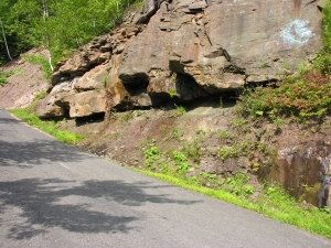
But it is the bedrock geology that we would like to talk about today. A lot of rock had to be cut through and carted off to make way for the road and that has provided us with a fine outcrop. Just before the bend you will see about 40 feet or so of massive sandstone. That is the cross section of an ancient river. we, of course, really mean it when we say ancient. We are talking about the Devonian time period, about 385 million years ago. There was a river here then and it flowed across a vast floodplain. This ancient stream had nothing to do with today’s Plattekill Creek; it is just a nameless river, lost in the annals of Earth history. The river itself was prone to times of high and active flow. If you look at the strata here, you will see the evidence: Steeply inclined strata called cross beds. In our mind’s eye, we envisioned days when very powerful flows of water had passed by here.
Above the river deposit there are five feet or so of red shales. These are old floodplain sediments; they were deposited during the floods that occasionally swept through here. The red color fades at the top in what is an old soil profile. It’s only five feet of red strata, but what a record of time! These sediments record untold numbers of floods and the long slow process of soil formation.
As you round the bend in the road you find another ten feet or so of river sandstones. We look at rivers today and think of them as permanent landscape features, but they are not. Floodplain rivers come and go; they slowly meander back and forth, snake-like, across the flat lands. A river will occupy a site for a long time, then meander off, and much later, it may meander back. Or maybe some other river will meander into the same site. That’s what you see at the bend in the road. First there was one river, then a red floodplain, and then the same or another river returned to this site.
Continue up the road and then you will see that there is still another five feet or so of red floodplain with the paleness of another fossil soil. Above that is the single best geological feature of the site. That second red floodplain is followed by a truly massive river sandstone. There must have been a very large river here, one that deposited a lot of sand, about 50 feet or more. But it is right at its base that we found the best feature. The sandstone has eroded an overhang above the softer red shales. Look under and up at the sandstone and you will find what we call “drag marks.” Drag marks are just that. Something, probably a waterlogged tree trunk, was dragged down the stream by the river currents. It dragged into the muds and left the mark. Actually, there are two of them. They represent just the few seconds it took for a log to move along and leave the drag mark. But those few seconds have been recorded there in the rock, for nearly 400 million years.
The bend in the road is an especially nice exposure of some very typical Catskill stratigraphy. If you spend a little time here and work your way through the site’s stratigraphy you will learn a lot about our area rocks, and it’s not very complex. Basically, the light sandstones are river channel deposits, and the red shales are old floodplain sediments. You can apply what you have learned here, throughout most of the Catskills. That’s a lot of knowledge.
Contact the authors at randjtitus@prodigy.net. Join their facebook page “The Catskill Geologist.”